Systemic Stratigraphy Seminar
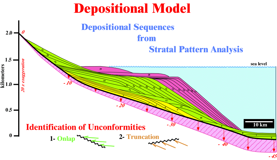
In the sand-shale depositional model illustrated here-below, P. Vail and coauthors (1977) considered sedimentary building blocks which they termed sequence or sequence cycles:
"succession of genetically related strata (or associated seismic reflections) bounded by unconformities or their correlative conformities deposited during a 3rdrd order cycle of sea level change between two relative falls of sea level (Mtchum et al., 1977)"
Fig. 1.1- This depositional model was proposed by P. Vail and co-authors for sand-shale facies. Three sedimentary intervals bounded by unconformities (significant relative sea level falls) are, easily, recognized. They have been named sequence cycles, i.e. stratigraphic cycles associated with 3rd order eustatic cycles. The intermediate interval (6 to 21) comprises all intervening strata. The others are incomplete. In the lower interval (1-5), only the regressive highstand deposits (highstand systems tract, HST) are present. On the contrary, in the upper interval (22-29), the regressive lowstand deposits (lowstand prograding wedge, LPW) of the lowstand systems tract (LST) and the transgressive deposits of the transgressive systems tract (TST) are present.
In this model, Exxon's explorationists assumed:
1- Eustasy is the main factor driving the cyclicity of sediment deposits.
2- Subsidence and Terrigeneous Influx rates are smaller than Sea Level Changes, i.e. Eustasy.
3- Eustasy, Subsidence, Accommodation, Terrigeneous Influx and Climate are the major geological parameter affecting the stratal patterns.
4- Terrigeneous Influx is constant in Time and Space.
5- Subsidence increases gradually and linearly basinward.
6- Sedimentary intervals have high completeness.
7- There is no erosion during relative sea level falls.
8- The time interval between each chronostratigraphic line is 100 k years.
9- In geological time, the sedimentary building blocks, i.e. the sequence cycles are instantaneous and catastrophic depositional events. Their time interval ranges between 0.5 Ma and 3.0 M years.
-In mathematically terms, an instantaneous geologic event, in the Phanerozoic time scale (600 M y), represents a time change of 1/100 of the total time, i.e. more or less 6 M years.
This model has been criticized by several geologists. They think the model is too theoretical but also build-up with too much geological assumptions. Nevertheless, as suggested by P. Bak, we can say that to look for details is fascinating and interesting but unfortunately we learn mostly from generalities.
Stratal Implications
a) Stratal surfaces typically represent a relatively small time-gap.
b) If the time-gap (hiatus) is large, the surface is called unconformity.
- The term large is relative. It depends on the time scale considered.
- The term unconformity is mainly used when the time-gap corresponds to an erosional hiatus
- A time-gap associated to a non-depositional hiatus is often termed disconformity.
c) Stratal surfaces may represent different amounts of time from place to place, i.e., the hiatus changes laterally.
d) Stratal surfaces represent at least some small unit of time common to the surface over its entire extent.
e) The concept of stratal surfaces is, completely, dependent on the time scale and rocks under consideration.
Geometrical Relationships
Three major geometrical relationships between stratal surfaces, or associated seismic reflections, can be recognized:
(i) Onlap........ (ii) Toplap...... (iii) Downlap
"Onlap"
An onlap can be defined as a base-discordant relation in which, initially, (deposition-time) horizontal strata terminate progressively against an initially inclined surface, or, in which initially inclined strata terminate, progressively, up-dip against a surface of greater initial inclination.
Onlap can be:
- Proximal,
when it corresponds to a landward onlap.
- Coastal,
when it concerns coastal plain sediments.
- Marine,
when it is observed in marine sediments.
- Apparent,
when it is induced by tectonics (ex: tilted downlap).
Onlapping sediments are characterized by:
- Aggradation,
which corresponds to the vertical component between two consecutive onlap.
- Encroachment
which corresponds to the horizontal component between two consecutive onlap.
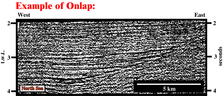
Fig. 2.2- Seismic lines can be interpreted in geological terms since we assume that seismic reflectors correspond, roughly, to chronostratigraphic lines, i.e., to stratal surfaces. On this North Sea seismic line, cratonic sediments are onlapping underlying type-rift basin sediments. The geometrical relationships between the seismic reflections define an onlap surface, which fossilizes the unconformity (erosional surface) between the rift-type and cratonic basin sediments. Taking into account the amplitude of the aggradation and encroachment of the onlapping sediments, the cratonic sediments seem to be deposited under significant water depth in association with gravity currents (turbidites).
"Toplap"
Termination of strata against an overlying surface. Toplaps occur along the upper interval boundary. The term toplap is used when it results of non-deposition process (sedimentary bypass) with only minor erosion. When this geometrical relationship is induce by erosion we will call it truncation.
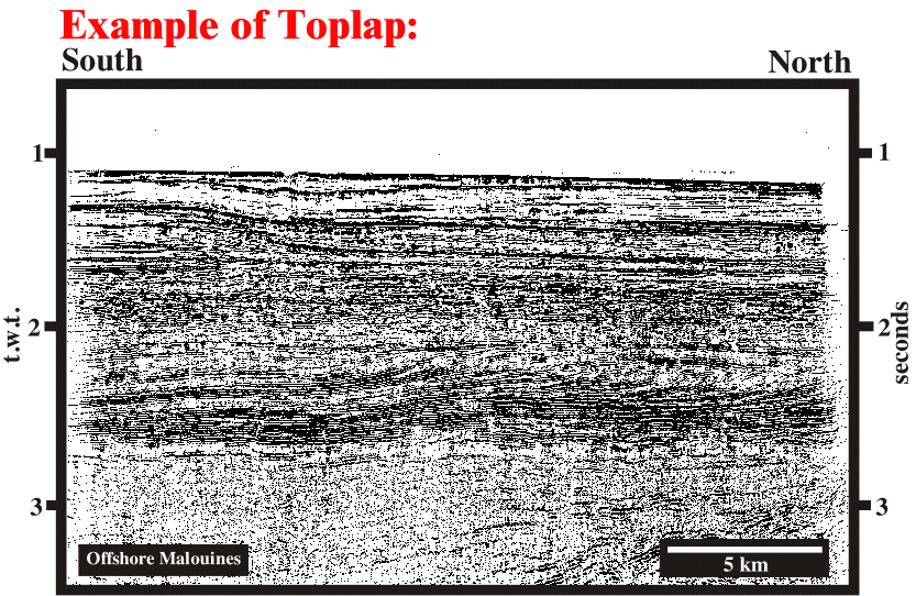
Fig. 2.3- On the right part of this seismic line, between 2.0 and 2.7 seconds, a progradational interval is, easily, recognized. This configuration is composed by a succession of seismic reflectors (chronostratigraphic lines) terminating against an overlying surface with minor erosion. Such a geometrical relationship, named toplap, indicates the associated strata lap out landward. Seaward, i.e., down-dip, the oblique reflectors flatten and become horizontal defining what geologists call an apparent downlap. The time difference between the toplap and the apparent downlap (roughly 0.2 milliseconds) suggests the oblique reflectors are associated with a deltaic slope, i.e., a prodelta.
Toplap implies that each strata laps out in a landward direction at the top of the unit and the successive terminations progress seaward. On contrary, truncated strata can lap out in any direction. In addition, down-dip of a toplap there is always a downlap or an apparent downlap. Toplap is mainly associated with coastal deposits.
Truncation:
Truncation (fig. 2.4) corresponds to a stratal termination or seismic reflection interpreted as strata, along an unconformity surface due to post-depositional erosional.
Truncation as toplap occurs along the upper interval boundary.
Truncation implies deposition of strata and their subsequent removal to form an unconformity surface.
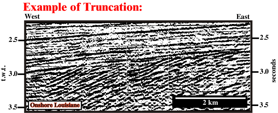
Fig.2.4- On this seismic line we can recognize two major intervals. The upper one is composed by parallel reflectors, slightly, tilted westward. The lower one is, also, composed by parallel reflectors, but they have a much higher westward dip. The strata associated with the lower interval were tilted and truncated. The time-gap between these two sedimentary intervals is an erosional hiatus.
"Downlap"
Downlap is a base discordant relation in which, initially, inclined strata terminated down-dip against an former horizontal or inclined surface (fig. 2.5).
A downlap geometrical relationship indicates the direction away from the source of clastic supply.
A seismic downlap is a downlap interpreted on a seismic section, i.e. a relation in which a seismic reflection interpreted as an initially inclined strata terminates down-dip against a reflection discontinuity interpreted as a former inclined or horizontal sedimentary discontinuity.
The sedimentary discontinuity can be:
- a flooding surface ;
- a complex transgressive backstepping surface ;
- an unconformity or
- para-conformity (conformity with an important hiatus).
There are two kind of apparent downlap:
(i) Those created by tectonics (particularly by halokinesis or shalokinesis).
- They correspond very often, to tilted onlap due the salt or shale flowage.
(ii) Those induced by seismic resolution.
- Seismic reflections, representing units of inclined or tangential strata, can terminate down-dip, but the strata themselves, actually, flatten and continue as units, which are so thin that they fall below the seismic resolution.
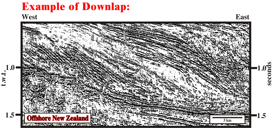
Fig. 2.5- On this seismic line, some oblique reflectors terminate in downlap and other in apparent downlap. These geometrical relationships indicate the seaward direction and, subsequently, the direction away from the source terrigeneous influx. On this example, these geometrical relationships are associated with the toe of continental slope progradations, since the amplitude of the oblique reflectors preclude deltaic deposits. The down-dip discontinuities are unconformities or their correlative conformities (sedimentary cycle boundaries).
Stratigraphic Surfaces & Stratigraphic Boundaries
A stratigraphic surface can be considered as a continuous physical boundary. At least three major groups of stratigraphic surfaces can be observed on the field or on seismic data:
a) Stratal Surface
Bedding planes and chronostratigraphic seismic reflectors are stratal surfaces.
- A seismic reflector represents a, more or less, thick sedimentary interval. The thickness of this interval depends on seismic resolution. It can ranges between 10 and 100 meters.
b) Discontinuity Surface
Discontinuity surfaces are physical surfaces caused by erosion or by non deposition.
They include:
(i) Unconformities;
They are caused by erosion induced by relative sea level fall.
(ii) Para conformities;
They separate parallel strata with an hiatus of non-deposition.
(iii) Depositional hiatuses;
They can be defined by:
a) Toplap / Downlap............................Sub-aerial / Sub-aqueous ;
b) Downlap / Apparent Truncation.........Sub-aqueous / Sub-aqueous ;
c) Onlap / Conformable......................Sub-aqueous / Sub-aqueous.
c) Diachronous Surface
In this group are included the retrogradational transgressive surfaces (backstepping) and, on seismic data, the reflectors associated with gas/oil-water plane contact ("bright-spots").
Stratigraphic boundary which separate rocks of significantly different environments or lithology, can be:
(i) Synchronous, i.e. parallel to stratal surfaces.
(ii) Diachronous, i.e. stepping across stratal surfaces.
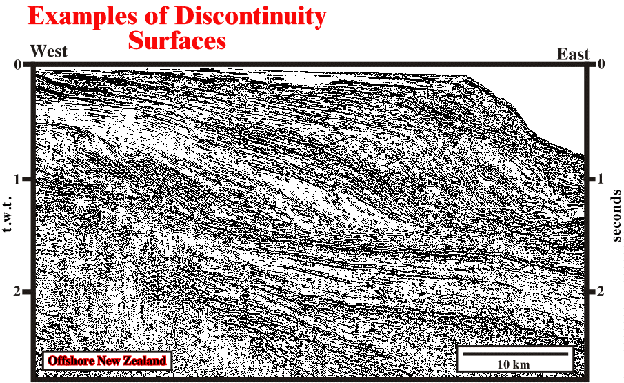
Fig. 2.6- On this line, all groups of discontinuity surfaces can be recognized: (i) unconformities, (ii) conformities and (iii) depositional hiatus. Try to recognize them and characterize them using geometrical relationships.
Unconformities
Unconformities are discontinuous stratigraphic surfaces.
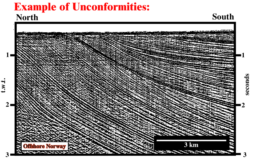
Fig. 2.7- On this seismic line several unconformities can be identified. They truncate the underlying sediments and they are fossilized by onlapping of the overlying strata. In addition, two major downlap surface are, easily, recognized.
Unconformities time-gaps may represent:
a) simply prolonged periods of sub-aerial exposures with minimal erosion, possibly with local valley or channel down-cutting,
b) periods of uplift and major sub-aerial erosion of strata,
c) submarine erosion by turbidites, slump or submarine currents.
Submarine erosion induced by gravity or turbidite currents is, generally, relatively local. The associated unconformities with such an erosion are, mainly, located in deep water environments (slope and abyssal plain). These unconformities do not have equivalent in shallow water environments. They are not boundaries stratigraphic cycles, but when the cycles are incomplete, i.e., just composed by deep water strata.
Uplift and Erosion are characterized by:
(i) Onlapping above the unconformity and (ii) Truncation below.
A valley or a channel are, also, characterized by:
(i) Onlap above the unconformity and (ii) Truncation below.
Very often, geologists confound valley with valley fill and channel with channel fill:
- A valley is a morphology which corresponds to any low-lying land bordered by higher ground.
- A valley fill or valley infilling is, a more or less, unconsolidated sediment, deposited by any agent, filling or partially filling a valley.
- A channel is the bed where a natural body of water flows or may flow.
- A channel fill or channel infilling is the strata deposited in a channel, particularly, in an abandoned cutoff channel or where the transporting capacity of the stream is insufficient to remove material supplied to it (Bates & Jackson, in Glossary of Geology, Second Edition, American Geological Institute, 1980).
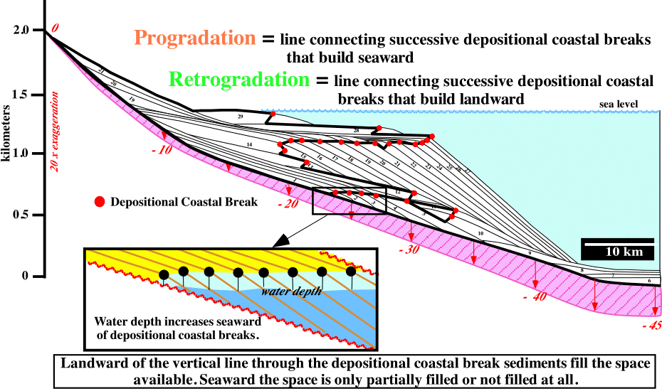
Fig. 2.8- The displacement of the depositional coastal break is, clearly, illustrated by the red dots. Relative sea level falls create downward and basinward shifts of the coastal break, which emphasize the unconformities bounding the sequence cycles. There are two basinward shifts of the coastal break: (i) between the chronostratigraphic lines 5 and 6, and between the lines 21 and 22.
The Depositional Coastal Break or Depositional Shoreline Break corresponds to the lower level of erosion of the waves when the sea is quite, i.e., around 10-20 meters below sea-level. The coastal break can correspond, also, to the shelf break (limit between the platform and the upper slope). Actually, at the end of a regression, the coastal and shelf breaks are coincident (the basin has no platform or no shelf). As early as a transgression takes place, the coastal break migrates landward creating a platform (shelf). The progressive backstepping of the coastal break increases the water depth of platform creating, at same time, starved conditions, on the distal area near the shelf break.
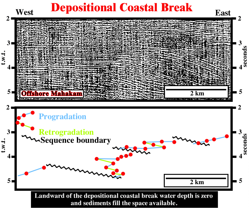
Fig. 2.9- On this seismic line of the offshore Kalimantan, between 3 and 5 seconds, the depositional coastal break and shelf break are, very often, coincident. This interval is, mainly, regressive. It has an internal forestepping geometry. Actually, the progradation (seaward displacement) of the depositional coastal break is not continuous. Three downward and basinward shifts of the shelf break, induced by relative sea-level falls, are, clearly, recognized. They characterize three unconformities. These unconformities are, mainly, induced by eustasy, since the geometry of the coastal plain is, roughly, horizontal. On the other hand, between each unconformity, the coastal break (= shelf break) shows progradational (in blue) and retrogradational (in green) displacements .
Landward of the depositional coastal break, all accommodation, i.e., all space available for the sediments, is filled. This means that a relative sea level rise of 15 meters, for instance, increases the accommodation of 15 meters and 15 meters of sediments will be deposited landward of the depositional coastal break. On the contrary, seaward of the depositional coastal break, the space available (accommodation) is, partly, filled or not filled at all.
A relative sea level rise of 20 meters, for instance, increases the shelfal accommodation (water depth) of 20 m. If 5 m of sediments are deposited seaward of the shelf break, the accommodation decreases of 5 meters. Seaward of the coastal break, the total accommodation (before deposition) is equal to the thickness of the deposited sediments plus the water depth. Do not forget that sedimentation occurs just during the stability period of the relative sea level that follows a marine ingression. During a relative sea level rise (marine ingression), the shoreline is displaced landward inducing a ravinement of sea floor, but without deposition. Shelfal deposition occurs when shoreline is displaced seaward, during a stable relative sea level, mainly due to an increasing of the terrigeneous influx (sedimentary regression). Seaward of the shelf break, the accommodation is big enough to allow sedimentation without relative sea level rise, i.e., sedimentation can occur even during relative sea-level fall (ex: turbidites).
Tectonic enhanced unconformities (angular unconformities) are, easily, recognized. However, the majority of the unconformities (induced by relative sea level falls) are cryptic, since landward of the shelf break and in the abyssal plain, the horizontal geometry of the seismic reflectors is not favorable to identify the unconformities. Downward and basinward shifts of the coastal break, is an important step to the identification of the unconformities.
Shortly, landward of the shelf break, the cryptic unconformities are, mainly, recognized by the evidence of the infilling of incised valleys. Around and seaward of the shelf break, they can be recognized due to the presence canyon fills and downward and basinward shifts.
Taking into account that landward of the depositional coastal break, which, as said before, can coincide with the shelf break (when the basin has no shelf), all accommodation is filled by sediments and the water depth is zero. Seaward of the coastal break, the paleo-water depth (paleo-bathymetry) along chronostratigraphic lines can be calculated using the coastal plain are datum.
..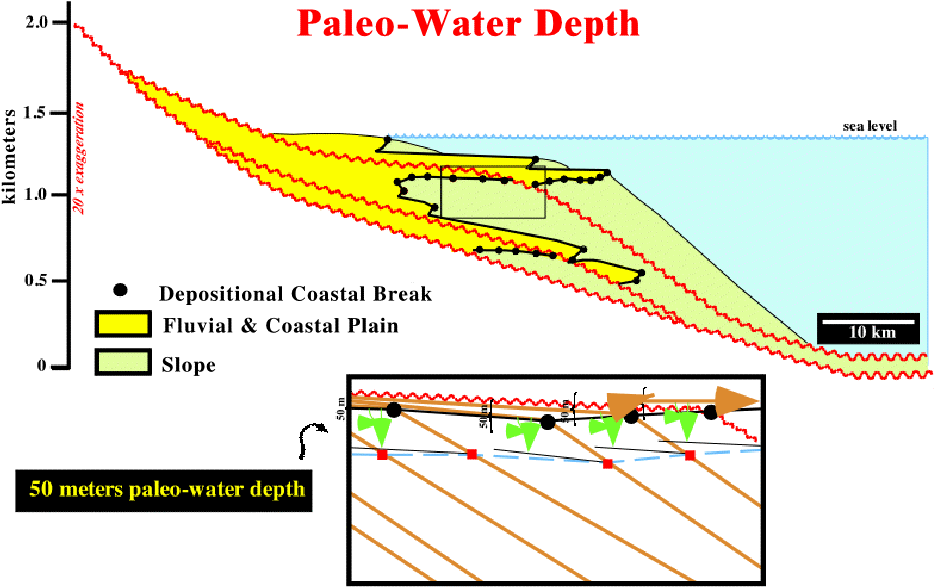
Fig. 2.10- On a chronostratigraphic line, generally, the proximal break marks the depositional coastal break whereas the distal indicates the toe of the continental slope. Landward of the shelf break, the water depth is zero. Taking the coastal plain as reference, it is possible to calculated the paleo-water depth seaward of the shelf break.
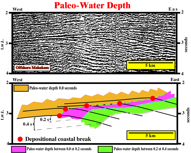
Fig. 2.11- On this seismic example, the paleo-water depth of the continental slope can be calculated (t.w.t.), since the depositional coastal break and the coastal plain are, easily, recognized. Two paleo-water depth, 0.2 and 0.4 seconds (t.w.t.) were calculated.
Accommodation is the space available for sediments. Generally, it reflects the space made available for sediment accumulation on the shelf (shelfal accommodation) through a combination of subsidence and sea level changes.
Whether this space is, entirely, filled or not depends on the rate of sediment supply to the basin and where the space available is related to the depositional coastal break.
The key to sequence stratigraphic interpretation lies in the application of the accommodation concept to the interpretation of depositional environments.
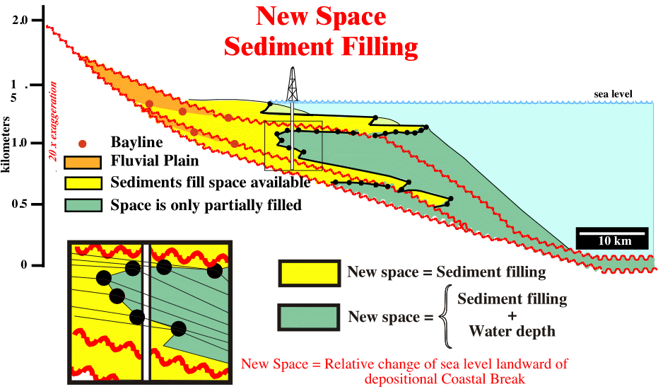
Fig. 2.12- Following a marine ingression, if the sediment supply is big enough, the new space available for sediments (accommodation) will be, completely, filled landward of the depositional shelf break. Seaward of the shelf break, the new space created by the relative sea level rise is equal to the thickness of the deposited sediments plus the water depth.
P. Vail identifies the variations in sedimentary accommodation in several steps:
1) Locate the marine shale wedge:
- In siliciclastic section this wedge, typically, occurs on the shelf, where it is overlain and underlain by coarser sediments and extents, laterally, into the slope and basin.
- In carbonate section, this wedge may be shales, marls or calcareous muds, and it is, typically, overlain by coarser clastic carbonates or by evaporites and underlain by transgressive carbonates.
2) In sediments deposited on the shelf, locate overall fining and thinning upward pattern at the base of the marine shale wedge:
- In siliciclastic they, often, form a bell shaped log pattern and reflect the retrogradation of successive para-sequences as rapid sea-level rises forces the shoreline away from the basin and across the shelf.
- In carbonates, these variations may be less visible on logs and may require sample and core studies to recognize the fining upward pattern and the increase in depositional water depth.
3) In sediments deposited on the shelf, locate the overall coarsening and thickening upward patterns at the top of the marine shale wedge:
- In siliciclastic they, often, forms a funnel shaped pattern at the top of the marine shale wedge, representing progressive progradation of delta-front sands, followed by deltaic and fluvial sand-shale sections representing decreasing marine conditions.
- Similar shallowing upwards facies pattern can be observed in carbonates trough core and sample studies, aided by biostratigraphy.
The bayline is the demarcation line between the areas characterized by sub-aerial and marine accommodation, i.e., between the alluvial plain and coastal plain or between fluvial and marine sediments (coastal plain sediments are considered as marin deposits).
)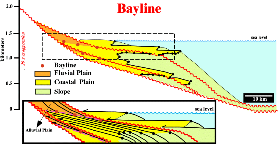
Fig. 2.12- In sequenttial stratigraphy , the bayline is the frontier between fluvial (alluvial plain) and marine sedimentation (coastal plain).
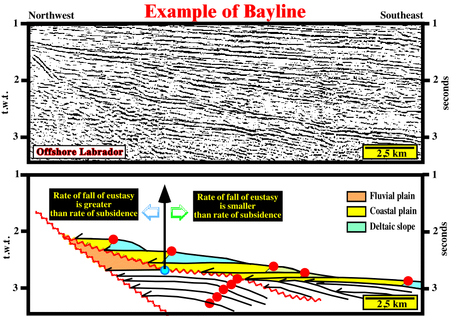
Fig. 2.13- The displacements of the depositional coastal break (red circles) are, easily, recognized. On the lower part of the section, the depositional coastal break coincide with the shelf break. On the upper part, following a relative sea level rise, the depositional coastal break is individualized from the shelf break and displaced, progressively, landward. The break on the unconformity (blue circle) which limits the regressive from the transgressive interval, is the bayline. Landward of the bayline line the rate of fall of the absolute sea level* is greater than the rate of subsidence, while seaward it is smaller.
* Sea level referenced to a fixed point, which is, generally, the Earth's center. It can rise or fall, mainly, function of the volume of the oceanic basins and volume of the ice sheets and ice caps (glaciers included). Notice, the water volume, under all its forms (solid, liquid and gaseous), is considered constant since the Earth's formation, around 4.5 Ga (109 years ago). Synonym with Eustatic Sea Level and, for certain geoscientists , with Eustasy,
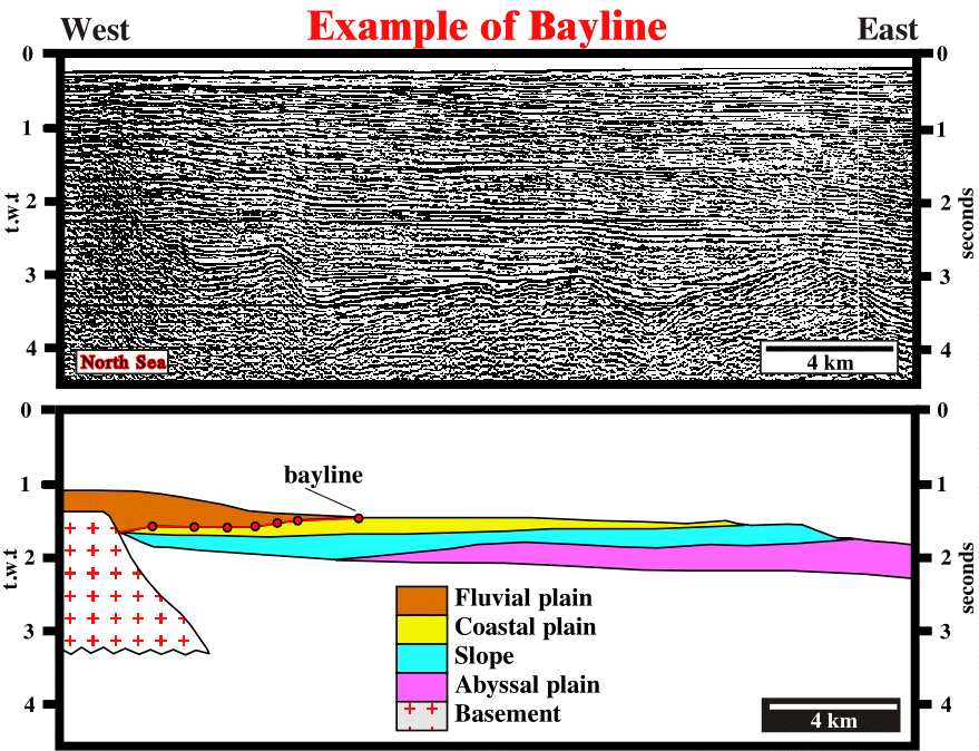
Fig. 2.13- On this North Sea seismic line, the displacements of the depositional coastal break are, easily, recognized. On the lower part of the section, the depositional coastal break coincide with the shelf break. On the upper part, following a relative sea level rise, the depositional coastal break is individualized from the shelf break and displaced, progressively, landward. The breaks on the successive chronostratigraphic lines (red circles), emphasize the changes between fluvial and coastal plain sediments, i.e., the successive baylines.
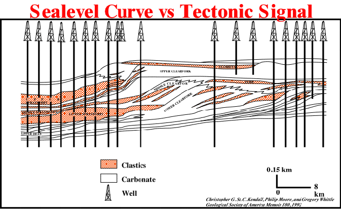
Sea-level Curve versus Tectonic Signal
Eustatic signals can be recognized as worldwide events. The amplitude of the events cannot be determined. However, assuming an eustatic sea-level behavior, the tectonic tectonic behavior can be predicted or vice-versa.
Fig. 2.14- Geological section used to test the role of the sea-level curve and the tectonic signal.
The simulations results highlight the importance of taking care in selecting the sea-level model to be used in the simulation. At the same time, it is critical that, once a sea-level model has been selected, no matter what that model, it must be used consistently from basin to basin. Such models can be used to maker extremely accurate predictions of sedimentary geometry.
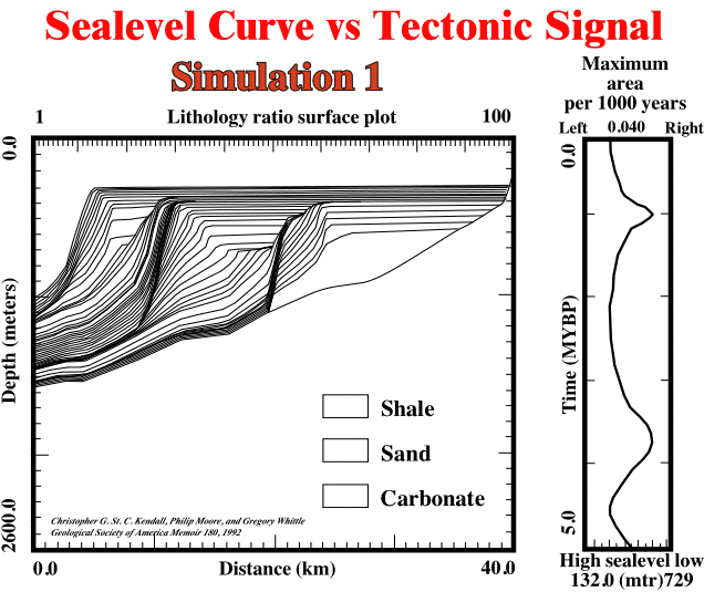
Fig. 2.15- Simulation avoiding tectonic signal (subsidence), only sea-level changes have been used for sedimentation.
Do not forget sea-level is only part of the accommodation for sedimentary fill, which depends, also, upon the residual of tectonics. The amplitude exhibited by sea-level events of Haq and others (1987) are undoubtedly model-dependent, and they may be very wrong or partly wrong.
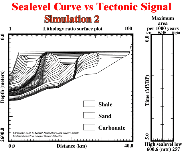
Fig. 2.15- Simulation avoiding eustatic sea-level, only the tectonic signal (subsidence) was used for sedimentation. This result is very similar to that obtain on simulation 1, in which just sea-level changes were used for sedimentation.
to continue press
next
![]()
Send E-mail to carloscramez@gmail.com or to carlos.cramez@bluewin.chwith questions or comments about these notes.
Copyright © 2001 CCramez
Last modification:
2022