Systemic Stratigraphy Seminar
The solutions proposed for each exercise are just tentative geological interpretation of the seismic line taking into account (i) the global and regional geological setting of the area where the seismic line was shot, (2) the geometrical relationships between the seismic reflectors and the surfaces defined by the reflections termination and (3) Signature in stratigraphic records (stratigraphic record) proposed by P. Vail and coauthors.
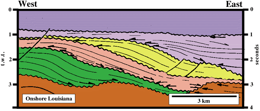
Exercise n°1
All geometrical relationships between the seismic reflectors terminations and seismic surfaces defined by them (unconformities or disconformities*) can be recognized on this seismic line. The geometrical relationships, as well as the internal configuration of the uppermost seismic intervals suggest a coastal environment with a meander belt. A point bar, the abandonment shales and the clay plugs are, clearly, depicted, but he geometrical relationships associated with them do not characterize unconformities (erosion and deposition are coeval). In other words, the associated discontinuities are not boundaries of stratigraphic cycles. An unconformity (characterized by truncation / downlap) is associated with the scoured surface of the meander. It represents an important erosional hiatus. Another unconformity (characterized by truncation) is recognized around 0.4 seconds depth (t.w.t.).
* When the strata or seismic reflectors are, more or less, parallel to the limit of a stratigraphic cycle or when there is no great evidence of a strata or reflections terminations against a limit of a stratigraphic cycle. In the field, an unconformity imply, necessarily, an erosion, which, in general, when small, is not visible in the seismic lines. A certain amount of erosion occurs at all stratigraphic cycle boundaries. The time intervals associated with an unconformity or with a disconformity may represent, more or less, prolonged periods of sub-aerial exposure with a minimum of erosion, as in incised valleys, which are, often, under seismic resolution.
Exercise n°2

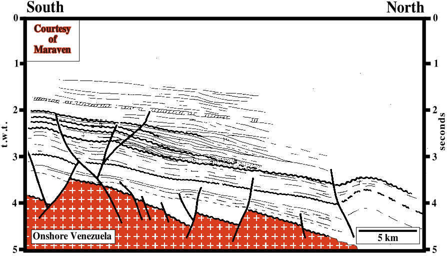
On this seismic line, shot in the foredeep basin of Perija, in Venezuela onshore, a major unconformity defined by truncation (below) and onlap (above). the Such unconformity corresponds to SB. 39.5 Ma, that is to say, to the stratigraphic cycle boundary of age 39.5 million years ago, which can be followed in all seismic lines of the area. This unconformity, which was, tectonically, enhanced (angular unconformity) can not be followed in continuity. Its interface, i.e., the associated acoustical impedance profile change laterally. Below this unconformity, a downlap surface (the reflection terminations are indicated by arrows) can, also, be identified. It indicates the more likely Cretaceous maximum flooding surface (MFS 91.5 Ma), which matches with the upper limit of the La Luna formation, where marine potential source rocks are likely. The strong markers overlying the toplaps of the progradations of the Colon formation (Upper Cretaceous) marks the upper Cretaceous unconformity (SB. 68 Ma). The compressional tectonic regime associated with the foredeep basin is responsible for the thrust faults visible on the left part of the line.
Exercise n°3
This seismic line comes from the same area of the previously one, i.e., from the foredeep basin of the Perija, in Venezuela onshore. This foredeep basin overlies a Mesozoic back-arc basin, which contains the major generating petroleum subsystem. The major unconformity corresponds to SB. 39.5 Ma, which is defined by truncation (below) and apparent downlap (above). The apparent downlap is a consequence of the sedimentary shortening associated with the foredeep basin. In fact, the observed downlaps can be interpreted as slightly inverted onlaps (tectonic inversion). Below the unconformity, the MFS. 91.5 Ma can only be recognized by the stratigraphic signature since geometrical relationships are indiscernible. However, the Colon formation (Upper Cretaceous) is, easily, identified not only by its strong amplitude boundaries, but its constant thickness (more or less isopachous) as well.
Exercise n°4
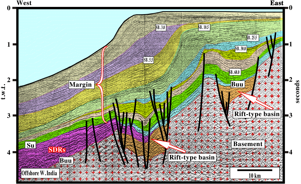
This seismic lines comes from Indonesia offshore (offshore north Java). It illustrates a back-arc basin without oceanization, that is to say, without break-up of the continental crustal and formation of a marginal sea (there is formation of a Non Atlantic-type divergent margin). This type of episutural sedimentary* basin is composed by two tectono-sedimentary basins: (i) Rift-type , associated with a rifting tectonic phase characterized by a differential subsidence and linked with the lengthening of the continental crust, and (ii) Cratonic basin developed during a sag phase created by regional subsidence. Several unconformities can be distinguished. They are generally characterized by truncation (below) an downlap (above) geometrical relationships. However, one of them was, locally, enhanced by the tectonic and became an angular unconformity. Near of the anticline structure, it is characterized by truncation (below) and concordant (above) geometrical relationships. Nevertheless, away from the apex of the anticline, the angularity of the unconformity diminishes gradually and it changes laterally to a cryptic unconformity (para-conformity). This tectonically enhanced unconformity or the cryptic unconformity dates the age of the tectonic inversion, which is one of the more characteristic features of this type of episutural basin.
*In the Bally and Snelson basins classification, episutural basins are thos which have developed within megasuture, such as Backarc and Non Atlantic-type Divergent Margins, associated with B-type subduction zones or Fold Belts, Mediterranean-Type and Pannonian-type basins associated with A-type subduction zones.
Exercise n°5
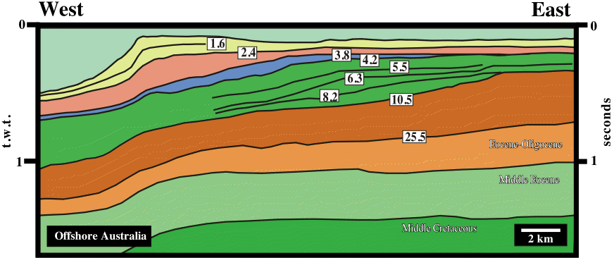
This seismic line from Australia offshore illustrates mainly the regressive phase of the Atlantic-type divergent margin, i.e. the uppermost phase of the post-Pangea continental encroachment cycle. The type-rift basins, which underlain the Atlantic-type margin are not visible. The margin itself, is composed by two sedimentary phases: (i) The transgressive phase characterized by an aggradational backstepping geometry and (ii) the regressive phase characterized by a progradational forestepping geometry. The limit between these two stratigraphic phase is the major Cretaceous downlap surface (MFS 91.5 Ma), which correspond to top of the dark green seismic interval (Middle Cretaceous). In the regressive phase, several major relative sea level falls can be identified by the seaward and downward shifts of the shelf break (when the basin has no self) or depositional coastal break (when the basin has a shelf). Taking into account the stratigraphic signature of the Australia offshore and its calibration proposed and tested by P. Vail, from top to bottom, it is possible to recognize the following unconformities: SB. 1.6 Ma, SB. 2.4 Ma, SB. 3.8 Ma, SB. 4.2 and SB. 5.5 Ma, in the Plio-Pleistocene, and SB. 6.3 Ma and SB. 8.2 Ma, in the Upper Miocene. Downward, the SB. 10.5 Ma and the SB. 25.5 can be identified.
Exercise n°6
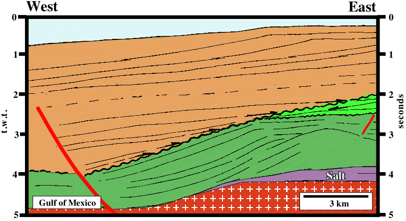
On this seismic line, all geometrical relationships are present. In addition, three major unconformities, with important erosional hiatus, can be identified. The downlaps, particularly those in the uppermost seismic interval, point out the direction of the terrigeneous influx (coming from east). In the second interval, defined by the unconformities (c, d), the chronostratigraphic lines were deformed by salt movements. i.e., the original onlaps became apparent downlaps, which do not give any information about the direction of sedimentary particles transportation. Actually, several geometrical relationships are, partially, deformed by halokinesis*. Salt fowage causes subsidence and increases, locally, the space available for sedimentation.
* Kind of salt tectonics in which the salt flows just due to its buoyancy, i.e., due to the release of the potential energy of gravity. Halokinesis is induced by the (lateral and vertical) flowage of evaporite levels, in the absence of any significant lateral tectonic stress, that is to say, in the absence of a compressive tectonic regime.
Exercise n°7
On this seismic line, all geometrical relationships are, easily, recognized. They characterize unconformities, downlap surfaces and detachment surfaces linked with a foredeep basin. Some of the unconformities are, predominantly, eustatic, whereas others are tectonically enhanced. The sediments were shortened by a compressive tectonic regime created by the tightening between two continental lithospheric plates which are part of a A-type subduction zone. On the upper part, the sedimentary shortening was done for the most part by thrust faults and associated cylindrical folds on the hanging-wall (up-thrown faulted block). An obvious detachment surface is recognized between 3.5 (right) and 5.6 seconds (left). It matches a tectonic disharmony, which separates undeformed (below) from deformed sediments (above). The age of the shortening is done by the age of onlap surface that fossilizes the shortened sediments.
Exercise n°8
This line illustrates the post-Pangea continental encroachment stratigraphic cycle in the west Australia offshore. This cycle is linked with the Meso-Cenozoic eustatic cycle induced by the breakup of Pangea and the ensuing drifting of the continents. Rift-type basins and an Atlantic-type divergent margin were formed. On the lower part of the line, a rift-type basin, bounded by two normal faults (picked in red) can be anticipated below 1.5 seconds. Upwards, in the non Atlantic-type divergent margin, two sedimentary phases were deposited: (i) The transgressive phase, with its backstepping geometry, and (ii) The regressive forestepping phase. Their internal configuration, clearly, indicates a continuous rise of the absolute sea level*, during the transgressive phase and a, progressively, eustatic fall during the regressive phase. The potential source rocks were deposited either in the rift-type basin or in association with the major downlap surface, which separates the two sedimentary phases. The organic matter of both potential source rocks seems immature.
*The absolute Sea level is referenced to a fixed point, which is, generally, the Earth's center. Assuming, the water volume, under all its forms (solid, liquid and gaseous) constant since the Earth's formation (around 4.5 Ga), The absolute sea level rises or falls, mainly, function of the volume of the oceanic basins, ice sheets and ice caps (glaciers included). The relative sea level, which is the result of the combined action of the absolute sea level (supposed global) and tectonics (subsidence or uplift of the sea floor), is referenced to any point on the land surface as the sea floor or the top of the continental crust (base of sediments).
Exercise n°9
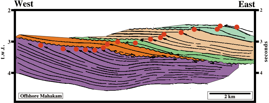
On this seismic line from the Kalimantan offshore (Indonesia), the progradation of the shelf break during the lower part of the non Atlantic-type divergent margin is, easily, followed. Five downward and basinward shifts of the shelf break bring to light five unconformities, i.e. five boundaries of stratigraphic cycles induced by 3rd order or higher eustatic cycles. The successive displacements of the shelf break indicates a predominant progradation versus aggradation. Such a geometry suggests a relative sea level, more or less, constant or a slow relative sea level rise. A high rate of sea level rise (fast increase of accommodation) favors aggradation, whereas a low rate of sea level rise (low increase of accommodation) favors progradation. The location of potential reservoirs is, partially, controlled by the ration progradation/aggradation.
Exercise n°10
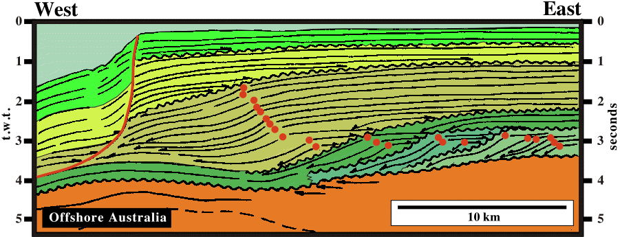
On this seismic line of the Australia offshore, it is easy to follow the successive displacements of the shelf breaks,during the regressive phase of the post-Pangea continental encroachment stratigraphic cycle. Seismically speaking, i.e., taking into account the seismic resolution, during this phase, the shelf breaks are, roughly, coincident with the depositional coastal breaks (absence of self deposits). The displacement of the shelf breaks is, mainly, progradational (if there are landward displacement of the depositional coastal break they are under seismic resolution). The major unconformities are, easily, recognized by downward and basinward shifts of the shelf break. In the lower section of the regressive phase, just above the major downlap surface, the rate of relative sea level fall is, more or less, constant. Outbuilding is much more striking than upbuilding. On the contrary, above the progradation / aggradation ratio suggests a faster relative sea level rise (progradation follows a steep path).
Exercise n°11
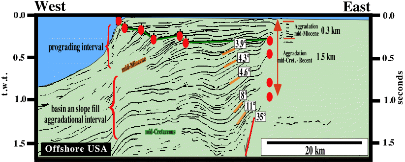
This seismic line is representative of the Meso-Cenozoic Atlantic-type divergent margin of East of USA. From bottom to top, we can recognize an aggradational interval deposited during the transgressive phase of the continental encroachment stratigraphic cycle, and a progradational interval deposited during the regressive phase. The aggradational phase highlights a period of absolute sea level fall, while the regressive phase marks a falling period of the absolute sea level*. The amplitude of the dips of the slope progradations suggests a carbonaceous facies. In the upper part of the line, during the Upper Miocene, the position of the successive shelf break can be followed without major difficulty. The progradation / aggradation ratio suggests an higher rate of sea level rise during the Mesozoic than during the Cenozoic.
*In sequential stratigraphy it is fundamental not to confuse the relative sea level with absolute (eustatic) sea level. The first is a local sea level, referenced to any fixed point on the Earth's surface, which can be the base of the sediments (top of continental crust) or the sea floor. The second is the sea level, supposed to be global, referenced to the Earth's center. The relative sea level is the result of the combined action of absolute (eustatic) sea level and tectonics (subsidence or uplift of the sea floor). The absolute sea level is the result of the combination of: i) Tectono-Eustasy that is controlled by the volume variation of the ocean basins in association with oceanic expansion following the rupture of the supercontinents ; (ii) Glacio-Eustasy, which is controlled by the variation of water volume of the oceans as a function of the amount of ice (assuming that the amount of water in all its forms is constant since the formation of the Earth (around 4.5 Ga) ; (iii) Geoidal-Eustasy which is controlled by the distribution of ocean water caused by variations in the Earth's gravity field (where gravity is stronger than normal, sea level is thrown to the center of the Earth) and (iv) Steric rise of sea level or thermal expansion of the oceans (if the temperature increases, the density of the water decreases, and for a constant mass, the volume increases). During a given geological time, the combination of the eustatic curve (curve absolute sea level changes) and the tectonic (subsidence, when the predominant tectonic regime is in extensional or uplift, when the predominant tectonic regime is of compressional) gives the curve of the relative sea level change rate.
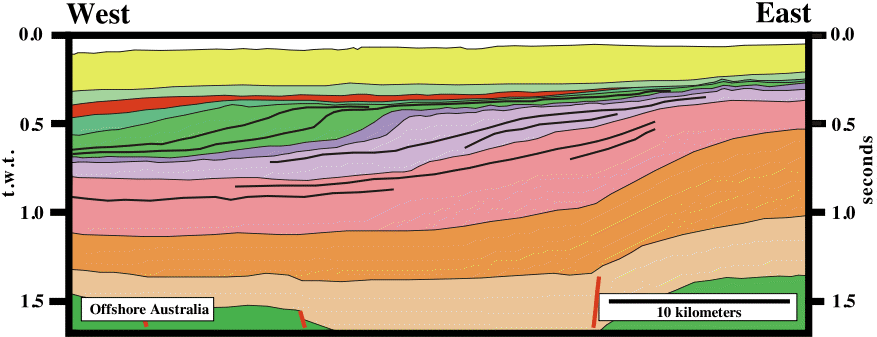
Exercise n°12
This tentative interpretation illustrates, in the middle section of the seismic line, how the picking of the geometrical relationships (reflection terminations), in the Mediterranean-type basin (Gulf of Mexico), allows to recognize three unconformities bounding two stratigraphic cycles. Within each stratigraphic cycle, which, probably, correspond to continental encroachment sub-cycles*, two downlap surfaces are, easily, recognized. In the light green interval, the downlap surface (MFS. 91.5 Ma) indicates the more likely location of the potential marine source rocks whose organic matter is, probably, immature on the right part of the line. In western section of each stratigraphic cycles, deep water environments are likely, seaward of the successive shelf breaks, were the onlapping fill geometry of the seismic markers is linked with the deposition of submarine slope and basin floor fans.
*The hierarchy of stratigraphic cycles depends on the order of the eustatic cycles, which induced them. In general, in seismic stratigraphy, made from seismic data (taking into account the seismic resolution), three main stratigraphic cycles are considered, which are deposited during 1st, 2nd and 3rdorder eustatic cycles, that is, eustatic cycles with time-durations, respectively, greater than 50 My (1storder), between 50 and 3-5 My (2nd order), between 3-5 and 0.5 My (3rd order): (i) Continental Encroachment Cycle ; (ii) Continental Encroachment Sub-cycle ; (iii) Sequence-Cycle and High Frequency Cycles. Continental encroachment cycles are associated with the break-up of supercontinents. Continental encroachments Sub-cycles are associated with changes in velocity of tectonic subsidence. Sequence-Cycles are associated with relative sea level changes, in which glacio-eustasy plays an important role. Sequence-cycles are the building blocks of sequential stratigraphy. It is from the study of the sequence-cycles, which are composed of different groups and subgroups sedimentary systems tracts, that lithological predictions can be advanced. Sequence-paracycles that form a sequence-cycle are not stratigraphic cycles, since there is no relative sea level fall between them (they are bounded by flooding surfaces).
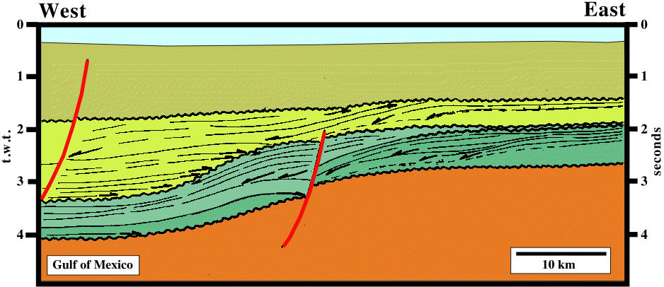
Exercise n°13
This seismic lines is located near frontier between Alabama offshore and Gulf of Mexico. A Mesozoic Mediterranean type-basin is, easily, identified. In fact, it seems that the lengthening of the substratum (Paleozoic fold belt) was big enough to breakup the continental crust and create a marginal sea above new oceanic crust. At the base of this basin, a salt layer and a Jurassic reef buildup located near the shelf break, can be recognized. A major downlap surface (interface between the green colors) separates the transgressive backstepping phase from the overlying Upper Cretaceous regressive forestepping phase. Seaward, the Upper Cretaceous sediments are too condensed to be recognized on seismic data. The more likely marine potential source rocks are closely connected with this downlap surface.
Exercise n°14
The spatial and temporal distribution of the geometrical relationships strongly suggest deepwater environment within the major stratigraphic interval, which is bounded by two unconformities. The geometrical relationships allow the individualization of three internal configurations. The lower one (colored in yellow), has a more or less parallel configuration, suggesting an onlapping fill by submarine basin floor fans. The middle one (colored in blue), has a hummocky or wavy configuration, which suggests a slope fan deposition make up by a stacking of channel-leveed complexes. The upper one (colored in violet) has a progradational configuration which characterizes a lowstand prograding wedge. This trilogy compose the lowstand interval of a stratigraphic cycle associated with an eustatic cycle of 3rdorder, i.e. a eustatic cycle with a time duration between 0.5 and 3-5 M years.
Exercise n°15
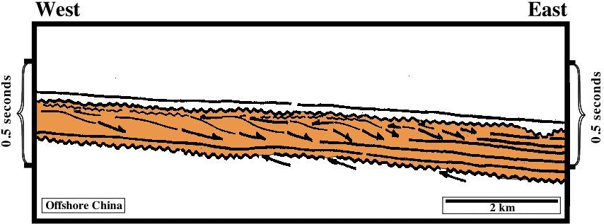
This seismic line from China offshore illustrates deltaic progradations within the regressive phase of the post-Pangea continental encroachment cycle of the non Atlantic divergent margin of East China. Actually, within a more or less isopachous interval which thickness is not higher than 0.25 seconds (t.w.t.) depositional coastal breaks can be individualized on the chronostratigraphic lines. This interval is bounded by two unconformities. The lower one is, easily, identified by truncation (below) and concordance (above). The upper one is a cryptic unconformity, in which, the associated erosion is just recognized by the identification a related incised valleys. The amplitude of the progradations (clinoforms), strongly, suggest a deltaic environment, i.e., a prodelta. Toplaps are associated with a minor erosion, which means the hiatus is, mainly, non-depositional. At the toe of the clinoforms proximal turbidites were, probably, deposited.
Exercise n°16
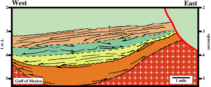
This seismic line from Gulf of Mexico illustrates the weight of salt tectonics on deformation of original geometrical relationships. Actually, the original onlaps were, completely, tilted and became apparent downlaps. The reason of such a deformation was the complete lateral salt flowage, i.e. the development of a salt weld, which is responsible of the depocenter visible on right end of the profile. The salt flowage explain also the apparent toplap, that we can recognize on the upper part of seismic interval (yellow) below the unconformity. Just above the unconformity, retrogradational (backstepping) seismic markers point out the location of the more likely potential marine source rocks.
Exercise n°17
On this seismic line the influence of the salt tectonic on deformation of the original geometrical relationships is clearly denoted. Original onlaps became progressively apparent downlap as the salt withdraw. In this sense, the westward thickening of the green stratigraphic interval, i.e., in opposite direction of the salt flowage, is meaningful. The salt withdraw created a confined accommodation which gave birth not only to the depocenter on the right end of the line, but to the yellow depocenter as well. All unconformities, but the upper one, were deformed by the salt movements (halokinesis). All observed tectonic inversions are extensional and associated with the salt tectonics.
Exercise n°18
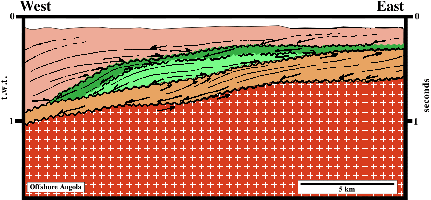
This seismic line characterizes the proximal area of the Angola offshore, nearby the Ambriz structural high. Around 10 kilometers landward of the end of this line the basement outcrops. The geometrical relationships and the internal configuration of the lowermost stratigraphic interval strongly suggests a salt weld at its base. We can say the geometrical relationships linked to this interval were deformed by the flowage of the evaporites which were, initially, underlying. The green intervals represent the transgressive phase of the post-Pangea continental encroachment cycle. However, their retrogradational geometry is not too obvious. On the contrary, the progradational or forestepping geometry of the sediments linked to the regressive phase is easily recognized, as well as the basal deep water sediments. The occurrence of an onlap filling geometry downward and basinward of the progradation geometry, shows the importance of the by-pass geological event during the regressive phase.
Exercise n°19
This seismic line, clearly, illustrates the compressional tectonic regime of a back-arc basins. Actually, on these episutural basins, located within a megasuture (in this case the Meso-Cenozoic megasuture*), the compressional tectonic regimes are predominant. Taking into account the tectonic inversions, the majority of the geometrical relationships are deformed and some of them are apparent. The major unconformities are angular, i.e., tectonically enhanced or reinforced, and the erosional hiatuses are consequential. They suggest the shortening of the sediments was not a single and instantaneous tectonic episode, but a continuous event with several paroxysmal phases. The last paroxysmal phase can be, roughly, dated by the age of the overlying sediments. It is important to note the age of an unconformity is given by the age of the linked basin floor fans, i.e., where the hiatus is minor. The normal faults, bordering the rift-type basins, created during the rifting phase of the backarc basin, were reactivated with a reverse movement during the compressional regimes. The tectonic inversion was big enough to fully change the old geometry of the normal faults. In fact, any null point is discernible along the fault planes.
* Earth's mobile region (folded and faulted mountain ranges), which testifies to the complexity of the accretion and deformation phases undergone by geological bodies in regions where compressional tectonic regimes predominate. The term megasuture was first used in 1975 by A. Bally. Although the compressional tectonic regimes associated with the subduction zones are predominant in the formation of a megasuture, extensional regimes and the formation of sedimentary basins play, also, an important role.
Exercise n°20
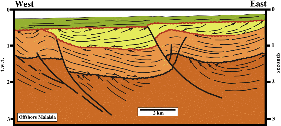
The sedimentary shortening of the SE Asia backarc basins is, clearly, illustrated on this line. The shortening is, here, done by thrust-faults with opposite vergence which create typical "fish tail" structure or triangular zones, which favoured by the presence of detachment levels. In fact, the majority of the thrust-faults match, very often, with over-pressure horizons, which act as decollement surfaces. It is important to note that the basement not involved. One of the characteristics of this style of shortening is the simplicity of superficial structures and the complexity of the deeper structures. Actually, on this line, in surface, the shortening was done by a nice symmetric cylindrical anticline with linked uplift, whereas in depth, due to volume problems, it can just be effective by reverse faulting and detachment above an infrastructure or the basement.
Exercise n°21
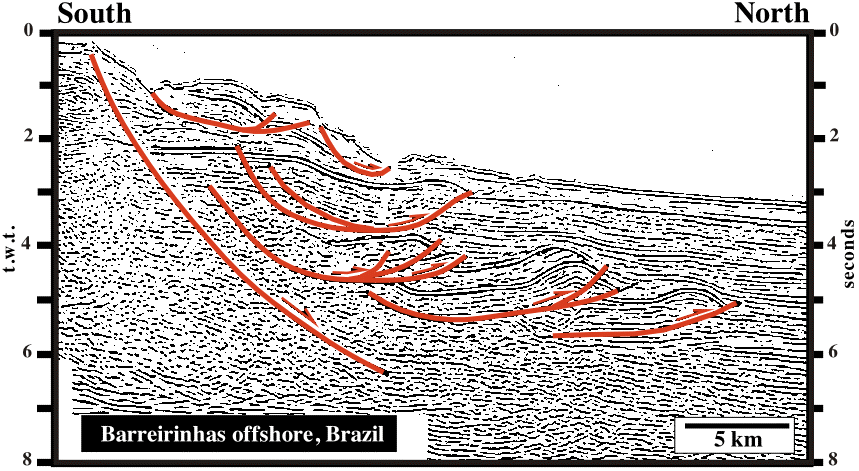
On this line from the north Brazil offshore (Barreirinhas geographic basin*), are illustrated confined compressional structures developed on the upper-middle continental slope. This structures are associated with a compressional tectonic regime created as a response to the extensional regime developed up-dip. In fact, the faults are listric, i.e., they have a normal movement up-dip and a reverse down-dip; their movement is similar to the movement of a shovel (listron in Greek).
*Contrarily to a sedimentary basin, a geographic basin has no geological meaning. A geographic basin is a pure administrative division of an onshore or offshore, in which sedimentary basins were deposited over time. The Kwanza geographic basin, for instance, is just the area, in the Angola onshore (crossed by the Kwanza river), where a stacking of different sedimentary basins (Paleozoic folded belt, Late Jurassic / Early Cretaceous rift-type basins and a Meso-Cenozoic divergent continental margin) were deposited. The use of geographic basins, such as Lusitanian Basin, Paris Basin, Neuquén Basin, Congo basin, etc., can be, easily, replaced by the temporal and spatial sedimentary basins of the Bally and Snelson's classification composing them.
Exercise n°22
This line illustrates the foredeep basin of Maturin (onshore Venezuela). Above a Paleozoic or a Precambrian substratum, it is easy to recognize: (i) Several rift-type basin, (ii) An Atlantic-type divergent margin and (iii) A foredeep basin. In the beginning, during the type-rift basins, the subsidence was differential, then, during the Atlantic-type divergent margin, development, it was thermal, and finally, during the foredeep basin (upper most area), the subsidence was flexural. In the margin still is possible to identify the aggradational, backstepping, transgressive phase, and the forestepping, progradational regressive phase. The famous source rocks of Venezuela, i.e., La Luna formation, are linked to the maximum flooding surface of Middle Cretaceous (MFS 91.5 Ma), which separates the transgressive and the regressive phases. This MFS is, easily, recognized by the abrupt change in geometry of the chronostratigraphic lines.
![]()
Send E-mail to carloscramez@gmail.com or to carlos.cramez@bluewin.chwith questions or comments about these notes.
Copyright © 2001 CCramez
Last modification:
2022