The regional seismic line (fig. 4), illustrates the Meso-Cenozoic foredeep basin of onshore Alaska, i.e. the Colville depression. Two major downlap surfaces with opposite vergences are, easily, recognized. The progradations associated with the lower downlap surface are looking southward, while the progradations associated with the upper downlap surface are looking northward.
This double vergence, strongly, suggests that the onshore Alaska and, particularly, the Colville depression correspond to the closing of an ocean, i.e., to the final step of Wilson’s tectonic cycle (fig. 5). According J. Tuzo Wilson, each orogenic cycle (fig. 5) starts with the lengthening of a lithospheric plate, probably, in response to one or several mantle plumes. In a first step, the lengthening creates rift-type basins within the continental crust. However, when the thickness of the lithosphere reaches 15-20 km, it breaks, individualizing two new lithospheric plates.
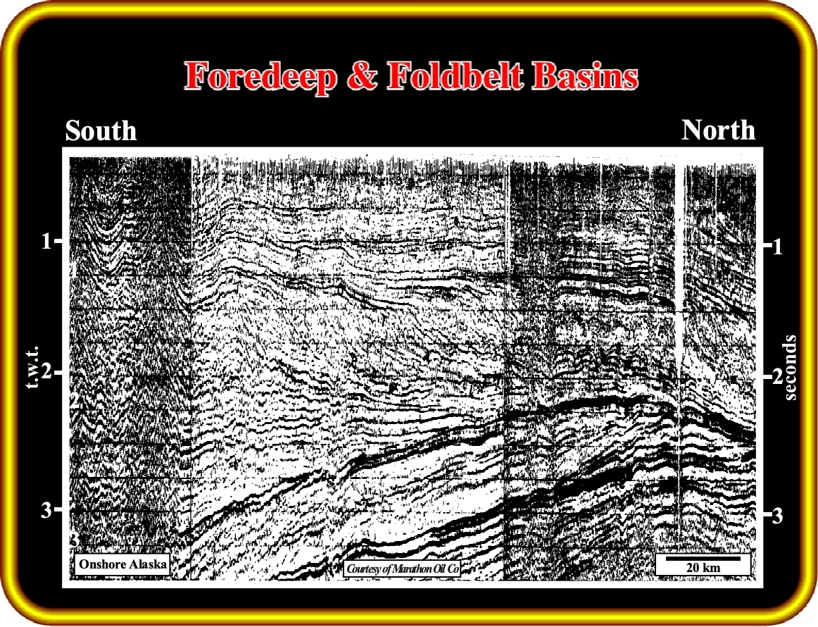
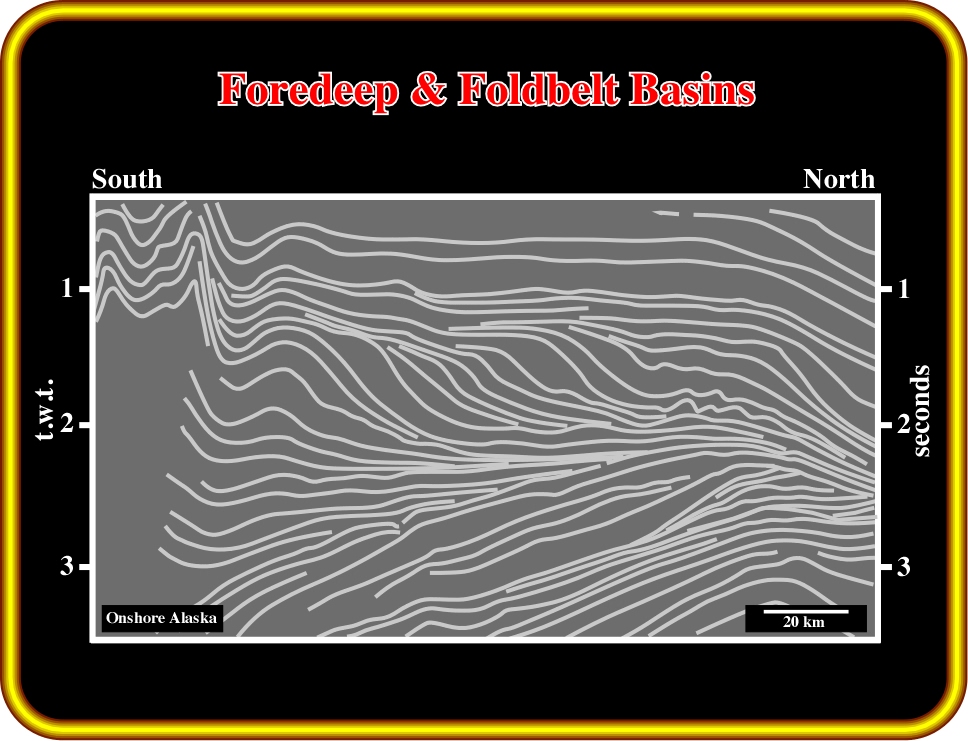
Fig. 4- This regional seismic line from the North Slope illustrates the Brooks fold belt (South), the Collville foredeep basin (middle) and the proximal section of the Nuwuk continental divergent margin (North). The foldbelt is associated with a compressional tectonic regime, while the other basins are associated with extensional tectonic regimes. The foredeep basin was, mechanically, driven (by thrust loading), while the Atlantic-type divergent margin was created, mainly, by thermal subsidence. The flexural bulge between the foredeep basin and the margin, i.e., the Barrow arch is, easily, recognized.
The break-up of the lithosphere allows the onset of volcanic expansion (sub-aerial and oceanic) and the birth of an ocean. Then, as the oceanic expansion and growth of the new ocean go on, an Atlantic -type divergent margin is developed on the edge of each lithospheric plate.
Each Atlantic-type divergent margin is composed of two sedimentary phases. At the bottom, the transgressive or backstepping phase and, at the top, the regressive or forestepping phase. The lower phase is induced by the sea-level rise created by sea-floor spreading (volume reduction of the oceanic basin due to the emplacement of the oceanic mountains, i.e. oceanic ridges). The upper phase is associated with the sea-level fall, due to the increasing volume of ocean basin induced by subduction and “collision“ events.
With time, the oceanic crust cools and becomes denser. Sooner or later, the oldest oceanic crust dives under the continental crust, which, having a sialic composition, is much lighter. Such a geological diving, labeled Benioff or B-subduction, individualizes a new lithospheric plate bounded by the mid-oceanic ridge and the B-subduction.
From then on, the margin, or margins (if the subduction of the oceanic crust occurs on each side of the ocean) no longer are divergent, but convergent. The most frequent case is illustrated in fig. 4, where only one margin becomes convergent (3 lithospheric plates). When the subduction rate of the continental crust along a Benioff zone is higher than the rate of oceanic expansion, the oceanic crust between the two continents will disappear, as well as, the ocean. The new lithospheric plate bounded by the B-subduction and the mid-oceanic ridge (oceanic expansion center) is consumed along the Benioff zone and disappears. Then, all oceanic crust of the divergent margin will be also consumed until total closure of the ocean.
The final result is the “collision” between two continental crusts and the formation of an orogen (9), as well as the gathering of all lithospheric plates. Such a “collision”, strongly, shortens the margin sediments by folding and thrusting, in order to satisfy the new volume conditions. The tectonic movement is mainly upward (σ3vertical), i.e., an important uplift takes place.
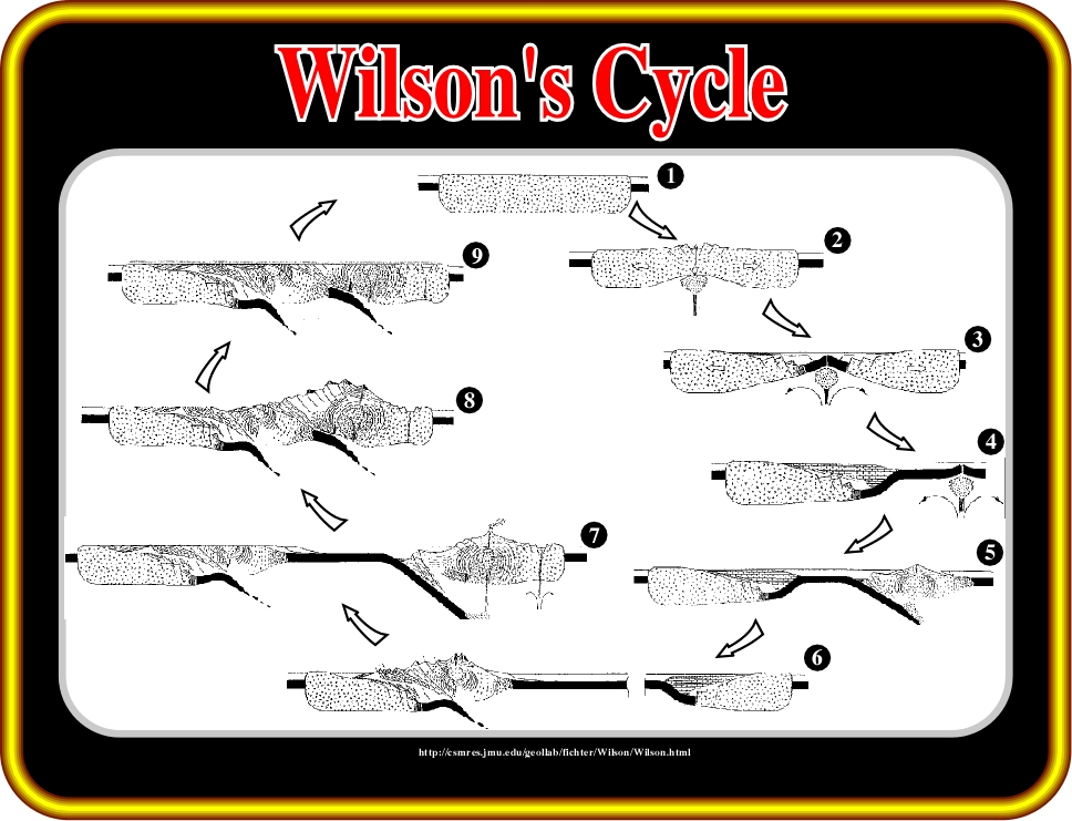
Fig. 5- Wilson’s tectonic cycle sketched on this figure, illustrates the formation of an orogen by “collision” between two continental lithospheric plates. The cycle starts by lengthening of a lithospheric plate and the creation of rift-type basins within the continental crust. Continuation of the lengthening breaks up the lithosphere, which initiates an oceanic expansion of the new individualized plates and the birth of an ocean. As sea floor spreading progresses, divergent continental margins are developed on each side of the new lithospheric plates. Then, due to cooling and aging of the oceanic crust, a B-subduction zone (Benioff) is formed along the shelf break of one margin, the ocean starts to shrink. Inexorably, the continuation of subduction brings to “collision (8)” the continental crust of the plates creating what geologist, generally, name a collisional orogen. This evolution can sub-divided into the following steps:(1) Stable craton, (2) Thermal anomaly and Rifting, (3) New oceanic crust, Young Divergent Margin, (4) Old Divergent margin, (5) Convergent Margin: Uplift associated with a Volcanic Arc, (6) Collision between the Margin and the volcanic arc with formation of a Fold Belt, (7) Peneplantion of the Fold Belt, (8) Collision continent-continent, (9) Stable Craton.
(9) At several times, Goguel points out that kinetic energy plays no role in continental collision. The collision between two continents does not correspond to the transformation of kinetic energy into deformation energy, as is the case in the collision between two buses.
Let’s return to the regional seismic line of onshore Alaska illustrated in fig. 4. On this seismic line, it is easy to recognize several sedimentary basin types and in particular the Colville foredeep basin (fig. 6). This basin like other foredeep basins, such as Powder River (USA), Alberta (Canada), Po (Italy), Maturin (Venezuela), etc., is considered a typical foredeep basin by the majority of explorationists, since it is mechanically and not thermally induced. Stratigraphic, seismic, gravimetric and palinspastic studies indicated that in the Colville foredeep basin, the substratum dips towards the associated fold belt, i.e. the Brooks Range (fig.7).
Initially, the Jurassic continental margin seems to have been developed on the northern area:
- The Endicott and Lisburne Groups can be interpreted as sediments deposited in pre-Cretaceous rift-type basins underlying a Jurassic divergent margin.
- Sadlerochit Group and Sag River represent basal sediments of the margin and the overlying transgressive sedimentary phase.
- The Kingak Shales correspond to the regressive stratigraphic phase of the divergent margin.
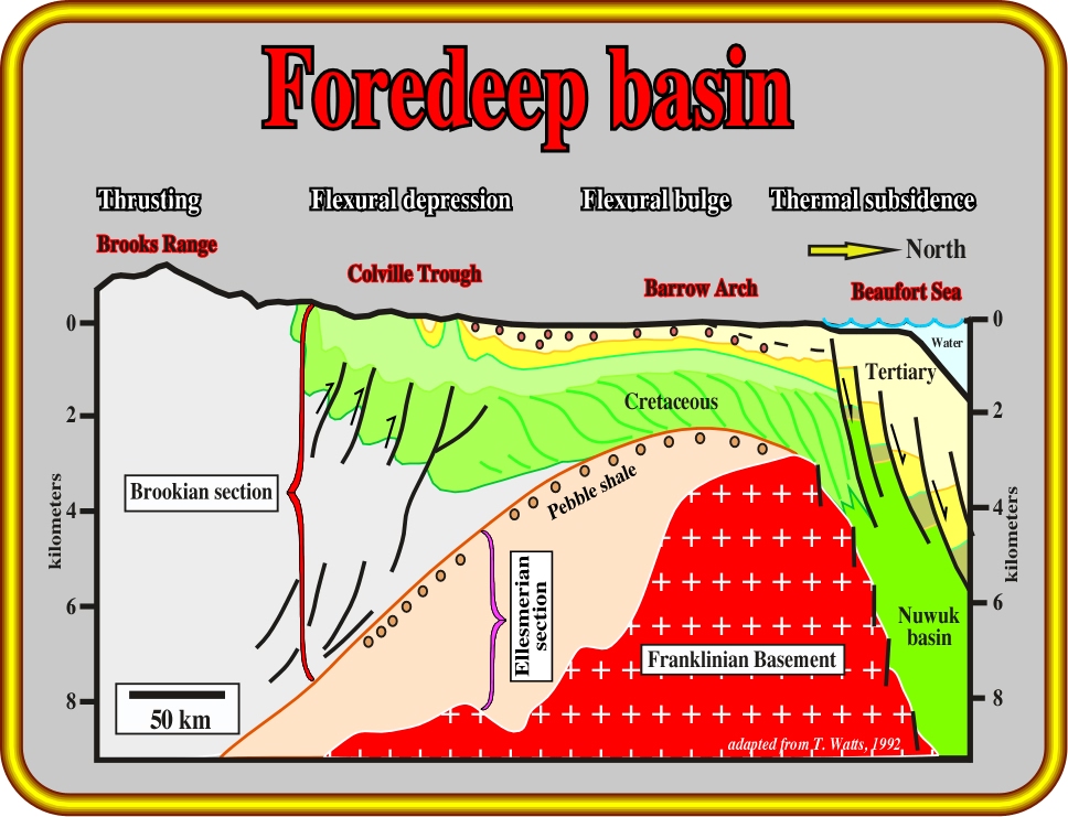
Fig. 6- Schematic cross-section through Brooks Range, Colville trough, Barrow Arch and Nuwuk basin. The majority of geologists take the Brookian section as a typical foredeep stratigraphic interval. Landward of the flexural bulge (Barrow arch) is located the flexural depression (Colville trough), which marks the flexural subsidence. Seaward of the Barrow arch is the Nuwuk basin, which corresponds to a continental divergent margin created by thermal subsidence. The Pebble formation emphasizes the onset of the flexural subsidence induced by thrust loading.
The progradations of the Kingak slope shales indicate that at the end of the Jurassic time the continent was northward and the ocean southward, where the ancestral Brooks Range started rising.
- The uplift and northward progradation of the Brooks Range progressively reduced the ocean’s extent, preserving the basal foredeep unconformity.
- Actually, deep water sediments of the Toro Formation downlap on the pebble sand unit of the Kingak shale formation, tilting the deposited sediments southward.
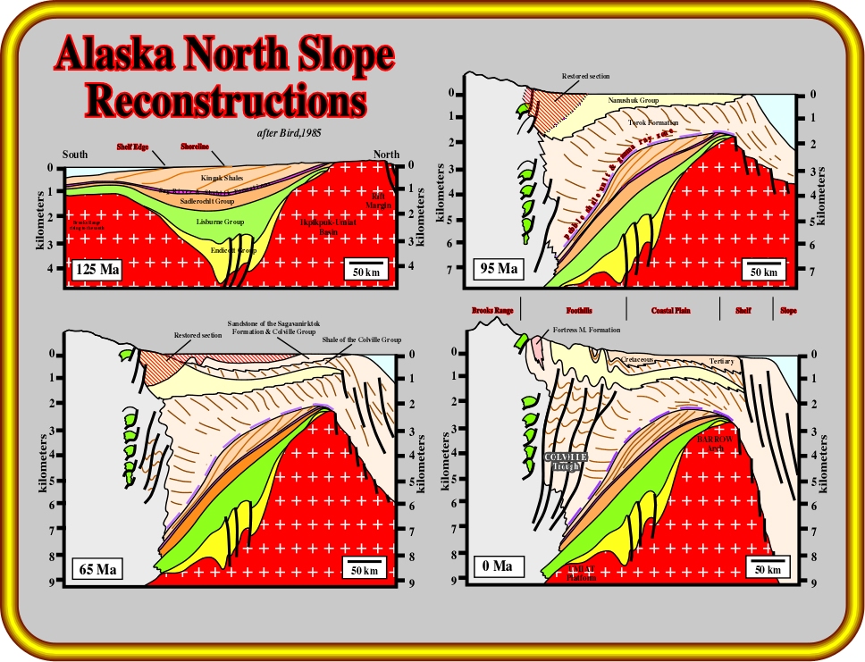
Fig. 7- On this North-South cross section and reconstructions across the Alaska North Slope, it is interesting to note : (i) The basal foredeep unconformity overlying the Kingak Formation, (ii) the sub-horizontal onlap of presumed deep-water shales on the down-dip extension of that unconformity, (iii) the up-dip truncation of the unconformity related to the cessation of rifting on the divergent margin of northern Alaska, and (iv) the southerly progradation of the Kingak Formation, which contrasts with the northeast progradation of the overlying foredeep clastics (A. Bally, 1989).
All stratigraphic, seismic, gravimetric and other studies indicate the substratum of foredeep basins dips toward the associated fold belt. In the Colville foredeep basin (figs. 5 & 6), which is one of the most prolific basins in the world:
- The substratum is limited to the area between the fold belt and the Barrow structural arch, and it dips toward the Brooks fold belt.
As will be seen in the addendum, a geological model in which an elastic lithospheric plate is overloaded easily explains the flexural geometry of the substratum on one of its ends.
to continue press

Send E-mails to carloscramez@gmail.com or to carlos.cramez@bluewin.ch with comments and suggestions to improve site.
Copyright © 2003 Ccramez, Switzerland
Last updated: August, 2014