
II- Total SA's Hypothesis
This hypothesis, proposed by Total's geoscientists, in 2000, is a tentative explanation of the opening of South Atlantic, which can be depicted by the following sketches:
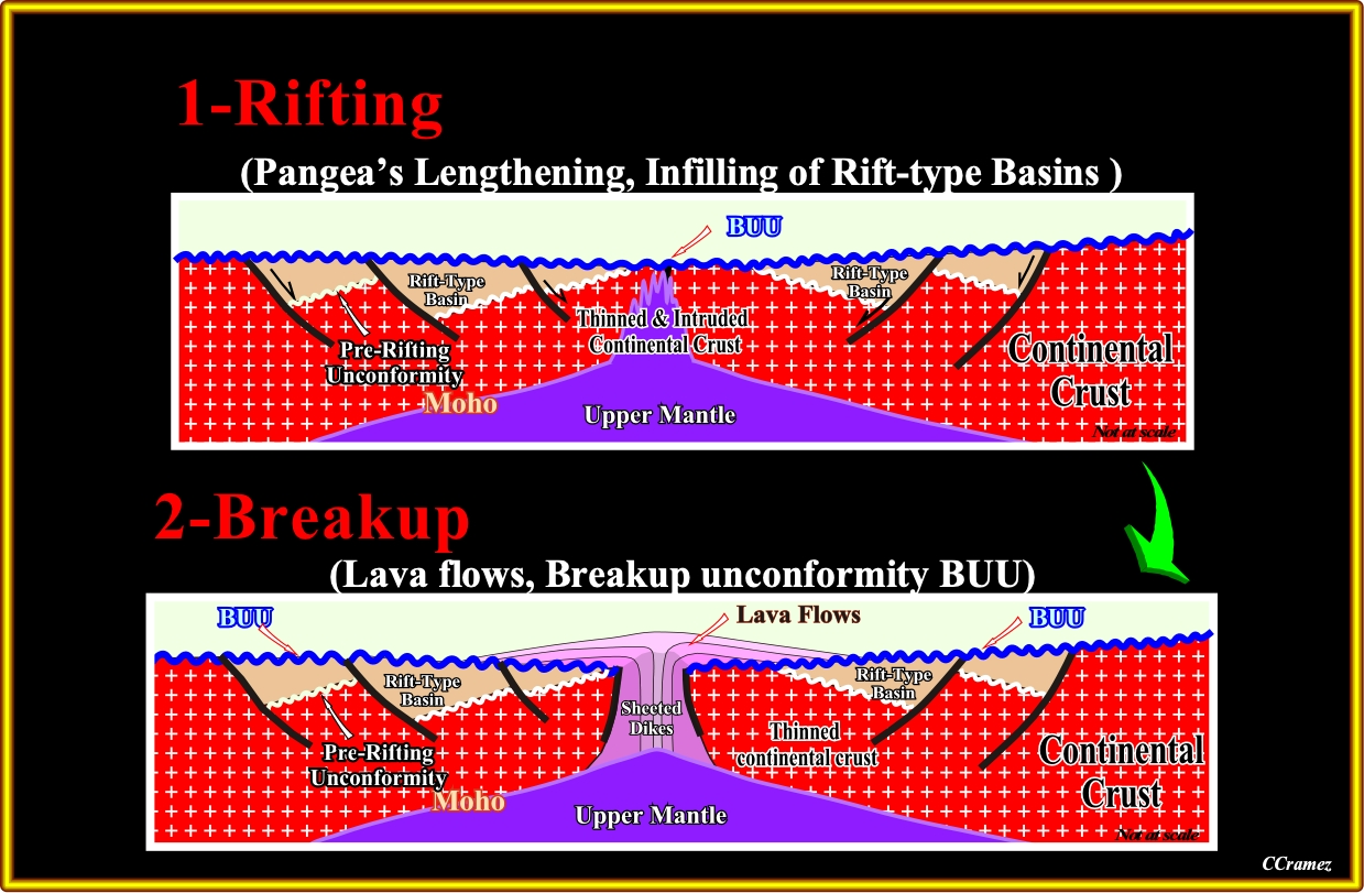
Pl005- During the rifting Phase (135-115 Ma), the lithospheric breakup of Pangea has been, closely, linked to underlying mantle plumes. Each plume of upwelling asthenosphere heated, elevated, magmatically under-plated and stretched a dome of overlying lithosphere. Stretching created asymmetric rift-type basins along the axis of the future ocean. As the lithosphere thinned by stretching and heating, igneous activity became increasingly common over time and nearer to the axis of rupture. After continental crust was stretched to a β factor of ≈2, abundant gabbroic melts were emplaced as dike swarms and sills in the extending crust. Eventually, before reaching a theoretical limit of β ≈4.5, rapidly stretched and magmatically injected continental crust broke up (Breakup volcanism at ± 135-130 Ma). As the continental crust dispersed, basaltic crust began to accrete and Neocomian flood basalts were extruded sub-aerially.
It is important to notice that the lengthening of the Pangea lithosphere ended with the breakup, which age change along the margin. All rift-type basins are bounded between the pre-rifting unconformity and the breakup unconformity. The lava-flows (sub-aerial lava froze under water) post-date the breakup unconformity. A parallel internal configuration of the rift-type basins (rate of extension higher than rate of deposition) favor deposition of organic rich lacustrine source-rocks (potential source-rocks). Since 2000, the large majority of geoscientists, particularly, those working in the hydrocarbon exploration of South Atlantic offshores, are aware that the predicted organic rich sediments (potential source-rocks) dipping seaward in Angola, Namibia, Brazil and Argentina offshores, became, after drilling, sterile sub-aerial lava-flows.
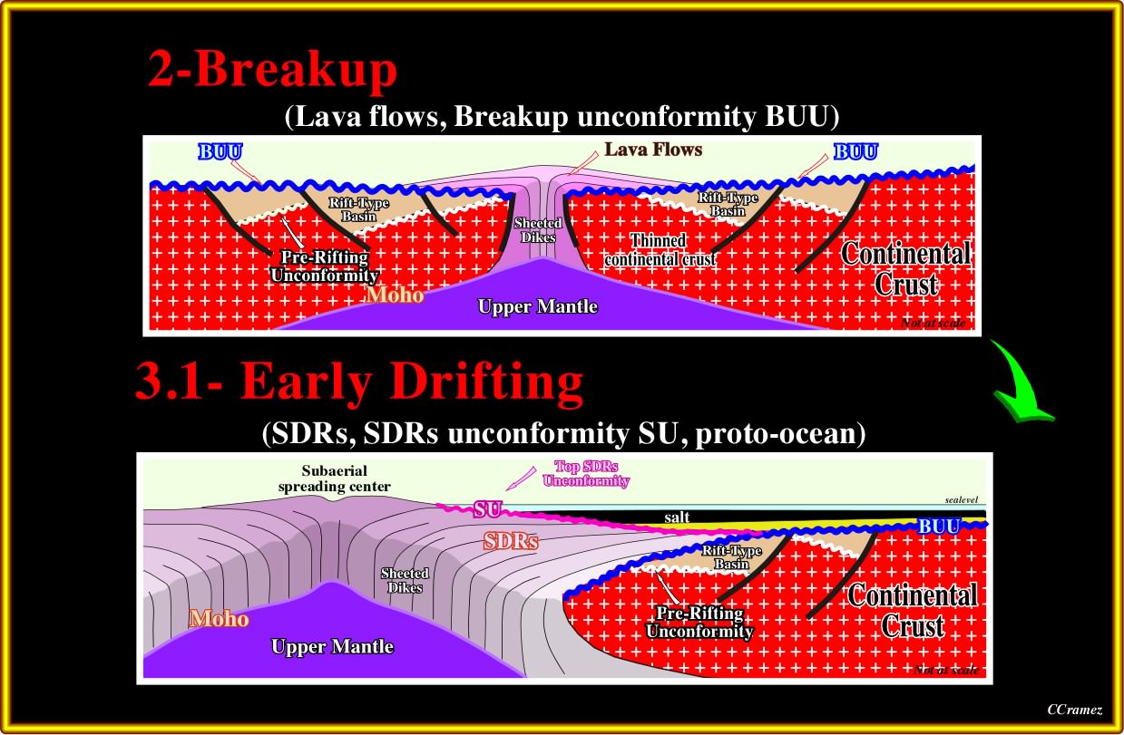
Plate 006- Lava flowed from sub-aerial spreading centers toward the continent across the distal rift-type basins. For the most part, sub-aerial spreading centers poured out extensive lava that flowed and thinned toward the continent. Vertical stacking of flows masks magnetic reversals including those in the underlying sheeted dikes, so this type of basaltic crust is, magnetically, quiet. As the underlying lithosphere cooled, thermal subsidence lowered the lava-flows below sea level. Environments became marine, and the spreading center submerged to become an oceanic ridge. Lava-flows no longer flooded, laterally, because they froze, rapidly, under the sea. The oceanic spreading center spread by injection of sheeted dikes. This geometry allows magnetic anomalies in submarine sheeted dikes to be more, easily, identified by potential field data than anomalies within or below the stacked sub-aerial flood basalts.
As the landward flowage of the volcanic material is discontinuous (in time and space), disconformities (not unconformities in the sequential stratigraphy sense) between set of lava-flows are possible, as well as, thin sedimentary intercalations, generally, without hydrocarbon potential.
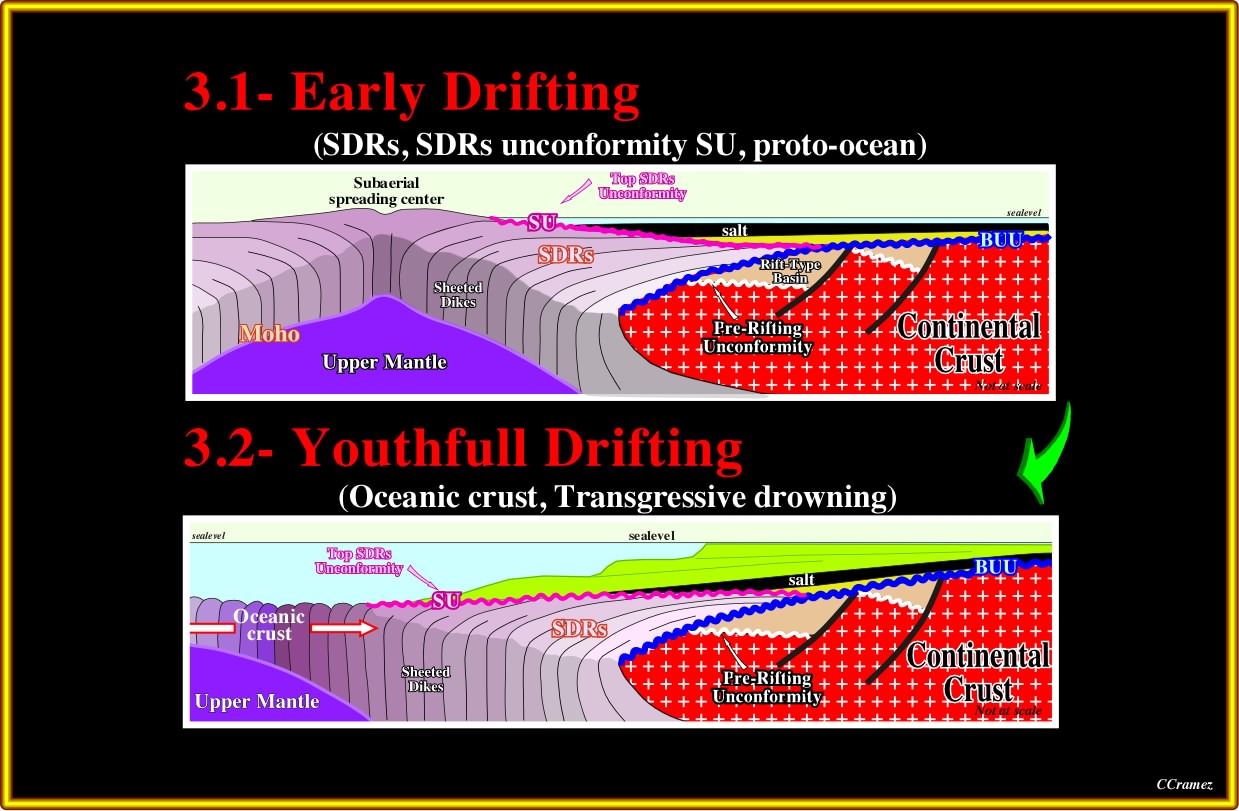
Plate 007- During the drifting transgressive phase (± 115-85 Ma), the Aptian evaporites or sandstones mark the onset of major transgression that continued until the end of the Cenomanian-Turonian. Transgression was driven, partly, by eustatic rise of sea level due to increased oceanic spreading rates, longer oceanic ridges and previous stretching of continents during the breakup of Pangea. Local lithospheric cooling of the continental margins, also, caused them to drown. During transgression, a landward-thickening wedge was built by carbonate and siliciclastic units, while marine facies encroached landward as backstepping marine platforms bounded by the coastal break and shelf break. The more or less continuous backstepping of the coastal deposits increased the water depth of the platform.
It is important to notice that contrariwise to the conventional view, in which the Aptian evaporites of South Atlantic predate the beginning of sea-floor spreading, here it is argued that the evaporites post-date the breakup of the Pangea lithosphere and initial seafloor spreading. In addition, in this hypothesis, the geochemistry and mineralogy of the evaporites is a circumstantial evidence for the association of the Aptian evaporites with the basaltic lav- flows (Hardi, 1983, 1990, 1996).
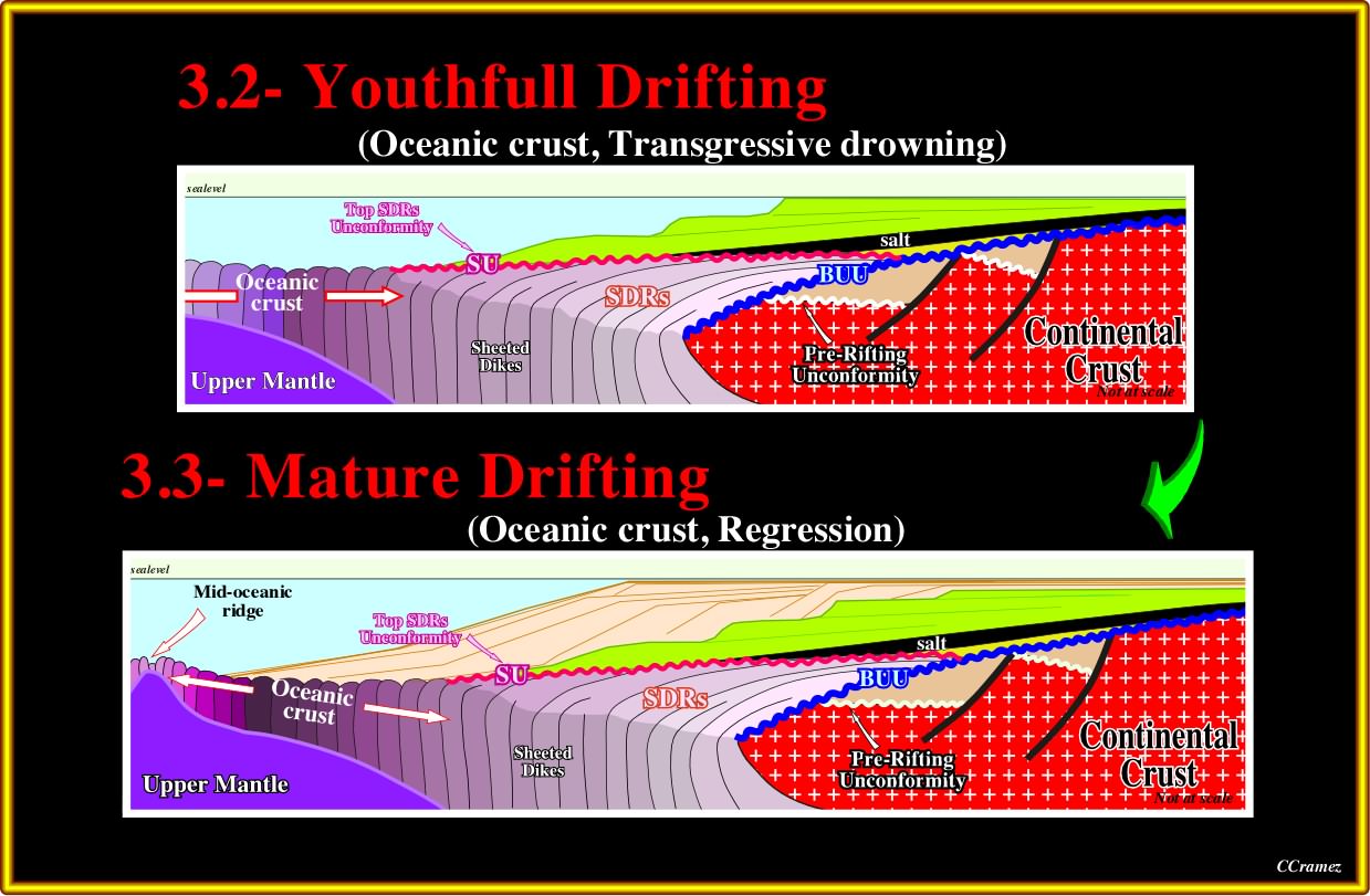
Plate 008- During the drifting regressive phase (± 60-0 Ma), the eustatic fall of sea level during the Tertiary was enhanced by epeirogenic uplift of continental crust. Each South Atlantic margin widened by progradation of a regressive wedge. On seismic lines, this regressive phase is separated from the underneath transgressive phase by a major downlap surface. Continental facies shifted seaward and the coastal break merged with the shelf break. The regressive wedge thickened seaward, then tapered into deep water. Epeirogenic local uplifts of several kilometers were created within the continents by intra-plate stress or by underlying igneous activity. The uplifts, locally, steepened the continental margins, and beveled major angular unconformities across them in the mid-Tertiary. The uplifts are, easy, recognized on the seismic lines, particularly, in onshore where they are more significant (2 - 3 kilometers). They explain why the organic matter of the potential source-rocks reached maturation, since, in several areas, the potential source-rocks, are presently, too shallow.
Be attentive to the difference between eustatic (absolute) and relative sea level. An eustatic or absolute sea level fall*, as the one occurred during the Tertiary, induces the regressive phase of the post-Pangea continental encroachment stratigraphic cycle. A relative fall of the sea level induces an unconformity, that is to say, an erosional surface. Put differently, a transgression is induced by a relative rise of the sea level (in acceleration), while a regression is induced by a relative rise of the sea level (in deceleration).
*Sea level referenced to a fixed point, which is, generally, the Earth's center. Using high-quality satellite radar near-global and homogeneous measurement of sea level is possible, thereby overcoming the inhomogeneous spatial sampling from coastal and island tide gauges. The absolute (eustatic) sea level rises or falls, mainly, function of the volume of the oceanic basins and volume of the ice sheets and ice caps (glaciers included). The water volume, under all its forms (solid, liquid and gaseous), is considered constant since the Earth's formation, around 4.5 Ga (109 years ago).
Summing up:
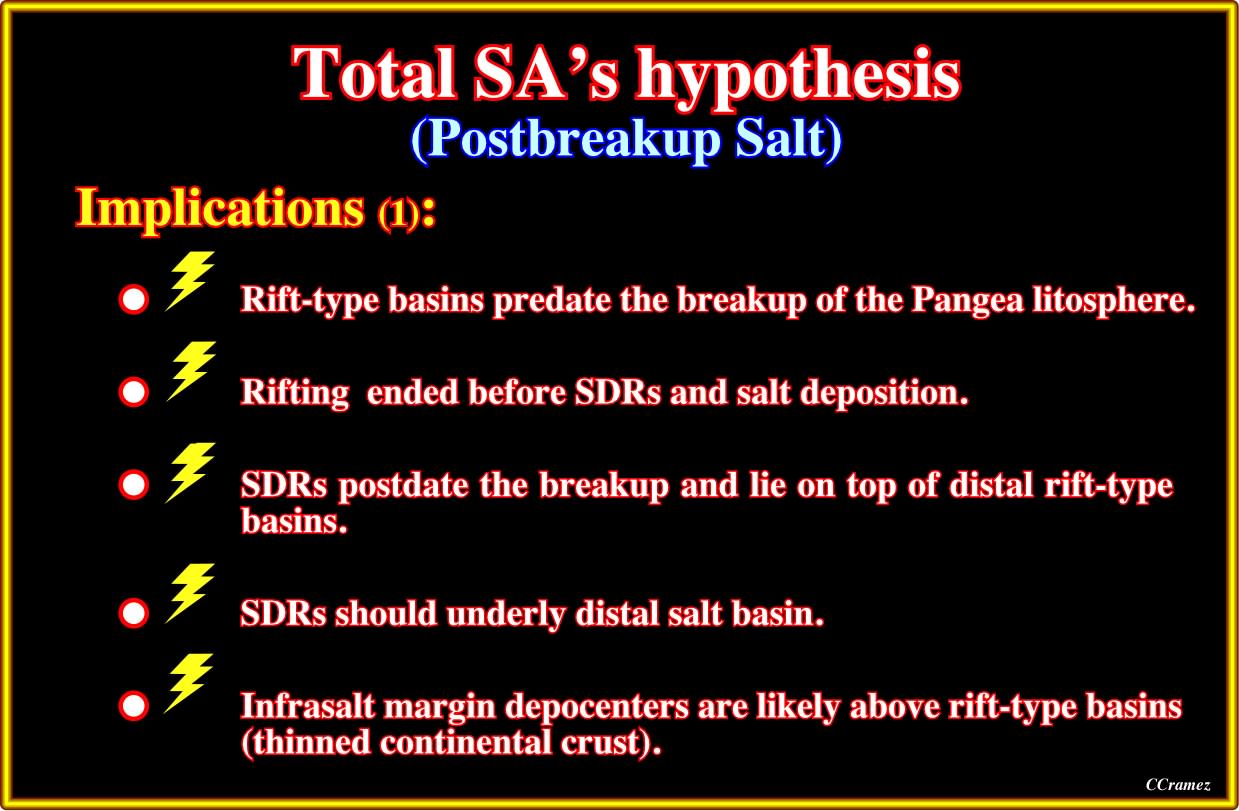
Plate 009- In relation to the conventional models, in Total SA's hypothesis not only the sub-aerial lava-flows (SDRs, i.e, seaward dipping reflectors) post-date the breakup of the Pangea lithosphere, but the evaporites as well. The rift-type basins, developed during the lengthening of the Pangea continental crust, are limited by the breakup unconformity and fossilized by either (i) the margin infra-salt sediments (evaporites or basal strata), (ii) the margin supra-salt sediments or (ii) the SDRs (just the more distal rift-type basins).
The alternative Total SA's hypothesis, in which salt basins formed after the continents separated follows Guiraud and Maurin, 1992 and Karner et al., 1999, i.e., postulated that the rifting ended before salt was deposited. The conjugate salt basins were always separate and independent. The Aptian salt, demonstrably, overlies the breakup unconformity (three dimensions plate-tectonic reconstructions are highly significant). At the oceanward edge of the salt basin, thin salt should pinch-out over oceanic or proto-oceanic crust. On the other hand,where the salt is undeformed, autochthonous salt is observed on seismic lines to pinch-out over oceanic crust in the Lower Congo Basin (Lehner and de Ruiter, 1977), South Gabon Basin (Meyers et al., 1996a), North Gabon and Douala basins (Meyers et al., 1996b). Elsewhere on the African margin (Lower Congo, Kwanza, and Benguela geographic basins), the autochthonous salt is, tectonically, thickened and is allochthonous along its leading edge, the Angolan Escarpment. These features obscure the original geometry of the salt. Wherever SDRs have been identified on both margins, they underlie the distal salt basin or its stratigraphic equivalent.
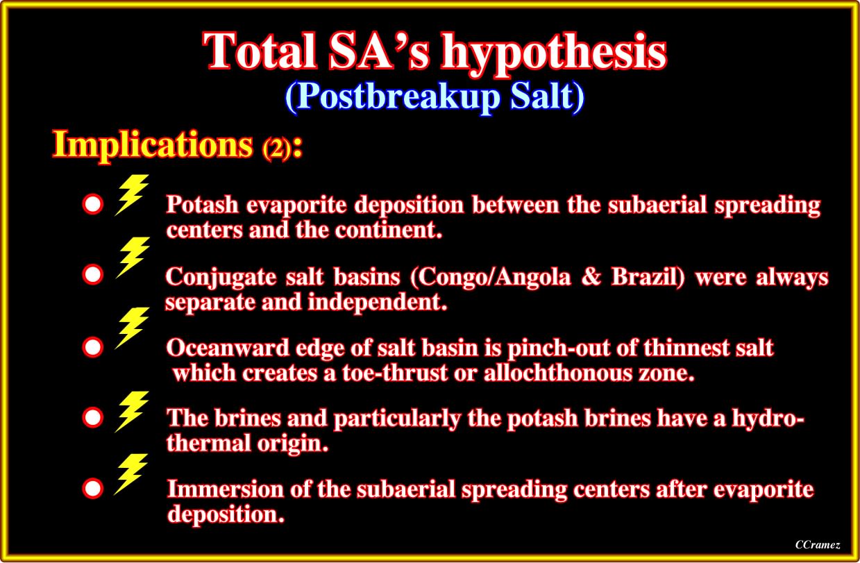
Plate 010- Potash evaporites are diagnostic of their brine source. They form two groups. A rarer group rich in MgSO2 forms by evaporation of seawater originating from rivers. The sulphate minerals, polyhalite, kainite, and kieserite, are diagnostic. The second, more common group is rich in KCl and CaCl2 and poor in MgSO4. This group cannot form by evaporation of seawater from rivers alone. The chloride minerals, sylvite, carnallite, tachyhydrite, and bischofite are diagnostic. CaCl2 brines that concentrate to form KCl minerals originate from brines enriched in CaCl2 by hydrothermal water-rock interaction. The most suitable host is basalt altered to spilitic greenstone. Albitization releases Ca into the brine, and chloritization absorbs Mg from the brine. As the brine wells up hydrothermally, the abundant Ca combines with any SO4 present to precipitate gypsum at the surface; the brine in lakes remains enriched in Ca. Other host rocks are also possible. Brine can interact with plagioclase-bearing arkoses or with Ca-smectites in red-beds ; limestones would also be a prolific source of Ca, but these are rare below the Aptian salts of the South Atlantic.
The presence of tachyhydrite and similar chlorides does not prove the bedrock near the evaporites was basalt. However, the thickness, high temperatures, and abundant plagioclase in flood basalts means that these will be the most prolific of Ca for CaCl2. All of the known Aptian potash evaporites in South Atlantic formed from CaCl2 brines enriched by hydrothermal alteration.
to continue press
next

Send E-mails to carloscramez@gmail.com or to carlos.cramez@bluewin.ch with comments and suggestions to improve these geological notes.
Copyright © 2012 Ccramez, Switzerland
Last updated: July, 2014