

Geological Problems of the Kwanza Geographic Basin
The geological map of the Kwanza geographic basin pose several problems that geoscientists must, tentatively, try to solve:
a) What is the salt substratum ?
b) What is the morphology of the bottom of the salt ?
c) Why depocenters seem to be displaced seaward ?
c.1) M. Jackson & M. Hudec's fore-deep hypothesis.
c.2) Critical test of fore-deep hypothesis (seismic lines SKB. 216 & SKB. 220).
d) How to explain the compressional uplift of the littoral area ?
e) How to explain the depositional volcanic high ?
f) How many salt depocenters there are in the basin ?
g) Where are the fracture zones & the depocenters ?
h) What role play the fracture zones ?a) What is the Salt Substratum ?
The drilling results allow to located, tentatively, the eastern limit of a volcanic deposition (figure 014). Such a boundary trends, roughly, NW-SE, passing through by Luanda city and southward, successively, by the exploration wells East of Zango ≠ 4, East of Bom Jesus ≠1 ; East of Galinda ≠1 ; East of Morro ≠4 ; East of Galinda ≠1 ; East of Cafegongamba ≠1 ; East of perfect Lady ≠1.
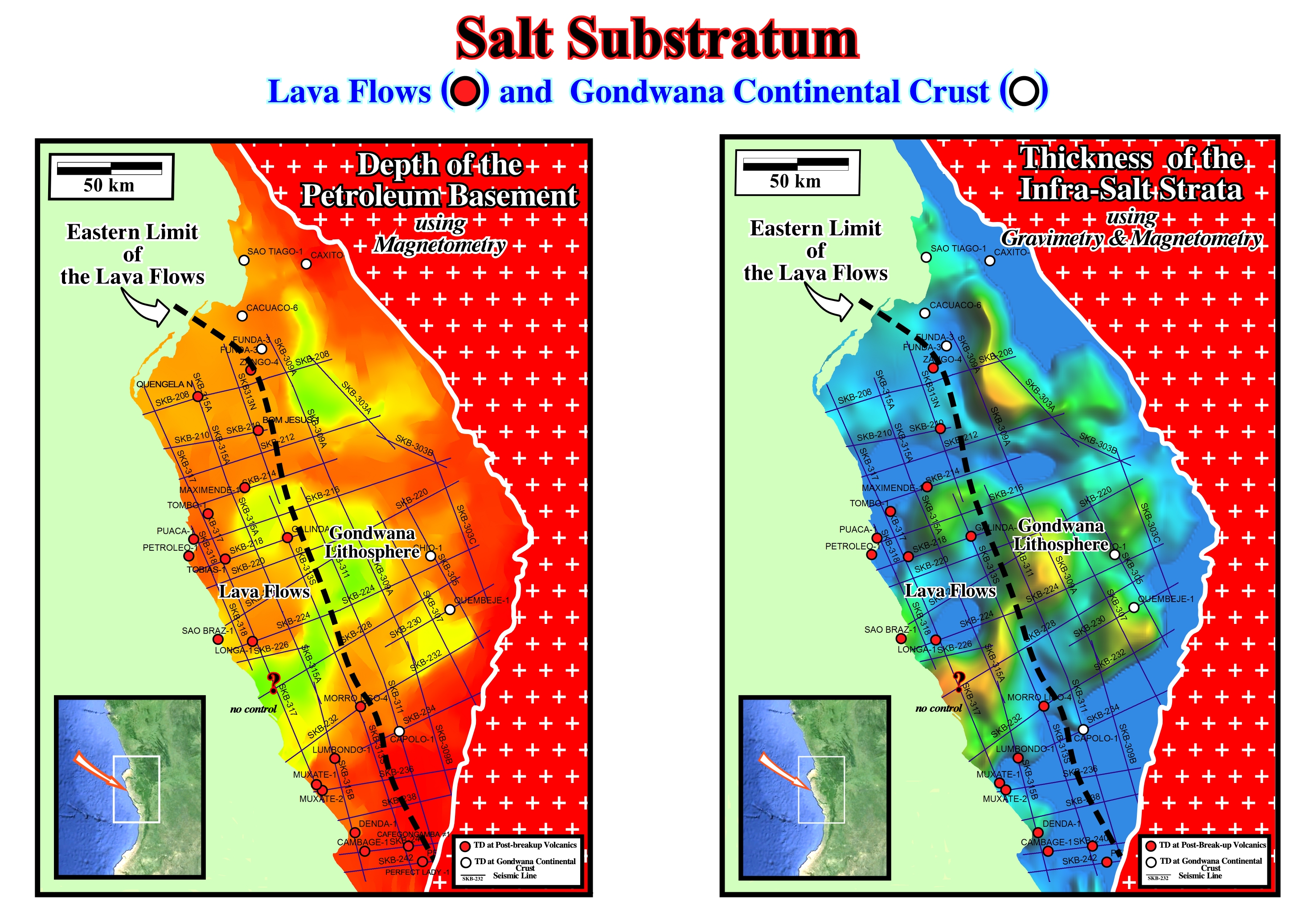
Figure 014- On the map illustrated on the left of this figure, the exploration wells reaching the Gondwana continental crust (granite-gneiss or Paleozoic metamorphic rocks) are all located in the proximal area of the basin (eastern part), where rift-type basins are, easily, recognized on the seismic lines (figure 019). On the contrary, in the western part, the exploration wells reached post break-up volcanic rocks, mainly, lava flows (sub-aerial deposition). In other words, just the distal rift-type basins. i.e., those located not far from the break-up zone can covered by the lava flows, which thick and dip seaward. The central and proximal rift-type basins are covered by the infra-salt margin sediments (fluvial/shallow-marine sandstones for the proximal rift-type basins and lacustrine shales for the central rift-type basins). The petroleum basement (figure 015) is quite high near the shoreline (particularly on the Cabo Ledo area), probably due to the emplacement of the lava flows, which postdate the break-up of the Gondwana lithosphere. On the map illustrated on the right of this figure (Thickness of the Infra-Salt Strata) one must differentiate the rift-type basin sediments from the infra-salt margin rocks (lavas flows and sediments). They are separated by a major geological event, i.e., by the break-up of the Gondwana lithosphere. Taking into account the depth of basement (left map) and the limit of the lava-flows (right map), it is logical to associate the western surface geological anomalies to the presence of lava flows in depth (lava flows do not outcrop). The southern part of these maps (southern Capolo-1) are not corroborated by the seismic lines, on which thick infra-salt sediments are discernible.
.Westward of such limit, all exploration wells, reaching the petroleum basement, were stopped in volcanic rocks (probably lava flows) after crossing the salt layer or the associated salt welds. On the contrary, eastward of such a limit, the wells reaching the petroleum basement were stopped on the Gondwana lithosphere (sialic rocks).
b) What is the Morphology of the Bottom of the Salt ?
Taking into account, the Late Tertiary uplift of the Eastern Africa margin and, particularly, of the onshore of the Kwanza geographic basin, the isobaths the basement and bottom of the salt (Figure 015), built-up with the results of the exploration wells, do not falsify the conjectural presence, in the western part of this onshore, of a thinning eastward depositional volcanic complex.
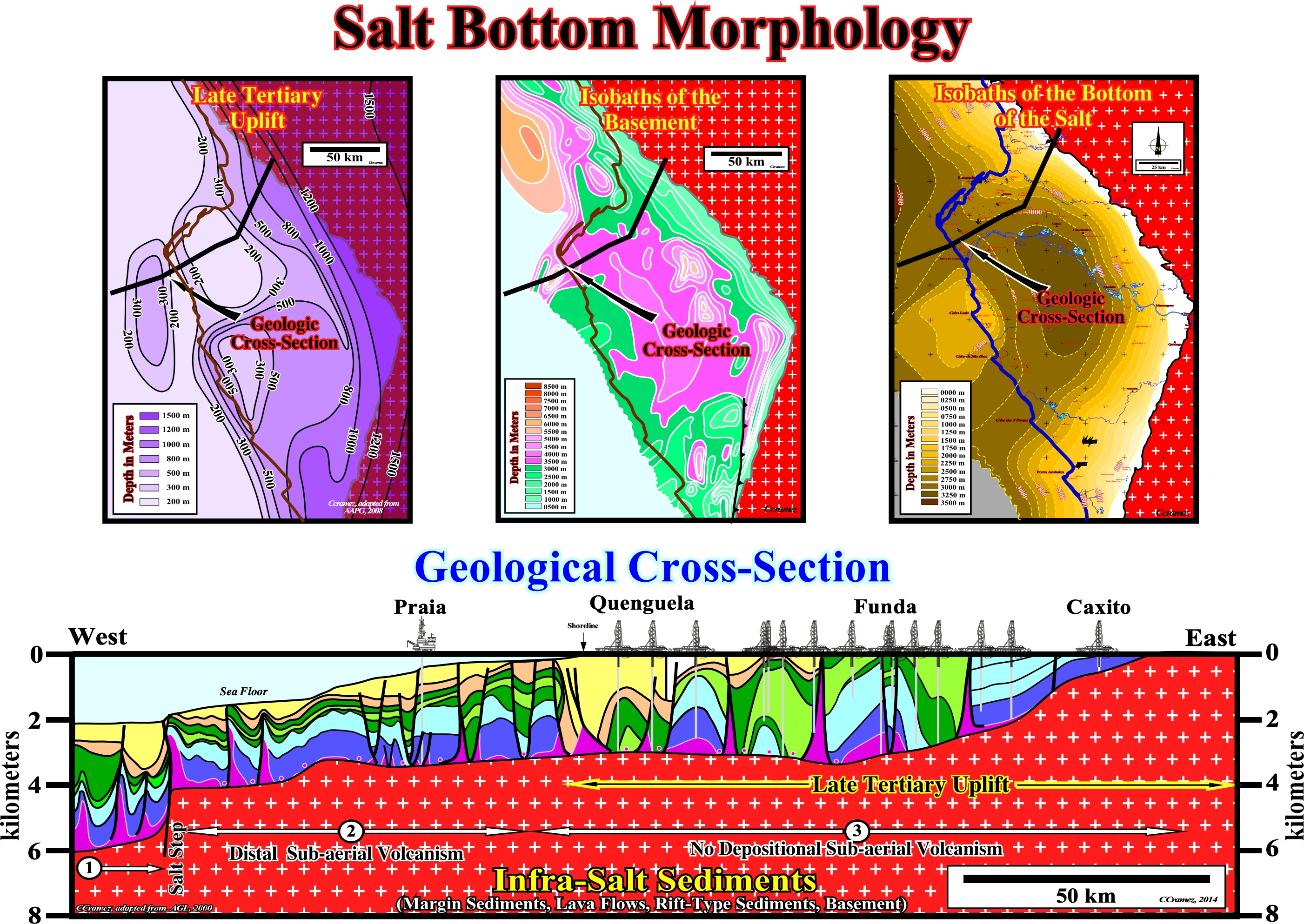
Figure 015- There are four main evidences of the Late-Tertiary uplift of the SW Africa : (i) Topography of SW Africa ; (ii) Erosional truncation on seismic lines ; (iii) Reactivation of salt steps and fracture zones ; (iv) Kübler index & vitrinite reflectance. The Late-Tertiary uplift is, extremely, important for the petroleum exploration. It controls, partially, several petroleum parameters. In fact, such uplift induces: (a) The motion gravity-driven deformations with the creation of potential structural and non-structural traps ; (b) The supply of clastic sediments (potential reservoir-rocks) during the associated depositional lowstand geological conditions (relative sea level lower than the basin edge), mainly, outward of the river's mouths (as Congo and Kwanza rivers) ; (c) Salt tectonics and halokinesis (formation of potential petroleum traps) by sediments dumping and (d) The elevation of source-rocks (mature organic matter). The isobath map of the basement shows a big through in the Kwanza onshore. In the offshore northward of Luanda city (westward of Barra do Dande), there is a small trough of the basement, individualized from the big Kwanza onshore trough by a major fracture zone. Northward of this area, the bottom of the basement dips, progressively, seaward without any basement anomaly. Concerning the map of the bottom of the salt (map of the salt induced tectonic disharmony), just the big Kwanza onshore trough is discernible. Northward of the major SW-NE fracture zone passing near Luanda, the bottom of the salt dips, regularly, seaward: any proximal sedimentary depocenter is observable as it is the case in Kwanza onshore eastward of the depositional volcanic high (Cabo Ledo area). As depicted on the above regional geological cross-section of the Kwanza geographic basin (see location on isobath maps), several infra-salt topographic steps (ramps) are recognized. These steps were, probably, reactivated during the Late Tertiary uplift, inducing a significant erosional unroofing, which created an enormous increasing of the terrigeneous supply, particularly, outward of the mouth of major streams. These infra-salt steps, which seem to associated with major fracture zones of the basement, were fossilized by the evaporite strata defining three major salt provinces , as will see later.
As illustrated in figure 015 (Late Tertiary Uplift), according several geoscientists (AGL), the Kwanza rim and Precambrian hinterland were exhumed between 1 and 4,000 meters, but the tilting did not affect, appreciably, the northern coastal plain of Kwanza basin. The largest uplift was in the Precambrian hinterland (around 2 - 4 km). In Cabo Ledo area, the uplift was around 100 - 1,500 meters. A small Neogene uplift (150 - 200 m) tilted seaward the shelf and upper slope. Between Quenguela and Funda depocenters (between Hotspur and Quenguela fractures zones), there was exhumation, as well as, in Chio, Quembeje, Muxima area and, locally. in Cabo Ledo area.
c) Why the Depocenters Seem Displaced Eastward ?
For some geoscientists, the geological map of the Kwanza geographic basin raised two important problems in the understanding the geodynamics, particularly, of the onshore :
1) Why the depocenters seem are displaced Eastward ?
2) Why the central part of the onshore continued to deepen in relation to the coastal zone ?To date, no geoscientist proposed a clear mechanism to explain this problem, either by thermal mechanism (lack of heat flow ± 30 My after rifting) or by an extensive mechanism (no rifting after the break-up of the lithosphere). In my opinion all these problems can, easily, be explained by the emplacement of the lava flows. In fact, the deposition lava flows, immediately, after the break-up of the lithosphere, form an important retrogradational stacking of lava deltas if they enter into a conjectural water-body (lake or epicontinental sea), while the continental crust (basement plus rift-type basins and infra-salt margins sediments), not covered by the lava flows, continue to subside (see later).
M. Jackson and M. Hudec (AGL., 2000) propose a conjectural solution assuming the inner Kwanza geographic basin corresponf to a foredeep basin caused by loading the Precambrian crust thrusts (Congo craton) in the eastern edge basin (see next).
c.1) M. Jackson & M. Hudec's Fore-deep Hypothesis
M. Jackson and M. Hudec tried to confirm (verificationism) and not refute (criticism) their conjectural solution. They choose on the geological map, the Carimba area (black rectangle on the geological map of figure below) and they proposed a new cartography, in compression, with anticlines and reverse faults as illustrated in the figure 016.
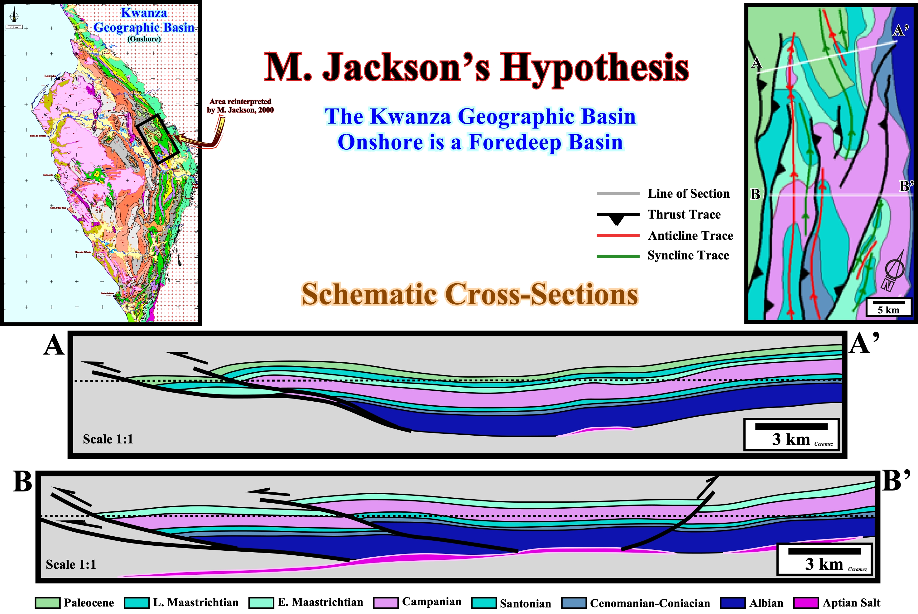
Figure 016- On the geological map (left upper corner), the area inside the black rectangle, was the area chosen by M. Jackson and M. Hudec to tentatively test the conjecture they advanced, i.e., the onshore of the Kwanza geographic basin corresponds to a foredeep basin induced by the Congo craton. In reality, they did not test (criticize) their conjecture. They just try to validated it. They reinterpret in compression (shortening) the original mapping of the Carimba region (map in the upper right corner) and then, they proposed two geological cross-sections (AA' and B-B'). However, they never had the opportunity to go to the field to test their conjecture and they have no access to the seismic lines shot by Total CAP (1969-1970) and, obviously, to the new seismic lines shot by Sonangol in 2012.
Using their mapping in compression, they did two geological cross-sections (Figure 016), which show, evidently, anticlines and reverse faults. Then, they use such structures to proof their compressional cartography, which, according to them, confirms that the onshore of the Kwanza geographic basin can be considered as a foredeep basin. Such approach is far from the scientific method. It corresponds to a magnificent vicious circle (an hypothesis is advancing, it requires a certain mapping, the mapping is made, which is then used in the built geological cross-sections to validate the hypothesis advanced).
c.2) Critical Test of Fore-deep Hypothesis (using seismic sines SKB. 216 & SKB. 220)
The conjecture of M. Jackson and M. Hudec implies the presence of folds and thrusts, at least, in the proximal part of the basin, whose presence or absence can be regarded as a refutation test:
- If a geoscientist finds shortening structures (anticlines, reverse faults or thrusts), in the eastern part of the basin, the hypothesis of a foredeep is corroborated, but not verified. In Science and, particularly, in Geology, there are no true hypotheses. An hypothesis can be refute or corroborate, but never verified (true hypotheses do not exist in Science): a corroborated hypothesis can always be refuted with new data.
- If a geoscientist, on the contrary, doesn't find, on the ground or on seismic data (old or new seismic lines), shortening structures (compressive structures), the foredeep hypothesis is, simply, rejected.
The Canvas auto-traces (figure 017) of two details of the SKB-216 and SKB-220 seismic lines are, highly, interesting for testing the advanced foredeep hypothesis.
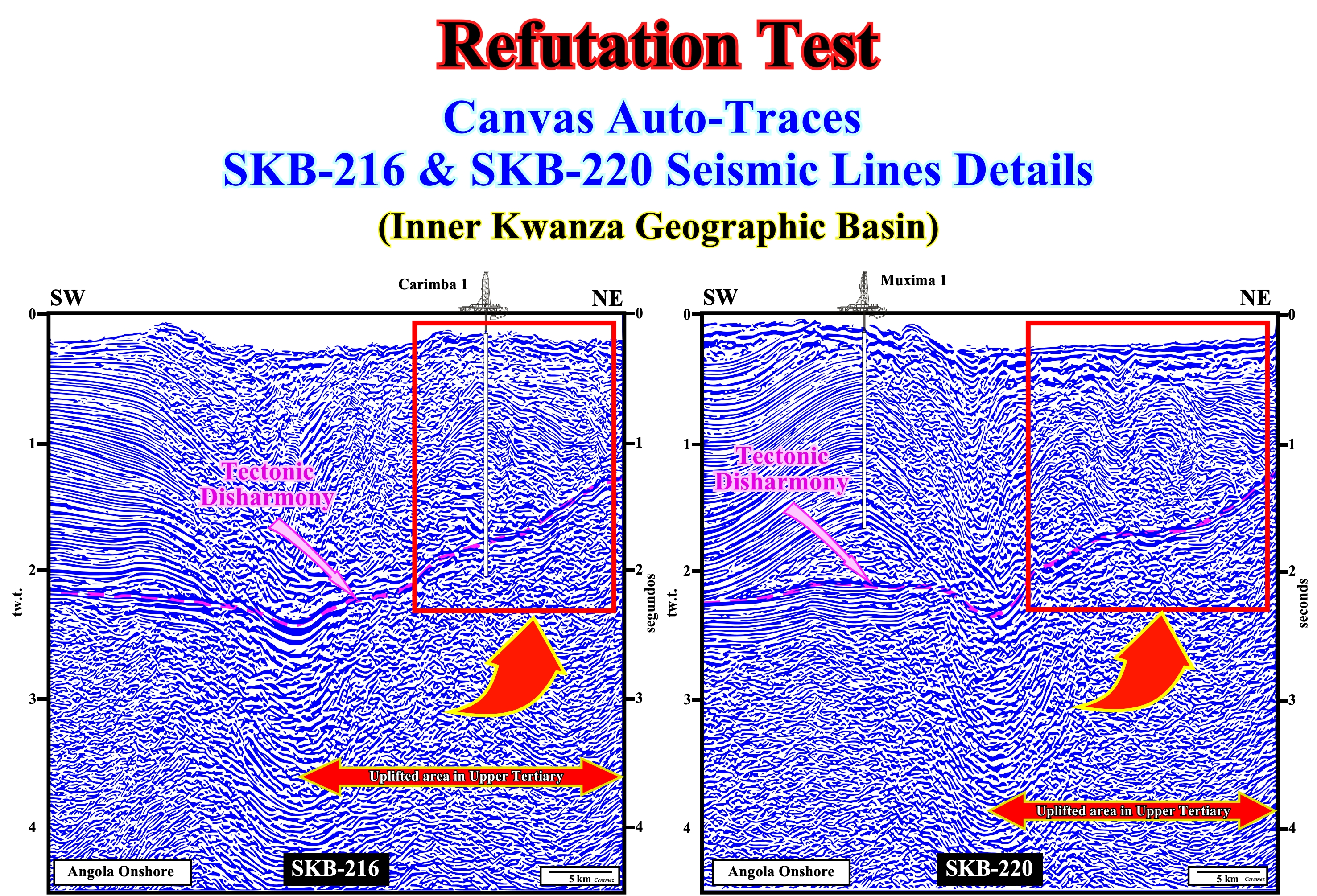
Figure 017- As it can be seen in these auto-traces (software CanvasDraw 6) of the details of the SKB 216 & SKB 220 seismic lines, any shortened structure (compressional) is evident in Carimba area (area remapping by M. Jackson and M.Hudec). Any anticline or reverse fault can be highlighted. Above the tectonic disharmony (base of salt for many geoscientists working in Angola), all structures are extensional (antiforms, synforms and normal faults). They are induced by the movements of salt interval (mainly by halokinesis). The Late Tertiary uplift of the tectonic disharmony, which is obvious on these auto-traces, is not to favorable either with a fore-deep interpretation. This uplift is not associated with a tectonic compressional regime (σ1 horizontal), but to extensional tectonic regime (σ1 vertical). Extensional uplifts, as those induced by basement block tectonics, isostatic balance or salt diapirism, do not shorten the sediments, but, on the contrary, they lengthened them by normal faulting.
The Canvas auto-traces of new seismic lines shot by Sonangol (SKB campaign, 2012) falsified, completely, the foredeep hypothesis. Any sedimentary shortening structure is visible on seismic lines shot in the Carimba area (figure 017). The sediments were lengthened, by halokinesis and not shortened as assumed on the schematic cross-section proposed by M. Jackson and M. Hudec. In addition, the geometry of the bottom of the salt interval, which was deformed by the Late Tertiary uplift (tilted westward), is incompatible with the supposed loading of the thrusts of the West Congo folded belt (Late Precambrian/ Middle Cambrian), which should create a flexural subsidence.