

Lithostratigraphy & Seismostratigraphy
In the figure below is represented a tentative "lithostratigraphy" of the onshore Kwanza Geographic Basin and a tentative "seismostratigraphy", i.e, stratigraphy using seismic data seismic data based on the conjecture that primary seismic reflectors represent major major chronostratigraphic interfaces. The lithostratigraphy corresponds the vertical succession of geological formations, in which various facies (lithology and fauna characteristic) can be put in evidence, which means that it is not a true lithostratigraphy. The tentative "seismostratigraphy" is the stacking of seismic intervals that can be followed and mapped on the seismic lines (old and new seismic lines).
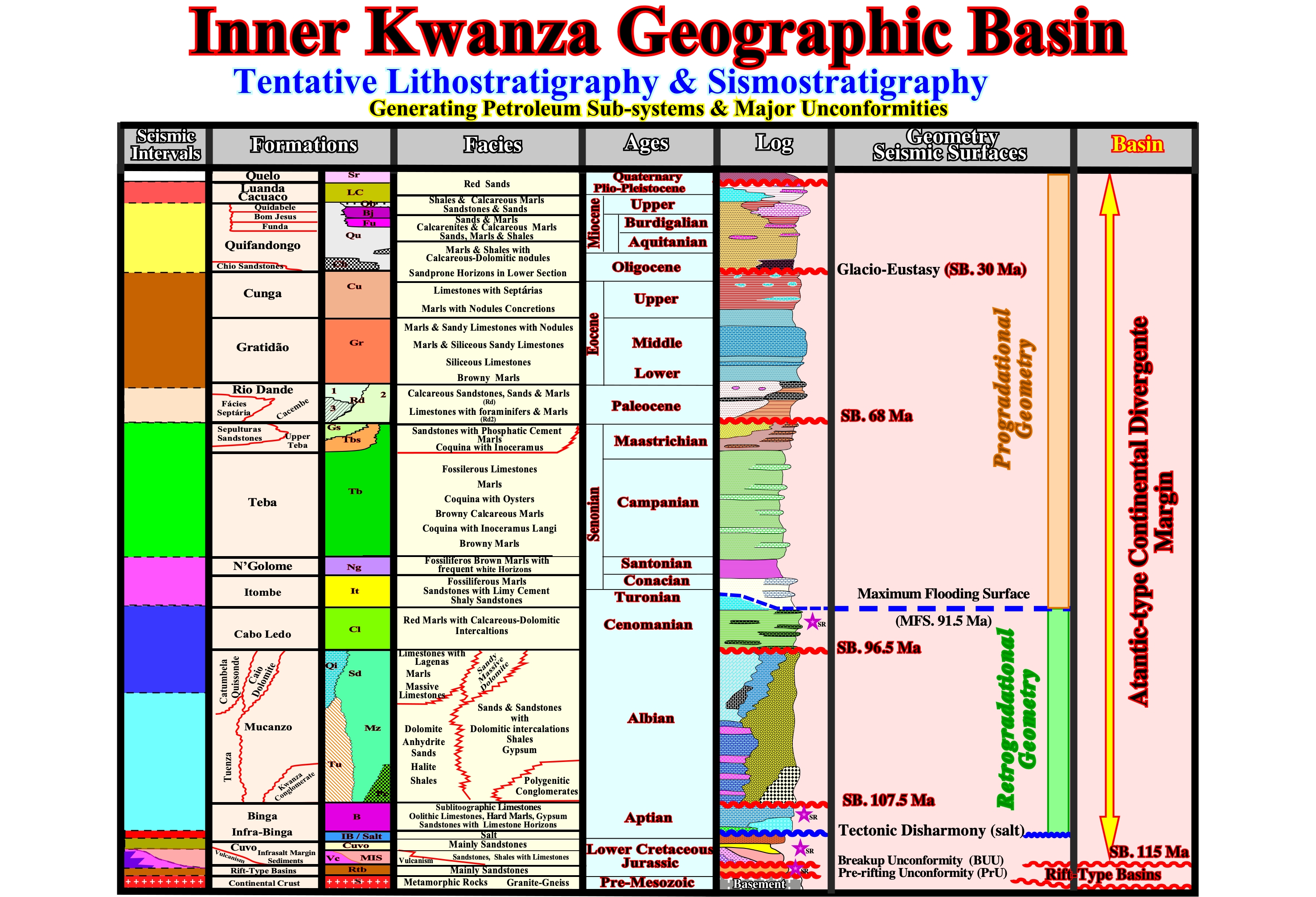
Figure 028- In this figure is illustrated a tentative stratigraphy based in geological formations more than in the lithology, that, by commodity, we call "lithostratigraphy". The majority of the geologic formations of this geographic basin have several facies (lithology plus a typical fauna). This is, particularly, true in the Mucanzo formation, in which different facies are recognized : (i) Kwanza facies (polygenic conglomerates) ; (ii) Caio facies (sandy dolomite) ; (iii) Catumbela / Quissonde facies (limestones, marls) ; (iv) Mucanzo facies "lato sensum" (sand, sandstones, gypsum, dolomite). The tentative seismostratigraphy corresponds to the stacking of the seismic intervals that can be picked and mapped on the seismic lines, i.e., the seismic intervals that, at least, in one part of the basin (generally near the continental break) are underlined by reflectors associated with unconformities (erosional surface) and that can be followed down-dip (by correlation), where they are less evident. The major unconformities, the Cenomanian/Turonian (MFS. 91.5 Ma) downlap surface and the stratigraphic phases of the post-Pangea continental stratigraphic encroachment cycle, (rift-type basins plus divergent margin) are, also illustrated.
a) Unconformities & Sedimentary Basins
On the proposed field stratigraphic column (figure 028) several unconformities (erosional surfaces induced by significant relative sea level falls) are considered. From the older to the younger, the following unconformities were recognized :
i) Pre-rifting Unconformity (PRU) ;
This unconformity corresponds to the onset of the lengthening of the Gondwana lithosphere, i.e., to the formation of the rift-type basins. In this area of the South Atlantic, the age of the pre-rifting unconformity is ± 135 Ma.
ii) Break-up Unconformity (BUU) ;
This unconformity underlines the more important geologic event since the Pangea formation. It marks the break-up of the Gondwana lithosphere (southern Pangea continent) that causes the individualization of the South America and Africa tectonic plates. In this part of the South Atlantic, the age of this unconformity is ± 115 Ma (the break-up was done from South to North).
iii) Top lava flows (sub-aerial) ;
Top of the lava flows deposited, immediately, after the break-up unconformity. It underlies the submersion of the expansion centers, i.e., with the beginning of the oceanic crust formation (pillow-lava), since the volcanic material cannot flow under water. The age of this unconformity is estimated at ± 110 Ma.
iv) Top Albian Unconformity ;
This unconformity underlines a significant relative sea level fall that took place, ± 107 Ma (millions years ago). It corresponds, roughly, to the limit between the Aptian and Albian, which according Gradstein et al. (1994) took place 112 Ma.
v) Cenomanian Unconformity ;
This unconformity marks, more or less, the boundary between the Albian and Cenomanian. According Gradstein et al. (1994) took place, approximately, at 98.9 Ma. In the Mesozoic eustatic curve, the age of the relative sea level fall, which induced this unconformity, is 96.5 Ma (Gradstein et al. 1994).
vi) Top Cretaceous Unconformity (SB. 68 Ma) ;
In the chronostratigraphic chart, the limit between the Cretaceous (Maastrichtian) and Tertiary (Danian) is, more or less, 65 Ma. In terms of sequential stratigraphy, the associated the relative sea level fall seems to be, slightly older, ± 68 Ma.
vii) Oligocene Unconformity (SB. 30 Ma).
This unconformity corresponds, roughly, to the limit between the Rupelian and Chattian (± 26,50 Ma). It is, easily, recognized in all South Atlantic margins. Probably, it was induced by the absolute (eustatic) sea level fall created by the formation of the Antarctic glacial cap.
Two types of sedimentary basins (Bally and Snelson's basins classification) are recognized in this stratigraphy column, as well as on the seismic lines (figure 029):
- Late Jurassic / Early Cretaceous rift-type basins ;
- A Mesozoic -Cenozoic Atlantic-type divergent margin.The rift-type basins, which correspond to half-grabens, are limited between the pre-rifting (± 135 Ma) and break-up (±115 Ma) unconformities. The Mesozoic -Cenozoic Atlantic-type divergent margin is limited, at the base, by the break-up unconformity and goes till today.
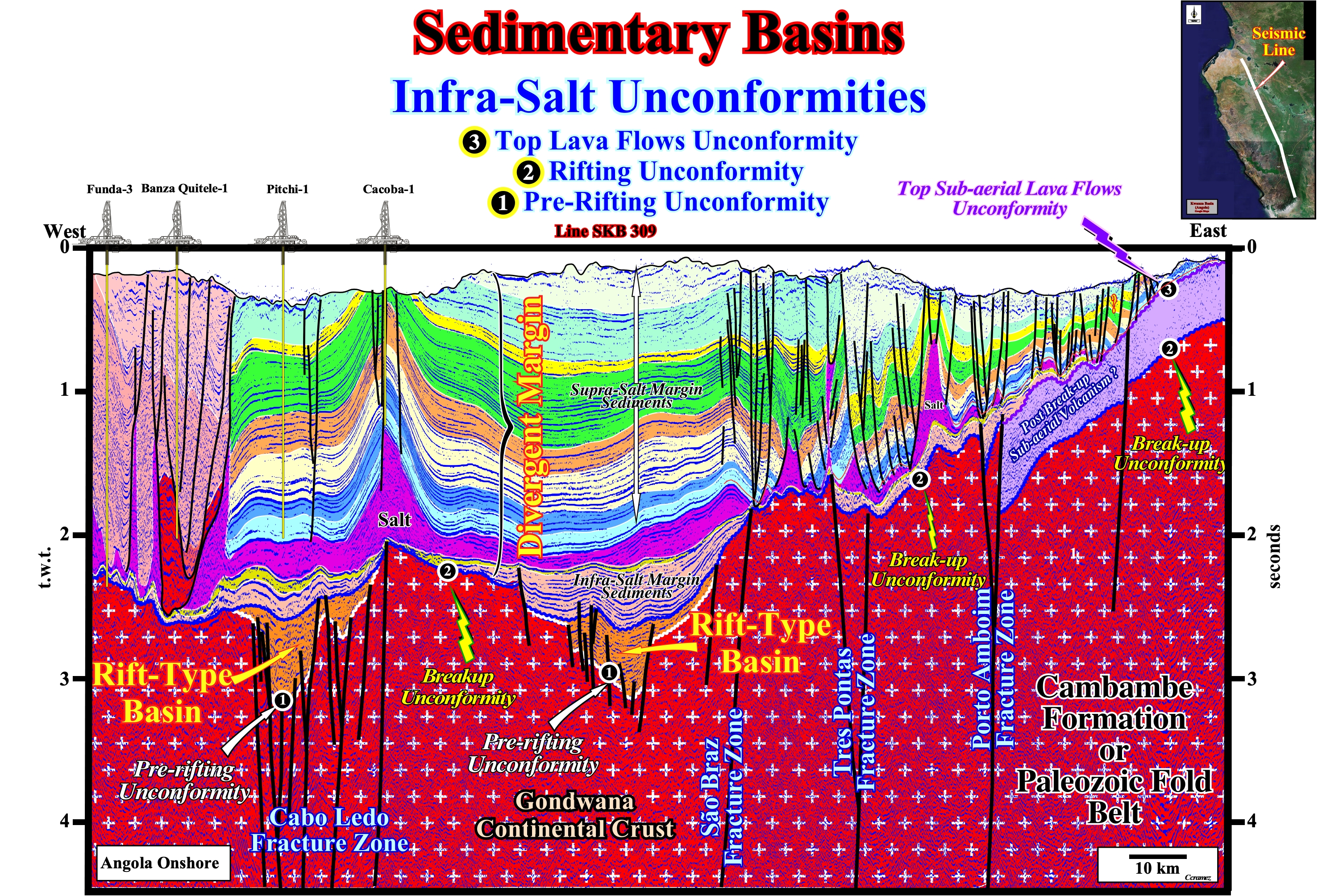
Figure 029 - On this tentative interpretation of a Canvas auto-trace of a seismic line (strike line) of the onshore Kwanza geographic basin, two types of sedimentary basins are easily recognized: (i) Rift-type basin and (ii) Atlantic-type divergent margin. The rift-type basins are bounded by the pre-rifting unconformity (1) and break-up unconformity (2). In association with the break-up unconformity, a sub-aerial complex of lava flows was deposited near the break-up zone, which top (unconformity (3) acts, locally, as a substratum of the margin sediments. The divergent margin is limited between the break-up unconformity (2) or the top of the sub-aerial flows unconformity (3) and the surface. It is important to notice that on this tentative geological interpretation, the considered supra-salt sedimentary packages are not calibrated either in terms of field geological formations or geological time.
As illustrated above, the rift-type basin sediments fill half-graben structures developed by a differential subsidence. If the size of the rift-type basins is large enough and the rate of extension not balanced by rate of terrigeneous influx (parallel internal configuration), the development of potential lacustrine source-rocks is possible. The divergent margin sediments fill a quite large and complex depocenter created, mainly, by the combined action of a thermal subsidence, sea level changes (absolute and relative) and sea floor spreading.
The deposit of significant salt interval in the divergent margin induced a very clear tectonic disharmony at the bottom of the salt (or associated salt welds). The salt induced tectonic disharmony allows geoscientists to sub-divide the margin sediments into: a) Infra-salt margin sediments, b) Massif and layered salt interval or associated salt welds and c) Supra-salt sediments (overburden). The thickness of the infra-salt margin sediments changes a lot due to local development of depocenters in which potential non-marine (lacustrine) source-rocks can be deposited. Some of these depocenters grow above rift-type basins (see figure 029), reminding the "steer's head" basin of Mckenzie rifting model. Potential marine source rocks can develop in the supra-salt sediments in association with the marine ingressions as discussed in next section.
b) Transgressive & Regressive Phases
Theoretically, after the filling of the rift-type basins, created during the lengthening of the Pangea lithosphere, a divergent continental margin is deposited in association with the 1st order continental eustatic cycle. The absolute sea level rises*, during the dispersion of the continents resulting from the rupture of the Pangea, reaches an eustatic high and then, falls as the continents, progressively, aggregate each other. In association with the marine ingression is deposited a backstepping sedimentary transgressive phase. The sedimentary unities composing these phase become condensed seaward. In association with the marine regression a forestepping sedimentary regressive phase is deposited. The sediments of the transgressive phase have a retrogradational geometry while those of the regressive phase have a progradational geometry. The sediments related with the downlap surface separating the transgressive and regressive phases are, generally, organic rich. They can be very good marine source-rocks if burred enough to their organic matter reach maturation. Knowing this, it is very easy to locate the potential marine source rocks on seismic lines, as illustrated on figure 030.
* Sea level referenced to a fixed point, which is, generally, the Earth's center. The absolute (eustatic) sea level rises or falls, mainly, function of the volume of the oceanic basins and volume of the ice sheets and ice caps (glaciers included). The water volume, under all its forms (solid, liquid and gaseous), is considered constant since the Earth's formation, around 4.5 Ga (109 years ago). The absolute or eustatic sea level should not be confused with the relative sea level, which is the sea level referenced to any point on the land surface either the top of the continental crust (base of the sediments) or the sea floor and which is the result of the combined action of the absolute or eustatic sea level and tectonics (subsidence or uplift of the sea floor).
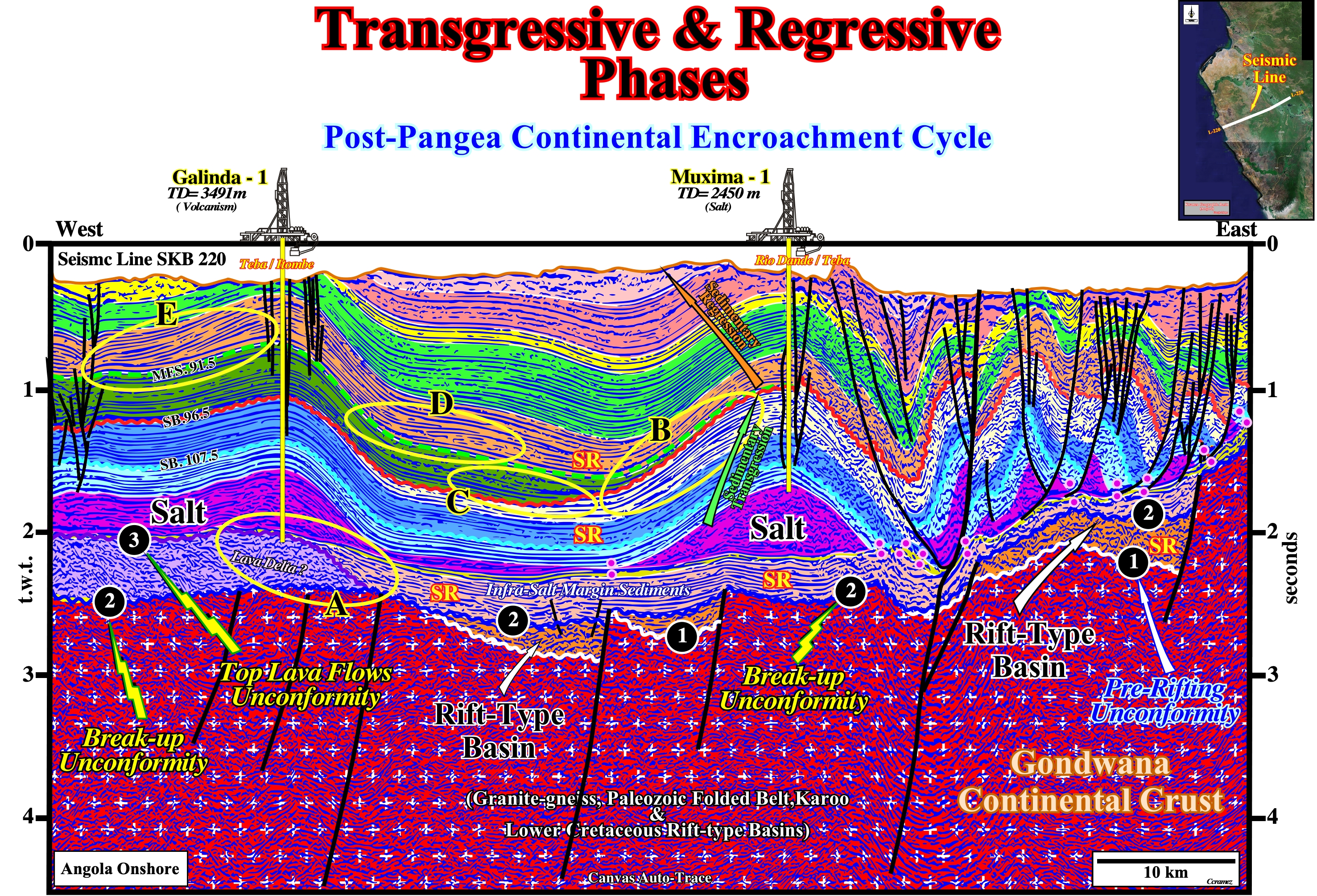
Figure 030- Before trying to locate the more likely marine source-rocks on this tentative geological interpretation of a Canvas auto-trace of an Angola offshore seismic line (Inner Kwanza Geographic Basin), it is important to recognize the main unconformities: (1) Pre-rifting unconformity ; (2) Break-up unconformity and (3) Top lava flows unconformity. The rift-type basins are bounded between the (1) pre-rifting unconformity and (2) the break-up unconformity. The divergent margin is bounded between the break-up unconformity (2) and the surface. The infra-salt margin interval is delimited between the bottom of the salt (or associated salt weld) and the unconformity (2) . This interval is composed by siliclastic and volcanic rocks with, locally, carbonates. An unconformity (top lava flows unconformity (3) separates the volcanic and siliclastic rocks, as illustrated on the area A (yellow ellipse). Knowing the geometry of the continental encroachment cycle (see text), the downlap surface (green dashed line, MFS 91.5 Ma) along which potential marine source-rocks can be found, it is easily recognized. Above it, a progradational geometry is recognized (areas E, D, and B). Under the downlap surface, intervals with parallel or retrogradational internal configuration are visible quite often (areas C and B). The Aptian evaporites or the sandstones, immediately below the salt, underline the onset of the Cretaceous sedimentary transgression, which ended in Cenomanian/Turonian. This sedimentary transgression was created by the absolute sea level rise induced by : (i) Increasing of the rate of oceanic expansion ; (ii) Volume of oceanic ridges ; (iii) Lengthening of the lithosphere before the Pangea break-up.
Potential source-rocks are associated with condensed stratigraphic sections, rich in organic matter, which deposited, immediately after, the peak of marine ingression (see figure 030). In infra-salt sediments, rocks with source-rocks characteristics were, often, deposited (see later). The post-Pangea eustatic acme was reached during maximum dispersion of the continents, which reduced, considerably, the volume of oceanic basins. It separates the transgressive retrogradational phase (drifting of the continents) of the progradational regressive phase (agglutination of the continents) of continental encroachment cycle.
Since the continents, created by the rupture of the Pangea, reached the maximum of dispersion, they began to regroup due to the subduction of the oceanic crust and continental collisions. The volume of ocean basins decreased and the absolute sea level began to fall starting the stratigraphic regressive phase of the continental encroachment cycle. With important seaward and downward displacements of the coastal onlaps and subsequent relative sea level rise starts the depositing of the continental encroachment of sub-cycles which fossilized, progressively, by downlapping the transgressive phase and lava flows deposited, immediately, after the break-up of the lithosphere. At this stage, potential source-rocks, as well as, reservoir-rocks are, often, associated with deep-water sediments.
c) Infra-Salt Seismostratigraphy
The Gondwana continental crust of is formed by granitic rocks or Paleozoic rocks, generally, without any generating petroleum sub-system (without source-rocks). The rift-type basins, which predate the break-up of the Gondwana lithosphere, are mainly half-grabens (with a continentward vergence) filled by non-marine sediments or lacustrine rocks (figure 031). When the internal configuration of filling of the rift-type basin is divergent toward the bordering fault, the likelihood of source-rocks is very small. The source-rocks are more likely when the internal configuration of the infilling sediments is parallel. Locally, unconformities, or disconformities (not induced by a relative sea level falls) can be recognized within the rift-type basins.
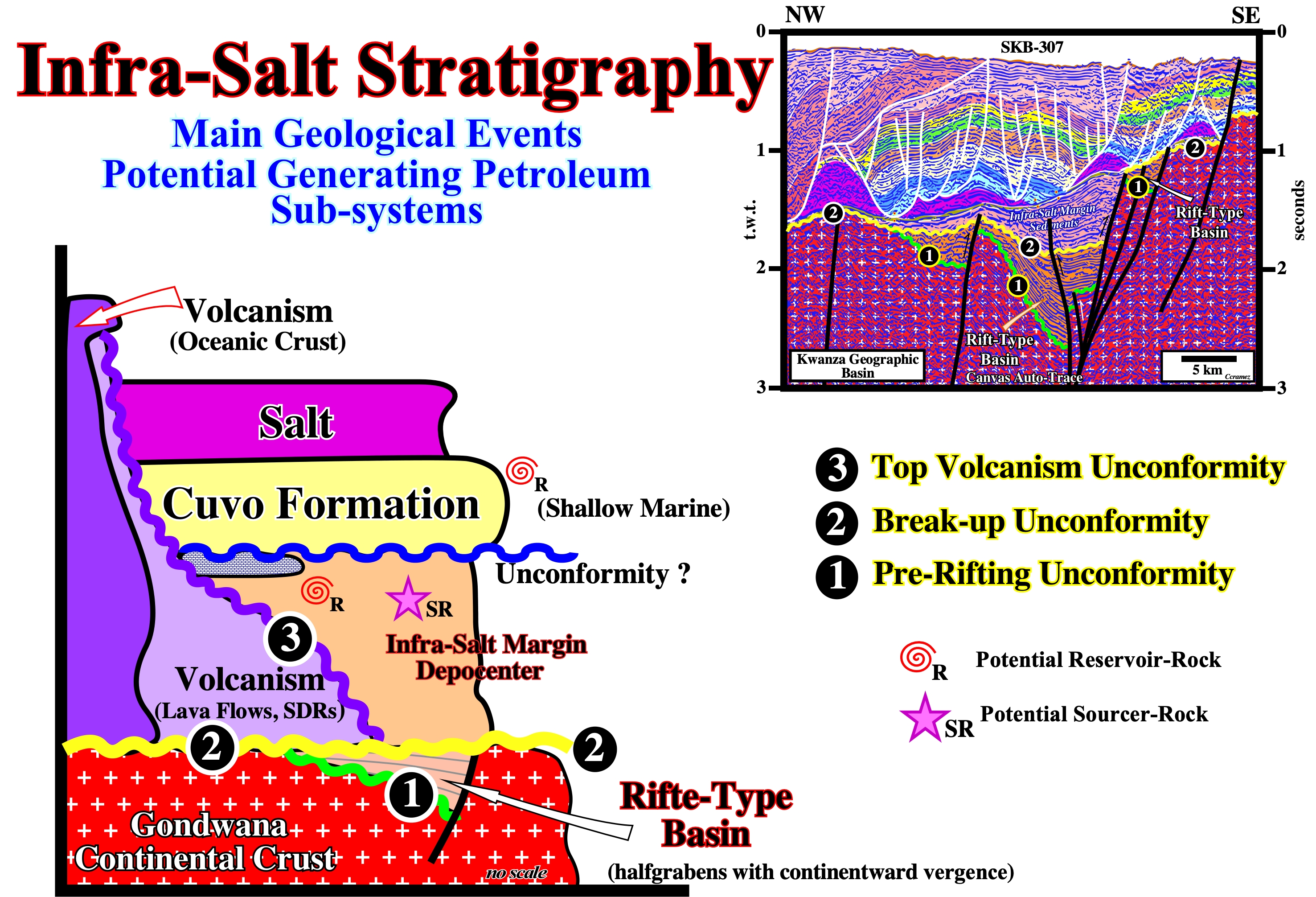
Figure 031- The rift-type basins (in yellow in this figure) correspond to half-grabens with continentward vergence (inclination or divergence) that lengthen the Gondwana continental (white crosses on a red background). The sediments that fill the rift-type basins are, generally, non-marine and associated with three characteristic sedimentary environments (alluvial fans at the base, lacustrine clays and sands or fluvial sandstones at the top). The internal configuration of these basins can be divergent (toward the bordering fault) or parallel. In the first case, the likelihood of generating petroleum sub-systems is low, while in the second, organic rich lacustrine lake sediments are possible (potential source-rock). The break- up unconformity (2) marks the end of the lengthening of the lithosphere. It separates the Gondwana continental crust and the rift-type basins from the sub-aerial volcanism and the overlying infra-salt margin sediments. Within the margin infra-salt sediments, non conformities or unconformities are, sometimes, possible. The salt interval (in red in this figure) is rich in potassium. The brine was enriched by hydrothermalism (reaction between seawater and sub-aerial volcanism). Below the salt layer, sands and shallow water sandstones of the Cuvo formation (dark green) were deposited. Under the sediments of Cuvo formation, locally, thick depocenters >- 500 meters) within which lacustrine source-rocks covered by reservoir-rocks (sandstones and carbonates) are, often, deposited. In other words, regardless the petroleum systems associated with rift-type basins, below the salt interval and Cuvo sandstones, a petroleum system can be found within the infra-salt margin depocenters.
Lava flows, i.e., the synchronous sub-aerial flows of volcanic material (seismic reflectors tilting and thickening seaward) with the break-up of the Gondwana lithosphere cover, by onlapping, the most distal rift-type basins (near the break-up zone). Seaward, the sub-aerial lava becomes oceanic (oceanic crust), since the sub-aerial spreading centers immerse. Under the transgressive sediments (marine sediments deposited in a shallow water) of the divergent margin (sandstones of Cuvo formation and salt), locally, thick lacustrine depocenter with potential source-rocks (clays rich in organic matter) and reservoir-rocks (sandstone, reefal limestone and travertine) deposited. In the Kwanza onshore, as in the offshore Santos Basin (Brazil), an important generating petroleum subsystem is associated with the margin infra-salt sediments and not with the sediments filling the rift-type basins, as suggested in tentative geological interpretation of auto-trace illustrated in the figure below.
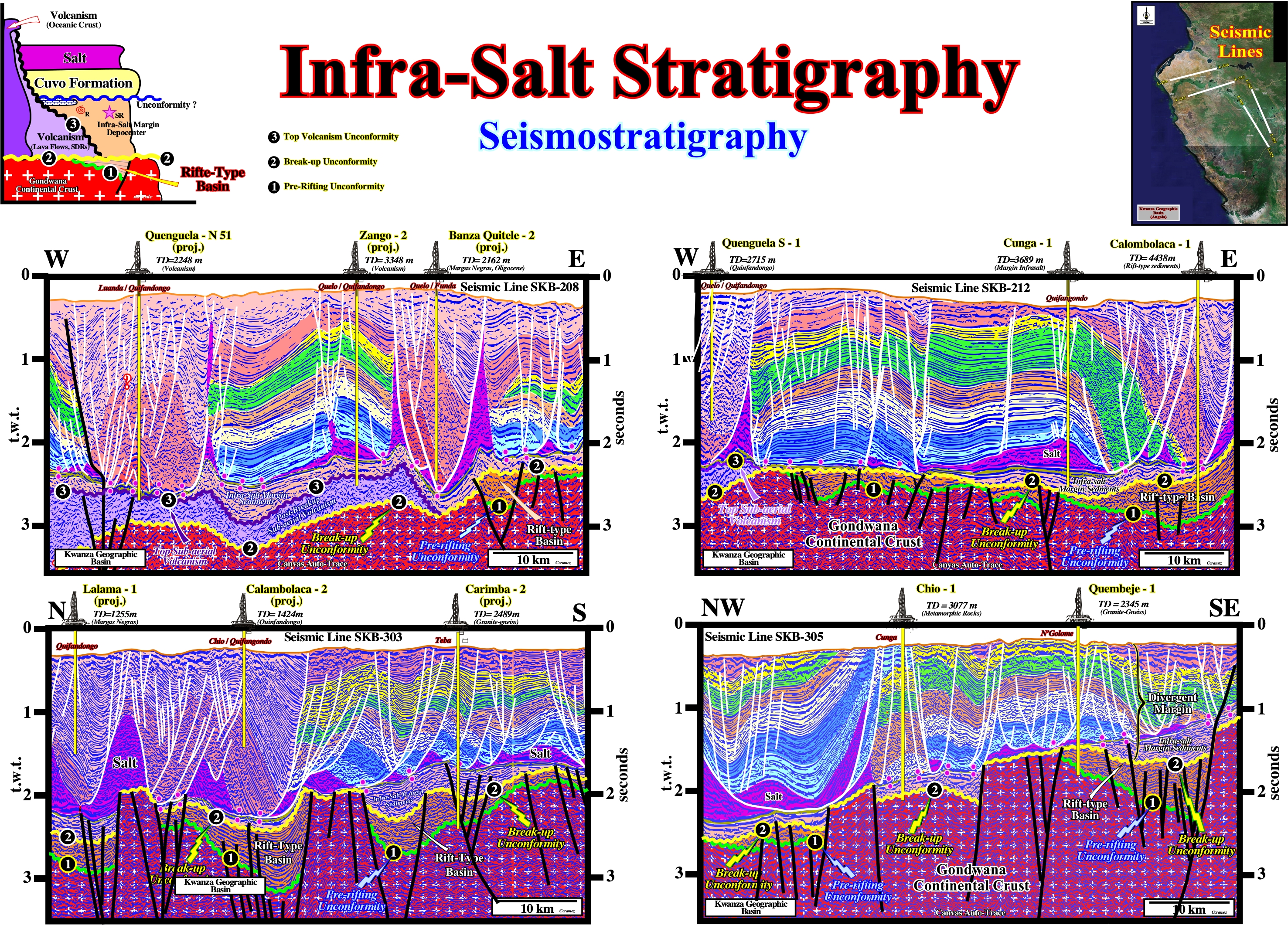
Figure 032- On the tentative geological interpretations of auto-traces (Canvas Draw6) of two North-South seismic line of SKB campaign (2012) taken, recently, by Sonangol, below the salt interval (colored in pink) and Cuvo sandstones (yellow, immediately below the salt and salt welds) depocenters (pink) are evident above the break-up unconformity of the Gondwana lithosphere. The margin infra-salt depocenters, immediately above the rift-type basin, suggests that the associated subsidence corresponds, probably, an isotherm re-equilibrium. The thermal anomaly (cause or effect) caused the lengthening of the lithosphere induced the formation of the rift-type basins corresponds, probably, to a decreasing isotherm equidistance. After the break-up of the lithosphere, it is possible that an rebalancing of isotherms produced a significant thermal subsidence, after the formation of rift-type basins. The same infra-salt seismostratigraphy is recognized on the tentative interpretations of the W-E Canvas auto-traces (see location of the seismic lines on the map illustrated on the upper right corner of this figure).
d) Seismostratigraphy of the Infra-salt Interval in South Atlantic
The infra-salt seismostratigraphy of the Kwanza geographic basin is very similar to that of offshore of Brazil. This, in particularly true, for Santos Basin, where important petroleum reserves were been found in recent years. In the Kwanza geographic basin, the seismostratigraphy of the infra-salt sediments i.e., of infra-salt margin and type-rift basins sediments, is well known. This is, especially, true in onshore Cabinda, north of the Congo River, and in the conventional offshore (< 200 meters) of the outer Kwanza geographic basin (Blocks 6 & 5), where a number of oil wells recognize them, as it can be seen in tentative geologic interpretation of the Canvas auto-trace of a detail of a seismic from Block 6.
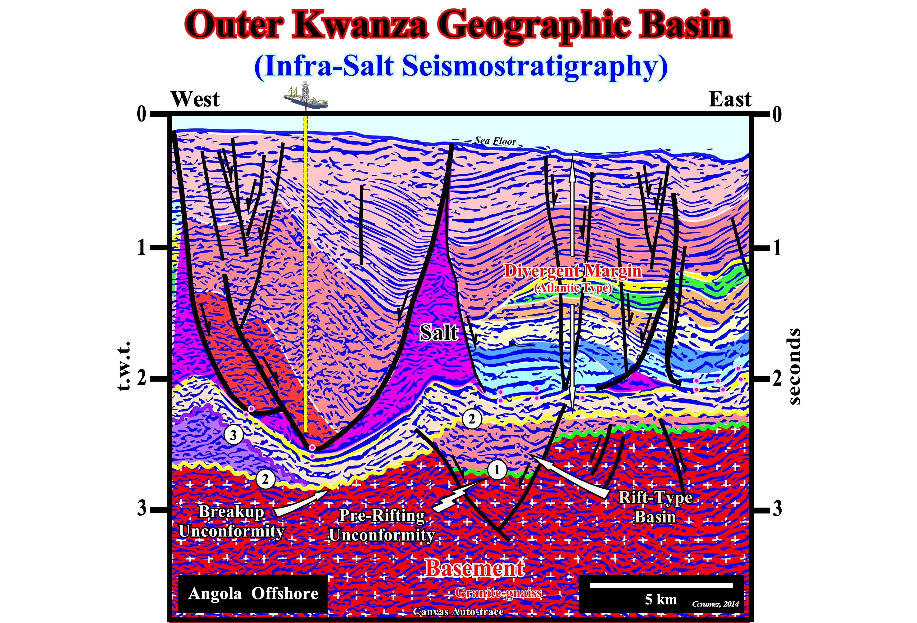
Figure 033- The tectonic disharmony created by lateral and vertical movements of the salt interval is easily recognized. It corresponds, more or less to the base of the salt and salt welds. The salt and supra-salt sediments are highly deformed (extension), while infra-salt sediments are, practically, undeformed. In a depth seismic line, the geometry of disharmony is, more or less, sub-horizontal. In a time line, as the seismic line of this Canvas auto-trace, the tectonic disharmony is, relatively, undulated due to the seismic artifacts (pitfalls) induced by lateral variations of the velocity interval, created by the changes in the thickness of the salt and lateral facies changes (lithology). Immediately below the salt, the thin but continuous seismic interval (colored beige) corresponds to the sands and sandstones of Cuvo formation, whose base, probably, fossilized an unconformity (erosional surface). Between the base of Cuvo formation and the break-up unconformity of the Gondwana lithosphere (2), colored in yellow, two seismic intervals can be recognized. On the left, below the top volcanism unconformity (3), in violet, the post break-up volcanic interval (lava flows), which here seems to form a lava delta. If this is true, a large lake or an epicontinental sea, postdating the breakup of the lithosphere, existed eastward, covering the breakup unconformity and the underlying rift-type basins. In other words, the lava that flowed from the expansion centers continentward reaching the water body (lake or epicontinental sea) froze forming lava deltas. The second interval under the Cuvo sandstones, which fossilizes the lava flows, is a thick clay interval (probably lacustrine shales) with characteristics source-rocks (especially in thicker areas) and carbonated intercalations (potential reservoir-rocks). Below the break-up unconformity, a rift-type basin is easily recognized. Any evident unconformity or disconformity is visible inside. Taking into account the dimensions of this type-rift basin, it is clear that it has no generating petroleum potential.
In order to compare this particular tentative geological interpretation with the geological interpretation of a auto-trace of a seismic line of the Santos geographic basin (Brazil offshore), illustrated in the figure 034, take note that in the above interpretation:
a) The unconformity (1) is the Pre-rifting Unconformity (predating Rift-Type Basins) ;
b) The unconformity (2) is an internal unconformity within Rift-Type Basin ;
c) Between these two unconformities, shales and basal clastics are deposited, sometimes with talc and stevensite ;
d) The unconformity (3) is the break-up unconformity, which is the upper limit of all rift-type basins ;
e) Between the unconformities (2) and (3) are deposited shales, often, with characteristics of source-rocks, intercalated with reservoir-rocks (coquina) ;
f) Between the unconformity (3) and the base of the salt (tectonic disharmony), reservoir-rocks deposited ;
g) Lacustrine source-rocks can occur when this infra-sal margin interval correspond to a depocenter.
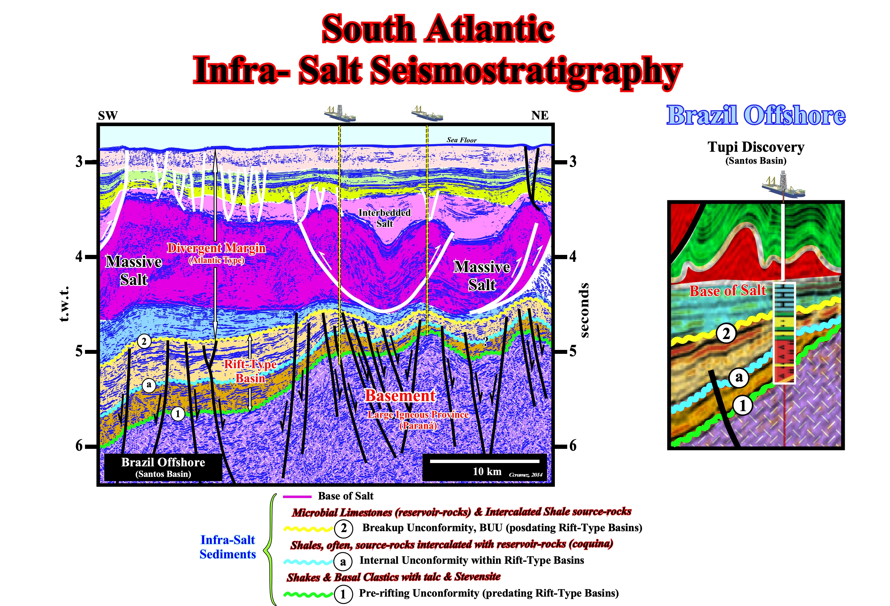
Figure 034- Under the salt interval (in pink) three unconformities are recognized : (2) Break-up unconformity ; (a) Intra rift-type basin unconformity (visible in this tentative) and (1) Pre-rifting unconformity. The margin infra-salt interval (colored in blue) is rich in potential source and reservoir-rocks. The sediments of the rift-type basin and between unconformities (2) and (a) or between between (a) and (1), seem do not have good source-rocks characteristics. However, carbonated reservoir-rocks are possible. As in the inner Kwanza geographic basin, it seems that in Santos geographic basin offshore the main generating petroleum subsystem is associated with the margin infra-salt sediments and with rift-type basin sediments. Here, the basement corresponds to volcanic rocks that are part of Paraná large igneous province. A differential subsidence occurred, mainly, before the break-up of the lithosphere. Virtually, any normal fault was active after the unconformity 2. In the tentative geological interpretation of Canvas auto-trace of the seismic line detail where it was located the Tupi-1 discovery well, the three unconformities are well marked by onlaps and toplaps. The margin infra-salt carbonates are the main reservoir-rocks.
The fundamental difference between the infra-salt sediments of Santos offshore and the Kwanza geographic basin Kwanza is the size of rift-type basins, which are much larger in Santos geographic basin. In the onshore of Kwanza geographic basin, not only they are small, but, also, the internal configuration of the filling is divergent towards the boundary fault, which is not favourable to the development of a generating petroleum subsystem.
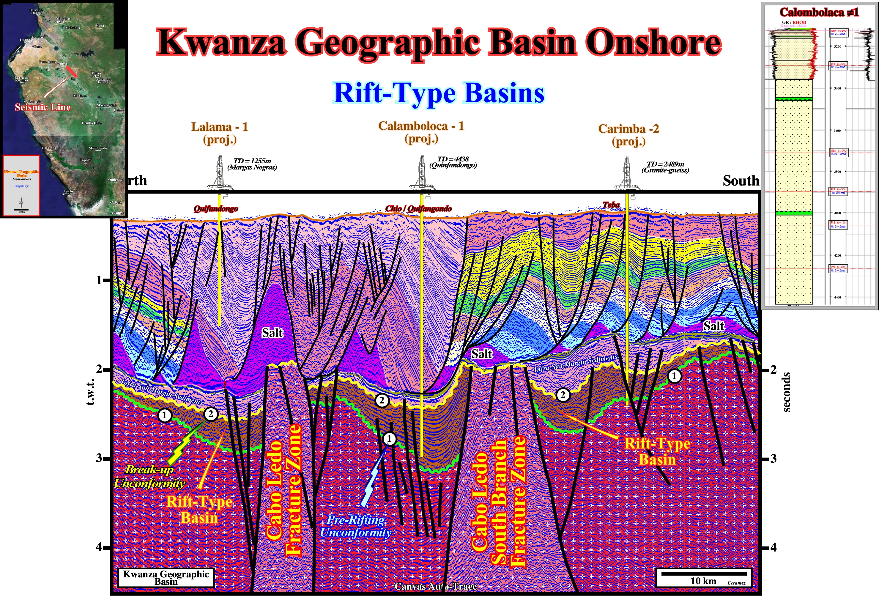
Figure 035- On this tentative geological interpretation of a Canvas auto-trace of a NNW-SSE seismic line of the onshore of Kwanza geographic basin, rift-type basins are easily recognized by their half-graben geomenty. They are individualized by the Cabo Ledo FZ and the Cabo Ledo south branch FZ (see figure 024).The strike of the these rift-type basins seems to be roughly North-South, i.e., oblique to the directiopn of the seismic line. The pre-rifting uncnformity (1) can be easily prcked, as well as the break-uo unconformity (2), which marks the lower limit of the divergent margin basin. Above the break-up unconformity and below the tectonic disharmoiny (bottom of the salt or associated salt-welds), the infra-salt margin sediments are recognized without difficulty. In the northern and southern parts of the auto-trace, the stratigraphy of the overburden is, more or less, normal with a pre-raft (early stage of extension during which the fault block still rests on its original footwall) and raft deformation (faulted blocks of allochthonous overburden that have separated so that they do no longer rest on their original footwall and lie on a décollement layer, which typically consist of salt or a salt weld). On the central part of the auto-trace, the overburden as an abnormal stratigraphy, represented, mainly, by Miocene sediments (Calamboloca depocenter), which correspond to a second rifting phase. In fact, during the evolution of the South Atlantic margins, several rafting phases took place. In Angola onshore and offshore , two main rafting phases are likely. In the first phase, there was formation of pre-rafts and 1st order rafts, while 2nd order rafts were formed in a second rafting phase. Rafts can glide down-dip together inducing the formation of huge depocenters lying directly upon the sub-salt strata or infrastructure .
When the rift-type basins are small, they are filled by lateral terrigeneous influx, which prevent a lake development, and so, the formation and preservation of organic material. A divergent internal configuration means that the rate of extension is compensated by the terrigeneous influx. In such condictions, the depositional water-depth is, practically, zero (0) and the facies sandy. The results Calambola 1 (drilled by Total CAP in Kwanza onshore), which tested a rift-type basin with a divergent internal configuration, does not refute such a conjecture : the well recognize more than 1,000 meters of sandstones, as illustrated in figure 035.