
Part Two
(Geological Conjectures)
Depositional Model
In the sand-shale depositional model illustrated below, P. Vail (1977) considered sequence-cycles are the building blocks of sequential stratigraphy:
" They correspond to a succession of strata (or reflectors), genetically, associated, bounded by two unconformities or by their correlative deep-water paraconformities. They area deposited during 3rd order eustatic cycles, between to consecutive relative sea level falls" (Mitchum et al., 1977)
The stratigraphic model of Exxon (figure 053) did not consensus, particularly, in the geoscientists working in the academies. They thought it was too theoretical, not too detailed, built with too much geological assumptions and not tested enough, which is not quit true. However, it must be said at that time, i.e., in the 70's, the academical geoscientists had not access to the regional seismic lines shot, particularly, in the offshores by the oil companies. On the other hand, such geoscientists should not forget that studying details is fascinating and, even, interesting, but, unfortunately, we learn from generalities and by eliminiation of error with evaluation (P1 →TT→EE→P2, i.e., problem, P1→Testing Theory or Testing Model, TT →elimination of error with evaluation, EE → problem P2, etc, etc.).
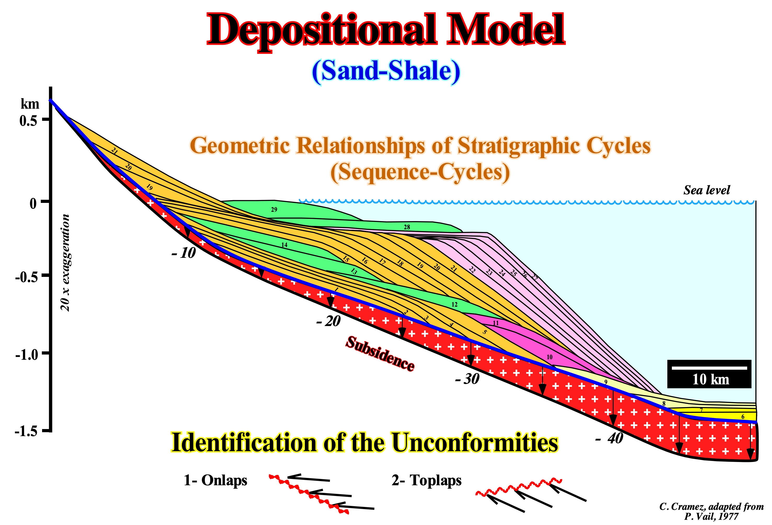
Figure 052- In the field or on a seismic line, a sequence-cycle (stratigraphic cycle) is a succession of genetic reflections bounded by unconformities (or their correlative deep-water para-conformities), induced by strata deposited during a 3rd order eustatic cycle, i.e., by an eustatic cycle, limited between two consecutive falls of the relative sea level*. A 3rd order eustatic cycle has a time-duration between 0.5 and 3-5 My. In this depositional model (sand-shale), P. Vail and his EPR colleagues (Exxon Exploration Production Research) assumed: (i) A given eustatic curve (constructed from absolute sea level changes) ; (ii) An increasing seaward subsidence of the shelf break (or continental edge, in lowstand geological situations), in a linear and regular manner ; (iii) A constant terrigeneous influx (emphasized by the area between two consecutive chronostratigraphic lines) ; (iv) A negligible erosion and (v) A time difference between each chronostratigraphic line of 100 My or, in other words, each eustatic paracycle** has a duration of 100 My. In the proposed model, there are three sequence-cycles limited erosional surfaces, i.e., by unconformities. The oldest sequence-cycle, which encompasses the intervals 1 to 5, is incomplete, as well as the most recent (22 to 29 time lines). The intermediate sequence-cycle (6 to 21) is complete. The two systems tracts groups that, normally, form a sequence-cycle are represented: (A) Highstand systems tracts group (HSTG) and (B) Lowstand systems tracts group (LSTG). During the highstand systems tracts group (HSTG), the sea level is higher than the basin edge, while during the lowstand systems tracts group (LSTG), sea level is lower than the basin edge. In the lowstand systems tracts group (LSTG), the basin has no shelf, whereas in the highstand systems tracts group (HSTG), the basin has a shelf except during the final part (2nd phase of development of the systems tracts sub-group denominated highstand prograding wedge, HPW). In the highstand systems tracts group, two sub-groups are identified: (a) Transgressive Interval (TI), colored in green, and (b) Highstand prograding wedge (HPW), colored in orange. The former has a retrogradational geometry, while the latter has a progradational geometry. The lowstand systems tracts group (LSTG) is formed by three sub-groups of systems tracts, which from the bottom up are: (a) Submarine Basin Floor Fans (SBFF), colored in yellow ; (b) Submarine Slope Fans (SSF), colored in beige and (c) Lowstand Prograding wedge (LPW), colored in violet. The unconformities, which limit the sequence-cycles, are, relatively, easy to identify near the continental edge by the seismic surfaces defined by the reflector terminations (lapouts): (1) Onlaps and (2) Toplaps by erosion or by non-deposition. In deep-water, where erosion is negligible, the unconformities pass, down-dip, to a correlative Para-conformities. As suggested in this geological model, except for the submarine fans (basin and slope), deposited during significant relative sea level falls, all other sub-groups of sedimentary systems tracts require a relative sea level rise (marine ingression) to create the space available for sediments, i.e., shelfal accommodation. The sedimentary particles are deposited during the stability period of relative sea level occurring after each marine ingression. Globally, the shoreline moves continentward during marine ingressions, without deposition and then moves to seaward as the sedimentary particles are deposited.
* Local sea level, referenced at any point on the Earth's surface as the sea-floor or the base of the sediment (top of continental crust). It is the result of the combined action of the tectonics (subsidence or uplift of the sea floor) and the absolute sea level, which is supposed to be global and referenced to the Earth's center (via satellite measures).
**An eustatic paracycle is a relative sea level rise followed by a period of stability before a new rise without any relative sea level fall between.
In this depositional models, geoscientists should not confuse the relative sea level with absolute (eustatic) sea level. The relative sea level is local and referenced to any fixed point on the Earth's surface, which can be the base of the sediments (top of the continental crust) or the sea floor. The absolute (eustatic) sea level is supposed to be global and is referenced to the Earth's center. The relative sea level is the result of the combined action of absolute sea level and tectonics (subsidence or uplift of the sea floor). The absolute sea level is the result of the combined action of: (i) Tectono-Eustasy (controlled by the volume variation of the ocean basins in association with oceanic expansion following the break-up of the supercontinents) ; (ii) Glacio-Eustasy (controlled by the variation of water volume of the oceans as a function of the amount of ice, assuming the amount of water, in all its forms, is constant since the formation of the Earth, around 4.5 Ga) ; (iii) Geoidal-Eustasy (controlled by the distribution of ocean water caused by the variations in Earth's gravity field, i.e., where gravity is stronger than normal, sea level is thrown to the Earth's center) and (iv) Steric sea level rise or thermal expansion of the oceans (if the temperature increases, the density of the water decreases, and for a constant mass, the volume increases). During a given geological time, the combination of the eustatic curve (curve the absolute sea level changes) and tectonic (subsidence of the sea floor, when the predominant tectonic regime is in extensional or uplift of the sea floor, when the predominant tectonic regime is compressional) gives the curve of the rate relative sea level change.
Notice that along each depositional surface (represented in the above depositional model by a chronostratigraphic line), several breaks or changes in the inclination can be observed:
(i) Bayline (in the highstand systems tracts) ;
(ii) Depositional Coastal Break, which corresponds, more or less, to the shoreline or delta front ;
(iii) Delta Slope Bottom Break ;
(iv) Shelf Break (top of the continental slope) and
(iv) Abyssal Plain Break (bottom continental slope.
Contrariwise to the old geological principle of Original Horizontality**, along a depositional surface, between inclination breaks, horizontal and oblique realms of deposition are possible. Coastal plain, platform and abyssal plain sediments are deposited, more or less, horizontally. However, alluvial fan, prodelta, continental slope and slope fan sediments are deposited with an oblique angle. The depositional angle is, mainly, dependent of the stability of the associated slope, which is function, among others factors, of the terrigeneous influx, water depth, climate, etc.
** This geological principle says the sedimentary layers were deposited in lateral continuity. They thin out and disappear either by downlaps or by onlaps against the edges of the deposition zones. This principle was, recently, upgraded. In fact, nowadays, we know that bedding planes are chronostratigraphic surfaces composed by different geological environments with different deposition inclinations. Alluvial deposits (upstream of the bay line), prodeltas, particularly, in the deltas Gilbert-type delta are not deposited horizontally. There are other geological principles that a geoscientists must always have in mind : (i) Principle of Composition, a rock represented by fragments in other rock is older than the rock which contains them ; (ii) Principle of the Intersection, the latest veins displace the oldest veins ; (iii) Principle of Intrusion, an intrusive igneous rock is younger than the rock it penetrates ; (iv) Principle the Superposition, in a stratigraphic column, the sediments undeformed or slightly deformed, the oldest layers are the bottom and the most recent are successively upward ; (v) Principle of the Succession of Fossils, the distribution of fossils in rocks is aleatory, they follow a defined vertical succession ; (vi) Principle of Goguel, during deformation, the volume of sediment remaining more or less constant ; (vii) Principle of Walther, the facies (lithology) followed vertically in conform strata, can be followed laterally in adjacent environments ; (viii) Principle dextrogyre says if a reference system rotates in a clockwise sense, the deflection of an object (Coriolis effect) is to the left ; (ix) Principle of the Carbonate Bucket, says the growth of a rimmed carbonate platform is determined by the growth of the aureole ; (x) Principle Uniformitarianism says geological changes are due, mainly, to the same processes and continuous change which can be observed at present time ; (xi) Principle of Ochkam, plurality should not be invoked without requiring "non Pluritas is ponenda sine necessita".
Consequently and to conclude this chapter, we can say that at macroscopic scale, and particularly, at the scale of the seismic lines, taking into account the seismic resolution, three sub-areas can be considered in a depositional surface : (i) A dipping subsurface (surface 1) ; (ii) A subhorizontal surface downdip of the dipping surface (surface 2) and (iii) A subhorizontal surface updip of the dipping surface (surface 0) (only the surfaces (0) and (2) can be flattened.
a) Assumptions
The depositional model proposed by the geoscientists EXXON oil company assumes nine (9) main geological assumptions:
a.1) Eustasy is the main factor controlling the cyclicity of deposits.
Eustasy is difficult to define. There is no consensus on this subject. Eustasy (or Eustatism) is, often, considered, as “simultaneous and global sea level variations”. Differentiated from local relative sea level variations, eustasy can be considered as sea level variations regardless of their causes (Mörner, 1977). Absolute sea level is, often, referenced to the Earth's center.
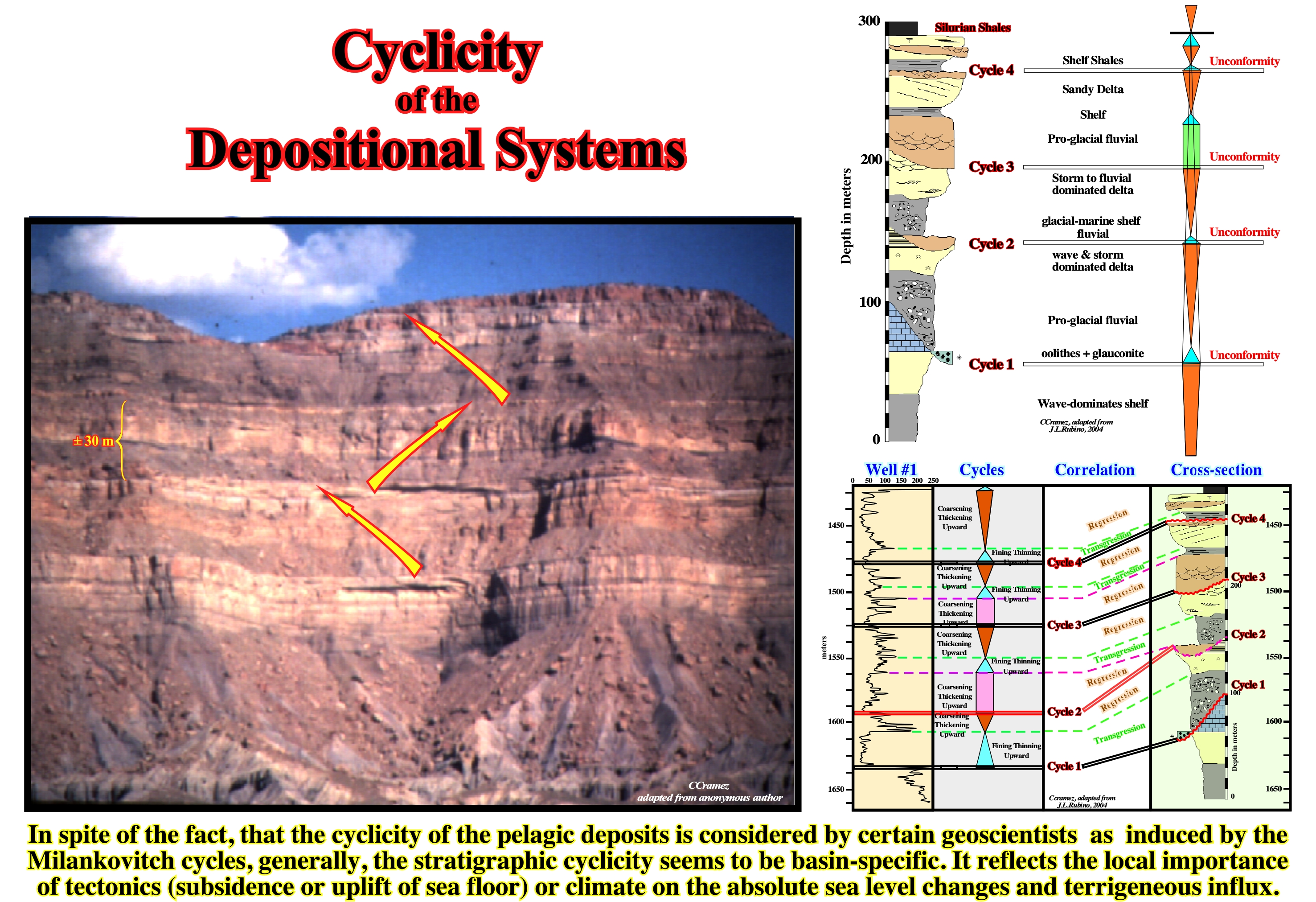
Figure 053- As illustrated on this photograph, the physical stratal patterns strongly suggest that depositional systems are cyclic. Since the advent of Geology as natural science, geoscientists have advanced several hypotheses to explain such cyclicity Eustasy has always been considered as the most likely cause of the cyclicity of depositional systems (Maillet, Lavoisier, Lemoine, Burrolet and, more recently, the Exxon geoscientists). This hypothesis was tested many times, but so far, it has resisted to all refutation tests. Eustatism, i.e., global sea level changes can apply only to the sediments deposited under the influence of the sea. At a specific location and along time, non-marine sediments, in particular, those deposited landward of the bayline are outside of the eustatism scope. High frequency stratigraphic cycles (10 - 100 ka) show, often, an alternation of dynamic processes (proximal or energetic) and non-dynamic (distal - pelagic). When the sedimentation is contemporaneous of deformation, these processes tend, respectively, to fill or cover the topography induced by tectonic and erosional agents. As a result, strata thickness increases and is isopach on growth structures. High resolution kinematic studies of the growth of structures (folds and faults) assuming sedimentation always fills the topography, allow do not confuse the sedimentary cyclicity with tectonic cyclicity. The cyclicity of the depositional systems recognized on the ground is depicted on stratigraphic cross-sections. The sections illustrated on this plate comes from an Upper Ordovician glacial interval, i.e., from an environment in which eustasy is meaningful. In spite of that, four stratigraphic cycles are quit evident. They are bounded by erosional surfaces, which truncate, locally, the underlying strata putting in vertical abnormal superposition and lateral juxtaposition sediments withdifferent facies (lithology) and environments. In addition, within each cycle, it is possible to identify a lower thinning and fining upward package, which is overlain by a coarsening and thickening upward package. Eustasy, in this particular example (glacial deposit), for many geoscientists, cannot be directly invoked as the main cause of the cyclicity. The landward and seaward movement of the glacier is probably the more likely cause of the observed cyclicity, with glacial erosion bounding the cycles. Eustasy explains quite well the cyclicity observed in marine sediments..
a.2) Eustasy, Subsidence or Uplift, Accommodation, Terrigeneous Influx and Climate are the main geological parameters that determine the configuration of the strata.
In the proposed depositional model (figure 052 & 054), assuming that there are 100 ky (one hundred thousand years) between each chronostratigraphic line (1-29), three sequence-cycles (stratigraphic cycles) are represented. However, only the sequence-cycle formed between time-lines 6 and 21 is completed. Looking carefully to the unconformities (erosional surfaces induced by significant relative sea level falls) different downlap surfaces and seismic surfaces, defined by terminations of time lines (chronostratigraphic lines), can be recognized.
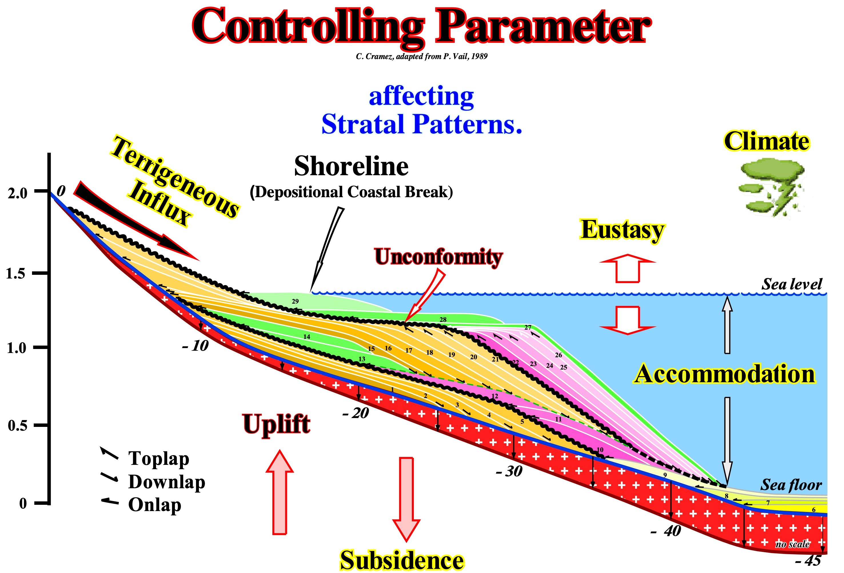
Figure 054- The main parameters controlling the depositional systems deposited in a sequence-paracycle (lateral association of synchronous and genetically linked depositional systems) are indicated in this sketch: (i) Eustasy (absolute or eustatic sea level changes) ; (ii) Tectonics (subsidence or uplift of the sea floor) ; (iii) Terrigeneous Influx (supply of sedimentary particles) and (iv) Climate. The combined effects of tectonics (subsidence of the sea floor, when sediments are lengthened or uplift of the sea floor, when sediments are shortened) and eustasy (changes of the absolute sea level) control the available space for sediments (mainly shelfal accommodation). Sedimentary uplift occurs during compressional tectonic regimes (characterized by σ1 horizontal*). Subsidence occurs, mainly, during extensional tectonic regimes (characterized by a vertical σ1). Seaward of the continental edge, which may be or not the basin edge, there is, generally, sufficient space available for sediments, especially when the basin has a shelf. At the level of a sequence-cycle, accommodation changes may be positive (relative sea level rise) or negative (relative sea level fall). In the first case, there is deposition. In the second, there is erosion and, often, formation of a unconformity (when the relative sea level fall is significant and put the sea level below the basin edge. The terrigeneous influx controls how much space available, created by a relative sea level rise, is filled. It controls, also, the seaward displacement of the shoreline (roughly the depositional coastal break), as it is the case during the transgressive interval of a sequence-cycle (transgressive systems tract of certain geoscientists). Tectonics and climate control the quantity and type of sedimentary particles. Each of these parameters has a signature and a certain rate of change, which can be recognized in the rocks and, partly, on the seismic data. P. Vail, like most geoscientists, believes that eustatic changes have a higher rate of change than other parameters. In other words, he believes that eustasy controls the geometry and the cyclicity of the sedimentary intervals. De Maillet and Lavoisier, in the seventeenth century, were, certainly, the earliest scientists to consider eustasy as the main responsible for the cyclicity of coastal sedimentary deposits. In the long term (continental encroachment cycles and 1st order eustatic cycles, whose duration is greater than 50 My) the absolute sea level changes are induced by the tectono-eustasy created by the break- up of the the supercontinents. In 2nd order eustatic cycles (duration between 3-5 and 50 My), relative sea level changes seem to be induced by basement movement mechanisms (tectonic subsidence) operating over periods of tens of millions of years. In sequence-cycles, the causes of eustatic variations (3rd order and higher) are still very controversial, but glacio-eustasy (controlled by the glaciation/deglaciation cycles or loading and unloading induced by the addition and removal of ice from the glacial caps) seems to have a predominant influence. In general, absolute sea level changes are responsible for the cyclicity of relative sea level changes, while tectonics (subsidence or uplift of the sea floor) determine the amplitude of accommodation changes.
(*) The greater ellipsoid axis of the effective stresses (combination of the geostatic pressure σg, hydrostatic or pore pressure σp and tectonic vector σt).
a.3) Subsidence & Terrigeneous Influx has less influence than the Eustasy.
Changes in subsidence and terrigeneous influx (supply of sedimentary particles) are slower than eustatic changes.
a.4) Terrigeneous Influx is constant in Time & Space.
Sediment supply considered, often, as synonym of terrigeneous influx is a quite wrong expression. The noun sediment comes from the Latin word "sedere", meaning “to settle.” In other words, a sediment consist of terrigeneous material (originated on land) deposited in either terrestrial, marine, lacustrine environments or a deposit of biological material, originated in the water body. This is why, geoscientists use the expression terrigeneous influx or supply of sedimentary particles.
a.5) Subsidence increases gradual and lineartly basinward.
a.6) The sedimentary intervals have a great completness.
The completness is the relation between the effective time of deposition and total geological time. If the time between two consecutive unconformities is, for instance, 3.0 My and the effective deposition time is 1.0 My, the sedimentary completeness is 0.3. In turbidite systems, the completeness is quite small, but the preservation is great. The deposition time of a deep turbiditic lobe (submarine basin floor or slope fan) is, practically, instantaneous (in geological terms), while the time span between two consecutive lobes, during which, practically, nothing happen (from the point of view of deposition), can be thousands of years or more. The knowledge of completeness is essential to determine the sedimentation rate of a given sedimentary interval.

Figure 055- Three questions come, always, to the spirit of geoscientists: (1) How long is a sedimentary layer deposited ? ; (2) How long does a given stratigraphic section deposit ? and (3) In comparison to the total deposit duration of a stratigraphic section, how long is there, actually, deposition ? The answers to the first two questions are, relatively, easy: a) A beach deposit lamination is deposited in about one second ; b) A layer of HCS ("cross-stratification"), characteristic of storm deposits, is deposited in a few minutes ; c) A turbidite layer is deposited in a few hours ; d) Flood deposits, such as the Scablands*, are deposited in a few weeks ; e) The glacial varves deposit in 1 year ; f) One centimeter of pelagic sediment deposits in about 103 years ; g) A continental encroachment sub-cycle deposits in 10/20 x 106 years ; h) A continental encroachment cycle deposits in 100-200 x 106 years. In 198, on this subject, P. M. Sadler showed that the duration of a deposit is inversely proportional to the sedimentation rate, i.e., higher is the sedimentation rate shorter is the deposition period. From this, it can be deduced that most periods of no deposit escapes us, which led Ager (1984) to consider that sedimentary records correspond to short periods of terror separated by long periods of calm, where nothing happens. As all geoscientists know, in all stratigraphic systems, whether they are Silurian or Cretaceous, deposits are episodic, incomplete, and with numerous erosion and non-depositional hiatus. The deposits do not translate in any way the equivalent duration of geological time. In the stratigraphic sections, whether they are deep-water or not, the time of no deposition and erosion is, almost always, greater than the actual deposition time of the preserved sediments. As illustrated in this figure, this is particularly true in turbidite deposits and coastal deposits. In the upper part of this figure, in the stratigraphic models (progradational shoreline, i.e., during sedimentary regressions and turbidite depositional systems) it is important to note in the upper part of each section the duration of the periods of non-deposit is largely higher to the periods of deposition. Most of the geological events that occurred during these periods were not preserved. The completeness of a deposit is given by the ratio of the deposition time to the total time (depositional time plus hiatus). Turbidite deposits and, in particular, submarine basin floor fans have a very small completeness. The deposition time of each turbidite layer is, geologically, instantaneous, but the time between two consecutive turbidite currents, during which the pelagic shales are deposited, is very large, sometimes more than 1 My. In a submarine basin floor fan, composed of 100 turbidite layers and pelagic shales, if which each turbidite layer has a thickness of 20 cm and each pelagic layer has a thickness of 5 cm, the total thickness is of 2500 cm. As the average deposition rate of pelagic shale is, say, 5 cm/1,000 years and the turbiditic currents are instantaneous stratigraphic events, it can be deduced: a) Total deposition time was 100,000 years and b) The frequency of turbiditic currents is 1,000 years (two-thirds of the sedimentary interval has been deposited by instantaneous events). On the other hand, it is important not to forget most of the sediments associated with the different geological events occurring during the deposition periods are not preserved. In fact, the preservation of the stratigraphic sections is related to: (i) Amplitude; (ii) Frequency of stratigraphic events and (iii) Depositional environment. The stratigraphic events most represented in the stratigraphic records are those that have normal or low frequency, i.e., occurring sporadically. In terms of frequency, as said above, within a sequence cycle, the submarine basin and slope fans are very significant because the turbidite levels contrast sharply with pelagic intervals between them. Pelagic stratigraphic intervals are events of normal frequency, whereas turbidite intervals are associated with events, geologically, instantaneous.
* Deposits and erosions associated with flooding caused by the behind retention rupture of lakes associated with the Pliocene/Pleistocene glaciers of Canada.
a.7) There is no erosion during the relative sea level falls.
a.8) The time interval between each chronostratigraphic line is 100 ky.
What means 100 ky (hundred thousand years) in geological time, knowing that in mathematical terms, an instantaneous event, represents a time change of about 1/100 of the total time? In the Phanerozoic time scale (approximately 600 million years), that means that a geological event with a time duration of around 6 million years (approximately the time duration of a 3rd order eustatic cycle) can be considered as instantaneous. Subsequently, 100 ky, i.e., the time-interval between each chronostratigraphic line of the proposed Exxon depositional model is, in geological terms, instantaneous. A geological event appears in the geologic scale as snapshot, while in an expanded scale it appears as an event with a finite speed. For the Phanerozoic (600 Ma - 0 Ma), the concept of geological event proposed by Gretener (1967) is, reasonably, consistent with the geological resolution we have today and that is, at best, of 1 My order (1 000 000 years). Assuming the stratigraphic record with petroleum potential range between 1 and 1,000 My, geological processes have lengths between 10 and 10 ka, i.e., 1/100 of the total time. This period does not take into account the "myopia" of geoscientists, which increases as we descend into the depths of geological time.
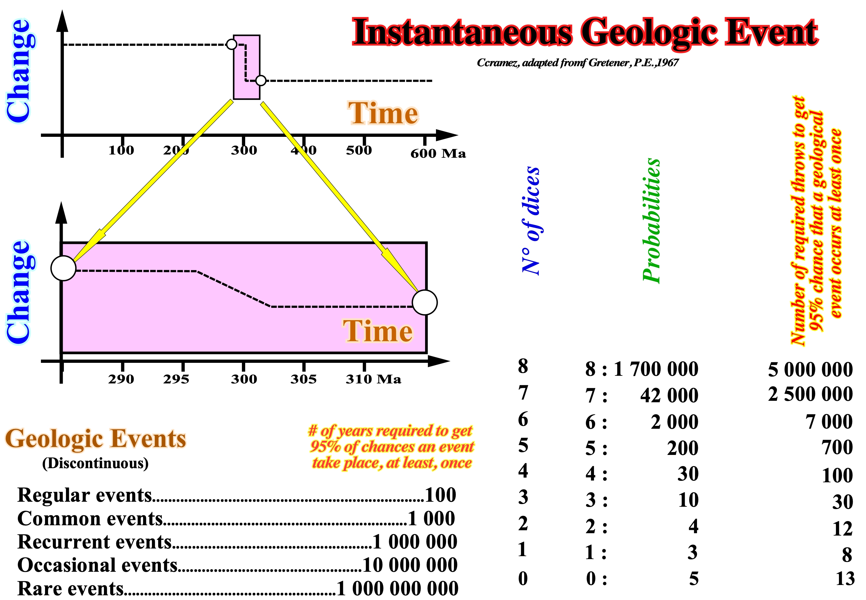
Figure 056- As illustrated above (upper left part of the figure), mathematically speaking, for the Phanerozoic, which time-duration is, more or less, 600 My, a geological event with a time duration of 6 My is considered as instantaneous, since its time-duration is around 1/100 of the total time. On a change-time cross-plot, the time of the geological event corresponds to a vertical line, while on a dilated scale it,¨ is discernible, since it corresponds to a sloping line. In an octahedron dice game (its eight faces are triangles and are numbered 1 to 8), the probability of get 8 times the face 6, when all the dice (eight dice) are thrown is 1 in 2 x 10⁶ of throws. As the number of throws increases, the probability of obtaining a throw with an eight-sided 6 increases, too. Theoretically, as illustrated on this figure, there is a 95% probability of obtaining, at least once, eight (8) faces with the number six in a total of about 5 million throws and 95% of probability of not obtaining at least one time, no face with number six in 13 throws. All this means that: (i) At the human scale (2-3 generations time), a small probability of occurrence of a certain geological event is considered as an impossibility, although there is no natural law that prevents this event from happening and (ii) What is, practically, impossible, on a human scale (a collision of an asteroid with the Earth, for example) is just unlikely at the geological scale. In order to understand the meaning and importance of a geological event, it is equally important not to forget that a stratigraphic system, such as Silurian, is occasional and incomplete. It has numerous gaps (periods without deposition or erosion). In general, stratigraphic systems do not translate the equivalent geologic time interval, but just the time during which deposition occurred. The sedimentary completeness of a stratigraphic interval, which certain geoscientists call sedimentary integrality (ratio of actual deposition time to total interval time) and the preservation of a deposit are important elements.
All geoscientists know that the sedimentary completeness of a turbidite layer is, more or less, 1, while that of a pelagic clay is largely lower than 1. A beach lamination deposit is deposited, more or less, in a second. A hummocky cross stratified layer (HCS layer), characteristic of storm deposits, is deposited in a few minutes. A turbidite layer deposits in a few hours. Flood deposits, such as the Canadian Scablands (deposits and erosions associated with flooding caused by the rupture of the retention of lakes located behind Pliocene-Pleistocene glaciers), are deposited in a few weeks. The glacial varves deposit in a year. One centimeter of pelagic sediments is deposited in about 103 years. A continental encroachment sub-cycle deposits between 10 and 20 x 106 years. A continental encroachment cycle is deposited at 100 and 200 x 106 years. Imagine a stratigraphic interval composed of 100 layers of turbidite and pelagic clay, where each turbidite layer has a thickness of 10 cm and each pelagic layer has a thickness of 5 cm. The total thickness will be 1,500 cm. Since the mean deposition velocity of the pelagic clays is about 5 cm/1000 years and the turbiditic currents are instantaneous stratigraphic events, we can say: (i) The total deposition time is 100 ky ; (ii) The frequency of the turbidite currents is 1 ky ; (iii) Two-thirds of the sedimentary interval was deposited by instantaneous events whose frequency is one event per thousand years ; (iv) In 10 million years, 10,000 geologically instantaneous events can deposit a 1,500 m thick section.
Due to the rate of renewal, it is possible to classify the geological events in two main groups: (I) Casual events, i.e., that occur at least once every 100 million years (the duration of the event is about 1 million years) and (ii) Rare events that occur at least once in 1000 million years. Accordingly, the event duration is from about 10 Ma (1/100 of the total time). A rare geological event is defined as an episode whose renewal fee, throughout the history of Earth is very low (2-5 times) and for which no physical law allows to bring it into doubt. Taking into account the amplitude of the time intervals considered in Geology, such a concept is, of course, relative.
a.9) In geologic time, the building blocks of the stratigraphic intervals (sedimentary bricks) are the sequence-cycles.
Sequence-cycles are instantaneous (snapshots). They correspond to depositional catastrophic events. The eustatic cycles associated (3rd order cycles) to sequence-cycles last between 0.5 My and 3.0-5.0 My years.
In the hierarchy of stratigraphic cycles, proposed by Duval et al. (1993), four main levels are considered:
(i) Continental Encroachment Cycle ;
(ii) Continental Encroachment Sub-Cycle ;
(iii) Sequence-Cycle and
(iv) Sequence-Paracycle.
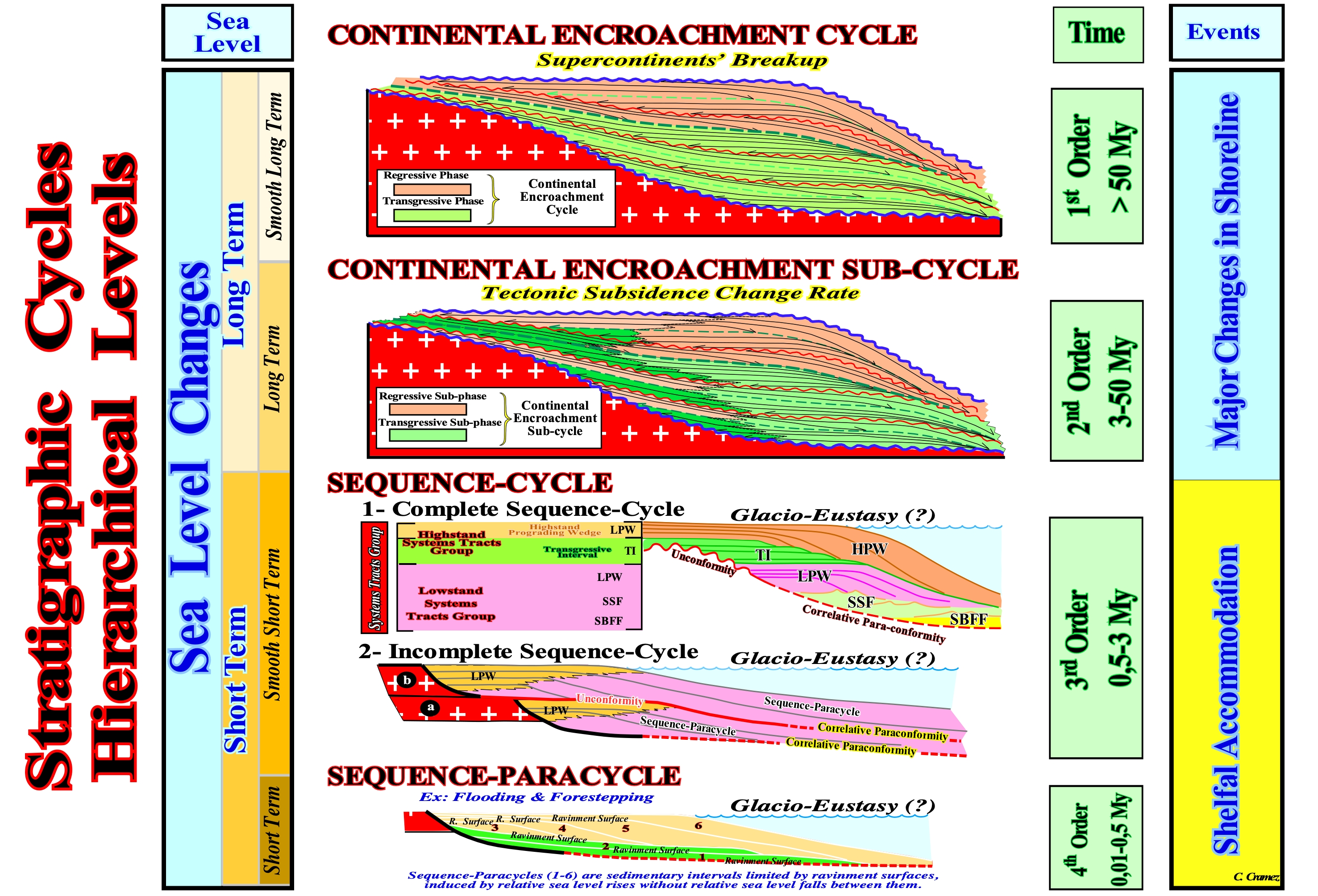
Figure 057- Continental encroachment cycles are induced by 1st order eustatic cycles, whose time-duration is always greater than 50 My. These eustatic cycles are a consequence of the break-up of the supercontinents. During the dispersal of the individualized continents, the volume of the oceanic ridges increases, which diminishes the volume of the ocean basins. Assuming the amount of water, in all its forms, is constant since the Earth's formation, around 4.5 Ga, the absolute (eustatic) sea level (referenced to the Earth's center) rises. On the contrary, during the aggregation of the continents, to form a new supercontinent, the volume of the oceanic ridges decreases, increasing the volume of the ocean basins, which causes the absolute sea level to fall. Continental encroachment sub-cycles are induced by 2nd order eustatic cycles, whose time-duration varies between 50 My and 5-3 My. These eustatic cycles are associated with the rate of tectonic subsidence (total subsidence decreased from the effect of isostatic compensation and increased by the effect of compaction), which varies with the velocity of oceanic expansion (sea floor spreading). The tectonic subsidence can be made by: A) Lengthening, as is the case during the formation of rift-type basins (the lengthening of the lithosphere decreases its thickness, i.e., it subsides in relation to the thicker and undeformed lithosphere) ; B) Cooling, during the lengthening of the lithosphere, the upper surface sinks, while the lower limit rises, which forces the underlying asthenosphere to rise to replace the lithosphere of the thinned mantle (after the lengthening phase, the upper asthenosphere cools and returns, again to the lithospheric mantle, which is denser than the asthenospheric mantle ; such cooling causes significant subsidence) ; C) Charging, Sedimentation, Thrust Stacking and Folded Belt Formation induce crustal depression and subsidence (in the case of sedimentary depocenters, these follow the sinking of the underlying lithosphere, however, in the case of thrusting and folded belts, the sinking occurs, mainly, in the lithospheric crust adjacent to the deposition). Sequence-cycles are associated with 3rd order eustatic cycles, which are, basically, the result of the combination of absolute sea level and tectonic changers. The sequence-paracycles, that are induced by eustatic paracycles are, also, associated with glacio-eustasy, but, above all, with successive relative sea level rises without sea level falls between them.
b) Strata Implications
There several stratal implications in the proposed Exxon depositional model:
b.1) The stratal surfaces represent, typically, an hiatus (time gap), relatively small.
Stratum is the name given to each of the layers in which the sedimentary, pyroclastic and metamorphic rocks (when these are the consequence of sedimentation processes) are divided. However, horizontal and uniform strata evolve under the action of tectonic stresses, with changes in structure behavior (inclination and even inversion) and shape (folding). In addition, some strata may have, from their deposition, different dips between them and different thicknesses, as is the case in a cross-bedding. The genesis of cross-bedding is quite simple, when associated with the deposition of sedimentary particles transported by rivers when they reach the foothills of a mountain chain and form alluvial fans, terraces and other forms of accumulation. These sediments are arranged according to gravity and intersect with each other due to the changes in river courses that deviate from the great floods. These are often sporadic as is the case in arid climates, simply because the previous flood has produced an accumulation that the river must contour to deposit the sediments with different inclination, direction and thickness. Over time, these deposits of sand or shales can be consolidated and form sedimentary rocks, maintaining the original arrangement of the sediments that formed these deposits.
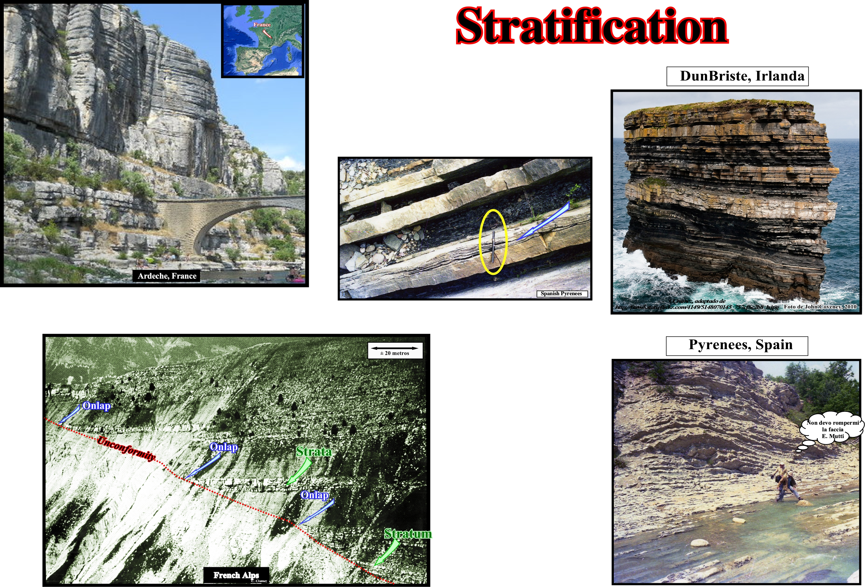
Figure 058- As illustrated in the photographs of the Ardeche River (France), Dunbrooke stack* (Ireland), French Alpes (sandstones of the Annot formation) as well as the turbidites of Spain onshore (Pyrenees), the sediment stratification is the vertical stacking of a set of strata, i.e., a stacking of rock levels with consistent internal characteristics distinguishing them from contiguous levels. Clastic sediments deposited in more or less horizontal horizons are called strata or beds (layers). This arrangement results from the tendency of water and also wind to spread sedimentary particles of the same type at relatively thin levels over a large area and over a period of similar environmental conditions. When environmental conditions change at the deposition site several things can happen: (i) Different types of sedimentary particles can be deposited at the top of the previous layer ; (ii) There may be a period of time during which sedimentary particles do not settle (hiatus) ; (iii) The original layer can be eroded, etc. However, as the depositional environment is the same, the type of deposited clasts** (sedimentary particles) tends to be more similar within the same level than at two different levels. Sediments tend to be more similar within the same layer than in different layers. However, lateral continuity has limits. A particular layer may be, relatively, thin and pinchout (disappear laterally) without leaving any particular record of the deposition time in the area of pinchout. The type of sediment that characterizes one layer may change laterally and gradually in another type within the same level, suggesting the depositional environment may, also, change, gradually and laterally. Certain combinations of sedimentary environments favor abrupt discontinuities of sedimentary levels of the same type. The sands and shales deposited by a river are, in general, discontinuous, due to the repetitive periods of flooding. Other sedimentary environments are more conducive to the continuity of the layers. The pelagic shales deposited in the deep parts of a basin exhibit a great lateral continuity. Stratification characterizes, always, a lateral continuity much greater than vertical. Lamination and stratification are not synonymous. Lamination is a succession, at small scale, of thin horizons (called laminae), which occurs in sedimentary rocks. Lamination is, usually, smaller and less pronounced than the stratification. Laminations are regarded, often, as planar structures one centimeter or less thick, while the beds (stratification) are larger than one centimeter. However, structures from a few millimeters to several centimeters have been described as laminae. A sedimentary rock can have both laminae and beds (layers). On the seismic lines, since the seismic resolution is of the order of two or three tens of meters, it is evident that the reflectors do not correspond to a stratum, but to interfaces between sedimentary intervals of significant thickness with different acoustic impedances. The stratification observed on the seismic lines that many geoscientists call seismic stratification has very little to do with the sediment stratification. Likewise, it should not be forgotten that to have deposition of sedimentary particles and stratification there must exist accommodation (available space for sediments), generally, created by a marine ingression (relative sea level rise). However, during the marine ingression, which moves, continentward, the shoreline with the formation of a ravinement surface, there is no deposition. The deposition of the sedimentary particles occurs during the stability period of relative sea level (result of the combined action absolute sea level, referred to the Earth's center of the Earth and tectonics) that follows the rise of the relative sea level, during which the shoreline moves seaward as the sedimentary particles settle down to form a sedimentary regression. When a geoscientist says that there is a relative sea level rise, in general it is not referring to a single ingression, but to a succession of ingressions (increments) in acceleration or deceleration, without relative sea level falls between them.
* The stacks in the DunBriste area are formed by sediments deposited during the Lower Carboniferous, some 350 million years ago, when sea temperatures around Ireland were much higher than today. These erosive structures are at the origin of a series of legends, among which one says that pagan chief, who lived in the region where today the stacks are, having refused to convert to Christianity, St. Patrick hit the ground with his wooden staff, dividing the promontory where the chief lived.
**A clast is a fragment of geological detritus, chunks and smaller grains of rock broken off other rocks by physical weathering.
b.2) If the hiatus is big, the surface is an unconformity.
The term big is relative. It depends on the considered time scale. Unconformity is used, mainly, when the time gap corresponds to an erosional hiatus (erosional surface). The time gap associated with a non-deposition hiatus is often called disconformity.
b.3) The stratal surfaces may represent different time intervals from one place to another i.e., hiatus varies laterally.
As said before, several simplifications were used in this Exxon depositional model, which attempts to explain the cyclicity and stratal patterns of sand-shale sedimentary intervals as recognized in the field, subsurface and seismic data : (i) Climate and terrigeneous influx inappropriate to carbonate deposition ; (2) A constant terrigeneous influx (time and space) ; (3) A gradual and linear basinward increasing of subsidence ; (4) A 100 ky time-interval between each chronostratigraphic line ; (5) An aleatorious location of erosion features (incised valleys, canyons, etc.) during the major relative sea level falls.
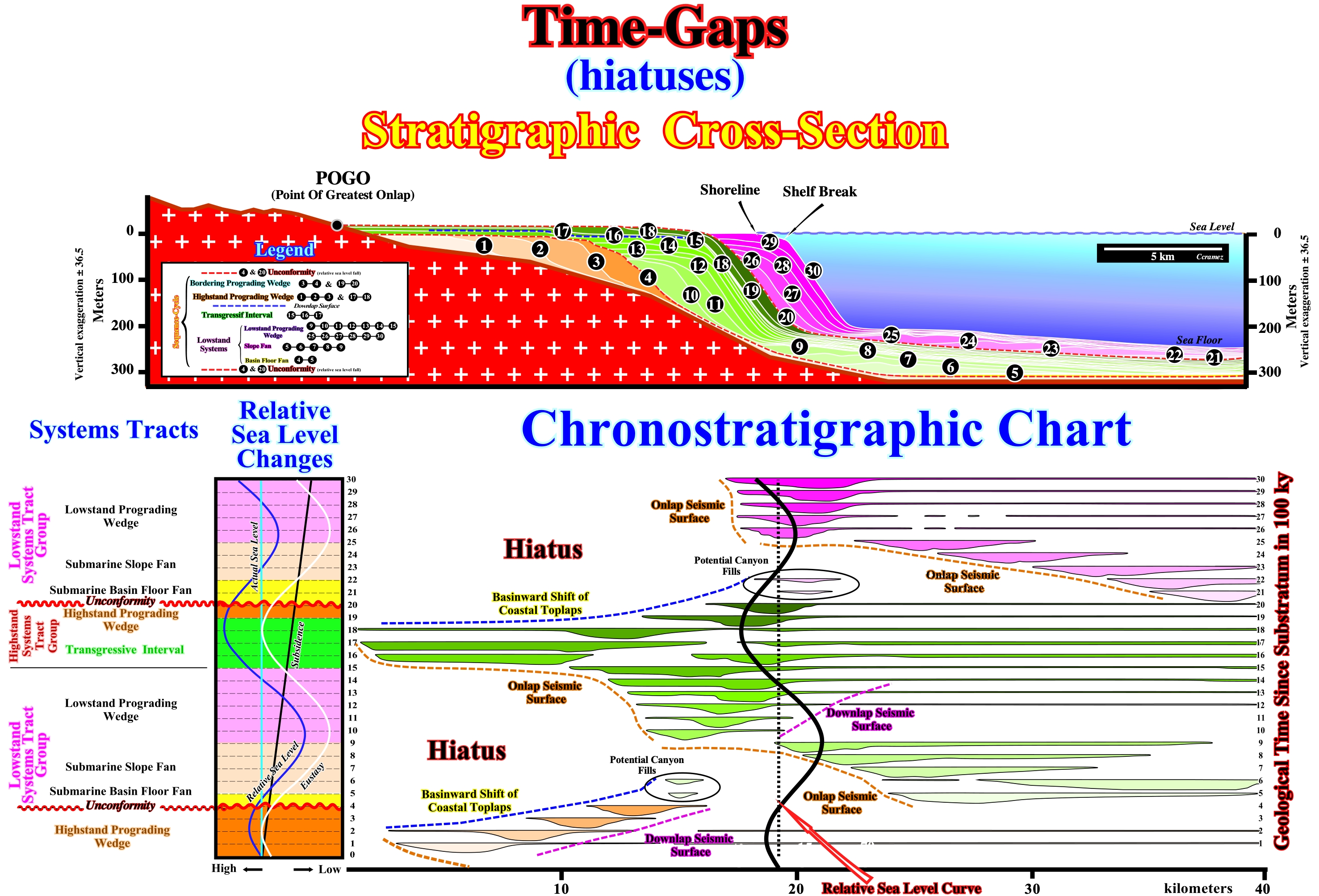
Figure 059- The time -hiatus are clearly recognized on the chronostratigraphic chart of the stratigraphic cross-section between the line of the basinward shift of the coastal onlaps and the onlaps seismic surfaces. The onlap seismic surfaces are characterized by landward, progressively, younger onlaps, i.e., they have retrogradation geometry. The line of the basinward shift of the coastal onlaps dips toward the continent since seaward the coastal toplaps are progressively younger. The same is true for the downlap seismic surfaces because the age of the downlaps increases seaward. The unconformities are also, easily. recognized not only by the onlap seismic surface, but by the end of the basinward shift of the coastal toplaps. The location of the potential canyon-fills plays in the same sense. The age of an unconformity, between two consecutive sequence-cycles, is given by the minimum hiatus between them, which occurs in the deepest part of the basin, i.e., the age of an unconformity is given by the age of the correlative deep-water paraconformity and not by the unconformity itself, since the hiatus along an unconformity (erosional surface) increases landward. Consequently, the micropaleontologic results of an exploration well, crossing an unconformity by the stacking of the transgressive interval (TI) of the upper sequence-cycle over an highstand prograding wedge (HPW) of the lower sequence-cycle, cannot give a correct age of the unconformity.
b.4) The stratal surfaces represent, at least, a common small time unit to the surface in all its length.
b.5) The concept of stratal surfaces is, completely, dependent on the time scale and on considered rock.
c) Geometrical Relationships
The geometrical relationships between seismic reflectors and seismic surfaces defined, by reflections terminations, have a geological meaning just in its original depositional position. Three major geometrical relationships between stratal surfaces or associated seismic reflections, can be recognized : (i) Onlap ; (ii) Toplap and (iii) Downlap.
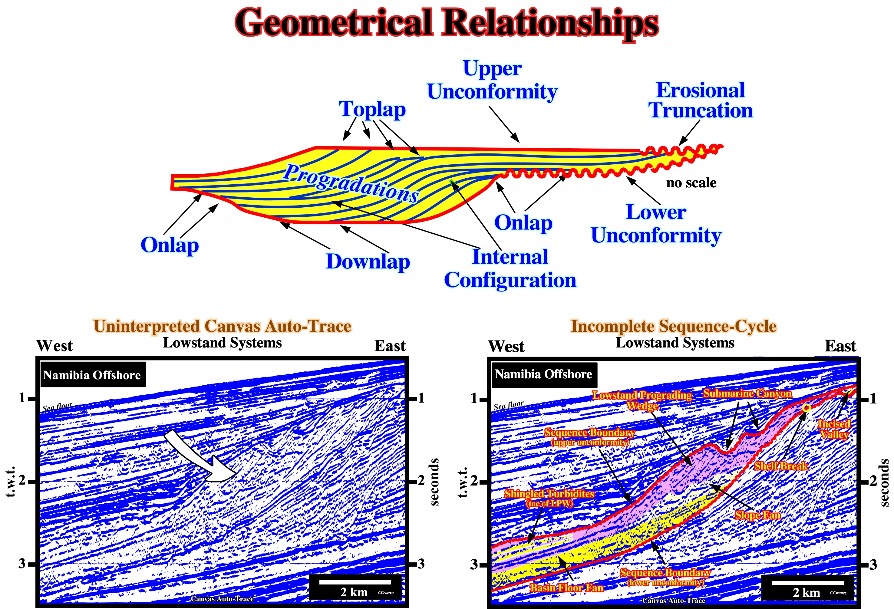
Figure 060- On this preliminry tentative interpretation of a Canvas auto-trace of a Namibia offshore seismic line detail, an incomplete sequence-cycle is, easily, recognized. It is bounded by two unconformities (in red on the tentative interpretation). The age difference between the uncpnformities ranges between 0.5 and 3-5 My. These unconformites are easily identified by onlap seismic surfaces defined by reflection terminations of the different systems tracts deposited above them. In the considered incomplete sequence-cycle, just the systems tracts of the lowstand systems tracts group (LSTG) were deposited. The highstand prograding wedge (LPW) and the transgressive interval (TI) of the highstand systems tracts group (HSTG) are absent. All geoemetrical relationships depicted above can be recognized on this Canvas auto-trace. Taking into account the slight westward tilting of the margin, induced by the regional subsidence, it can be said the geometrical relationships are, more or less, in their depositional position.
Onlap can be :
a) Proximal, when it corresponds to a landward onlap ;
b) Coastal, when it concerns coastal plain sediments ;
c) Marine, when it concerns marine sediments and
d) Mechanical, when it is induced by tectonics (e.g.: faulting).Sedimentary onlapping is characterized by:
1) Aggradation, which corresponds to the vertical component between two consecutive onlaps and
2) Encroachment, which corresponds to the horizontal component between two consecutive onlap.
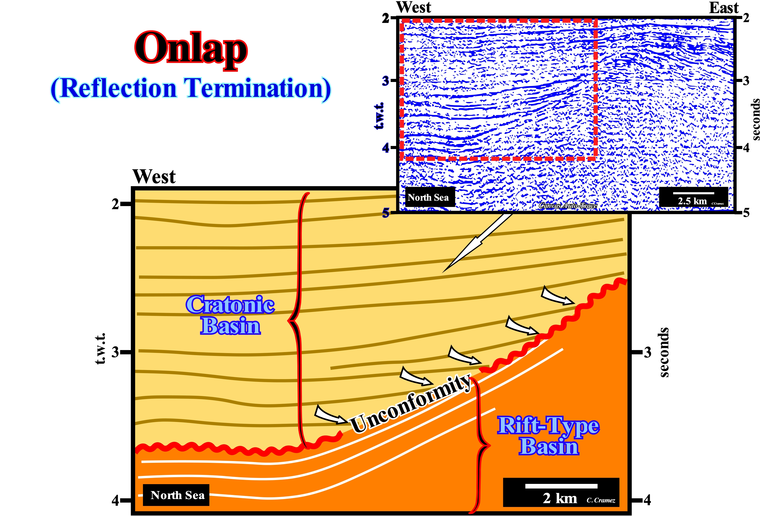
Figure 061- On this tentative geological interpretation of a Canvas auto-trace of a North Sea seismic line detail, it is easy to see the sediments of the cratonic basin (geographic North Sea basin) rest on the sediments of a rift-type basin by onlapping (marine onlaps). From the geological point of view, the infrastructure of the North Sea is formed by the stacking of three basins of the Bally and Snelson (1980) basins classification. From bottom to top, geoscientists recognize: (i) A Paleozoic Folded Belt (not visible on the seismic line of this tentative interpretation), which can be considered as a petroleum basement (absence of source-rocks and significant reservoir-rocks) ; (ii) Several Mesozoic Rift-Type Basins and (iii) A Cenozoic Cratonic Basin. The basal sediments of the rift-type basins are non-marine, but the upper sediments suggest marine ingressions (or a lacustrine sedimentation). That means they were, probably, deposited during stability periods of relative sea level, which occur after each relative sea level rise in acceleration (eustatic paracycle). These eustatic paracycles form a set of sequence-paracycles (sedimentary regressions). The unconformity (erosional surface underlined by the red wavy line) between the sediments of the rift-type basins and the cratonic sediments is very noticeable due to the marine onlaps of the sediments of the cratonic basin. This unconformity was, locally, tectonically enhanced (uplifting probably induced by a sedimentary shortening). Locally and especially at the top of the buried-hill of sediments of the rift-type basin, it can be considered as an angular unconformity. However, even when tectonically enhanced, the erosional surface is, mainly, induced by eustasy (changes in absolute sea level, which is supposed to be global and referenced to the Earth's center) and not by tectonics. To have erosion (degradation produced on the terrestrial surface by destructive agents or erosive agents such as rivers, torrents, seas, winds, glaciers, etc.), the sediments must be exposed to the erosive agents. So, a significant fall of the relative sea level (combined action of absolute sea level and tectonics) is indispensable. The simple uplift of the rocks, either by a compressive tectonic regime (shortening of sediments as in an anticline structure), or by an extensive tectonic regime (lengthening of the sediments, such as that created in the overburden of a salt-dome or as in turtle-back structure) is not enough. Sediments must be exposed in surface or at bottom sea to be eroded. On this tentative interpretation the continental encroachment and aggradation of the intervals overlapping the unconformity can be, easily, calculated in time and depth (if the velocity with which the seismic waves pass through the cratonic sediments is known). They underline the morphology of the unconformity which, as stated above, was locally tectonically enhanced (probably following an arrangement of lithospheric plates). As shown on upper right part of the auto-trace, the sediments underlying the unconformity (rift-type sediments) are, clearly, truncated under the top of the paleo-high, while at the west end of the auto-trace they are perfectly concordant with the overlying sediments. The interface between the cratonic and the rift-type basin sediments at the top of the paleo-high corresponds to a tectonically enhanced unconformity (angular unconformity of certain geoscientists), while at the west end of the auto-trace, it corresponds to a paraconformity, since there is no attitude difference between the overlying and underlying strata, but just an hiatus by non-deposition between them.
Toplap is a termination of strata against an overlying surface. Toplaps occur along the upper interval boundary. The term toplap is used when it results of non-depositional process (sedimentary bypass) with only minor erosion. Downdip of a toplap there is always a downlap or an apparent downlap. Toplap is mainly associated with coastal deposits (coastal toplaps). When a toplap is induced by erosion it is called truncation. Truncation corresponds to a termination of strata or seismic reflection, interpreted as strata, along an unconformity surface due to post-depositional erosional. Truncation, as toplapping, occurs along the upper interval boundary. Truncation implies deposition of strata and their subsequent removal to form an erosional surface (unconformity).

Figure 062- In the lower photographs, the scale is given by a geoscientist, who are close to the toplap (within the ellipse) of sandy bodies of fusiform geometry. It is evident this type of lapout* s not associated with a significant erosional surface, but rather with a non-depositional surface. They does not, necessarily, stress an unconformity. In general, this means it does not correspond to a stratigraphic cycle boundary. In strata or groups of successive dipping beds deposited on each other progradationally basinward (lateral accretion or outbuilding), the lower terminations are downlaps. The shape of each sedimentary body is fusiform. Its thickness increases to a maximum, then thins until disappearing by pinchout. The upper and lower progradational lapouts underline converging intervals, upstream and downstream. On any tentative geological interpretation, whether it be on a seismic line or an outcrop, i.e., an exposure of the top of a rock or rock interval, close to the surface of the ground and directly observable, always requires a scale. Geology is a dependent scale. On these photographs, if the geoscientists were not present to give the scale, an observer would recognize a progradational geometry but he would be unable to interpret it in environmental terms. The scale problem is complicated in the geological interpretation of seismic data. A seismic line, without horizontal scale (metric) and vertical (double time), can not be, correctly, interpreted in geological terms. Within a sequence-cycle, the progradations associated to a delta interval, developed in a lowstand prograding wedge (LPW) have the same geometry as the progradations of a continental slope or of an oblique stratification within a bed in the highstand systems tracts group (transgressive interval, TI and highstand prograding wedge, LPW). The horizontal and vertical scales are, completely, different. In a delta, the vertical scale is on the order of tens of meters (the height of a delta slope exceeds, rarely, 30-40 meters). In a continental slope, the vertical scale is of the order of hundreds or thousands of meters and in a bed it is centimetric or metric. Without the scales, a georadar line (used in geotechnics engineering) can be taken as a 2D seismic line used in petroleum exploration. An oblique stratification can be taken as a continental slope. The vertical scale of the first is in nanoseconds (10-9 s), while the vertical scale of the second is in seconds (double time, t.w.t.). If you have questions about this, make a test. Ask a colleague what is the average thickness of a delta. The answer to such a question will be, probably, a few hundred or thousands of meters. If this is the case, your colleague confuses a prodelta (seaward dipping beds of a delta) with a continental slope. The average thickness of a delta is 30/50 meters. However, the thickness of a delta building, such as the Mississippi delta building, which is the stacking of several hundred deltas, exceeds, easily, thousands of meters. On the Canvas auto-trace of an Uruguay offshore seismic line illustrated in this figure, toplaps are obvious (some of them are emphasized by the yellow arrows). Taking into account the vertical scale of the auto-trace, the progradations should be interpreted as continental slopes and not as delta progradations. On the other hand, their geometry must be corrected (even if by simple mental experience) of the pitfall induced by the increasing water-depth of the present-time continental slope, because the velocity of the seismic waves is smaller when they cross water than when they cross sediments. The seismic reflectors underlying the present continental slope should be, significantly, raised. The downlap of the different progradational sedimentary packages is, in depth and at natural scale (1: 1), much less inclined than the one suggested by the auto-trace. Sometimes, the more distal and deeper reflectors underlying a large water-depth may even have a slope contrary to that suggested by the auto-trace of the time seismic line.
* Lateral termination of a stratum or a seismic reflector within the limits of its deposition, in general, against an unconformity (erosional surface). There are two types of termination: (i) Basal Termination occurring at the lower limit of either the sequence-cycle or a sequence-paracycle and (ii) Top Termination occurring at the upper limit. A basal termination may be aggradational (onlap) or progradational (downlap). A top termination can be by truncation (erosional) or by non-deposition. Synonym with Onlapping.
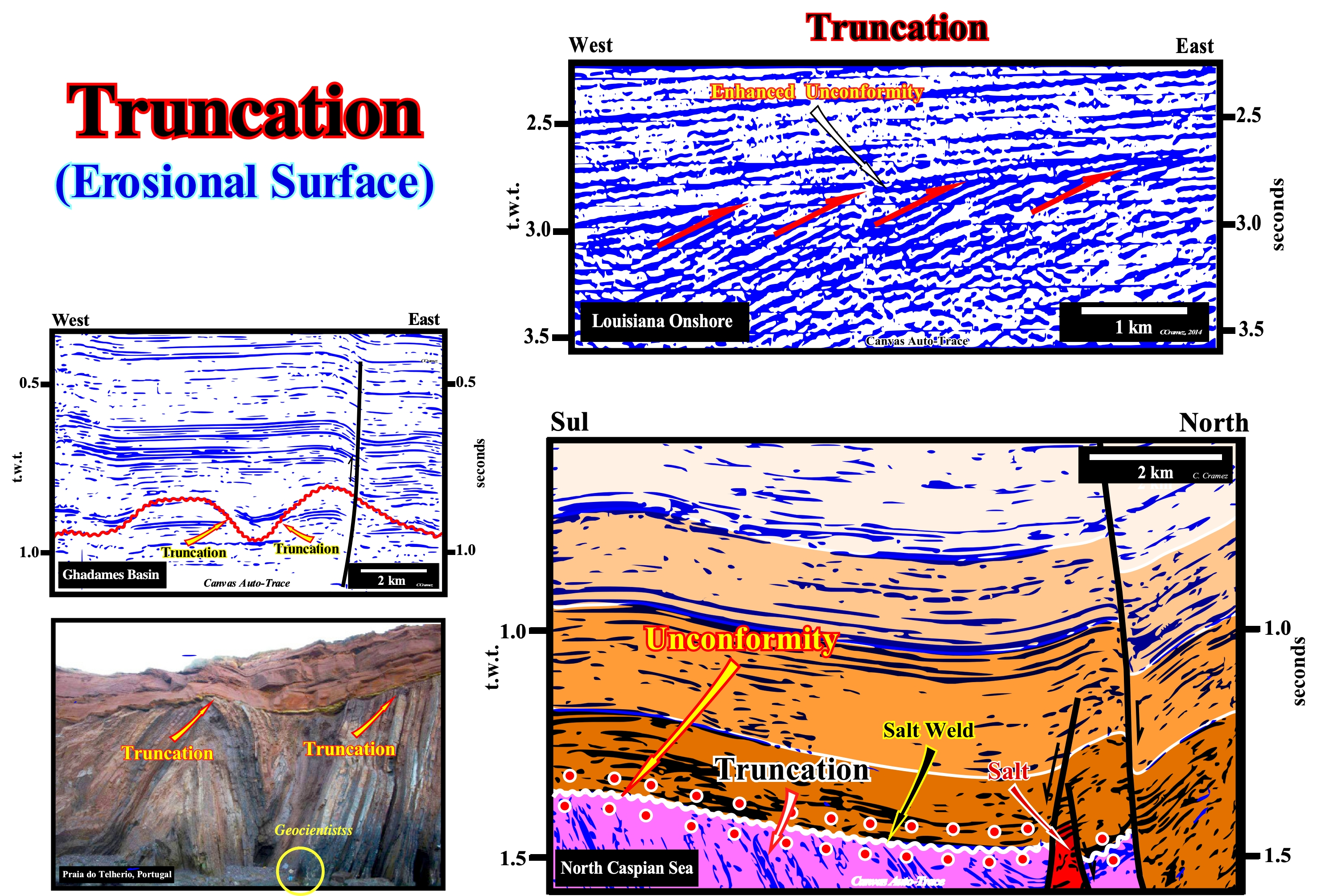
Figure 063- On the Canvas auto-trace of the seismic line from onshore Louisiana (USA), two large seismic interval are, readily, recognized. The upper one is composed by reflectors, more or less, parallel and slightly dipping westward. The lower one is also composed by parallel reflectors (between themselves), but dipping westward much more than the formers. The strata associated with the lower interval were tilted and then truncated by erosive agents, which led to a tectonically enhanced unconformity. However one should not forget that the erosion occurred due to a relative fall in sea level (eustasy plus subsidence or uplift of the sea floor) which exhumed the sediments and not just due to tectonics. That means the tectonic (uplift or subsidence) without exhumation (relative sea level fall) does not create any unconformity (erosional surface). The time interval between these two sedimentary intervals correspond to an erosional hiatus and not to a hiatus by non-deposition. On the tentative geological interpretation of a Canvas auto-trace of a northern Caspian Sea seismic line (detail), the terminations of the reflectors underlying the unconformity (white wavy line) are toplaps by truncation, i.e., part of the sediments underlying the unconformity was eroded after the sediments had been deformed. In sequential stratigraphy, an unconformity is an erosional surface induced by a relative sea level fall, which put the sea level lower than the basin edge (continental edge when the basin has a shelf). In certain cases, the basin edge is, more or less, coincident with the shoreline (during the 2nd stage of development of the highstand prograding wedge of a sequence-cycle). Unconformities are, mainly, induced by eustasy (absolute sea level changes) and not by tectonics. The sediments have to be exhumed to undergo the action of erosive agents (gravity, rain, wind , ice, rivers, etc.). However, unconformities may be tectonically enhanced and create, what certain geoscientists call angular unconformities. A shortening or a lengthening of sediments can not produce an unconformity (erosional surface) if the sediments are not exhumed. Just when there is a significant and regional erosion, i.e., when the sediments are exhumed, an unconformity is developed. Such a conjecture is not falsified in salt basins (North Caspian Sea auto-trace), where the lateral or vertical salt flowage deform (lengthen) the overburden without creating an unconformity, i.e., without the overlying sediments being eroded. Between the infra and supra-salt sediments a tectonic disharmony (not to be confused with an unconformity) is formed. The tectonic disharmony reaches its paroxysm when the salt layer is, totally, evacuated forming a salt weld (surface that puts in contact strata originally separated by an autochthonous or allochthonous evaporitic level), which corresponds to a negative structure resulting from the partial or total outflow or expulsion of the salt horizon. In the field or in well cores, a salt weld is, mostly, recognized by an insoluble, more or less, brecciated residue with halite pseudomorphs. Such a residue is too thin to be visible on seismic data, in which it is underlined by a tectonic disharmony. One of the characteristics of a salt welding is presence of tectonic inversions in the salt overburden. On the tentative geological interpretation of the North Caspian Sea Canvas auto-trace, it is evident that the unconformity underlined by the white wavy line, which in this particular case coincides with a salt weld was tectonically enhanced (lengthening, followed by a shortening). The area where the seismic line was shot belongs to a sedimentary basin characterized, at the geological point of view, by the presence of a thick Permian saliferous interval (Hungarian, 258/263 Ma) that induced an important salt tectonic. At petroleum exploration point of view, this area is well known due to the recent (2000) discovery of a giant field (Kasaghan), whose reserves (recoverable) seem to be quite important, which is, probably, sufficient to counterbalance the high SH2 content and climate conditions the area. The lateral and vertical flow of salt, deposited on the Artinskian (263 / 268 Ma) shaly source-rocks, deformed and raised (extension, lengthening) the Triassic sediments, which were. partially, eroded before being covered by Jurassic marine sediments. Later, the whole set was shortened (compressed) by a regional compressional tectonic regime associated with the closure of the Tethys Sea (former sea between the NE of the Gondwana small supercontinent and SE of the Laurasia small supercontinent , which replaced the Paleo-Tethys ocean, since the expansion of the Tethys Sea forced the Cimmerian plate to collide with the Laurasia, to, finally, the Tethys Sea replace, completely, the Paleo-Tethys.
Downlap is a base discordant relation in which initially inclined strata terminated downdip against an, initially, horizontal or inclined surface. A downlap geometrical relationship indicates the direction away from the source of terrigeneous influx. A seismic downlap is a downlap interpreted on a seismic section, i.e., a relation in which a seismic reflection, interpreted as initially inclined strata, terminates downdip against a reflection discontinuity interpreted as an initially inclined or horizontal sedimentary discontinuity, which can be : (i) A flooding surface ; (ii) A complex transgressive backstepping surface ; (iii) An unconformity or (iv) A paraconformity (conformity with an important hiatus).
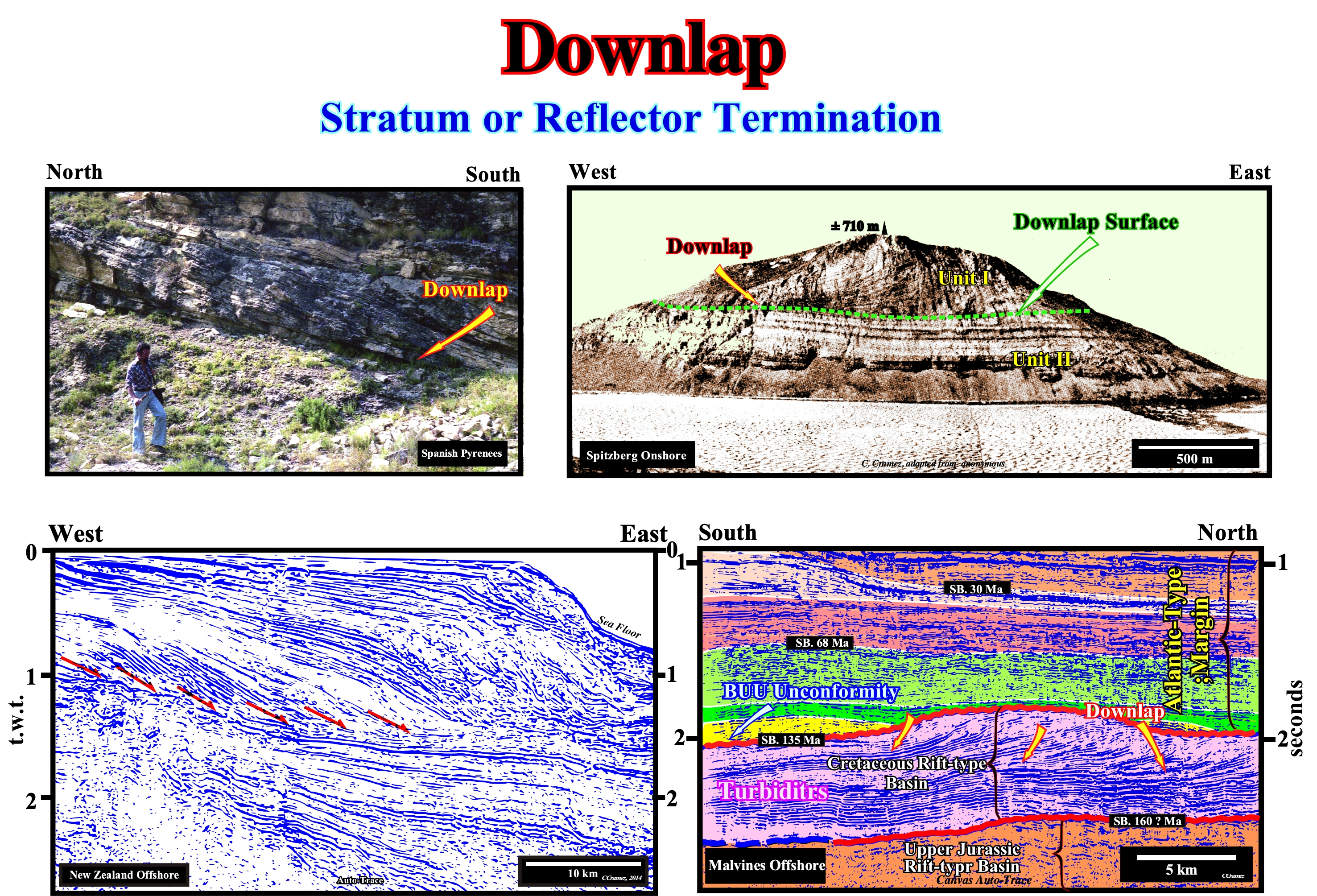
Figure 064- The mountain visible in the photograph (Spitzberg, Bears Island) is constituted by two stratigraphic units. The lower (Unit II) of carbonate facies has a retrogradational geometry, i.e., that the different intervals that compose it thicken slightly continentward (at the time of deposition), That is to say, westward. Apparently, this corresponds to a global continentward shift of the depositional coastal break of the depositional surface which coincides, more or less, with the shoreline. This retrogradational unit consists of small regressive sedimentary intervals that overlap one another, but which, overall, create a retrogradational geometry. Each of these small regressive sedimentary intervals corresponds to a sequence-paracycle, which was deposited following a marine ingression. The space available for the sediments (accommodation), created by the relative sea level rise, which displaced the shoreline continentward, was, during the stability period of relative sea level occurring after each marine ingression, partially or totally, filled by the sediments. Such a deposition, progressively, displace, once again, the shoreline seaward, creating what the geoscientists call a sedimentary regression. This sequence of geological events can be summarized as follows: (i) A marine ingression, induced by relative sea level rise, creates the space required for deposition ; (ii) A period of stability of the relative sea level occurs after each marine ingression and deposition resumes creating a sedimentary regression as the shoreline moves seaward ; (iii) New marine ingression, but more important than the previous one ; (iv) New sedimentary regression, but less important than previous one ; (v) New marine ingression, etc., etc.. Each relative sea level rise, i.e., each marine ingression causes a continental flood and the formation of a ravinement surface. The continentward displacement of the depositional coastal break of the depositional surface (more or less the shoreline) creates or increases the shelf extension, which, in general, decreases the terrigeneous influx (at least in relation to the extension of the platform continental). During the period of stability of relative sea-level stability following each of the eustatic paracycles, the shoreline, gradually, moves seaward as the sedimentary particles deposit by progradations (sedimentary regression). During successive regressions, the shoreline does not reach the old position that it had before the preceding relative sea level rise. It is the set of increasingly important marine ingressions and increasingly smaller sedimentary regressions (retrogradational geometry) that C. Emiliani called transgressions (not transgression, as many say). Since the relative sea level rise is smaller than the previous one (relative sea level rise in deceleration), during the stability period of the relative sea level, the shoreline moves seaward and goes beyond the old position, which it had at the end of the preceding sequence-paracycle. It is the beginning of the regressive unit (Unit I, in this photograph). This regressive interval corresponds to a succession of increasing regressions, induced by smaller and smaller marine ingression, which are responsible for the creation of available space for sediments. It is, more or less, the opposite of what happened during the deposition of Unit I, in which marine ingressions became increasingly important and sedimentary regressions became smaller and smaller. In this way, the sedimentary systems tracts deposited in association with the relative increases of decelerating sea level, progressively, fossilize the old continental platform by downlapping. This fossilization creates a downlap surface, which is clearly visible in this photograph, and which is by no means an unconformity. It does not correspond to an erosional surface, but to a surface characterized by having a deposition rate very small or even nonexistent. It corresponds to a surface along which the hiatus by non-deposition increases regularly seaward. When there is amalgamation of the distal deposits of a regressive interval, as illustrated in the tentative geological interpretation of a Canvas auto-trace of a seismic line from Malvinas offshore, one can not speak of the downlap surface but of a diachronic surface of the base of the continental slopes, which in this particular case, appear to be a stacking of delta slopes. In the photograph taken in the Spanish Pyrenees, the downlaps emphasize the progressive displacement of the sands of a point bar (meander) towards the central part of the bed of a river current. On the Canvas auto-trace of the New Zealand offshore seismic line, some oblique reflectors end, downdip, by downlaps and others, probably, by apparent downlaps (induced by seismic resolution). These geometric relationships indicate the direction of the sea and subsequently the direction of sediment transportation. On this example, these geometrical relationships are associated with the base of the continental slope progradations, since the amplitude of the oblique reflectors exclude delta slopes prograding in a continental platform. Downdip, the discontinuities are unconformities or their correlative conformities (limits of stratigraphic cycles).
There are two kind of apparent downlaps :
(i) Those created by tectonics (particularly by halokinesis and shalokinesis), which correspond, very often, to tilted onlaps due the salt or shale flowage and
(ii) Those induced by seismic resolution, i.e., seismic reflections, representing units of inclined or tangential strata, can terminate downdip, but the strata themselves, actually, flatten and continue as units, which are so thin that they fall below the seismic resolution.d) Stratigraphic Boundaries
A stratigraphic surface can be considered as a continuous physic limit. Three major groups of stratigraphic surfaces can be observed in the field or in seismic data : (a) Stratal Surfaces ; (b) Discontinuity surfaces and (c) Diachronic surfaces
d.1) Stratal surfaces
The bedding planes and the chronostratigraphic seismic reflectors are stratal surfaces. A seismic reflector represents sedimentary interval, more or less, thick. The thickness of the interval depends of the seismic resolution, which can range between 10 and 100 meters.
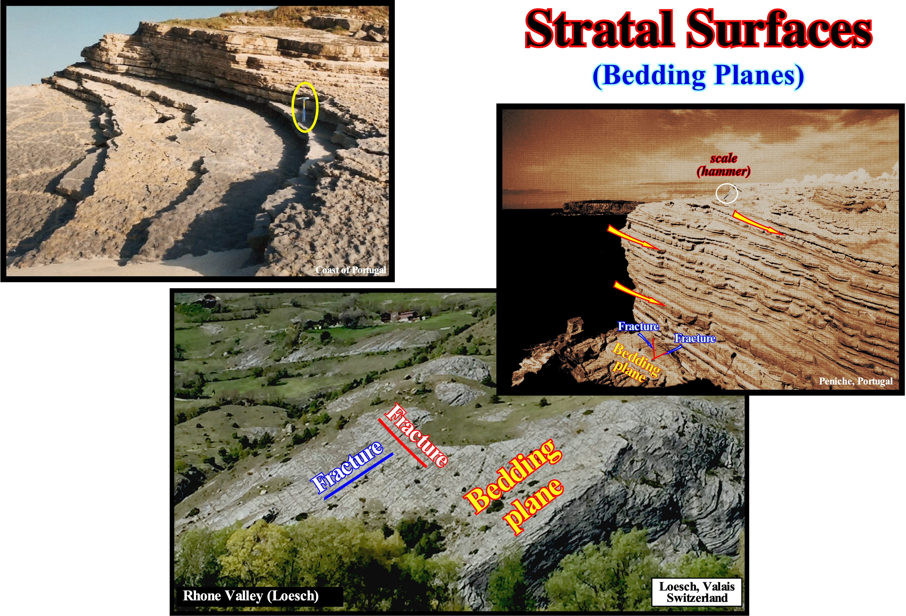
Figure 065- As illustrated in these photographs, sedimentary beds and bedding planes are obvious in the cliffs forming part of the coast of Portugal, as well as in the hillsides of the Rhone valley, particularly, eastward of the city of Sion in the Loesch area. Sedimentary particles, whether they are clastic or precipitate, are deposited, almost always, in more or less parallel levels called beds or strata. When the thickness of the layers is of the order of centimeters, geoscientists call it a bed. When the layers are very thick, certain geoscientists call them banks. The stratification results from the tendency that water and wind have to spread, over great distances, similar layered sediments, relatively, thin for periods of time with, relatively, analogous environmental conditions. When environmental conditions change at the deposition site, several things can happen: (i) Different sediments may settle down on the top of the previous bed ; (ii) There may be a period during which no sediment is deposited ; (iii) The original bed can be eroded. In all these cases, due to the common depositional environment, the sediments tend to be much more similar within beds than between them. Although sediments tend to be more similar within a bed than between them, lateral continuity has finite boundaries. A particular bed can be thin and pinchout laterally without leaving any record of the deposition time in the area of pinchout. The type of sediment that characterizes a certain level may, laterally, shift to another type within the same bed, which suggests the deposition environment has changed gradually. Certain combinations of depositional environments promote abrupt discontinuities of similar sedimentary horizons. The sands and clay rocks deposited by a river are, sometimes, very discontinuous due to repeated channeling and flooding. Other sedimentary environments induce more continuous beds such as pelagic clayey rocks, in the deepest parts of the basins, i.e., at the base of the continental slope or the abyssal plain. The stratification surfaces represent a relatively small gap. If the gap is larger, the surface corresponds to a unconformity (erosional surface induced by a relative sea level fall that put the sea level below the basin edge). All unconformities have a minimal gap anywhere. The minimum gap is at the base of the continental slope. It is this minimum gap (underlined by the deposit of the submarine basin floor fans) that gives the age of unconformity between two stratigraphic cycles. As illustrated in these photographs, fracture systems, sometimes orthogonal, are visible, often, on the bedding planes. On this subject it is interesting to note that in the sixteenth century, Niels Steensen (1669) recognized that sedimentary rocks were: (i) Formed of beds or strata ; (ii) Overlapping each other in the order they have accumulated ; (iii) More or less horizontal at the moment of deposition ; (iv) In lateral continuity until pinchout at the edge of the depositional basin. Steno, known in the Court of Medicis as Niels Steensen, advanced these conjectures in the book "De solido intra solidum naturaliter contento dissertationis prodromus". He used the bedding to map and interpret the sedimentary rocks. As a result, Jean-Etienne Guettard used the beds, as did Georges Cuvier, in his map of France, and William Smith (1815) when he mapped the sedimentary strata of England on the basis of lithology, erosive ruptures, and sequencing of the fossil content of the beds. Undoubtedly, the recognition of the beds must have had an older origin. As early as the fifth century BC the contemporaries of Pythagoras were aware of the layered accumulation of the sediments found in the exposed portions of the Earth's crust (Lyell, 1830). McKee and Weir (1953) defined a bed as a three-dimensional rock body, which can be mapped, laterally, of physical, chemical, mineralogical and biological composition, relatively, uniform and distinguishable from the rock above and below it. These geoscientists also consider that a 1 cm thick bed is very thin and that a 1 m bed is considered to be very thick, whatever, in seismic lines, only groups of beds may eventually become evident.
d.2) Discontinuity Surfaces
Discontinuity surfaces are physical surfaces caused by erosion or by non-deposition. The discontinuity surfaces included : (1) Unconformities ; (2) Paraconformities and (3) Deposition hiatuses. Unconformities, caused by erosion (relative sea level fall that puts the sea level lower than the basin edge).
d.2.1)- Unconformities are discontinuous stratigraphic surfaces. Dunbar and Rodgers (1957 defined an unconformity as a temporal break in a stratigraphic sequence resulting from a change in regimen that caused deposition to cease for a considerable span of time., implying, normally, uplift and erosion with the loss of some of the previously formed record.
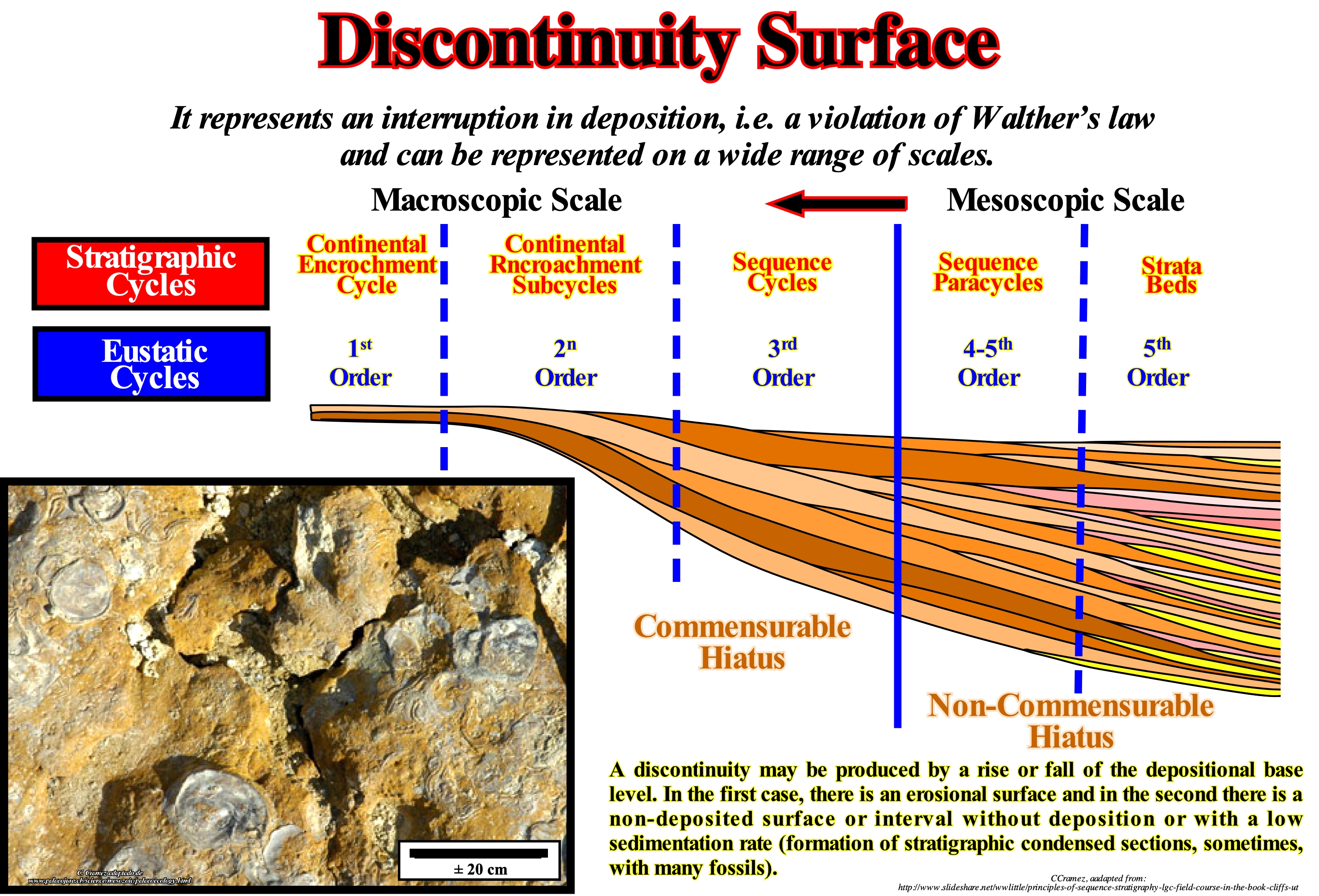
Figure 066- Conventionally, the discontinuity surfaces with little or no associated erosion can not be limits of the stratigraphic cycles. This is particularly true for the stratigraphic cycles referred to as the sequence-cycle (induced by 3rd order eustatic cycles having a duration between 0.5 My and 3/5 My). They can not be considered as unconformity. They are not induced by a significant relative sea level fall, which put the sea level lower than the basin edge (limit downstream of the continental shelf when the basin has a platform). When the basin, at the level of a sequence-cycle, does not have a continental shelf, the continental edge is the last basin edge of the preceding sequence-cycle. Under highstand geological conditions, if the basin has no platform (2nd stage of development of the highstand prograding wedge), the basin edge of the basin is the continental edge (upper limit of the continental slope). Discontinuity surfaces are, generally, contemporaneous with sedimentation, as those formed between the transgressive interval (TI) and the highstand prograding wedge (HPW) of a sequence-cycle. They may also postdate deposition, as the tectonic disharmonies induced by lateral or vertical flow of a mobile intervals (salt and certain shale layers). From the sedimentary point of view, the most interesting discontinuity surfaces are the contemporaneous of the sedimentation. They characterize a hiatus (gap) by no significant deposition or a condensed stratigraphic section, which translates to a very small sedimentation rate. Generally, all discontinuity surface, such as hardground surfaces or bedding planes with fossils (dinosaur remains, for instance) or desiccation fractures are omission surfaces, as shown in this figure. That is why marine potential source-rocks, i.e., marine rocks rich in organic matter, are almost always associated with surfaces of this type. In carbonated platforms, such surfaces mark the transition between shallow water to deep water lithologies. They reflect reactions of the sedimentary system to the rapid and drastic environmental changes and record the most important time intervals of the evolution of the platforms. In shallow carbonate platforms, the sedimentary record represents only a small part of the geological time. Many of the sedimentary intervals have not been deposited or are just in the form of reworked intervals. All this means that it is very difficult to estimate the time interval associated with a discontinuity or omission surface. It can range from a few days to millions of years. These discontinuity surfaces are relative to layers of different rocks and have nothing to do with the discontinuities found inside the Earth. For many geoscientists a discontinuity designates a transition or contact between intervals at different densities, such as Mohorovi?i? discontinuity, or with different sedimentary facies (lithologies), or between intervals separated by a hiatus (absence of significant deposition). In geology there are several types of discontinuities: 1- Stratigraphic ; 2- Sedimentary ; 3-Lithological ; 4 - Tectonics, etc.. Among the lithological discontinuities, which are the most important in sequential stratigraphy, we can recognize: (i) Concordant Discontinuities, when there is continuity between successive intervals ; (ii) Paraconform Discontinuities or Paraconformities, when there is no difference in attitude between overlapping intervals, but there is a hiatus due to the absence of significant deposition between them ; (iii) Non-Conform Discontinuities or Non-conformities (which certain authors call Heterolytic Discontinuities), when there is a contact between a sedimentary interval and an older igneous body ; (iv) Discontinuous Discontinuities or Disconformities, when the layers of the intervals are parallel on either side of the contact surface which does not conform to the regional stratification ; (v) Discordant Discontinuities or Unconformities when the two intervals are separated by an erosional surface induced by a relative sea level fall ; (vi) Enhanced Discordant Discontinuities or Tectonically Enhanced Unconformity, when the sediments of the interval underlying an unconformity discordance were deformed by tectonics (shortened or lengthened) ; (vii) Intrusive Discontinuities, when an igneous body traverses a sedimentary series; (viii) Mechanical Discontinuities, when they are induced faulting, etc. (https: // estpal13. wordpress.com/2013/06/04/ descontinuidades-sedimentares-e-estratigraficas/).
Type I and II unconformities, as well as, their correlative deep-water paraconformities, which are the limits of the stratigraphic-cycles. Type I unconformities are associated with significant relative sea level falls, which put the sea level lower than the basin edge. Type II unconformities are associated with small relative sea level falls, which, normally, do not exhume the shelf or just part of it. A Type I unconformity correlates, seaward, i.e., in the abyssal plain, with the base of the submarine basin floor fans (SBFF), which is not the case of type II unconformities. Downlap surfaces, which are not unconformities, may limit a stratigraphic cycle in the distal part of the abyssal plain when the progradations of the highstand prograding wedge (PNA) lie, directly, on sediments of an underlying stratigraphic cycle by downlaps.
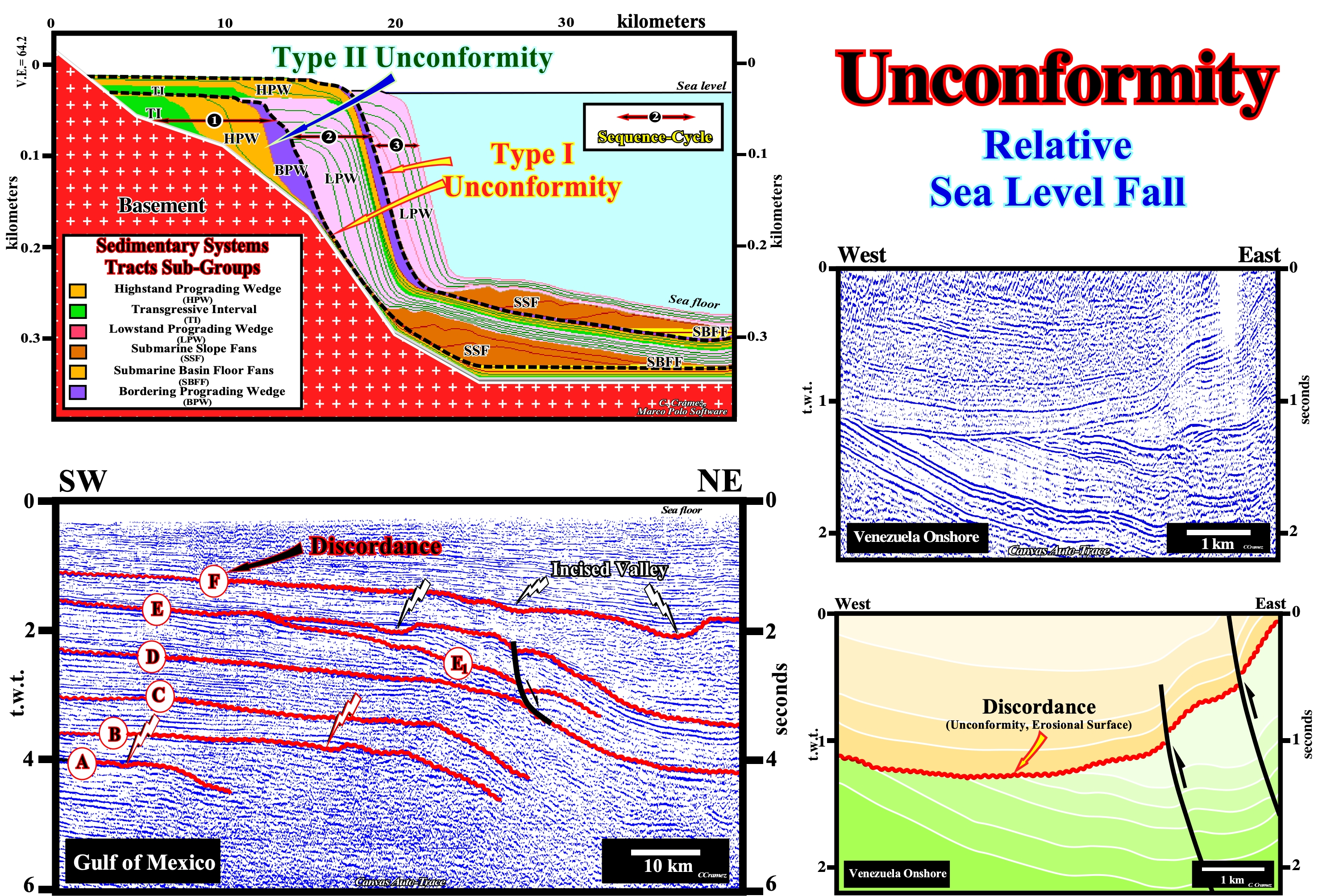
Figure 067- In this mathematical model (Marco Polo Software) are illustrated three stratigraphic cycles called sequence-cycles induced by 3rd order eustatic cycles, i.e., by eustatic cycles with a time-duration ranging between 0.5 and 3-5 My. All stratigraphic cycles are limited by unconformities. They underline, more or less, cryptic erosional surfaces created by relative sea level falls, which are the result of the combination of absolute sea level (supposed global and referenced to the Earth's center) and tectonics (subsidence of the sea floor, when the predominant tectonic regime is extensional or uplift when it is compressional). Locally, a, more or less, cryptic unconformity can be tectonically enhanced, creating what some geoscientists call an angular unconformity. Relative sea level fall (local sea level and referenced either to the sea floor or to the top of the continental crust, have to be, sufficiently, important to put the sea level to lower than the basin edge, which creates a Type I unconformity (erosional surface). Following a significant relative sea level fall, highstand geological conditions change to lowstand geological conditions. When the relative sea level is not lower than the basin edge, the associated unconformity is a Type II unconformity and it is not a stratigraphic cycle limit, since the deposited interval (bordering prograding wedge, BPW) is an integral part of the sequence-cycle. In this scheme, only the intermediate sequence-cycle (sequence-cycle 2) is complete. From the base to the top, and above a Type I unconformity, the following systems tracts subgroups are identified: (i) Submarine basin floor fans (SBFF) ; (ii) Submarine slope fans (SSF), ; (iii) Lowstand prograding wedge (LPW) ; (iv) Transgressive interval (TI), (v) Highstand prograding wedge (HPW) and (vi) Bordering prograding wedge (BPW). The first three subgroups, i.e., the submarine basin floor fans (SBFF), submarine slope fans (SSF) and lowstand prograding wedge (LPW) form the lowstand systems tracts group (LSTG). The transgressive interval (TI), highstand prograding wedge (HPW) and bordering prograding wedge (BPW) form the highstand systems tracts group (HSTG). As it can be seen in this sketch, the submarine basin floor fans (SBFF) have a geometry, more or less, parallel and aggradational. The submarine slope fans (SSF) have a wavy geometry (gull-wings structures of P. Vail). The lowstand prograding wedge (LPW) has a progradational geometry. The transgressive interval (TI) has a retrogradational parallel geometry, whereas the highstand prograding wedge (HPW) and the bordering prograding wedge (BPW) have progradational geometries, but the aggradation is less marked in the highstand prograding wedge than in the bordering prograding wedge. Within a sequence-cycle, the highstand prograding wedge (HPW) is separated from the transgressive intervals (TI) by a downlap surface, which means that the boundary between these two subgroups of sedimentary systems tracts is diachronic. Sequence-cycle 1 is incomplete and formed just by highstand systems tracts group (HSTG), in which the transgressive interval (IT), the highstand prograding wedge (HPW) and the bordering prograding wedge (BPW), which is separated from the highstand prograding wedge by a Type II unconformity. The sequence-cycle 3 is, also, incomplete and composed just by the lowstand systems tracts group (LSTG), i.e., by the submarine basin floor fans (SBFF), submarine slope fans (SSF) and lowstand prograding wedge (LPW), whose progradations, generally, fossilize the submarine fans. increases).On this tentative geological interpretation of a Canvas auto-trace of a Maracaibo Lake (Venezuela) seismic line, discordances are, easily, recognized by the terminations of the underlying reflectors, which were truncated (toplaps by truncation). The unconformities were, locally, tectonically enhanced. On the auto-trace of a Gulf of Mexico seismic line, the reflectors overlying the F discordance are, in this area, apparently, parallel to the discordance. However, on seismic lines striking North-South (perpendicular to the line of this tentative interpretation), the lower terminations of the reflectors of the interval overlying the discordance (picking in red) are downlaps, which means that the observed concordance on the West-East auto-traces is apparent. One of the main problems in identification of discordances is to know what is the preponderant factor: (i)i Eustasy (absolute sea level, which is supposed to be global and referenced to the Earth's center) or (ii) Tectonics. It is important to understand that a shortening produces an uplift, that, generally, it does not imply an erosion. The erosion of uplift sediments is just important when they are exposed to erosive agents, i.e. if they reach the surface. A deep salt dome, for instance, uplift the overlying sediments lengthened them by antiform structures. However, if such antiform structures do not reach the surface, there is no associated erosion. To have erosion, the relative sea level must fall in order to expose the sediments at the erosional agents. The sediments must be exhumed. For most geoscientists, the rate of eustatic changes (absolute sea level changes) is greater than the rate of tectonic changes, which means that, basically, all discordances have an eustatic origin although they can be, locally, enhanced by tectonics. For some specialists in structural geology, in certain sedimentary basins, as for instance in foreland basins, the tectonic factor may be preponderant. In the tentative interpretation the discordances on the seismic line of the Gulf of Mexico, it is evident that in their great extent the discordances are cryptic. They are difficult to bring to light from the geometric relations between the different reflectors. What saves the geoscientists in charge of such an interpretation are the fillings of the submarine canyons (in the upper continental slope) and the fillings of incised valleys near and upstream of the basin edges (here coincident with the shoreline). With a significant relative sea level fall, the shoreline and the river mouths are displaced seaward and downwards destroying the provisional equilibrium profile of the water-courses. They are forced to incise their beds to reach a new provisional equilibrium profile creating submarine canyons and valleys incised. These negative bathymetric anomalies induced by the erosion associated with relative sea level falls will be fulfilled after relative sea level rises. The filling of the incised valleys and submarine canyons occurs during the final development of the lowstand prograding wedges level, in association with the marine ingression responsible for the 1st transgressive surface.
The hiatus (time) associated with the unconformities can represent :
(i) A long period of subaerial exposure, with a minimum erosion, locally with incised valleys and fluvial canyons.
(ii) A period of uplift with an important subaerial erosion of the strata ;
(iii) A submarine erosion induced by turbiditic currents, slumpings or submarine currents.A submarine erosion induced by gravity currents (turbiditic currents) is, generally, local. The unconformities associated with such erosion type are local an located, mainly, in deep water environments (continental slope and abyssal plain). These unconformities have no equivalent in shallow water. Subsequently, they are not stratigraphic cycles boundaries, except when the cycles are incomplete, i.e., when the stratigraphic cycles are just formed by deep water sediments. The uplifts ( tectonic shortening induced by compressional tectonic regimes) and erosion are characterized by :
(A) Onlap above the erosional surface (unconformity) and
(B) Truncation below.Often, geoscientists put in evidence unconformities by the associated incised valleys, however they confuse, quite often, the incised valley with the infilling sediments. A valley is a morphology corresponding to a low land place limited, laterally, by highlands. An infilling of a valley are sediments , more or less, consolidated deposited by a transportation agent that totally or partially infilling the valley. A channel is the bed where the water body flows. The infilling of a channel are the sediments deposited in the channel,particularly, when the channel is abandoned or when transport capacity is insufficient to remove the furnished material.
d.2.2) Paraconformities are separated parallel layers with a hiatus of non-deposition (as there is no apparent erosion, they resemble to bedding planes. In shallow-water, they may may correspond to a cryptic unconformity, while in deep-water, they may correspond to a boundary between two stratigraphic cycles. Paraconformities are considered by certain geoscientists, as Dunbar and Rodgers (1957), a particular unconformity type. In fact, as illustrated on figure 068, they consider four types of unconformities: (i) Disconformities , (ii) Paraconformities ; (iii) Angular unconformities and Non-Conformities (when layered sediments overlie an exposed and eroded crystalline basement).
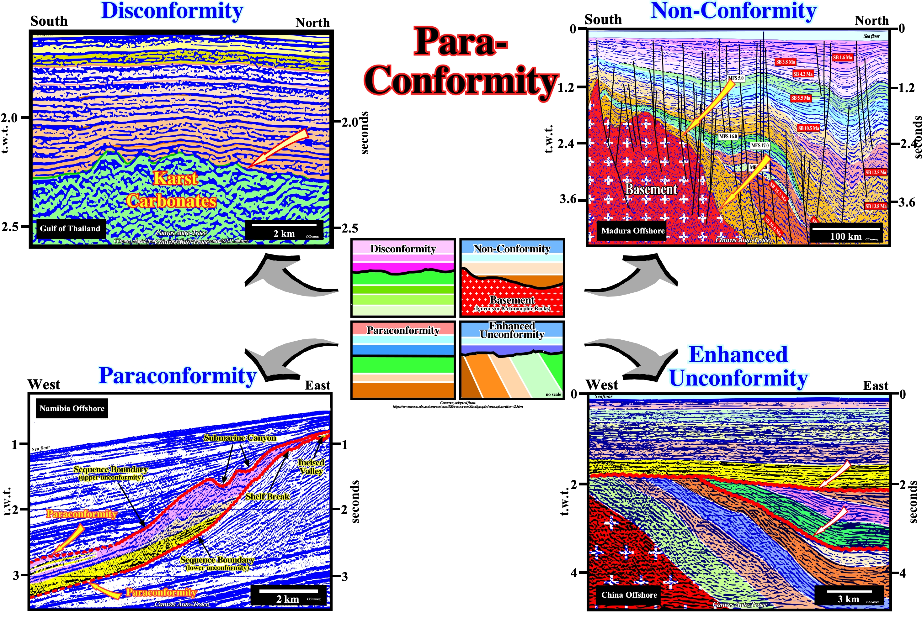
Figure 068- Disconformities are, often, erosional contacts that are parallel to the bedding planes of the upper and lower rock units. However, laterally, they cam become cryptic unconformitises, as illustrated on the tentative geological interpretation of the Canvas auto-trace of a Gulf of Thailand seismic line. A non-conformity (Madura offshore Canvas auto-trace) is the contact that separates a younger sedimentary rock unit from an igneous intrusive rock or metamorphic rock unit. It suggests a period of long-term uplift, weathering, and erosion occurred to expose the older, deeper rock at the surface before it was finally buried by the younger rocks above it. n the tentative geological interpretation of the Canvas auto-trace of a China offshore seismic line, twwo tectonically enhanced unconformities (angular unconformities) are, easily, recognized. This offshore corresponds to the stacking of four types of basins of the Bally and Snelson (1980) sedimentary basins classification : (i) Basement, which probably corresponds, to a large extent, to Precambrian a folded belt ; (ii) Paleozoic flattened folded belt ; (iii) Mesozoic-Cenozoic back-arc basin, within which one can distinguish half-grabens, developed during a rifting phase, covered by sediment deposited during the sag or thermal phase, and (iv) Cenozoic non-Atlantic type divergent continental margin. A large Paleozoic sedimentary package was deposited over the basement, which is, probably, composed of rocks of Precambrian age, which later, due to successive compressional tectonic regimes, became a folded belt, which, at the end of the Paleozoic Era, became a peneplain. The Paleozoic interval is separated by a tectonically enhanced unconformity, i.e., an unconformity induced by a relative sea level fall and reinforced by tectonics, which is easy to recognize, taking into account the reflections terminations, particularly the toplap by truncation (upper terminations).Above this unconformity the sediments of the back-arc basin were deposited, whose beds have a very different dip. A new compressional tectonic regime shortened the rocks that were lifted and eroded. The erosional surface underlines a new peneplain that was covered during the Cenozoic by a non-Atlantic type divergent margin. The upper unconformity between the Paleozoic/Mesozoic sediments and the Cenozoic margin sediments is also an angular unconformity, although the overlying intervals are parallel to the unconformity and have a parallel internal configuration. This type of unconformity can not be followed or picked (tracked) in continuity. The geoscientist is forced to jump from reflections crests to troughs or the opposite, every time the acoustical impedance contrast changes. Tectonically enhanced unconformities, although they are the easiest to recognize in field or seismic lines (taking into account the reflector terminations of the intervals they separate), are relatively rare and local, while the most frequent are cryptic unconformities, whose identification is made, above all, from the recognition of the submarine canyons and incised valleys fills. On the tentative interpretation of a Namibia offshore seismic line (detail), the three members of a lowstand systems tracts group of an incomplete sequence-seismic are, easily, recognized between the unconformities or the correaltive deep-water paraconformities bounding an incomplete sequence cycle. From bottom to top, it is quite easy to identify (i) the basin floor fan (BFF), in yellow, (ii) the slope fan (SF), in light brown and (iii) the lowstand prograding wedge (LPW), in violet. Submarine canyons (SC) and incised valleys fills (IVF) are pinpoint on the upper and lower sequence boundaries. Shingled turbidites are identified on the toe of progradation of the lowstand prograding wedge.
d.2.3) Depositional hiatuses can be defined by :
- A Toplap/Downlap interface, which indicates, respectively, a sub-aerial environment over a sub-aqueous depositional environment ;
- A Downlap/Apparent Truncation interface, which indicates, respectively, a sub-aqueous over a subaqueous depositional environments and
- An Onlap/ Conformable interface, which indicates two a sub-aqueous depositional environments.

Figure 069- Depositional hiatus are characterized by downlaps with toplap in the upward reflection terminations. However, in certain instances, the interface can be defined by downlaps over apparent truncations or onlaps over a conformable lower sedimentary package. Generally, a toplap and an onlap suggest subaerial environments, while a downlap, apparent truncation (top of a backstepping interval) and a conformable relationship suggest subaqueous environments. Summing up: (i) Onlap and toplap are associated with subaerial environments, While (2) Downlap, apparent truncation and conformity are, mainly, associated with subaqueous environments (occurring under water). Two major non-depositional hiatus surfaces (dashed blue) defined by downlap reflection terminations are quite evident on this tentative interpretation (North Caucasus trough). These surfaces emphasize the geologic-time interval during which no strata was deposited at the depositional surface. The progradational (forestepping) geometry of the depositional systems implies a progressive fossilization of an underlying depositional surface. The hiatus duration increases seaward, i.e., in the direction of the downlap terminations. Some of the toplap terminations are deposition and other erosional. The first do not highlight cycle boundaries, what is the case for the erosional toplaps.
c) Diachronic Surfaces
A stratigraphic limit, which separates rocks of different sedimentary environments or facies (lithology), can be : (i) synchronous, i.e., parallel to the stratal surfaces or (ii) diachronous, that is to say, oblique crossing the stratal surfaces. In this group are included the retrogradational transgressive surfaces and in seismic data, the reflectors associated with gas /oil or gas /water plane contacts (bright stops).
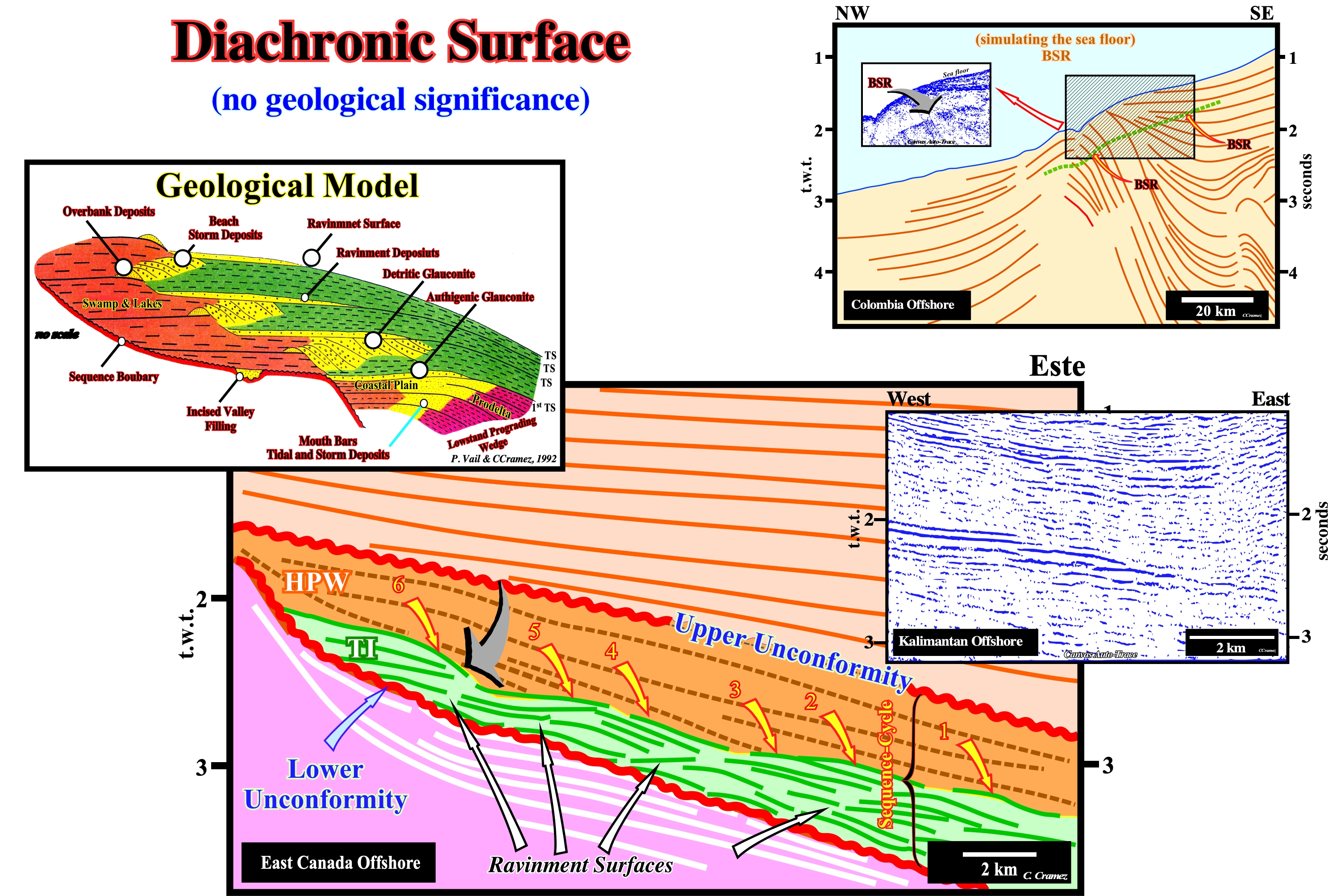
Figure 070- Diachronic surfaces, oblique to chronostratigraphic lines, are, sometimes, found on seismic lines, in association with accumulations of hydrocarbons. Likewise, in the deep offshore seismic lines, diachronic horizons, which emphasize the top of the clathrates levels, mimic, sometimes, the sea floor, as illustrated in this figure by a Canvas auto-trace of a seismic line of the NW Colombia offshore. On this tentative interpretation a diachronic seismic reflector is, easily, recognized about 0.5 seconds below the sea floor. This reflector, which simulates the bottom of the sea (BSR or Bottom Simulating Reflector) is caused, mainly, by the gas bubbles at the base of the gas hydrate stability zone (GHSZ), which, consequently, can not act as a cover. The porosity is filled to more than 95% by water. The gas hydrate stability zone occurs in oceanic sediments in the first few hundred meters below the sea floor. In this zone, any methane from an organic material, including any exudation from deeper areas, is converted to a solid hydrate, and is blocked in the sediments. The origin of methane is poorly understood. Even its biogenic origin is being challenged. On the Canvas auto-trace of a seismic line of Kalimantan offshore (Indonesia), the retogradational limit of the top of the transgressive interval of a sequence-cycle is obvious. On the tentative geological interpretation of a Labrador Sea seismic line, within a sequence-cycle, induced by a 3rd order eustatic cycle, whose time-duration varies between 0.5 My and 3.5 My, the transgressive interval (TI), which certain geoscientists call, inappropriately, transgressive systems tract is, easily, recognized between the lower unconformity of the sequence-cycle and the highstand prograding wedge (HPW). The reflectors of the underlying sequence-cycle are represented by thick, white traces, while those of the transgressive interval (TI) are colored in green. The reflectors of the transgressive interval (TI) rest by coastal onlaps against the reflectors of the underlying sequence-cycle emphasizing an unconformity (erosional surface). Within the transgressive interval, the presence of four ravinement surfaces is observed and, between them, the reflectors progradate seaward. The transgressive interval, in its entirety, corresponds to the transgressions of C. Emiliani (1992), i.e., to a set of increasingly important marine ingressions (relative sea level rises) and increasingly smaller sedimentary regressions, which, creates, globally, a retrogradational geometry. As can be seen on this tentative interpretation, as well as in the geological model, since the first relative sea level rise, which floods the preexisting topography, the shoreline (more or less the depositional coastal break of the depositional surface) is displaced landward (marine ingression), creating on the deposited sediments, a ravinement surface. At the same time, a water-depth is created (development of the shelf within the sequence-cycle) and available space for the sediments (accommodation). During the stability period of relative sea level, which follows the marine ingression, the transported sedimentary particles, gradually, deposit in progradational sedimentary packages (sequence-paracycle) moving the shoreline, progressively, seaward, but without reaching its previous position. A shelf is thus initiated, between the continental edge and the new shoreline. A more important marine ingression than the previous one, again, shifts landward the depositional coastal break of the depositional surface, creating a new ravinement surface and increasing, again, the space available for the sediments. At the same time, lowstand geological conditions with a low sedimentation rate, are developed in the distal part of the platform (near the continental edge). More sediments will be deposit during the new stability period, in progradational packages, but, as before, the shoreline does not reach the extreme position it had before this relative sea level rise. New marine ingression, even more important, etc., etc. This geological history is repeated several times, until, finally, the new marine ingression is smaller than the previous one, i.e., until a relative sea level rise is deceleration, what starts the deposition of the highstand prograding wedge (HPW), during the stability period of relative sea level, as the shoreline begins to move, progressively, seaward diminishing the extension of the continental platform (shelf). It is important not to forget that a marine ingression* reduces the Earth's albedo (ratio of reflected light energy to incident light energy), since the sea surface absorbs more solar radiation than the Earth's surface. Thus, probably, the temperature gradient between low and high latitudes is reduced during large marine ingressions. Some of this reduction is attributed to the increase of the CO2 content in the atmosphere, increased volcanic activity along the mid-ocean ridges, and increased organic productivity. On the contrary, a marine ingression contributes to the deposition of fossil-rich marine sediments on the continent, which means that sedimentary regressions interrupt the marine sedimentation on the continent, at same time, as erosion reduces the sedimentary deposits, previously, settle down, which implies that the continuity of marine records in a given region of the continent, rarely, exceeds a few tens of millions of years. Thus a Phanerozoic continuous record can, just, be reconstructed correlating and joining different stratigraphic sections.