

Depositional Water-Depth
Taking into account that landward of the depositional coastal break, that as said previously, can coincide with the shelf break (when the basin has no shelf, i.e. in lowstand geological conditions), all the accommodation is filled by sediments, the depositional water-depth is, practically, zero. Seaward of depositional coastal break, along a chronostratigraphic line, the depositional water-depth increases basinward. It can be calculated using the geometry of the coastal plain as datum (water-depth zero).
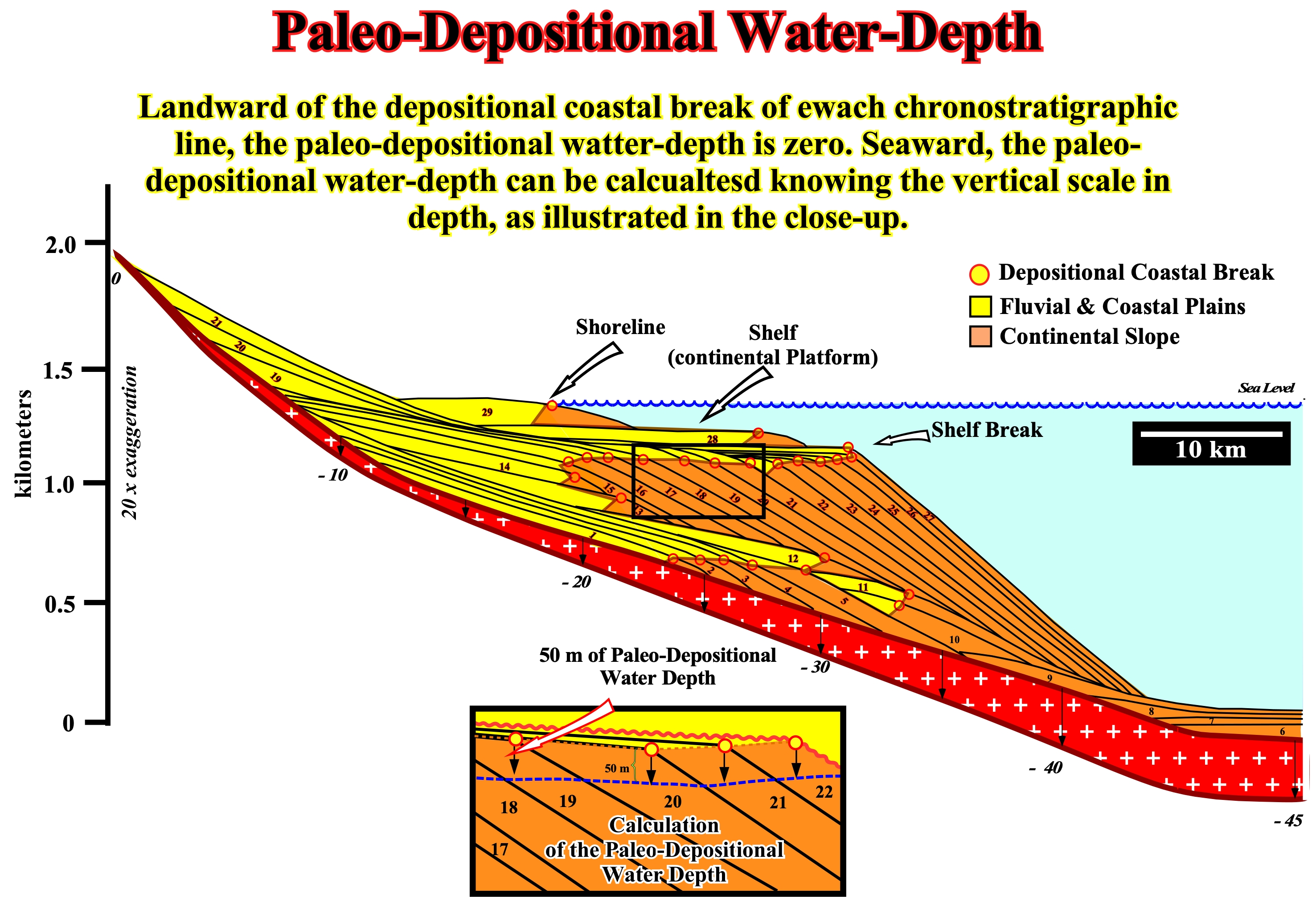
Figure 080- As illustrated in this sketch, along a chronostratigraphic line, when the basin has a shelf (platform), the depositional coastal break underlines, more or less, the shoreline, while the shelf break emphasizes the top of the continental slope. When the shelf break coincides with the depositional coastal break, that is to say, when the basins has no shelf, which happens most of the time during the regressive stratigraphic phase of a continental encroachment cycle, the paleo-depositional water-depth is zero. Taking as datum the coastal plain, it is possible to calculate the paleo-depositional water-depth, in time or in depth (if the interval velocities are known), seaward of the shelf break (depositional coastal break = shelf break coastal) as shown in this figure. For that, just to move downward, the line of zero of depth water zero (line joining the successive shelf breaks) and calculate the difference in time or in depth.

Figure 081- In this example, the paleo-depositional waterdepth along the continental slope can be calculated (in time, i.e., in double time) since depositional coastal break, which in this particular example, coincides with the shelf break. The basin at that time had no shelf. Two paleo-depositional water-depths, between 0.2 to 0.4 seconds (TWT) are, tentatively, calculated.
The accommodation is the available space for sediment. The variations of the accommodation reflect the space available for the sediments through a combination of subsidence and a relative sea level rise or fall. If space available is, entirely, filled or not, depends on the rate of terrigeneous influx arriving into the basin and the position of the considered point in respect to the depositional coastal break. The key for a good tentative sequential interpretation of seismic data or electrical logs is, for instance, the application of the concept of accommodation in the interpretation of depositional environments.
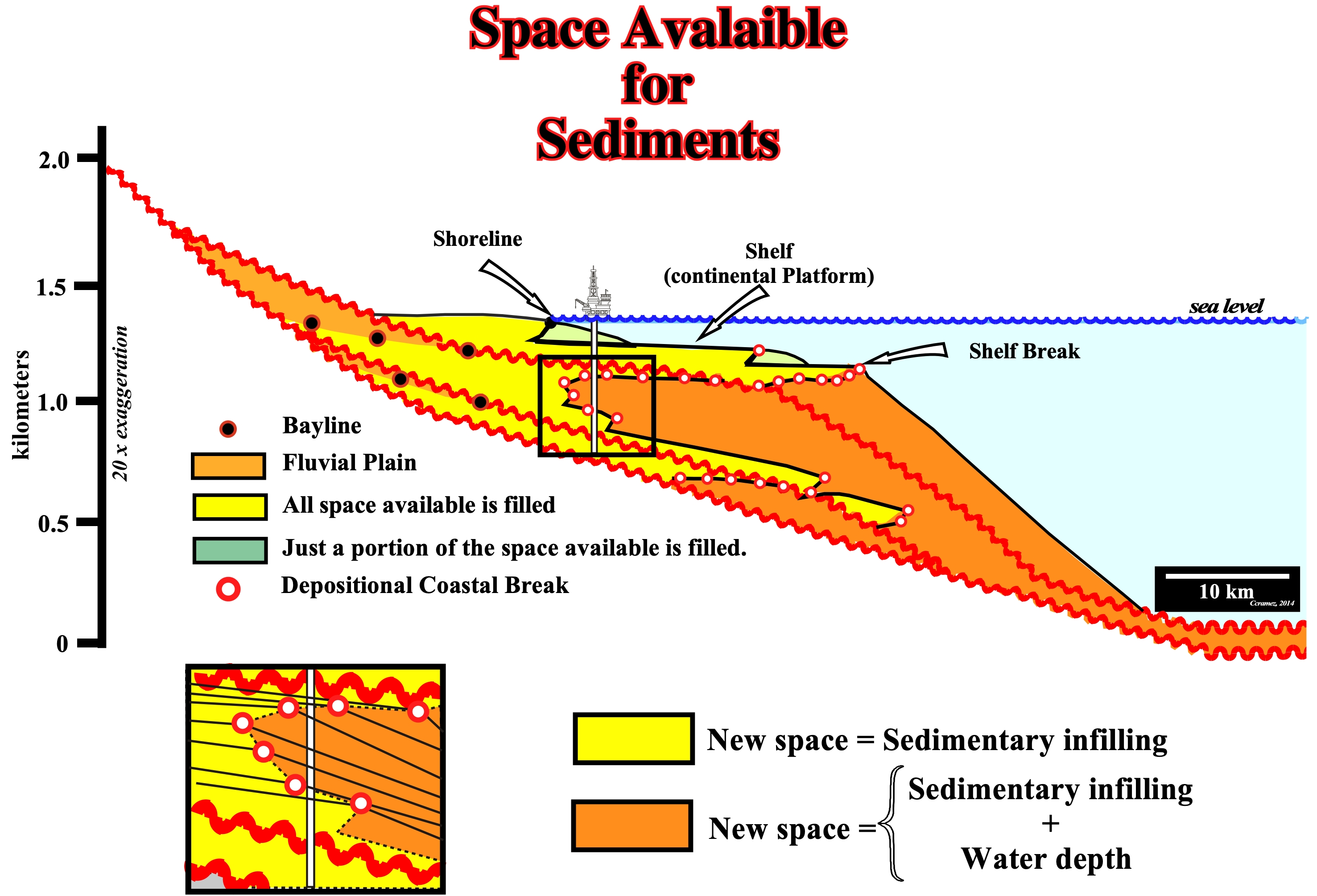
Figure 082- This figure shows the available space for sediments (accommodation) is, completely, filled (if the terrigeneous influx is sufficient) landward of the depositional coastal break, which here coincides with the shelf break. However, seaward of the shelf break, the new created space is equal to the height of the new deposited sediments plus the water-depth.
To identify the variations of the sedimentar accommodation several steps are recommended:
1) Location of the marine clays wedge :
- In siliciclastic stratigraphic section (sand-shale), this wedge occurs, usually, on the continental shelf, where it is covered and covers sediments more coarse and extends, laterally, to the continental slope and abyssal plain.
- In a carbonated stratigraphic section, the wedging of clays, marls and calacareous muds is, usually, covered by coarse clastic carbonates or by evaporites and is overlies transgressive carbonates.
2) Location, in deposited sediments on the platform (in the base of the wedge of marine shales), of the fining upward stratal patterns:
- In siliciclastic, these patterns, often, forme bell-shaped record and reflect the retrogradation of the successive paracyclos (of a sequence-cycle), since a rapid relative sea level rise oblige the shoreline to displace landward ;
- In carbonates, these patterns may be less visible in electrical logs and study of the cores may be necessary to recognize the fining upward patterns, as well as, the increasing the paleo-depositional water depth.
3) Location, in deposited sediments on the platform (above the marine shales wedge), of the coarsening upward stratal patterns :
- In siliciclastic, often, they form a a funnel geometry at the top of the wedge clay, representing the progressive progradation of the delta front sands, followed by deltaic and fluvial shale-sand sections, which represent a decrease of marine conditions ;
- Bathydecreasing upward patterns can be observed in carbonaceous, by studying the debris and drilling cores with the help of the biostratigraphy.
Bayline
The bayline is the demarcation line between the areas characterized by sub-aerial accommodation and a marine accommodation, that is to say, between the sediments of the alluvial plain and coastal plain or, in other words, between the fluvial and marine sediments, since the coastal plain sediments are considered as paralic deposits*. The bayline is, often, defined as the demarcation line between sedimentary zones characterized by sub-aerial and marine accommodation or limit between fluvial and paralic/deltaic environment.
The bayline (Figure 083) should not be confused with the shoreline (roughly the depositional coastal break), which marks, upstream, the limit of marine environments. In certain cases (absence of bays or lagoons). The bayline may have the same position as the shoreline. In sequential stratigraphy, it is used as a reference for river provisional equilibrium profiles.
* Deposits on the landward side of a coast, in shallow fresh water subject to marine invasions, i.e., marine and non-marine sediments are interbedded.
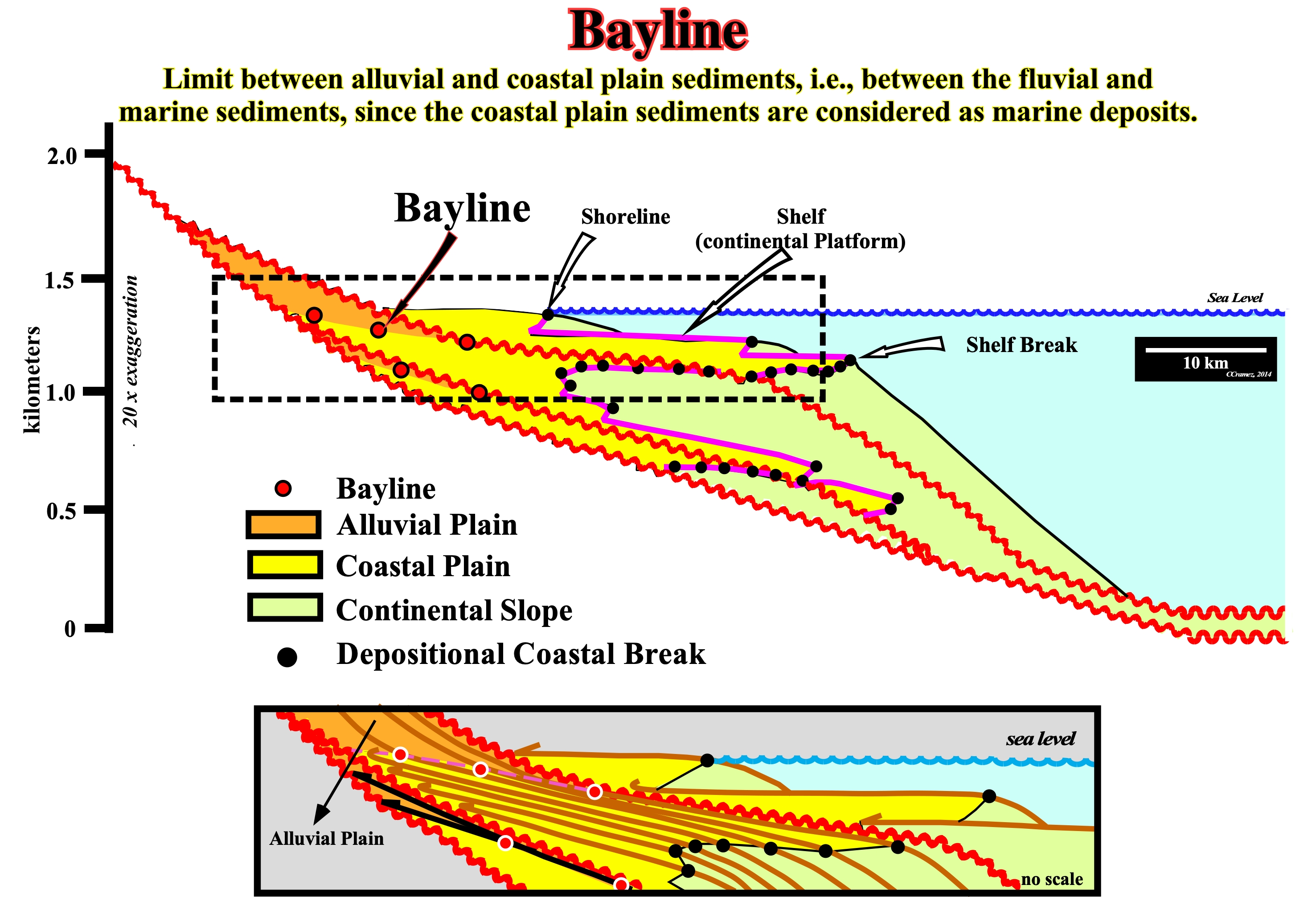
Figure 083 - As illustrated in this sketch, in highstand geological conditions (sea level above the shelf break), a bayline (boundary between the fluvial and no fluvial deposits) may be considered for each chronostratigraphic line.
In sequential stratigraphy, the successive positions of the bayline limit, upstream, the coastal wedge and not the coastal deposits. Posamentier and Vail (1988) consider the deltaic deposition occurs when a water-course finds a water-body, almost immobile, defined the bayline, more or less, as follows:
(i) The coastal plain forms by progradation processes of sea-floor, rather than exhumation ;
(ii) The sediments accumulated on the coastal plain, during the progradation of the coastline, form part of what is called the "coastal wedge or "coastal prism", which includes river and shallow-water deposits ;
(iii) The coastal wedge or coastal prism is wedge-shaped and extends continentward by onlapping on the pre-existing topography ;
(iv) The upstream limit of the coastal wedge is the bayline, which may move continentward when the progradation of the shoreline is accompanied by aggradation (Figure 084) ;
(v) The bayline is the boundary between the coastal plain and the alluvial plain ;
(vi) Upstream of the bayline, relative sea level changes have, practically, no influence on depositional systems.
However, for some geoscientists, the encounter of a water-course with an almost immobile water-body, which controls the provisional equilibrium profile of the water-course occurs at the mouth of a stream (head of the delta) not at the bayline. Thus, when speaking about equilibrium profiles of rivers, geoscientists should say whether the profile is in relation to the bayline (Vail's position) or to the shoreline (Miall's position, for example).
Figure 084- Landward of the bayline, the rate of relative sea level fall is larger than the rate of subsidence. On the contrary, seaward, the rate relative sea level (eustasy plus subsidence) is lesser than the rate of subsidence. It is important to note that in the tentative geological interpretation of the seismic line, the paracycles forming the transgressive systems tract, have a progradational internal configuration. This means that a transgression is a succession of regressions each time less important, which gives to the transgressive systems tract a global retrogradational geometry. On this geological tentative interpretation of a Canvas auto-trace of a detail of a Labrador offshore seismic line, the upper unconformity separates two sequence-cycles. Throughout this unconformity, two slope breaks (change in dip of the depositional surface) are, easily, recognized. The first, (more seaward), corresponds to the continental edge of the highstand prograding wedge (HPW) of the lower sequence-cycle (at that time, the basin does not have a shelf, i.e., the shoreline coincided, more or less, with the basin edge and with the continental edge). The second break (upstream of the first one corresponds to the bay-line, which separates, in the highstand prograding wedge of the lower sequence-cycle, the fluvial deposits (upstream of the bay-line), from the coastal deposits (influenced by relative sea level changes). Above the upper unconformity, several sequence boundaries are recognized by the seismic surfaces emphasized by coastal onlaps, as well as, the transgressive interval. This transgressive interval corresponds to the set of five (5) marine ingression increments increasingly important (eustatic paracycles), which induced five sedimentary regressions increasingly smaller (sequence-paracycles), within, at least, two depositional systems are, more or less, evident.
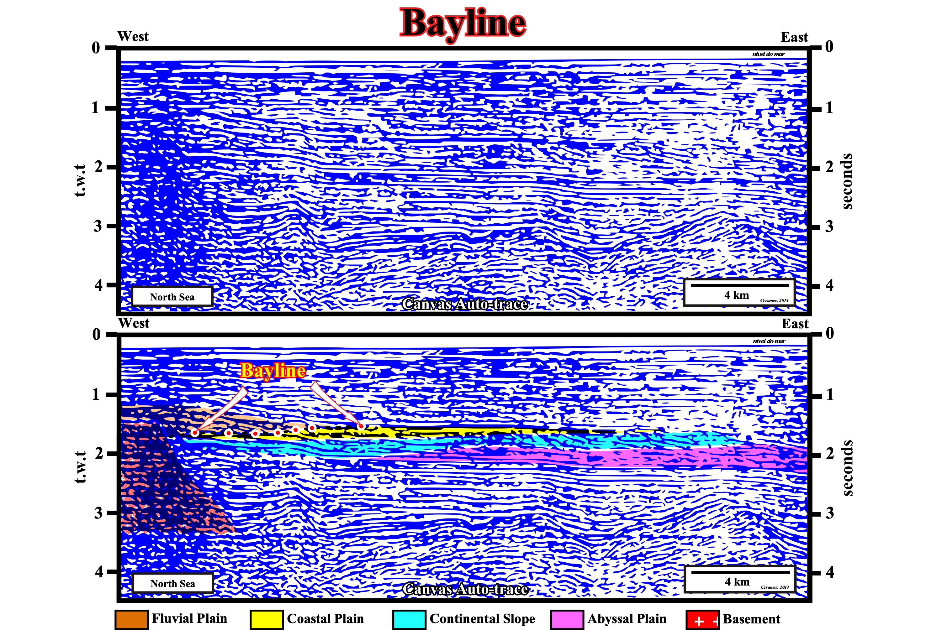
Figure 085- In this seismic line from the North Sea, within the progradational interval of cratonic basin, in each chronostratigraphic line, it is possible to recognize different dipping breaks in the depositional surface. The breaks associated to the baylines, as well as the depositional coastal breaks (the basin appears to have no shelf, which means that depositional coastal break coincides with the shelf break or continental break) and, even, the breaks of the base of the continental slope (which is not very thick) are clearly visible. Note that the morphology of the base of the cratonic sediments, which emphasizes a late tectonic activity of the underlying rift-type basins.
Note that a depositional surface (chronostratigraphic line) has several slope breaks. From deep-water to continent, the main breaks of the depositional surface are: (i) Lower Continental Slope Break ; (ii) Upper Continental Slope Break or Continental Break ; (iii) Depositional Coastal Break ; (iv) Bayline or Alluvial Break.
- The lower continental slope break separates the abyssal plain from the base of the continental slope ;
- The upper continental slope break or continental break marks the limit between the continental slope and the continental platform (when the basin has as shelf) or it marks the limit between the continental slope and the coastal plain, when basin edge coincides with the continental break (when the basin has no shelf, lowstand geological conditions),
- The depositional coastal break corresponds, more or less, to the shoreline and separates the marine deposits from the paralic deposits.
- Bayline or alluvial break corresponds to the limit between the fluvial and coastal plain.
For the followers of sequential stratigraphy, it is alluvial break that defines the bayline, i.e., the point where the provisional equilibrium profile of the rivers becomes, more or less, horizontal and where the effects of subsidence and eustasy (absolute sea level, which is supposed to be global and referenced to the Earth’s center) cancel out (as shown in figures 084 & 085).