

Part Four
(Rational Geological Interpretation of Seismic Lines)
Nature Principles
The knowledge of Nature Principle is fundamental for the undertstanding of Geology, which is indispensable to know what geoscientists must look for on seismic lines when trying, tentatively, to interpreted them. Nature is ruled by some basic principles: a) Inequality ; b) Self-Similarity ; c) Fractal Distribution ; d) Cyclicity ; e) Finiteness ; f) Gravitation ; g) Life ; h) Determinism & Probabilism and i) Symmetry (Central Limit Theorem).
a) Inequality- equality may exist at the starting line, but at the end, there is usually only a winner. Just demagogue politicians try, unsuccessfully, to convince electors that equality is a ruler in Nature. USA has 5% of the world population, spends 25% of the energy in world, has 40% of the autos in the world, represents 60% of the world commerce and has 70% of the lawyers in the world. Inequality is a characteristic of oil and gas fields: Ghawar oil field, the King of kings, with five (5) others kings and 15 other oil fields represent 90% of world reserves outside USA and Canada.
b) Self-Similarity- Nature is characterized by self-similarity. Natural objects have a fractal geometry. A natural object, or geometric figure, is fractal when (i) its parts have the same shape (structure), in spite of their scale or deformation ; (ii) Its shape is either irregular, interrupted or fragmented independently the scale of observation and (iii) 3t contains distinctive elements, which scales are very varied and covering a very wide range. Geoscientists know a scale is necessary to interpret an outcrop or seismic line. Geology is scale dependent.
c) Fractal Distribution- Natural objects, or natural events, when listed in decreasing size and plotted on a log-log format with size against rank show a parabolic fractal distribution. Galactic intensity, Town sizes, Reserves, Field sizes, HC accumulations within a given PS, etc., have a fractal parabolic distribution.
d) Cyclicity- All natural events can be depicted by one or several cycles. Nothing is eternal. What is born will die. What goes up will come down. Sun, Earth, mankind, civilization, etc. will die. Since long time, geoscientists notice the cyclicity of deposition systems and tried to explain it.
d1) After Benoit de Maillet and Lavoisier, the majority of them assume that Eustasy, i.e., absolute sea level variations, is the mainly source of the cyclicity of the depositional systems.
d2) The Earth’s history, at least since Phanerozoic (600 Ma), can be depicted as cyclic. After the gathering of the Proto-Pangea supercontinent, it broke in several continents, which dispersed to a maximum, by sea floor spreading, before gathered, again, to form the Pangea. Then, the Pangea broke-up in several continents, which after dispersion are gathering to form a new supercontinent. These major geological cycles, recognized by Wilson Tuzco, are known as Wilson’s cycles.
d.3) The Plate Tectonics paradigm, which is a cyclic theory, explains quite well the correlation between major geologic events, which are interlinked and interconnected. Indeed, they cannot be understood in isolation. A systemic, or global approach, is required to understand the whole, which is much more than the sum of the parts. Detail studies can be fascinating, but, unfortunately, we learn from generalities.
d4) The number of wells drilled in petroleum exploration, as all natural events, seems to be cyclic. Such a cyclicity can be due to demand problems, new plays (turbidite depositional systems), new technology (deepwater drilling or seismic acquisition), etc.
e) Finiteness- Infinite, as perpetual growth, does not exist. Earth, as well Universe, is limited. In the Nature, there is no permanent growth, that is to say, all which is born, has to die, or all which rises, has to come down again. Suppose a bacteria doubling every 30 minutes. After one week all Solar System will be filled, and after 11 days all Universe will be filled.
e1) The rate of decline varies according to the volumes each field was producing when it peaked.
e2) Hydrocarbon output begins to decline as encroaching water and gas simply crowd out the oil (M. Simmons, 2005).
e3) Since 1960 the oil discoveries are smaller and smaller.
e4) Any large oil field as Burgan, Zuata or Ghawar was found since the 60's. Indeed, it is quite evident that we are leaving from the past.
e5) Since 1960 the oil discoveries are smaller and smaller and since the 80s the majority of oil companies, and particularly the majors, are enable to replace their production.
f) Gravitation- Einstein show the way matter curves space-time to visualize the force of gravity between masses. Everything is curved. Linearity exists only locally.
f1) The geoid is the most graphical representation of the Earth gravity field. The largest positive geoid heights are associated with subduction zones and hotspots and have no simple relationship to other high regions such as continents and ridges.
f2) As sea level is not uniform. A global rise of 10 meters, induced for instance by a deglaciation, does not give the same relative consequences all around the Earth. Probably, in sequence stratigraphy, the majority of unconformities have a regional extend but not global.
f3) Sediments must be transported before being deposited, so gravity plays also an important role. All clastic sediments are deposit by gravity. Fluvial, marine, eolian, pyroclastic and glacial deposits are all controlled by gravity.
g) Life- Life is everywhere. Live can be found in all environments, continental, subaerial, aerial, desertic, fluvial, shallow marine, depth marine, even in hadal depths. Life is controlled by three major laws: (i) Fermat-Maupertius’s law or Principle of minimum action ; (ii) Snell’s law or Principle of minimum time ; (iii) Fibonacci’s law or Principle of maximum room.
(i) Fermat-Maupertius’s law- “Entia non sun multiplicanda praeter necessitatem”, i.e., entities should not be multiplied unnecessarily (Ockham, W., 1290-1349). P. de Maupertius (1744,) put forward that physical events followed a basic principle: “Nature follows always, among all possibilities, the more efficient one”. In the case of movement, for instance, such efficiency corresponds to the minimum velocity for the minimum of traversed path (Principle of minimum action).
(ii) Snell’s law - During the refraction of light, the ratio of the sine's of the angles of incidence and refraction is a constant equal to the refractive index of the medium. The reflection case illustrates a point about Format's principle: the minimum time may actually be a local rather than a global minimum. Trajectories allowed by Format's principle don't strictly have to be minimum time trajectories. They can also be maximum time trajectories.
(iii) Fibonacci’s law - In a Fiobonacci sequence each term (after the first two) is the sum of the preceding two: 1, 1, 2, 3, 5, 8, 13, 21, 34, 55... This simple pattern can determine the shape of a seashell, pine-cones or the sprouting of leaves from the stem of any plant. This connection to the organic world is reflected in the surface pattern, which is achieved through the process of smoke firing. Fibonacci sequence has many other interesting mathematical properties. For example, the ratio od successive terms (larger to smaller; 1/1, 2/1, 3/2, 5/3, 8/5, 13/8....) approaches the number 1.618 (phi). This ratio is known as the Golden Ratio. The architecture of a Nautilus’ shell can be compared with a series of nested Golden Rectangles obtained when you snip off squares from a Golden Rectangle. If we connect the successive points where these whirling squares divide the sides in Golden Rations, we obtain a logarithmic spiral that coils inward toward the pole (the point given by the intersection of the diagonals, which was called fancifully “The eye of God”).
h) Determinism & Probabilism- Natural evolution is a succession of stages described by determinist laws and stages described by probabilistic laws. Nature is not linear. Problems need multi-solutions. Reject any single solution. Favor multi-solutions. Maths does not solve all problems. Trial and errors often gives better results. Finally, do not hide errors but try to not repeat them.
i) Symmetry- Symmetry is a major characteristic of Nature. One speaks of symmetry when a quantity remain unchanged during a transformation. A shape has line symmetry when one half of it is the mirror image of the other half. Symmetry exists all around us and many people see it as being a thing of beauty. Symmetry exists also in music. An example particularly clear is given by the composition, probably apocryphal, of a piece of music in two parts (Mozart ?), which starts by: Central Limit Theorem (In probabilities, adding a large number of asymmetric distributions gives a symmetrical normal distribution).
Geological Conjectures
Conjecture 1
Seismic lines are a high-resolution tool for determining the chronostratigraphy : On a seismic line there are, mainly, time lines. Facies lines are not too evident.
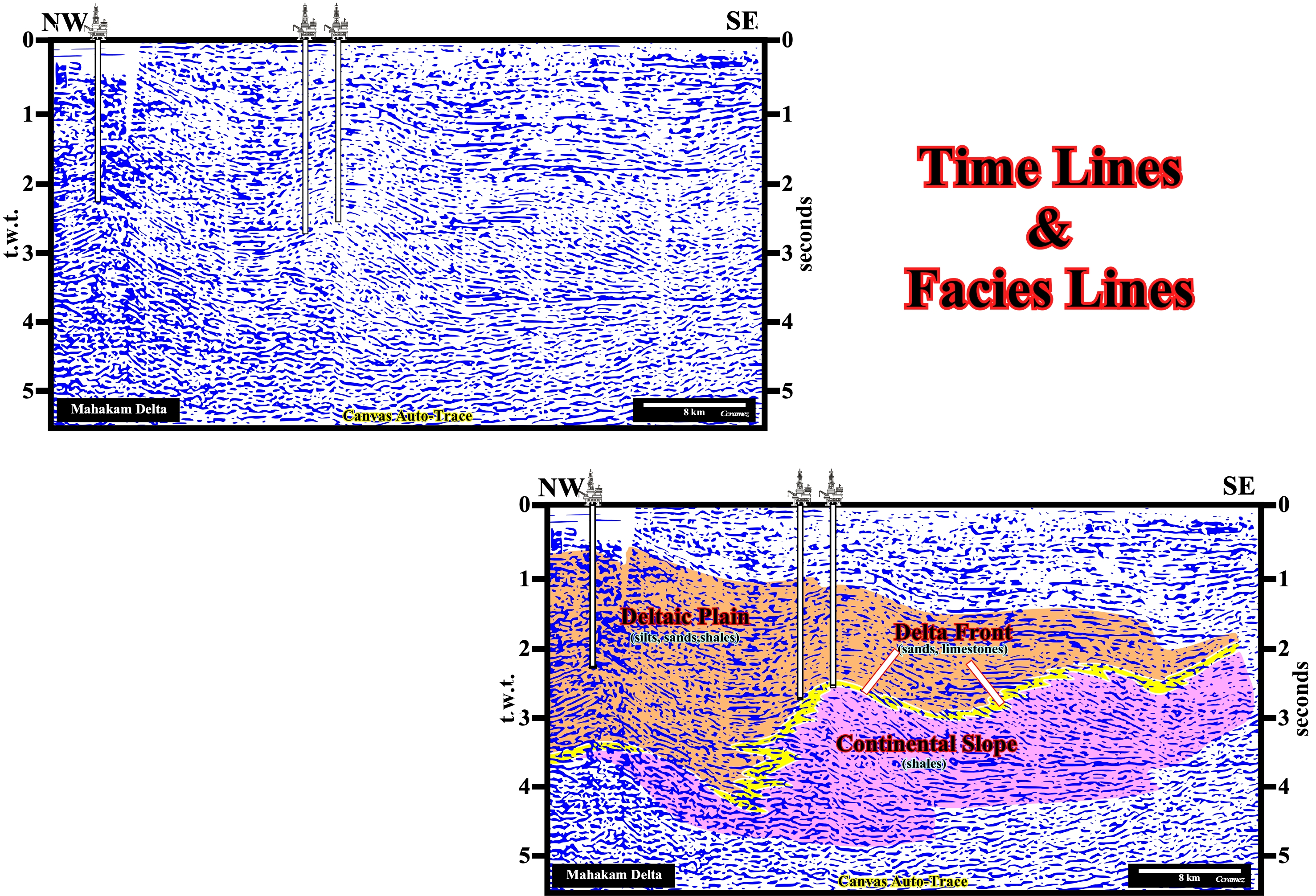
Figure 134- This seismic line from the Mahakam (Indonesia) offshore illustrates, perfectly, the seaward progradation of deltaic systems (SE). Seismically (taking into account the seismic resolution, that on this line is about 30-40 meters), the basin has no shelf. The depositional coastal break is, virtually, coincident with the shelf break (continental break). The transgressive intervals, and particularly, the transgressive systems tracts of sequence-cycles cannot be put in evidence. In tentative geological interpretation in facies (lithology plus fauna), shown on the bottom line, the facies lines, which are not highlighted by any seismic reflector, cut, clearly, the chronostratigraphic lines, i.e., the seismic reflectors. This fact, which was first observed in the 60's by the geoscientists of Exxon, when exploring the Guinea Bissau offshore, is observed all seismic lines. Along a reflector (chronostratigraphic line) there are several lithologies and sedimentary environments.
Conjecture 2
The cyclical nature of the stratigraphic succession can be explained by Eustasy.
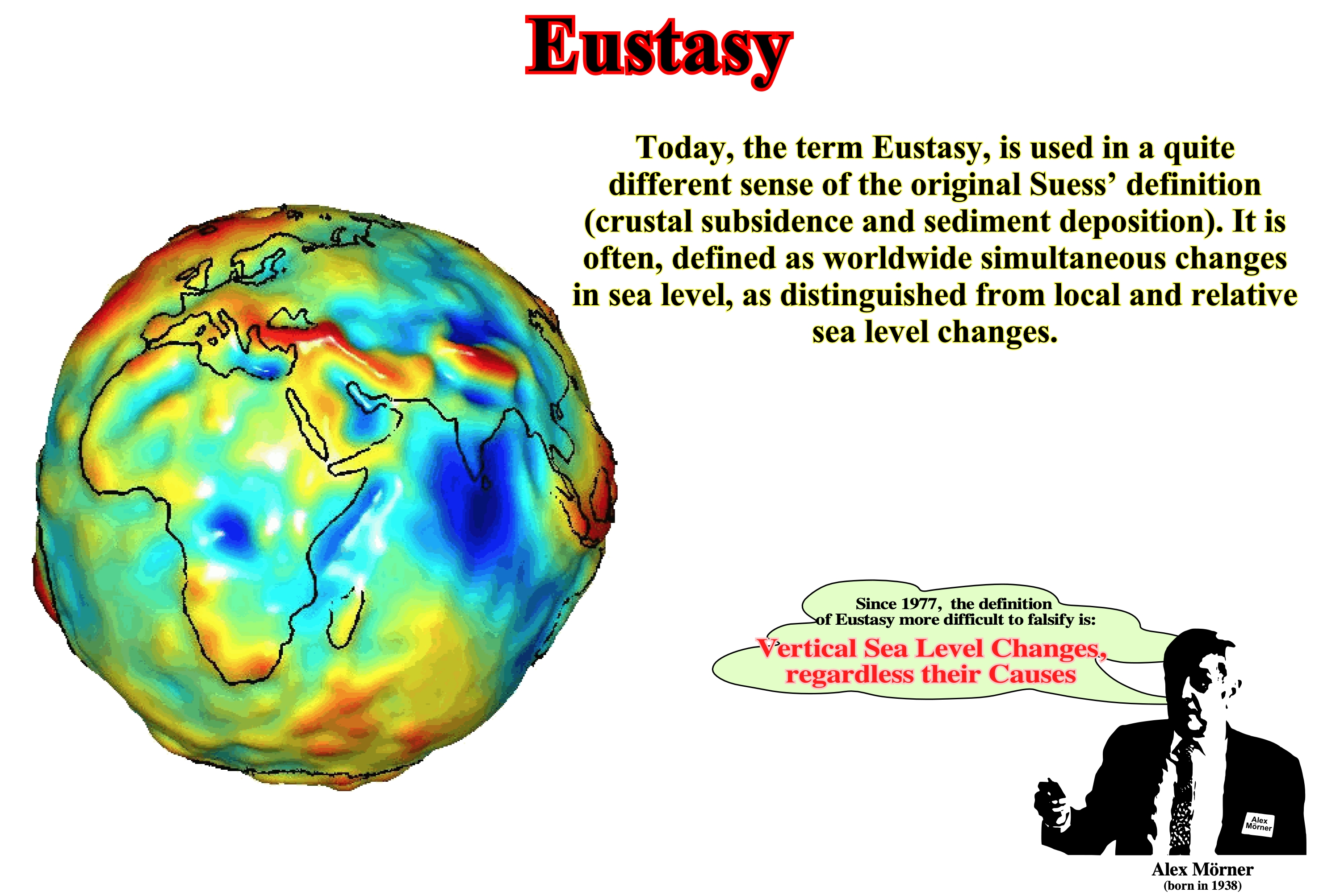
Figure 135- The average surface of the ocean or marine geoid, which after the hydrostatic laws, is an equipotential surface, is not perfectly spherical nor the gravity field of the Earth is, perfectly, homogeneous. In this model, the reddish colour indicates a gravity field stronger than the average. Blue indicates a weaker gravity field than the average. Eustatism, that is to say, the relative variations of sea level, is regarded as the determining factor of the cyclicity of sedimentary deposits. The role of tectonic is mainly linked to the amplitude of accommodation. An eustatic rise is rarely more than 10-15 meters. However, when associated with a subsidence of 100 meters, for example, the available space for sediment (map) is 100-115 meters. On the other hand, the rate of eustatic variations is much faster than the rate of subsidence variation.
Conjecture 3
The long-term eustatic changes are induced by plate tectonics.
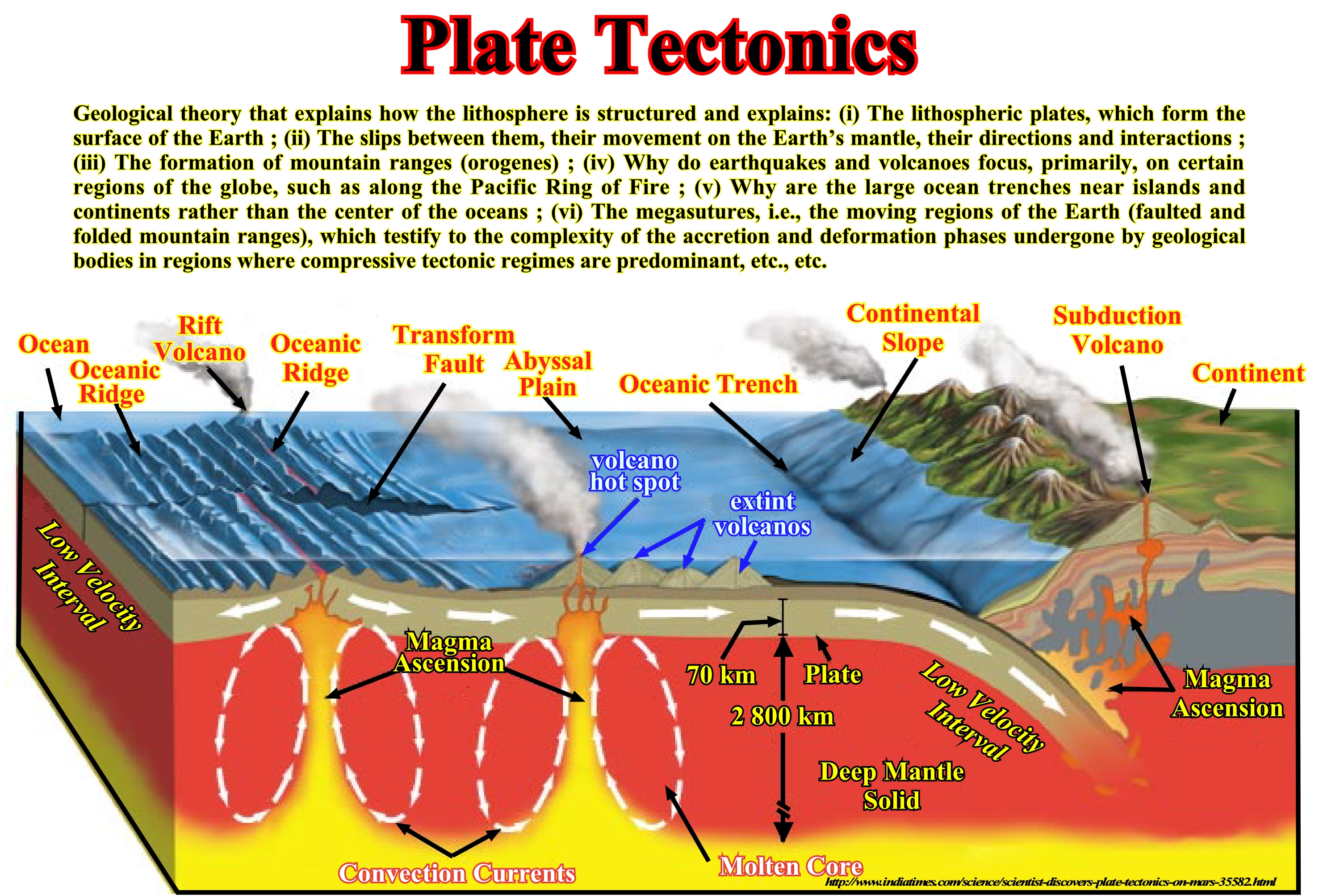
Figure 136- In plate tectonics theory, oceanic crust is created in the mid-oceanic ridge. The older and denser oceanic crust of a tectonic plate enters in subduction, i.e., it slides under another plate along the so-called Benioff zones (or B-type subduction). The subduction of the crust varies the volume of the ocean basins, which, at long term, is one of the causes of the eustatism, since the volume of water, in all its forms, is assumed to be constant. Almost all geoscientists think that the amount of water, in all its forms (liquid, solid and gaseous), is constant since the birth of the Earth about 4.5 Ga (10^12 years ago, twelve million million years ago or 12 billion years ago). Function of the amplitude of the ocean ridges the volume of ocean basins varies. In oceanic spreading phase, the volume of ocean basins decreases, since there is formation of oceanic mountains (oceanic ridges), which produces an eustatic rise. Unlikely, when the continents begin to approach each other due to the subduction of ancient oceanic crust and oceanic ridges along the B-type subduction, the volume of the oceanic basins increases, which causes an eustatic fall.
Conjecture 4
The stratigraphic cycles induced by 3 order eustatic cycles of are the sequence cycles, which, usually, are under seismic resolution. Just in areas with very high deposition rate, the sequence-cycles can be recognized and map on the seismic lines. However, at natural or full-scale 1: 1, that is to say, in the field, sequence-cycles are clearly visible, as well as, on the electric logs.
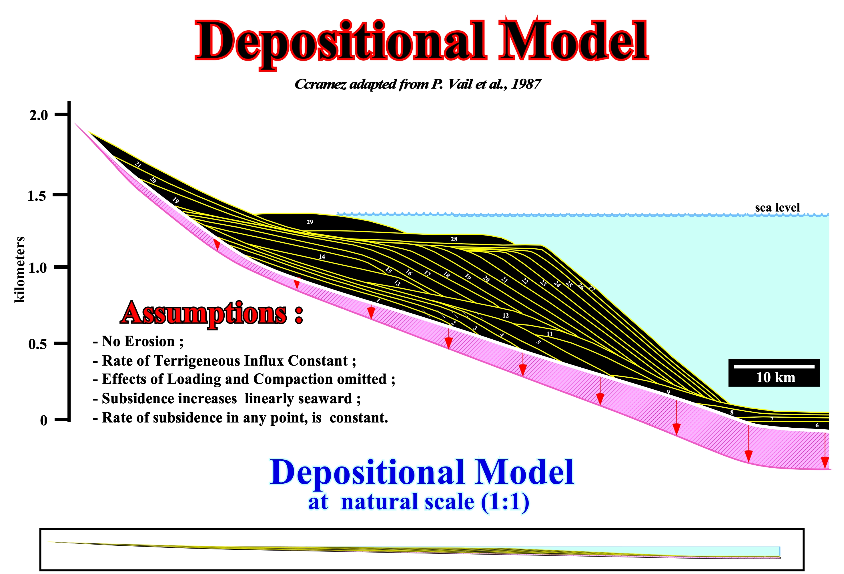
Figure 137- In this depositional model (quite exaggerated vertically) are represented three sequence-cycles, two of which are incomplete. From bottom to top: (i) Intervals 1-5 form the lower incomplete sequence-cycle ; (ii) intervals 6-21, form a complete sequence-cycle ; (iii) Intervals 22-29 form the upper incomplete sequence-cycle. The sequence-cycles are limited by erosional surfaces (unconformities), induced by relative sea level falls, which can be recognized by onlaps and toplaps. All these sequence-cycles consist of paracycles induced by eustatic paracycles, that in this model last 100.000 years (the age difference between 2 and 1, 3 and 2, or 15 and 14 is always 100.000 years. The complete sequence-cycle (6-21) is formed by different depositional systems tracts : A) 6 and 7 form the basin floor ; B) 8 and 9 form the slope fans ; C) 10 and 11 form the lowstand prograding wedge ; D) 12, 13 and 14 form the transgressive systems tract ; E) 15, 16, 17, 18, 19, 20 and 21 form the highstand systems tract. The basin floor fans, designed by the acronym CSB, the slope fans (CST) and the lowstand prograding wedge (LPW) form the lowstand systems tract (LST) . Conventionally, in sequence-cycle, geoscientists considered just three systems tracts : (I) Lowstand systems tract (LST), in which three members can differentiated ; I.1 - Basin Floor Fans (BFF) ; I.2 - Slope Fans (SF) and I.3- Lowstand prograding wedge (LPW) ; (II) Transgressive Systems Tract (CST) and (III) Highstand Systems Tract (HST) or Highstand Prism (HP). As shown at the bottom of this figure, at full-scale (natural scale 1:1), this model, none of the sequence-cycles (complete or incomplete) can be put en evidence. AS, in general, a conventional seismic line (unmigrated or migrated) has a vertical time scale exaggerated between 3 and 5 times over the horizontal scale (metric), is easy to understand why the sequence-cycles are difficult to highlight.
Conjecture 5
The geological knowledge preceds all observation of seismic data :
Theory precedes Observation (K. Popper, 1934).
How to observe or identify, on seismic lines, intervals with source-rocks characteristics ?
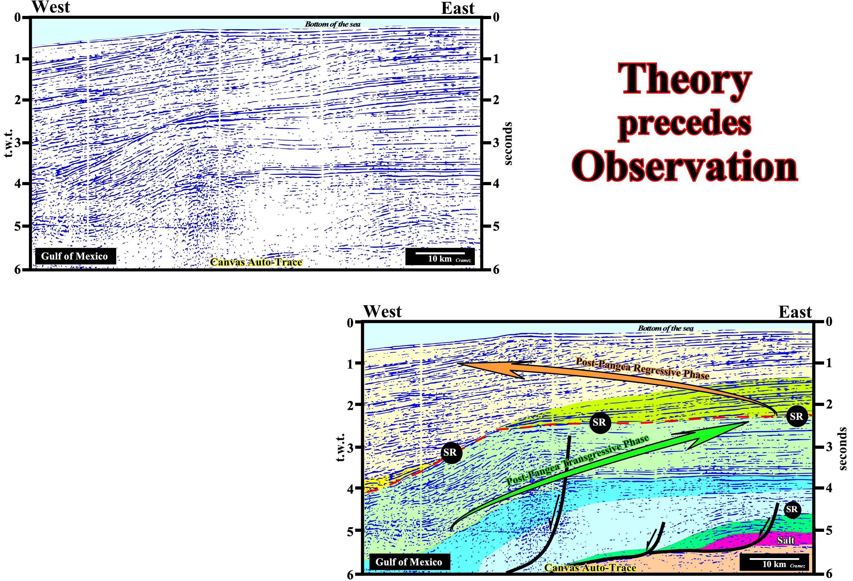
Figure 138- In this tentative geological interpretation of a seismic line from the Gulf of Mexico (the clean line is illustrated at the top), geoscientist who made the tentative interpretation knew, a priori, that : (i) The Gulf of Mexico corresponds to a Mediterranean-type basin ( divergent margin following the oceanization of a fold belt) ; (ii) The divergent margin is associated with the post-Pangea continental encroachment cycle, which is formed by two stratigraphic phase, as illustrated in the following figure ; (iii) The transgressive stratigraphic phase (highlighted by the green arrow) has a retrogradational geometry, while the regressive stratigraphic phase (highlighted by the brown arrow) has a progradational geometry. The boundary between these two phases is the Cenomanian / Turonian downlap surface, with which are associated with the most likely marine source-rocks. Secondary or alternative marine source-rocks are possible in the lower part of the margin, particularly, in limestone interval overlying the evaporitic interval.
Theoretical Principles
Stratigraphic Cycles
One of the basic principles of sequential stratigraphy is the conjecture that stratigraphic cycles are induced, primarily, by eustasy (changes of the absolute or eustatic sea level, i.e., from the supposed global sea level referenced to a fixed point, which is, in general, is the Earth's center, The absolute sea level is dependent on (i) Tectono-Eustasy (controlled by the volume variation of the ocean basins) ; (ii) Glacio-Eustasy (controlled by the variation of ocean water volume, mainly associated with the amount of ice) ; (iii) Geoidal-Eustasy (controlled by the distribution of ocean water caused by variations in the terrestrial gravity field) and (iv) Thermal expansion of the oceans or steric sea level rise (if the temperature of the oceans increases, the density of the water decreases and for a constant mass the volume increases.) Eustasy is the main factor responsible for cyclicity and an important factor in the creation of available space for sediments (accommodation). As far as cyclicity is concerned, since B. de Maillet (around 1690) and Lavoisier (1789) until today, almost no geoscientist has any doubts. With regard to the amplitude of space created during a relative sea level rise, it depends, fundamentally, on subsidence and/or uplift of the sea floor, since, relative sea level is the result of the combined action of absolute (eustatic) sea level and tectonics. The hierarchy of stratigraphic cycles depends on the order of the eustatic cycles, which induced them. In general, in seismic stratigraphy, made from seismic data (taking into account the seismic resolution), three main stratigraphic cycles are considered, which are deposited during 1st, 2nd and 3rd order eustatic cycles, that is, cycles eustatic cycles with time-durations, respectively, greater than 50 My (1st order), between 50 and 3-5 My (2nd order), between 3-5 and 0.5 My (3rd order*): (i) Continental Encroachment Cycle ; (ii) Continental Encroachment Subcycle; (iii) Sequence-Cycle and High Frequency Cycles **. The sequence-paracycles that form a sequence-cycle are not cycles. There is no relative sea level fall between them. They are bounded by flooding surfaces. Continental encroachment cycles are associated with the break-up of supercontinents (Protopangea or Rodhinia and Pangea supercontinent, for instance), as it is the case of the two Paleozoic continental encroachment cycles of the Phanerozoic. Continental encroachments subcycles are associated with changes in velocity of tectonic subsidence (sediment thickness plus water-depth decreased by the isostatic compensation effect, due to sedimentary overload, and increased compaction effect). Sequence-cycles are associated with relative sea level changes, in which glacio-eustasy plays an important role. In fact, the imprisonment of water in the glacial caps and glacier during glaciations decreases the volume of water in the oceans, which creates a significant absolute (eustatic) sea level fall and causes a displacement of the shoreline seaward (marine regression). On the contrary, the melting of the ice caps and glaciers, during the thaw, creates an absolute sea level rise with a consequent water encroachment over the continents, creating a marine ingression or marine transgression. The sequence-paracycles are, also, associated with glacio-eustasy. Sequence-cycles are the building blocks of sequential stratigraphy. It is from the study of the sequence-cycles, which are composed of different groups and subgroups sedimentary systems tracts, that lithological predictions can be advanced. The terminology here presented is less misleading than the, initially, proposed by the Exxon geoscientists (Megasequence, Supersequence, Sequence and Parasequence), since it takes into account two basic characteristics of Geology: (i) All geological interpretation is scale dependent and (ii) In a hierarchy the criteria of discernment must be constant. On a seismic line the differentiation between a deltaic and continental slope is only possible if the seismic line has a vertical scale (time or depth) and a horizontal scale (metric). It is for this reason, that for a time, many geoscientists working in oil companies (the first to use sequential stratigraphy) interpreted Exxon's megasequences as "mega" sequence-cycles consisting of "mega" sedimentary systems tracts, which is totally wrong, and that led some of them to predict "mega" turbidites, which the exploration wells, totally, refuted.
(*) Under certain conditions (in certain depocenters when the deposition rate is very high) 4th-5th order eustatic cycles may consider, which many geoscientists call high-frequency cycles, when the cycle duration ranges from 0.5 to 0, 01 My. However, this high frequency eustatic cycles are not to be confused with eustatic paracycles (limited between flooding surfaces) which may have, more or less, a similar time-duration.
(**) High frequency stratigraphic cycles can be considered as sequence-cycles with a time-duration less than 0.5 My duration, since they are induced by eustatic cycles with a time-duration less than 0.5 My.
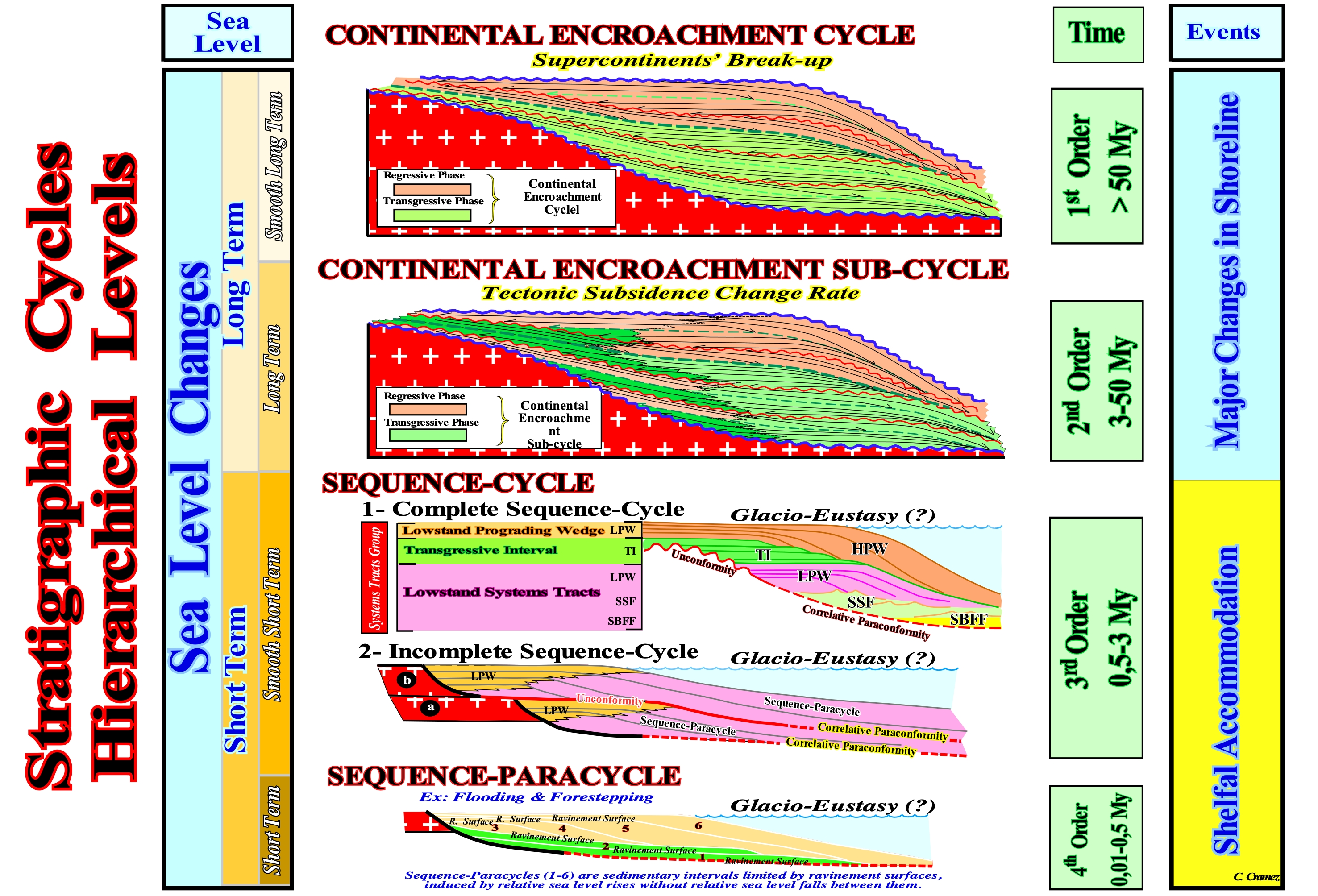
Figure 139- Hierarchy of the Stratigraphic Cycles according B.Duval, C. Cramez and P. Vail (1992): Continental Encroachment Cycles, Continental Encroachment Sub-Cycles, Sequence-Cycles and Sequence-Paracycles
Let's see some examples:

Figure 140- The Phanerozoic is formed by two continental encroachment cycles induced by two eustatic cycles of first order. The first continental encroachment cycle is commonly called Paleozoic, while the second cycle, the more recent, is called Meso-Cenozoic. The first continental encroachment cycle is the result of breakup of the Proto-Pangea supercontinent and agglutination of the continents, that such a breakup originated, to created the Pangea supercontinent. The last continental encroachment cycle (Meso-Cenozoic) is the result of breakup of the Pangaea supercontinent and agglutination of new continents that started, probably, in Late Cretaceous. Each of these continental encroachment cycles consists of two stratigraphic phases. The lower stratigraphic phase is the transgressive phase, whose geometry is retrogradational, that is to say, the sediments, which form it, thick continentward before pinchouting, more or less, abruptly. The upper regressive stratigraphic phase has progradational geometry, i.e., the sediments thick seaward before thinning out by downlapping. The transgressive phase of the Paleozoic continental encroachment cycle was induced by an eustatic rise that began in the Precambrian and reached its acme in the Ordovician / Silurian. The regressive phase is associated with an eustatic fall (do not confound with relative sea level fall) that began in Ordovician / Silurian and ended with the formation of the Pangaea. In post-Pangea eustatic cycle, the sea level rise responsible of the transgressive phase began with the breakup of the Pangea and ended the Cenomanian / Turonian, while the eustatic fall responsible of the regressive phase began in the Cenomanian / Turonian keep going nowadays. The boundaries between the transgressive and regressive phases correspond to major downlap surfaces with which the principal marine source-rocks area associated.

Figure 141- A continental encroachment cycle is formed by subcycles, bounded by unconformities and deposited in association with second order eustatic cycles, which duration varies between 3-5 millions and 50 million years. As illustrated in this figure, each continental encroachment subcycle is formed by a second order transgressive stratigraphic phase, which is covered by a regressive stage. The boundaries between these phases are minor downlap surfaces with which secondary marine-source rocks may be associated.
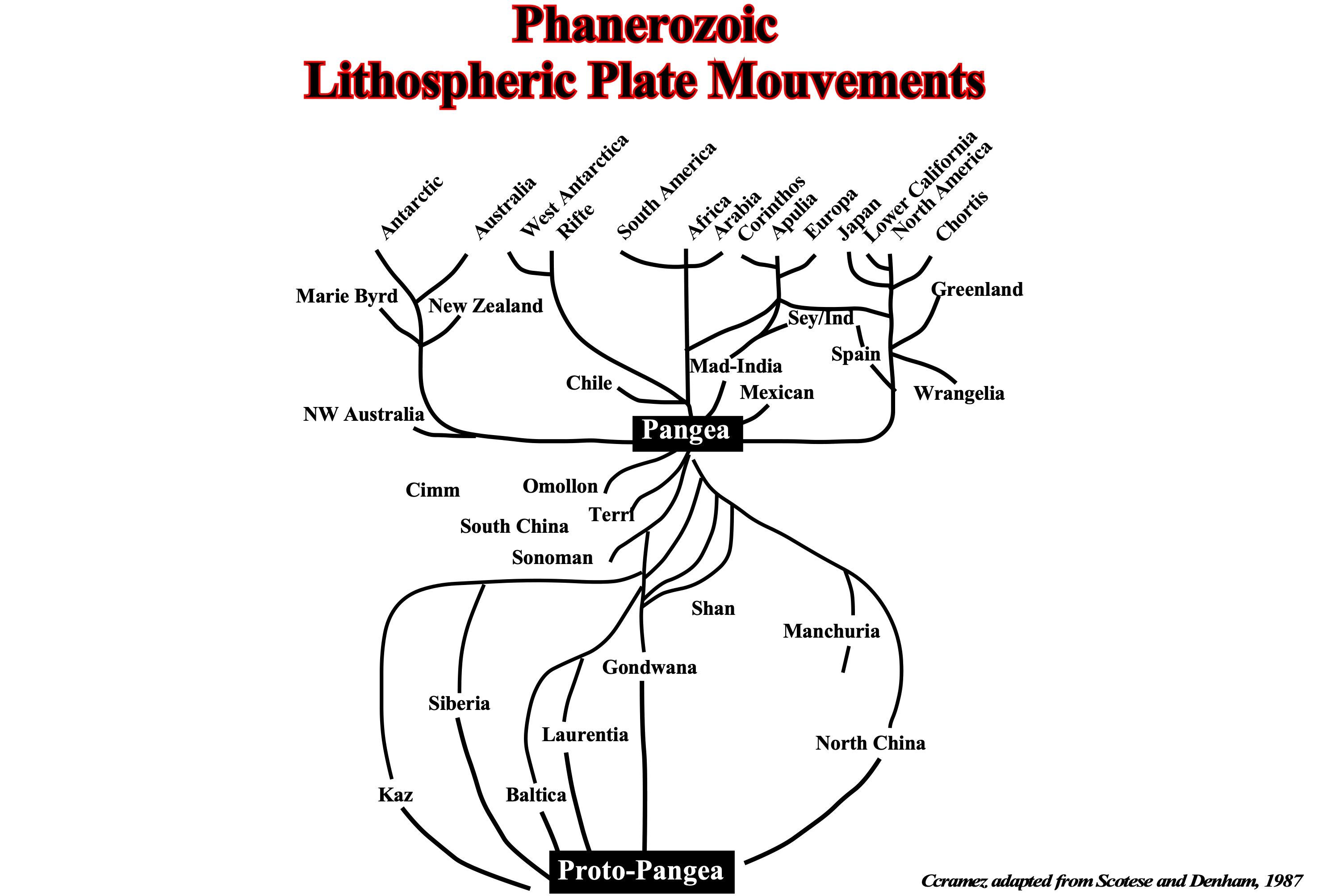
Figure 142- This figure illustrates the movement of the Paleozoic lithospheric plates (resulting from breakup of Proto-Pangea supercontinent or Rodhinia) and the post-Pangea lithospheric plates. After the breakup of the Proto-Pangea, the continents, supported by the lithospheric plates, began by moving away (spreading phase or expansion), to after reaching the maximum of dispersion, begin to approach each other until they collide and form a new supercontinent (Pangea) in Permo / Triassic. After the breakup of Pangaea, new lithosphere plates were individualized carrying with them continents. At the Cenomanian / Turonian, the continents reached the maximum spreading between them (end of transgressive stratigraphic phase). Then, the plates began to disappear along Benioff subduction zones (type-B subduction) and continents to approach each other to within a few million years to form a new supercontinent.
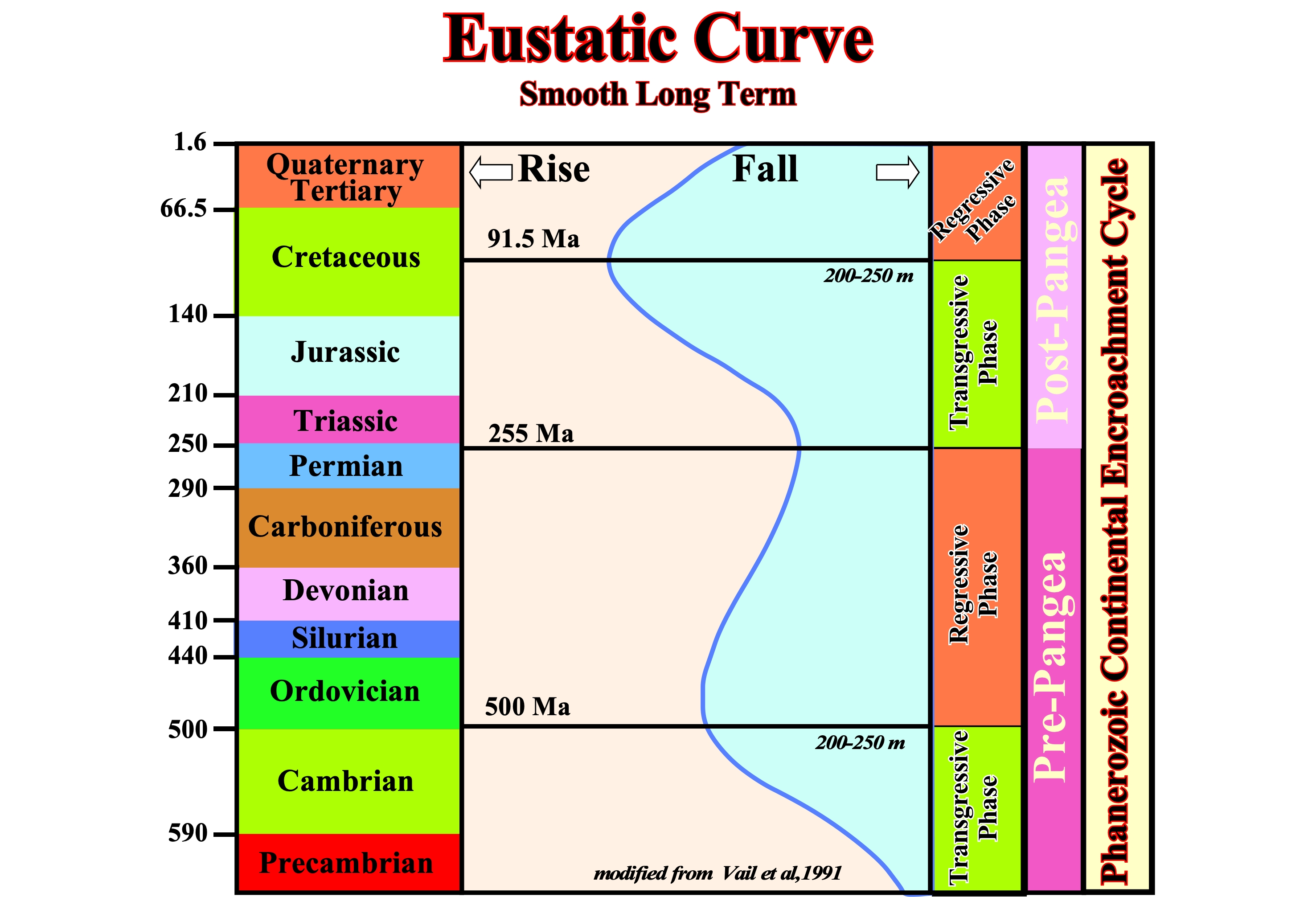
Figure 143- The eustatic curve here illustrated (smoothed long-term) displays two eustatic high, one in the Paleozoic (Cambrian / Ordovician) and other in Meso-Cenozoic (Cretaceous, Cenomanian / Turonian). These two climaxes of the eustatic curve correspond to geological epochs where the volume of ocean basins was minimal (many oceanic ridges), which for the same amount of water causes an eustatic rise. The conjecture that the amount of water in all its forms, is constant is followed by most geoscientist. As illustrated the two highest peaks of the curve eustatic separate the transgressive stratigraphic phase from the regressive phase, which corresponds to the moment when the extension of the continental shelf is maximum (when the depositional coastal breaks are far away, continentward, of shelf breaks).
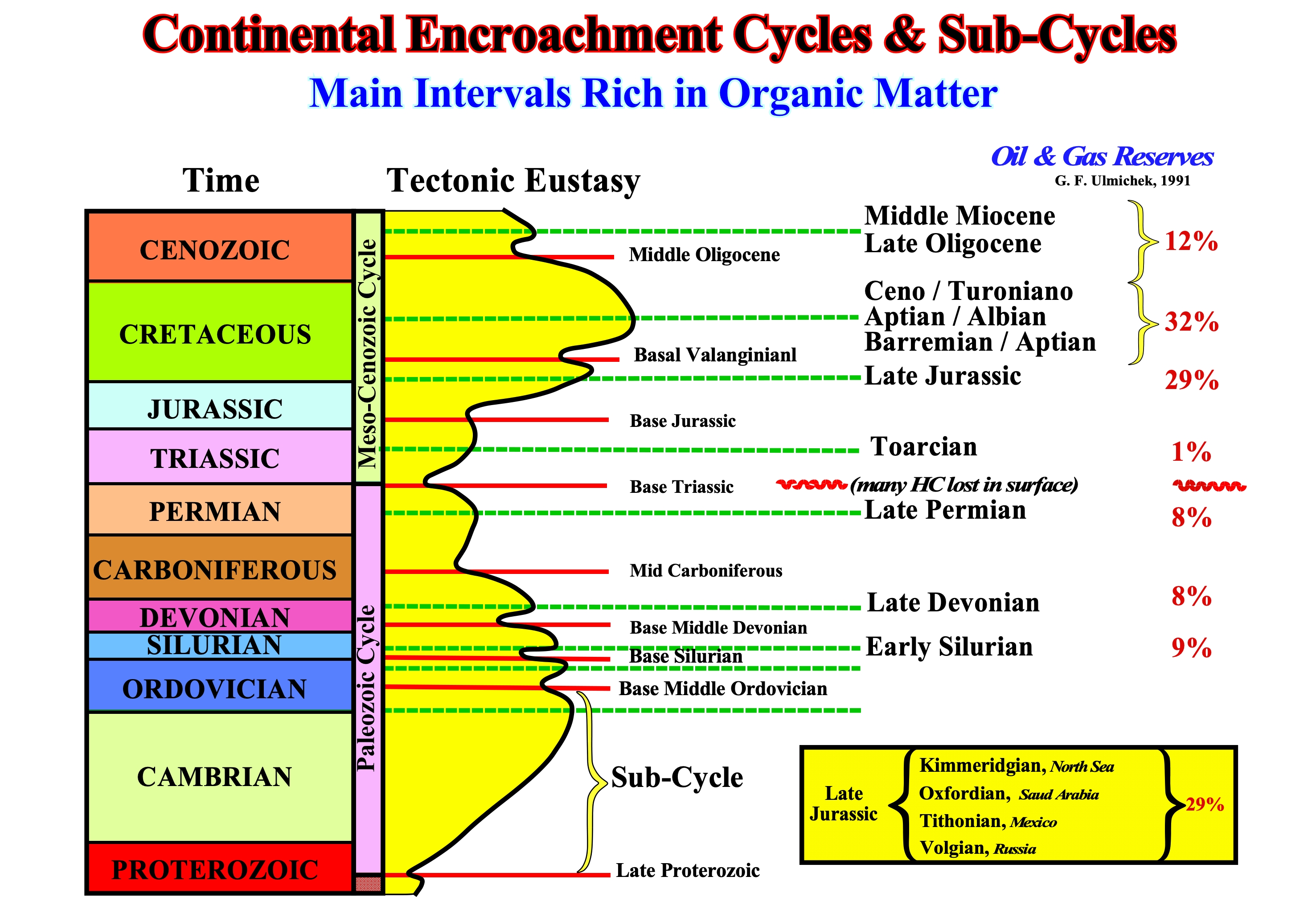
Figure 144- The unconformities are highlighted by the red lines as Late Proterozoic, whereas the downlap surfaces of the main continental encroachment subcycles are outlined by dashed lines green as, for instance, Late Devonian. From the oldest to the most recent, the ages of the downlap surfaces rich in organic matter (potential parent rocks) are : (i) Early Silurian, which generated ± 9% of oil and gas reserves ; (ii) Late Devonian (± 8%) ; (iii) Late Permian (± 8%) ; (iv) Toarcian (1%) ; (v) Late Jurassic (± 29%) ; (vi) Early Cretaceous (± 32%) and (vii) Oligo-Miocene (± 12%). Taking into account the lost of the hydrocarbons at the surface during Hercynian orogeny, it can be said that most hydrocarbons are generated by marine source-rocks associated with the downlap surfaces of the continental encroachment cycles. The Late Jurassic and Early Cretaceous Late source-rocks generated, practically, 60% of world reserves of oil and gas. One cannot say that the marine source-rocks associated with main Paleozoic (Ordovician / Silurian) downlap surfaces generated less hydrocarbons than the marine source-rocks associated with the Post-Pangea continental encroachment downlap surfaces, since there is between them the great erosional phase of the Hercynian orogeny. A large proportion of hydrocarbons generated by the Paleozoic source-rocks was lost at surface.
Question: What observe or identify, on seismic lines, intervals with characteristics of secondary source-rocks?
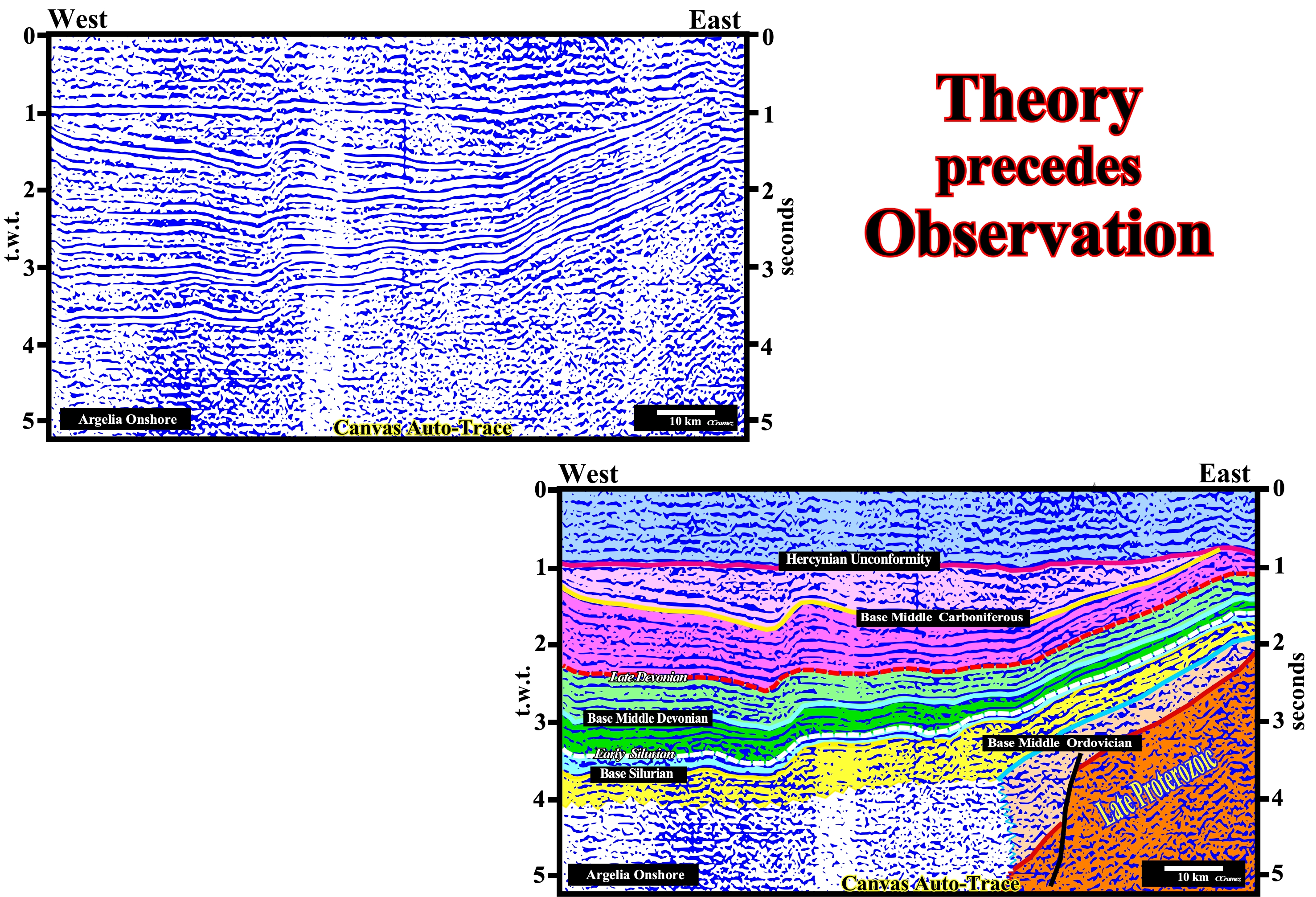
Figure 145- In this tentative geological interpretation of a regional seismic line of onshore Algeria, under the Hercynian unconformity, two downlap surfaces are, more or less, clearly visible : (i) The lower one is Early Silurian and (ii) The upper one is Late Devonian , as predicted in the previous figure. Theoretically, the organic-rich sediments associated with these two downlap surfaces are probably the best candidates for marine potential source-rocks.
Quewstion : How to find economical accumulations associated with non-structural traps ?
The theory says that the economically hydrocarbon accumulations are the result of the combination of lithological, favourable structural and hydrodynamic conditions. If one or more of these factors is unfavourable, the results are usually : A geological success but an economic failure. It is relatively rare, but not impossible, to have a pure hydrodynamic traps. However, it can be said that, practically, all giant oil fields have an important hydrodynamic component.
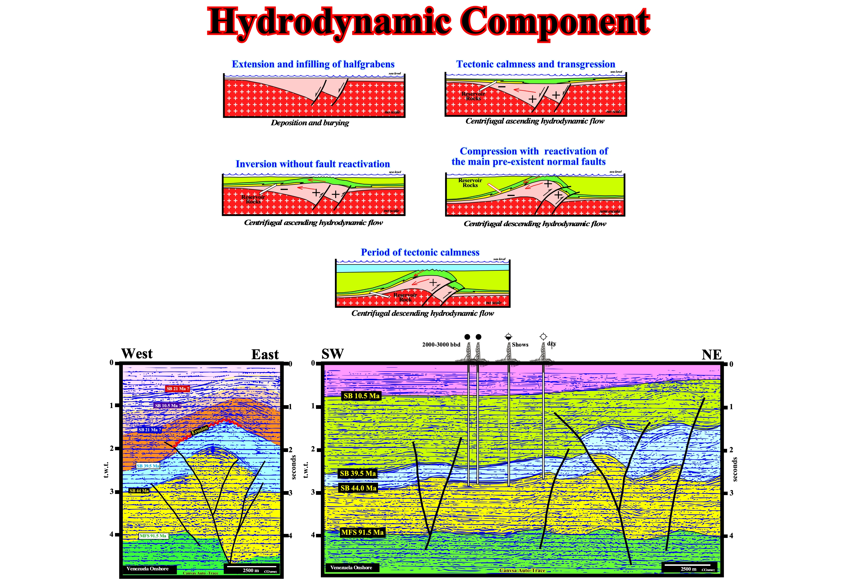
Figure 146- On top of this figure is illustrated the geological mechanism, that in back-arc basin, can produce hydrodynamic traps or enhance non-structural traps, since, by definition, in these basins there is almost always a significant tectonic inversion. This mechanism is made in five tectonic -sedimentary phase: (i) Extension and infilling of the halfgrabens, which means that during the lengthening (differential subsidence) of the back-arc rift-type basin area formed that were filled by sediments, locally, rich in organic matter ; (ii) Since the lengthening finished a sag phase (thermal subsidence) began with the deposition of transgressive sands (reservoir-rocks) that are quickly covered by shales (sealing-rocks) and developing an upward hydrodynamic flow (centrifugal), since water pressure is higher in depth ; (iii) Inversion without reactivation of normal faults of rift-type basins, which still allows a centrifugal ascending hydrodynamic flow centrifugal ; (iv) Shortening (compression) with reactivation of the main pre-existing normal faults and formation of anticline structure that transforms the centrifugal ascending hydrodynamic flow in a descending flow, which can create hydrodynamic traps, mainly, in transgressive retrogradational sands ; (vi) The shortening phase is followed by tectonic quiet phase, in which the deposited sediments fossilize the unconformity created by tectonic inversion. The seismic lines illustrate the structural traps on Venezuela onshore, which are, virtually, all dry (no trapped hydrocarbons), since the climax of tectonic inversion postdate the migration of hydrocarbons. However, the results of the exploration wells drilled on the seismic profile illustrated on the right strongly suggest the possibility of hydrodynamic traps or with a strong hydrodynamic component, since the well with hydrocarbons (economic accumulation) is located below in a structural low and that the reservoir-rocks are transgressive sands with a sharp retrogradational geometry.