This is the Home Page of the short course "Salt Tectonics". If you click on the interlinks (underlined text and bots), you can navigate and you will find a text and the majority of the plates shown during the course.
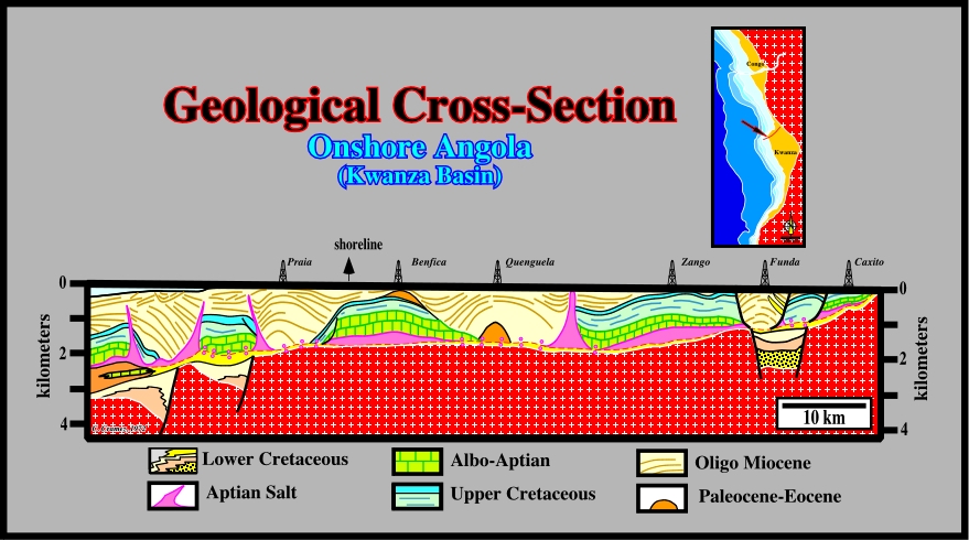
This geological cross-section was built with the well results (controlled by few seismic lines of 1960’s vintage). It illustrates what Total’s geoscientists labelled " Rafting Tectonics" (“Tectonique en Radeaux” in French), in Angola offshore. According to the Bally & Snelson (1980) basin classification, this offshore, corresponds to a stacking of several basin types (i) Basement (Precambrian granite-gneiss, Paleozoic folded belts, Karoo sediments, etc.), intercal colored in red with white crosses ; (ii) Upper Jurassic-Lower Cretaceous rift-type basins and (iii) a Meso-Cenozoic Atlantic-type Divergent margin. At the Aptian time, in the margin, two large salt salt depocenters were deposited. They were separated by a coastal arch, covered by a, relatively, thin salt interval. The eastern salt depocenter, known as Inner Kwanza Salt Sub-Basin, corresponds, roughly, to the Kwanza onshore. The western salt depocenter, known as Outer Kwanza Salt Sub-Basin corresponds, more or less, to the deep Kwanza offshore. The salt horizon (in pink on this cross-section) created a tectonic disharmony, which ios not an unconformity, since there is any significant relative sea level fall associated, ti.e., there is any erosion associated. Above the tectonic disharmony (more or less the bottom of the salt level or associated salt welds) the sediments are deformed, while below they are undeformed. The large majority of structures depicted in this Atlantic-type divergent margin are extensional (effective stress ellipsoid with σ1 vertical) and salt induced. Some of them, as we will see later, were explained by opposite hypotheses (maximum extension with a minimum salt reduction or minimum extension with a maximum salt reduction). The main problem is explaining the creation of space for rafting. Halokinesis is probably the preponderant mechanism. However, it cannot explain all structures, since translation of the overburden above a decollement surface (top salt or fault weld, i.e., above the tectonic disharmony) is, often, quite evident. Locally, compressional structures (effective stress ellipsoid with σ1 horizontal) are possible in association with reactivation of Pre-Pangea fracture zones.
The above tentative geological cross-section illustrates, clearly, how the knowledge of the basic principles on Salt Tectonics is indispensable to propose tentative interpretations difficult to falsify, i.e., scientific tentatives approaching the geologic reality of an area. Actually, rafting, translation, allochthonous salt sheets, salt rollers, faults welds, diapirs, salt expulsion basins and turbidite depositional systems are a priori key hypotheses in geological interpretation of seismic lines shot in geographic provinces with salt layers. Do not forget on the tentative geological interpretations of the seismic lines, Theory precedes Observation (K. Popper, 1934). If a geoscientist doesn't not know what is, for instance, a salt weld or rift-type basin, he can never recognize them on seismic lines or their "autotraces" (in this workshop, for confidentiality reasons, many of the original seismic lines are replaced by autotraces made automatically, using Canvas X Draw or hand-made, in which the most important and significant seismic reflectors were picked in continuity). By the same token, a geological or geophysical observation has a large range of meanings, depending on the geoscientist background. They range from observations made by naive inductive geoscientists (totally ignorant of the geological context and for who Observation precedes Theory) to observations made by rationalist geoscientists (who know what they are look for and for who Theory precedes Observation). For a rationalist or critic geoscientists there are not pure geological observations, i.e., there are no observations without an important theoretical component : all observations are interpretations of facts in the light of one or another theory, in other words, all observations are theory dependent. On this geological cross-section, based on tentative interpretations of seismic lines, the geoscientist in charge knew, a priori, the seismic lines were shot in a geographic province formed by the stacking of different sedimentary basins (rift-type basins pre-dating the breakup of the Gondwana lithosphere and an Atlantic-type divergent margin post-dating the breakup unconformity). The Atlantic-type margin comprises (i) a lower sub-aerial volcanic interval formed, mainly, by of lava-flows (SDRs), recognized, particularly, nearby the breakup zone and (ii) an upper clastic interval, in which, near the bottom, a thick potash-rich salt layer was deposited. The movements of the salt layer are responsible of the majority of the structures recognized on the seismic lines, that we are going to describe on this workshop. However, you should not confuse " Being " as, for instance, a salt expulsion basin or an allochthonous salt sheet with " Representing " (representation of "Being"), i.e., the seismic picture of a salt expulsion basin or allochthonous salt sheet.
Summing up : If a geoscientist knows the regional and global geological context of the West Africa Margin, as well as, the main salt tectonics geological models, he will interpret, in geological terms, the seismic lines of the area, easily, and he will recognize, without difficulty, the more likely potential petroleum systems (Magoon, L., & Dow, W.G., 1994), that is to say, the pods of active source rocks and all related oil and gas, including all essential elements and processes needed for oil and gas accumulations to exist.
click on the underlined text
by
Carlos Cramez