
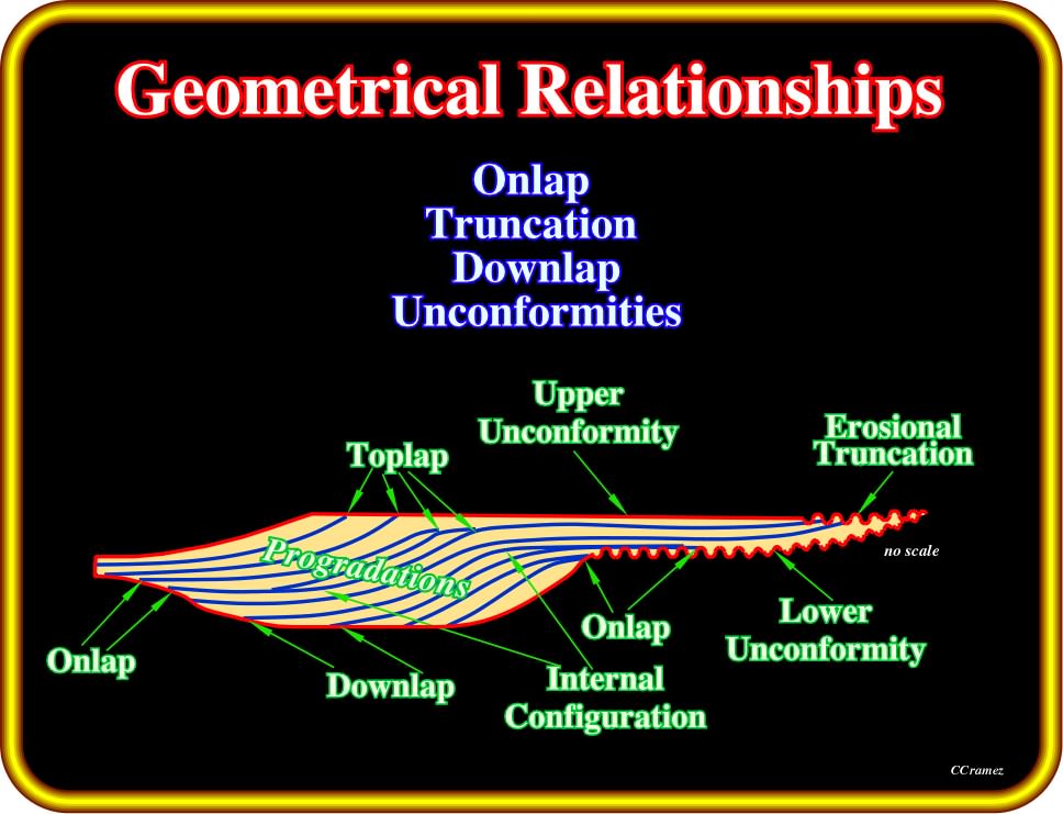
Plate 127- On the next pages, we will review the geometrical relationships (reflection terminations) associated with stratigraphic cycles and particularly with sequence cycles, i.e., stratigraphic cycles associated with 3rd order eustatic cycles, which are the building block of sequential stratigraphy. Each geometrical relationship (onlap, downlap, toplap, etc.) will be defined and illustrated on tentative interpretation of auto-traces of regional seismic line. We will try to explain its meaning in geological terms.
A base-discordant relation in which, initially (deposition time), horizontal strata terminate, progressively, against an, initially, inclined surface, or in which, initially, inclined strata terminate, progressively, up-dip against a surface of greater initial inclination.
Varieties of onlap are :
(i) Proximal onlap ;
(ii) Distal onlap ;
(iii) Coastal onlap ;
(iv) Marine onlap ;
(v) Apparent onlap ;
(vi) Non-marine onlap;
(vii) True onlap ;
(viii) Tilted onlap (apparent downlap).
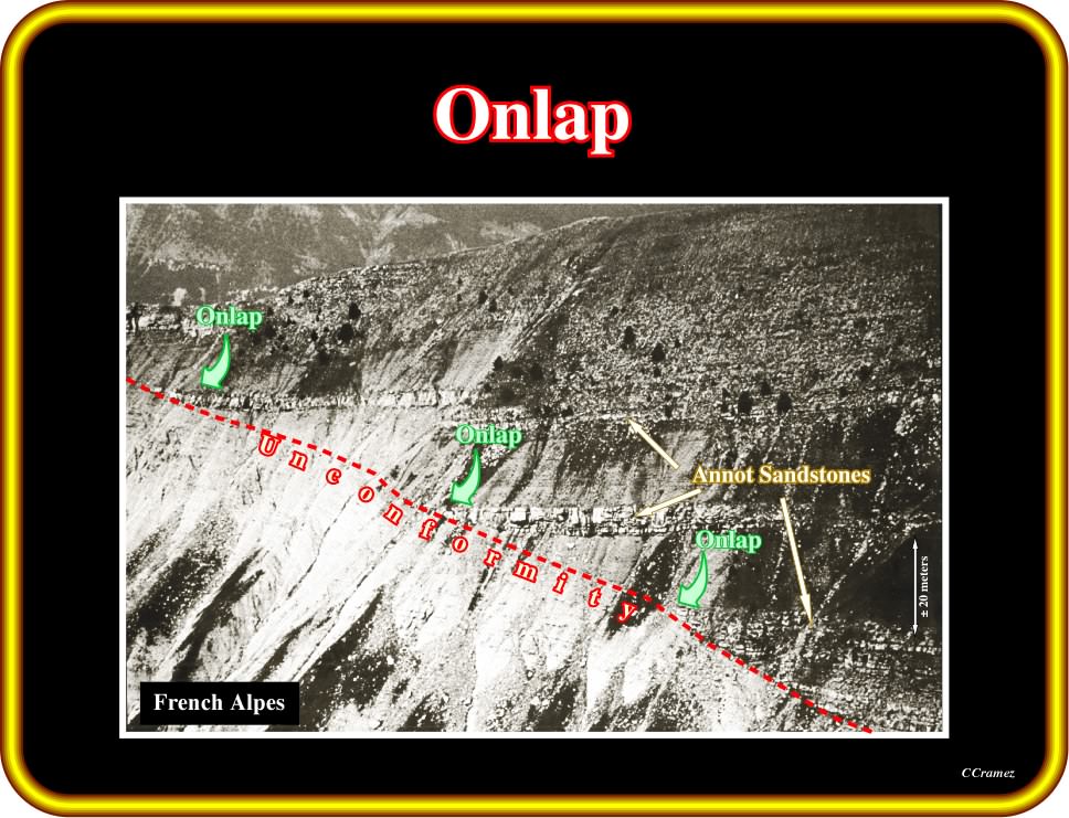
Plate 128- The Annot sandstones are deep-water turbidite lobes, which onlap a major unconformity (erosional surface induced by a significant relative sea level fall). The unconformity (in this case a marine erosional surface) is fossilized by the onlapping of turbidite depositional systems. In this particular example (turbidite deposition), the onlap relations do not correspond to a relative sea level rise, but to the stacking of successive turbidite lobes induced by gravity currents, which (according P. Vail) are, generally, formed during lowstand geological situations (sea level below the shelf break).
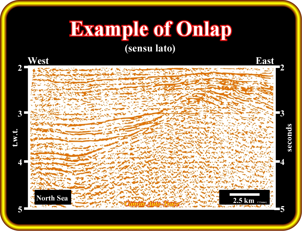
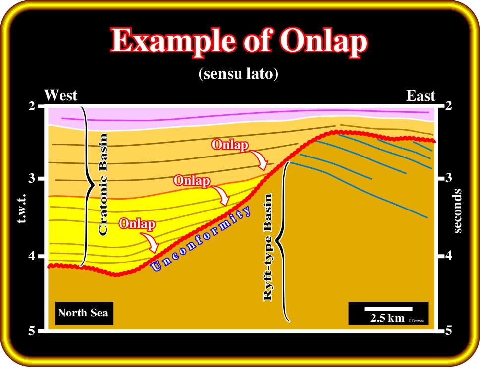
Plate 129- The North Sea is composed by the stacking of three different sedimentary basins. From bottom to top geoscientists, generally, have no major difficulties recognizing : (i) a Paleozoic fold belt (not illustrated on this tentative interpretation), often considered as a petroleum basement ; (ii) Mesozoic rift-type basins and (iii) a Cenozoic cratonic basin. On this geological tentative interpretation of an auto-trace of a North Sea seismic line, interpreters using reflection terminations of the Cenozoic sediments, consider that an onlap seismic surface (not emphasized by seismic reflectors, but by reflection terminations) exists between the Mesozoic and Cenozoic intervals. Onlap, generally, represents a marine (or lacustrine) transgression (or regression) over old sediments, i.e., a relative sea level rise. Onlapping means aggradation, that is to say, build up to an high level by depositing sediments. Different types of onlap can be recognized either on the ground or on the seismic lines.
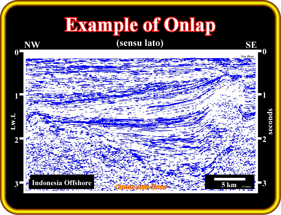
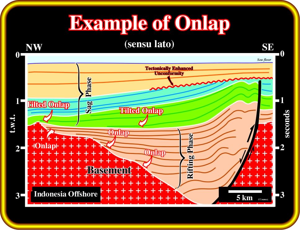
Plate 130- The pristine geometrical relationships (deposition time) are, often, deformed by later tectonic regimes, as illustrated on this tentative interpretation of an auto-trace of a seismic line of a SE Asia backarc basin. A compressional tectonic regime took place after the rifting phase of the backarc basin. The old normal fault (in black) bordering the rift-type basin (rifting phase of the backarc basin) was reactivated as reverse fault tilting (uplifting) the original geometrical relationships between the seismic markers. When the tilting is strong enough, onlapping can, apparently, become another geometrical relationship, as it is the case in the green seismic interval (apparent downlap). Note in the upper part of the interpretation (sag phase of the back-arc basin) a local tectonically enhanced unconformity (angular unconformity). In this particular case, it is quite easy to recognize that such an unconformity is just an eustatic unconformity, mainly induced by a relative sea level fall, locally, enhanced by the tectonics.
(i) Proximal Onlap
A proximal onlap is an onlap in the direction of the source of clastic supply (generally looking landward).
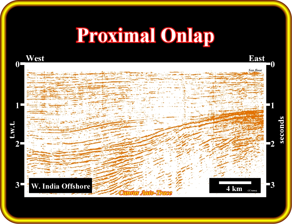
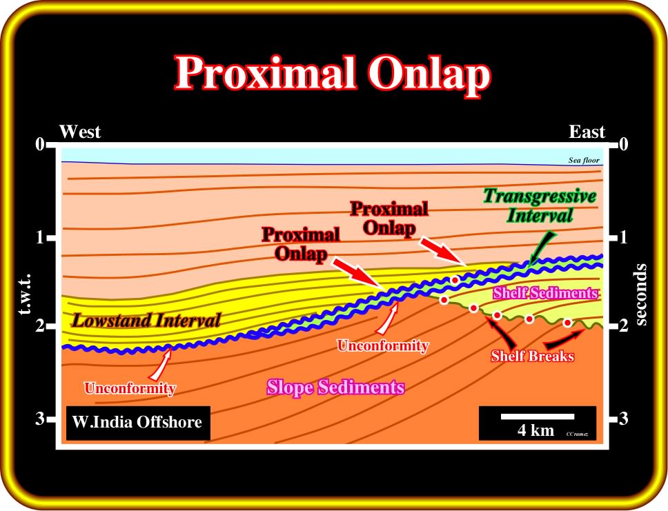
Plate 131 - On this tentative interpretation of an auto-trace of a seismic line from West India offshore, the source of clastic supply is located eastward. The red arrows underlie proximal onlaps, which can be coastal or marine, depending whether they are associated with marine sediments (seaward of the shelf break) or shallow marine (landward of depositional coastal break). On this tentative interpretation (Atlantic-type divergent margin), the onlaps are coastal. They are associated with the aggradation of a lowstand regressive interval (lowstand prograding wedge, LPW), which fossilize an unconformity (seismic onlap surface) induced by a relative sea level fall, which took place between the transgressive interval (green, between two unconformities) and the regressive lowstand interval (in yellow). Note the evolution of the shelf break, i.e., the progradation of the shelf break during the lowermost regressive interval.
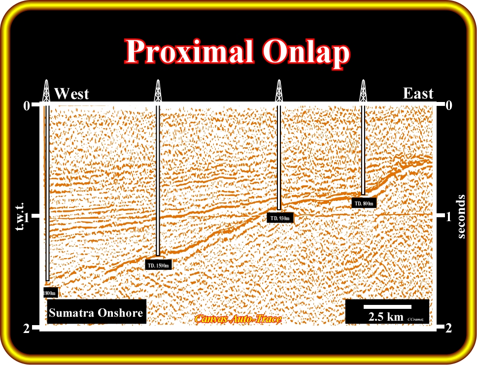
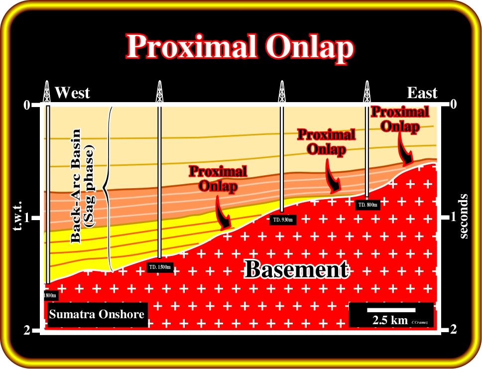
Plate 132 - On this tentative interpretation of an auto-trace of a seismic line from Sumatra onshore (Cenozoic backarc basin induced by a Benioff or B-type subduction zone), the proximal onlaps of the seismic reflectors (upper seismic packages of the sag phase of the backarc basin) are, easily, recognized. Taking into account the proposed geological interpretation, it is quite evident that the more likely source of clastic sedimentary particles is the basement, which outcrops few kilometers eastward. Theoretically, the onlap seismic surface, between the sag sediment terminations and the basement (granite-gneiss or Paleozoic fold belt), is created by the coastal aggradation of the regressive intervals of the backarc basin. Deep-water turbidite depositional systems were deposited during relative sea level falls (unconformities) bounding the different intervals, generally, in lowstand geological situation (sea level below the shelf break).
(ii) Distal Onlap
A distal onlap is an onlap in the direction away from the source of clastic supply (generally, looking seaward).

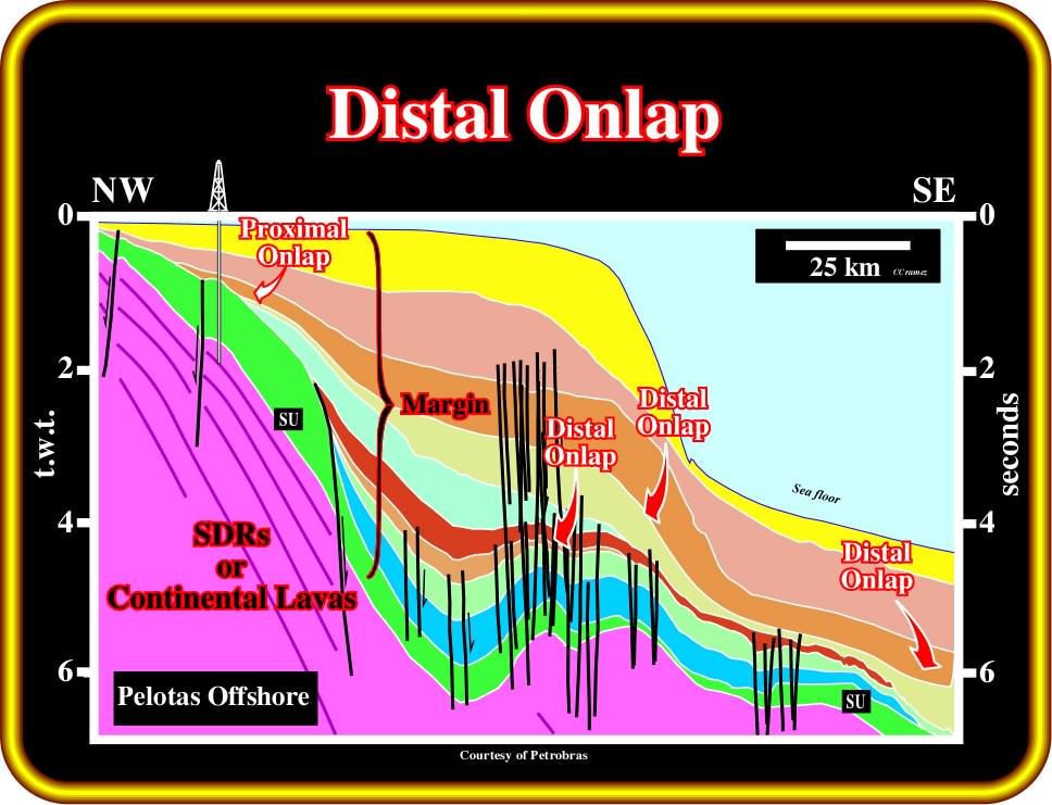
Plate 133 - Distal onlaps are, easily, recognized on regional seismic lines of the Brazil offshore (post-Pangea Atlantic-type divergent margin). In this margin, as depicted on this tentative interpretation of an auto-trace of a regional seismic line of Pelotas geographic basin, the petroleum basement is, mainly, composed by Mesozoic sub-aerial lava-flows, which, locally, can overly Precambrian and Paleozoic sediments. The most likely source of clastic sedimentary particles are the rocks of the infrastructure (Precambrian or Paleozoic rocks) and the post-breakup lava-flows. Both outcrop westward and were corroborated by drilling. Distal onlaps of the Atlantic-type margin, as stressed above, are the reflection terminations in the direction away of the source of clastic supply (southeastward terminations). The unconformity (SU), on the top of the lava-flows (seaward dipping reflectors), is not the breakup unconformity. It is, more or less, 10 My younger than the breakup unconformity (BUU), which is not visible on this tentative interpretation. Take into account the pitfall induced by the sharp change in water depth. All reflectors below the present shelf break (slope and abyssal plain) are, strongly, pull-down. On a depth version of the line, the majority of these reflectors dips landward, which enhances the distal position of the onlapping.
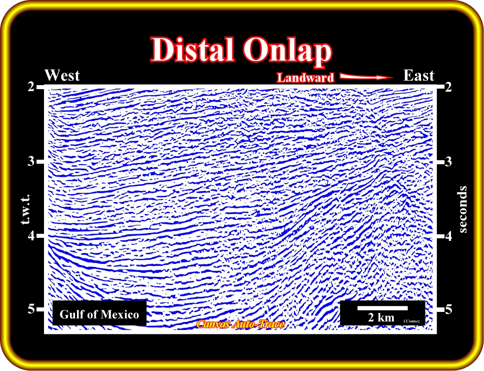
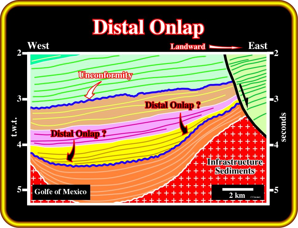
Plate 134 - On this tentative interpretation of an auto-trace of a seismic line of the deep-water Gulf of Mexico (Cenozoic Mediterranean-type basin), reflection terminations and seismic surfaces are quite easy to recognize. In spite of the fact that the source of clastic sedimentary particles is located eastward (landward), is quite difficult to differentiate proximal from distal onlap. Due to salt flowage (halokinesis) and, particularly, due to the salt evacuation, salt expulsion basins (American geoscientists call them mini-basins) control the gravity currents, which can take fancy trajectories. In a salt expulsion basin, a distal onlap does not necessarily mean that the onlap is in the direction (same sense) of the major source of clastic supply. In deep-water salt expulsion environments, the direction of the source of clastic supply does not necessary corresponds to the regional direction of the terrigeneous transportation. On this tentative interpretation, the interval named infrastructure sediments comprise the salt layer and infra-salt sediments, i.e., all sediments below the overburden (strata younger than the salt substratum)
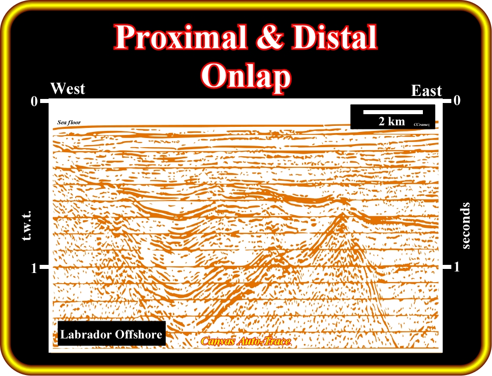
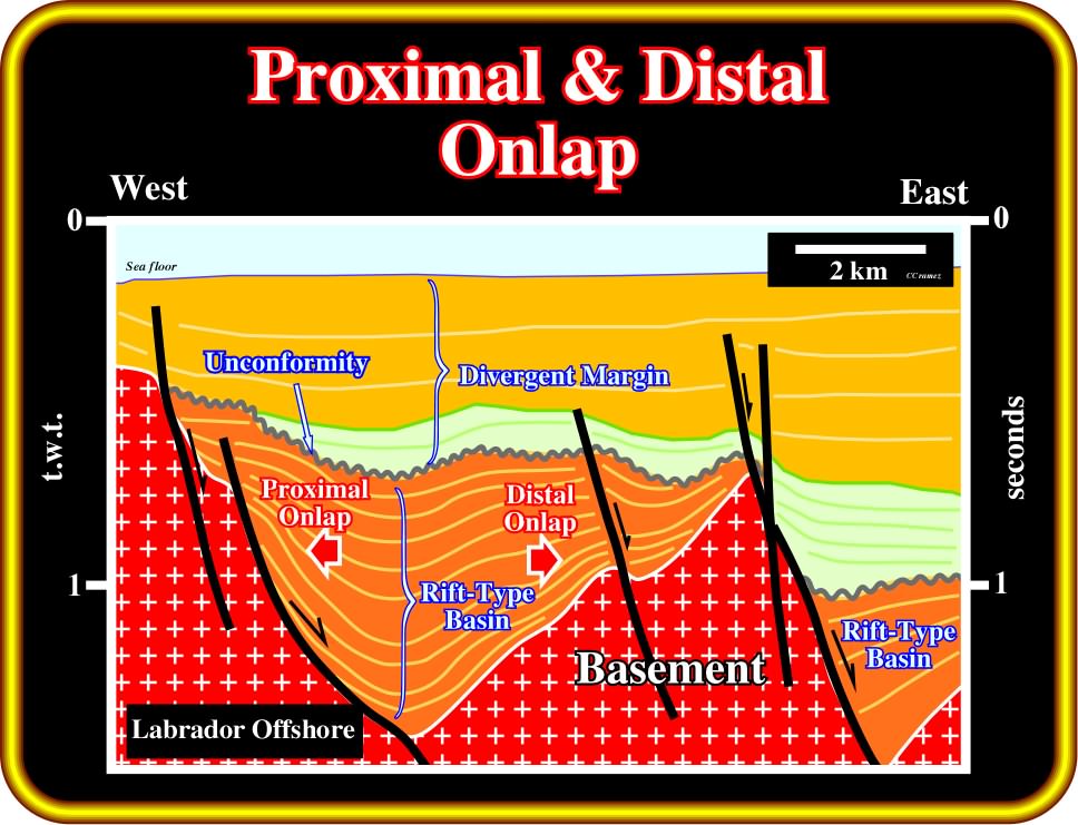
Plate 135 - On this tentative interpretation of an auto-trace of a seismic line of the Labrador offshore, the geometry of the rift-type basin is, often, that of a half-graben. The infilling sediments thick landward toward the normal fault planes (the subsidence is differential). Such a feature, strongly, suggests the direction of the source of clastic supply is from west to east. Proximal onlaps look westward (landward), while distal onlaps look eastward (seaward). The onlaps are non-marine. The predominant geological environment in rift-type basins is alluvial or fluvial, in which parent materials are deposited by moving water bodies such as rivers and streams. Under certain climate and geological conditions, lacustrine environments can develop and organic rich lacustrine shale can be deposited forming potential source-rock (organic matter type I).
(iii) Coastal Onlap
A coastal onlap is the progressive landward onlap of the coastal deposits in a given stratigraphic unit.
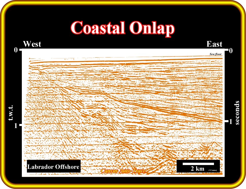
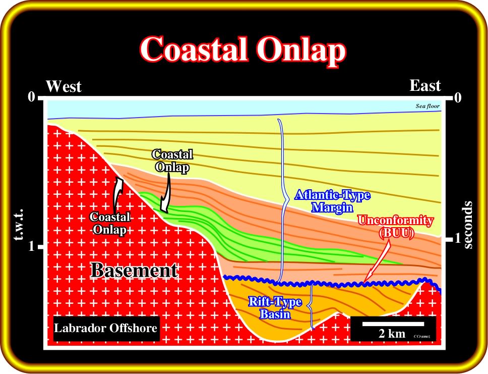
Plate 136 - The offshore of Labrador corresponds to a Cenozoic Atlantic-type divergent margin, which overlies Mesozoic rift-type basins, i.e., half-grabens which have lengthened the lithosphere during the rifting phase (before breakup and subsequently oceanization). On this tentative interpretation of an auto-trace of a regional seismic line of this area, the green interval represents a transgressive sedimentary package of the margin developed during a relative sea level rise. In this interval, the coastal onlaps are quite evident. The coastal aggradation (vertical component of coastal onlap) of this transgressive interval is around 400 milliseconds (t.w.t.) and the coastal encroachment (horizontal component of the coastal onlap) is, roughly, 4000 meters. For a given stratigraphic unit, the knowledge of the coastal aggradation and coastal encroachment allows prediction of the most likely topography of the underlying unconformity on which the unit transgressed. The breakup unconformity (BUU) between the rift-type basins and the Atlantic-type divergent margin marks a sharp change in environmental conditions. Above the BUU the environment is, mainly, marine, while below, it is mainly non-marine (lacustrine when the internal configuration is more or less parallel).
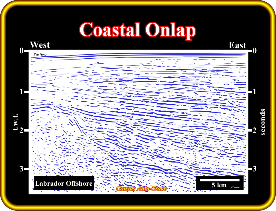
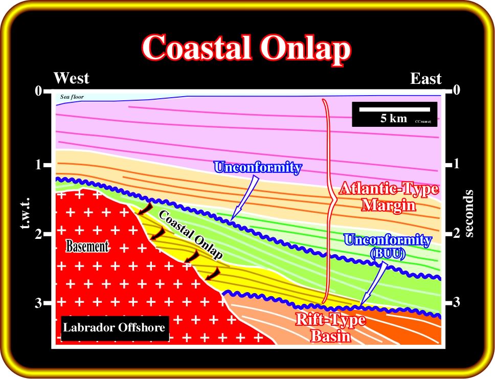
Plate 137 - This tentative interpretation of an auto-trace of a seismic line, located not very far from the line interpreted on the previous plate (Plate 136), illustrates coastal onlaps in a transgressive interval (yellow), which are, easily, recognized by its backstepping geometry. At each relative sea level rise, the depositional coastal break is displaced landward. Then, during a more or less standstill of sea level, the depositional coastal break is, progressively, displaced seaward as sedimentation takes place. However, it never reaches the position of the last depositional coastal break of the previous para-sequence (see later). A new relative sea level rise, again, displaces the depositional coastal break landward, and so on. This depositional mechanism is responsible of the backstepping geometry of the transgressive deposits, which, in fact correspond to a set of, progressively, smaller regressive deposits. In a transgressive interval, each para-cycle sequence or para-sequence (without relative sea level fall between them) has a progradational (forestepping) or regressive geometry as indicated by internal configuration, which quite often is under the seismic resolution, as it is the case here. However, when such intervals are drilled and cored, a typical progradational internal configuration is, always, visible.
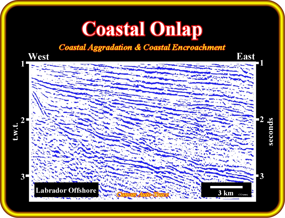
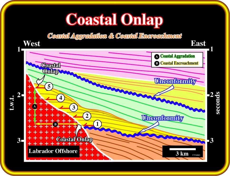
Plate 138 - This tentative interpretation of an auto-trace of seismic line of Labrador offshore depicts a coastal aggradation (A), i.e., the vertical component of the coastal onlap of a regressive interval (green) and coastal encroachment (B), that is to say, the horizontal component. Coastal encroachment is measured in kilometers, while the coastal aggradation is measured in milliseconds (two way time). A quickly time/depth conversion of the coastal aggradation, as, we will see later, gives the total relative sea level rise. Knowing the coastal aggradation (in meters or kilometers) and coastal encroachment, it is possible to get an idea of the morphology of the basement over which the sediments transgressed. A high coastal encroachment coupled with a low aggradation characterizes a flat morphology of the underlying unconformity (eventually basement), while a relative high aggradation and a small encroachment characterizes a steep morphology. In the last case, the backstepping geometry of the transgressive interval is quite sharp, since its thickness increase landward developing condensed stratigraphic sections in the distal part of the shelf (starved conditions).
(iv) Marine Onlap
Marine onlap is the onlap of marine strata, primarily. deep marine (deposited seaward of the shelf break) in nature.
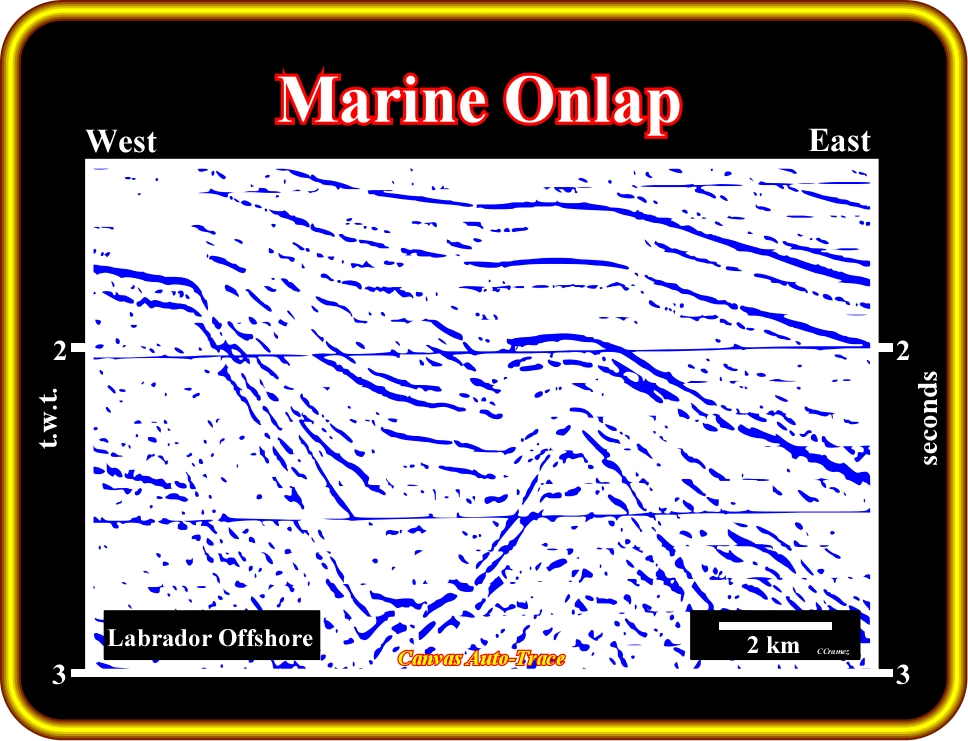
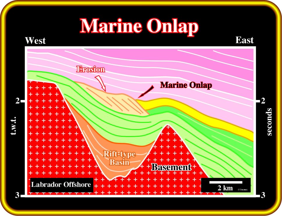
Plate 139 - On this tentative interpretation, certain geoscientists have considered the onlap of the yellow interval as a marine onlap. Others think that it is rather a coastal onlap than a marine onlap. In the central part of this auto-trace interpretation, it is easy to recognize a lowstand regressive interval, bounded above by an erosional surface. The upper part of the progradations, forming the regressive interval, were, partially, eroded. At the time of erosion, i.e., at the end of the regressive interval, the basin did not have a shelf. The depositional coastal break (more or less the shoreline) was coincident with the shelf break. Following a small relative sea level fall, the coastal deposits were, slightly, shifted seaward and basinward. The onlap of the yellow interval must be considered as a coastal onlap. Marine onlaps, as show in next plate, occur when the basin has a shelf (coastal break and shelf break not coincident) or when the relative sea level fall is big enough to create a change of environment of the depositional systems.
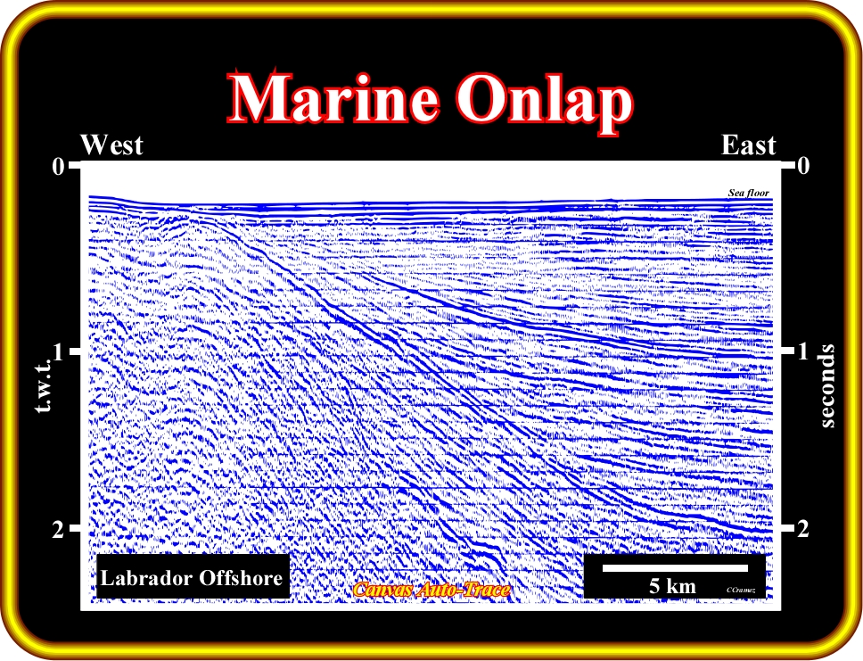
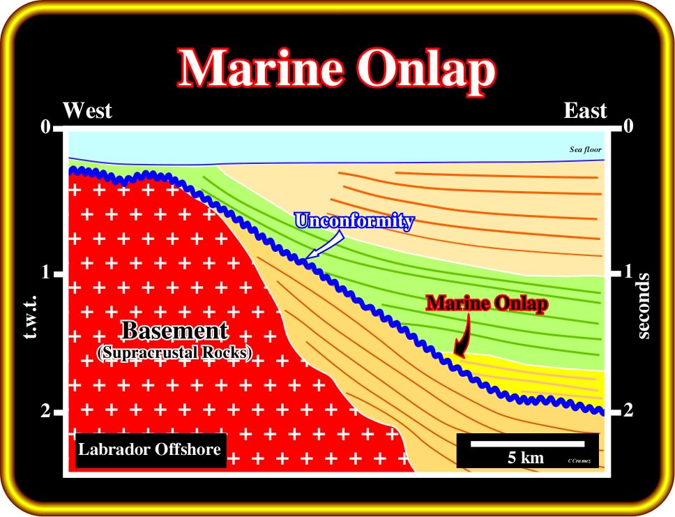
Plate 140 - On this tentative interpretation of an auto-trace of a regional line of the Labrador offshore (parallel to the direction of the source of clastic supply), the turbidite depositional systems of a basin floor fan interval (yellow package) onlaps (marine onlap) on a major unconformity (in blue), which seems to have been induced by an eastward tilting of the basin. In coastal deposits one could speak of marine aggradation and marine encroachment. However, traditionally, geoscientists keep aggradation and encroachment to express the vertical and horizontal components of coastal onlap. Marine onlap implies a significant depositional water depth. In coastal onlap, the water depth is, practically, zero. The basement is, mainly, composed by Precambrian supra-crustal rocks. The majority of the reflectors visible in the basement (not indicated in this tentative) are seismic artifacts, mainly, peg-legs. The uppermost reflectors are truncated, which means that the sea floor corresponds to an erosional surface, which geoscientists explain as a consequence of the isostatic rebound following the recent deglaciation (uncovering of glaciated land because of melting or sublimation of glaciers). The local landward increasing of the water depth is explained by the scouring the icebergs in their trajectory toward warm waters.
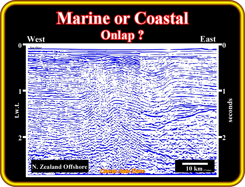
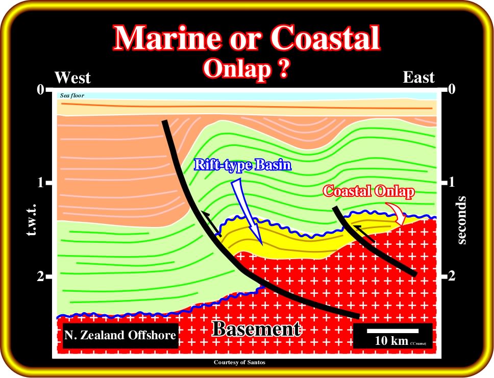
Plate 141 - On this tentative interpretation of an auto-trace of regional line of New Zealand offshore, compressional structures are paramount. These structures seem to have been developed by a significant tectonic inversion. In fact, it is quite possible that the old normal faults, developed during the rifting phase (extensional phase), were later, during a compressional tectonic regime, reactivated as reverse faults. If such a tectonic interpretation is not refuted by additional data, the onlap recognized on the yellow seismic interval is coastal (or non-marine) rather than marine. On this tectonic interpretation, the yellow interval is interpreted as the infilling of a rift-type basin, which are, generally, infilled by non-marine sediments. However, it is evident that the auto-trace can be interpreted in a differently way, as illustrated on the next plate.
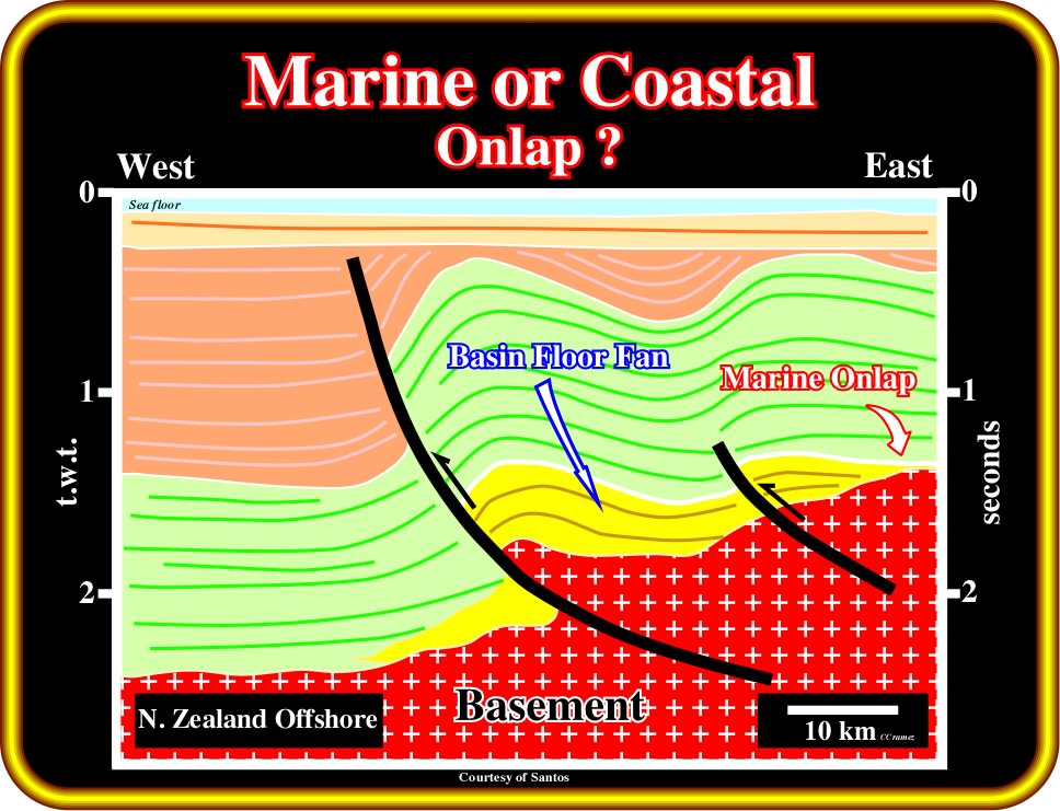
Plate 142 - In an alternative interpretation of the previous auto-trace, the yellow interval is interpreted not as a rift-type basin, but as a marine interval, likely a deep-water turbidite package deposited over a basement. If such a hypothesis is not refuted, the geometrical relationships between the yellow strata and the basement must be interpreted as marine onlap. This example, clearly, indicates that seismic interpretation cannot be done in isolation. It is, strongly, dependent of the regional and global geological settings and the geological knowledge of the interpreter. Geoscientists and ,particularly seismic interpreters, should never forget that there are no true interpretations. All tentative seismic interpretations will be, sooner or later, refuted by new geological data. A seismic interpretation can never be verified. It can only be validated or corroborated. Geoscientists progress by trial and errors, which means that seismic data must be interpreted several times using different priori hypothesis (observation is dependent of the theory assumed by the observer).
to continue press
