
V- Offshore Iberian Peninsula(cont.)
The topographic map of onshore Iberia underlines the trace of old fracture zones, striking NE-SW and N-S, which likely controlled the breakup of the Pangea and subsequent sea-floor spreading.
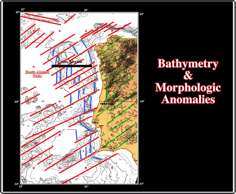
The bathymetry seems to corroborates the conjectures that the N-S lineations could be the surface expression of rifting faults, and the NE-SW are linked with the old transform faults, which seem to follow the Pangea fracture zones.
The interval velocity cross-section, based on a regional seismic line, corroborates (but not validate) the preceding conjectures, as illustrated below.
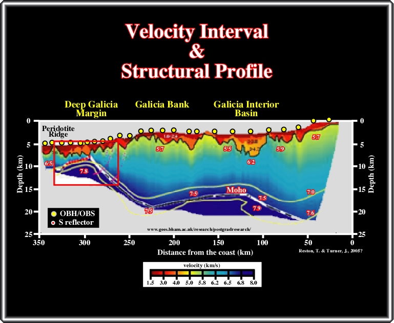
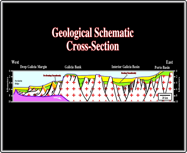
This velocity interval profile in north offshore of Iberia (Galicia Interior Basin, Galicia bank, Deep Galicia Margin) suggests the Moho discontinuity surface is relatively shallow ( ± 5 km below sea floor in Deep Galicia Margin and around 10-15 km in Galicia Basin). Conversely, pre-rifting and rift-type basin sediments, with velocity interval lower than 5 km/s are well predicted all along of the profile. On the western end, a peridotite ridge marks the onset of the oceanic crust. The boundary between the continental and volcanic crust (subaerial or oceanic) can be observed on a seismic lines located on the left end of the profile (small red rectangle).
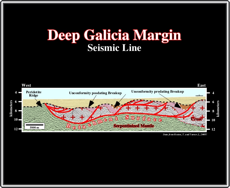
This seismic line clearly suggests that a lengthened continental crust lies over the upper mantle, which outcrops in the western end. The limit between the continental crust and the upper mantle, that is to say, the Moho discontinuity is here underlined by a detachment or décollement surface. Four major intervals can be differentiated in the continental crust: (i) a substratum, probably granite-gneiss, (ii) Paleozoic pre-rifting sediments, (iii) Mesozoic rift-type sediments and (iv) Ceno-Mesozoic post rifting sediments. The fault geometry, the morphology of the pre-rifting and the unconformities associated with the breakup, as well as the particular filling of the rift-type basins are the key elements to locate the COB. By the same token, they may explain why the SDRs are not evident on this offshore, which has been considered, by certain geologists, as a typical no volcanic margin.
Let’s see a parallel seismic line.
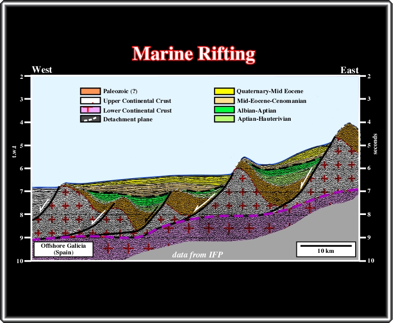
The detachment surface, the pre-rift (bottom of green seismic interval) and break-up unconformity (in black) are obvious. The rift-type basins are starved. They are partially filled mainly by deep-water sediments. Indeed, as suggested by the rifting escarpments, the facies and environment of the rift-type sediments, it is plausible that during rifting all, or part, of what became the west Iberia was under high water depth. In such a hypothesis, when to breakup took place, the basaltic material could not flow toward the continent creating SDRs, since under water it is frozen creating what we normally dub oceanic crust.
Let’s now take a look eastward of this line, i.e. between the deep Galicia margin and the Galicia Bank.
A regional schematic cross-section between Deep Galica Margin and Porto Basin can be depicted as above, in which is hypothesized the onset of a subduction of the oceanic crust under the continental crust (Galicia Bank - Porto Basin), as proposed several years ago by Ribeiro (2002, pp. 209-210). Indeed, the downward flexure of the lithosphere throwing the upper surface of the plate (continental crust between Galicia Bank and Deep Galicia margin) into tension created a local extensional tectonic regime, which could be the responsible for the detachment surface and reactivation and deformation of pre-existing normal rifting faults.
Using the bathymetric map and the lineations interpretation of Iberia offshore, one can propose a limit between the continental and volcanic crust (COB) as depicted below.
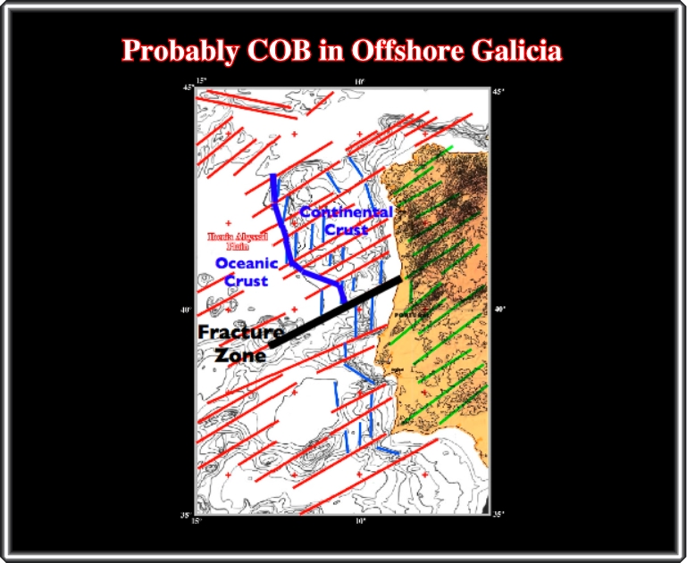
The southern limit of such a conjecture is a major fracture zone, which suggested by the bathymetry and corroborated by geologic and seismic data. In fact, southward of this fracture zone, the rift-type basins are filled by non-marine sediments and the evaporites, probably rich in potash, are found at the base of the margin. On the other hand, southward of this fracture zone, a regional compressional tectonic regime, probably associated with Benioff-subduction zone, is quite evident, as shown next.
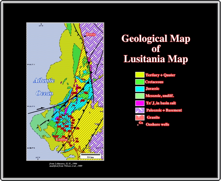
A quick look at this geological map points out that the Lusitania basin has been inverted. In reality, Jurassic sediments, that is to say, the oldest sediments outcrop in the central and topographic higher parts of the basin, while younger Cretaceous sediments outcrop in the border and lower areas. The tectonic inversion, which age is quite recent, is not refuted by seismic data.
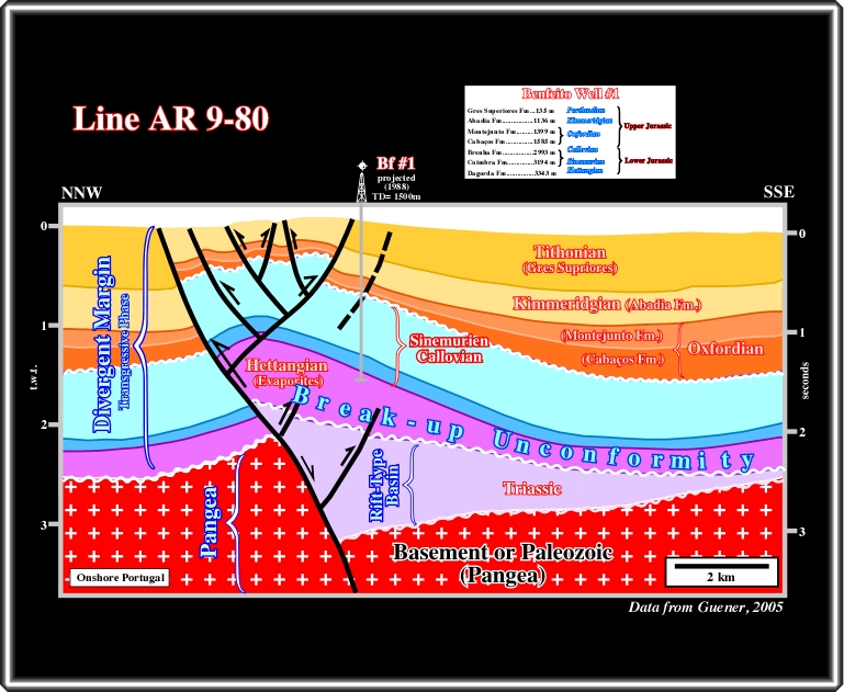
Taking into account the discorformities and thickness variations induced by salt tectonics, chiefly by compensatory subsidence, which has been systematically often ignored by field geologists, the rift-type basins and overlying margin sediments have been shortened, probably since Upper Miocene-Pliocene. The shortening was made mainly by buckling and reactivation, in reverse movement, of the pre-existent normal fault bordering the rift type-basins, as picture on this seismic line. Such a tectonic inversion is also corroborated by the seismic lines of the offshore, particularly in Alentejo Basin, where the sediments have been strongly shortened.
to continue press
next
![]()
Send E-mail to carloscramez@gmail.com or to carlos.cramez@bluewin.ch with questions or comments about this conference.
Copyright © 2006 CCramez
Last modification: August, 2014