IV- Refutation of Total's Hypothesis(cont.)
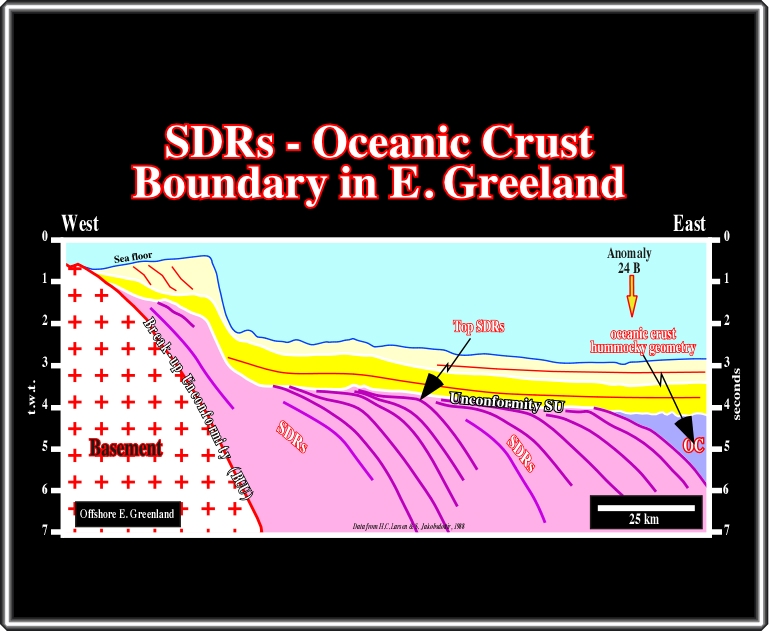
Let’s jump to North Atlantic (offshore Faeroe-Shetland), where the limit between the continental and subaerial crust is well visible, as well as the limit between the subaerial and oceanic crust, as illustrated in the schematic cross-section below.
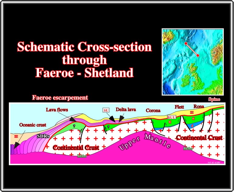
Where several rift-type basins (some are inverted) were recognized in the continental crust, below the breakup unconformity (BUU) and delta lavas along the SU unconformity (top of the lava-flows). The interpretation of the distal seismic line, on which the cross-section was based, is illustrated below:
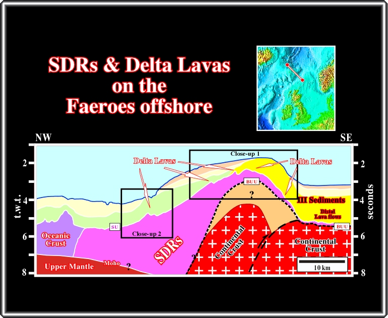
On this line, from East to West, under Tertiary deep-water sediments, it is easy to recognize: (i) the continental crust, (ii) an inverted rift-type basin, (iii) the break-up (BUU) unconformity, (iv) the SDRs (folded and thinning continentward), (v) the SU unconformity with delta-lavas and (vi) the oceanic crust. Certainly, delta-lavas, unambiguously, volcanic structures (frozen lava) formed when lava-flows come into an aquatic environment (lake, sea, etc.,) are unmistakably recognized along the SU unconformity, as fully illustrated on the next close-ups.
On this seismic line, naive inductive seismic interpreters (those refuting that “Theory precedes Observation) never identify SDRs and delta lavas. However, those knowing that SDRs thick and dip seaward in the direction of the spreading centres (sheeted dikes) and that volcanic material is frozen (cannot flow) under water, without major difficulty interpret it as shown above.
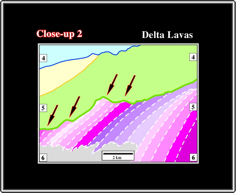
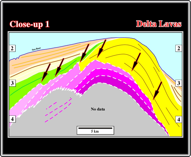
This close-up is as convincing as the previous one. The volcanic material arriving in surface, via sheeted dikes, flowed into the craton (continentward). However, certain lava-flows entering in an aquatic environment froze and so the form delta-lava structures. Subsequently, one can say, that a lake, an epicontinental sea or a proto-ocean was present in the right part of the line at the time of sub-aerial spreading.
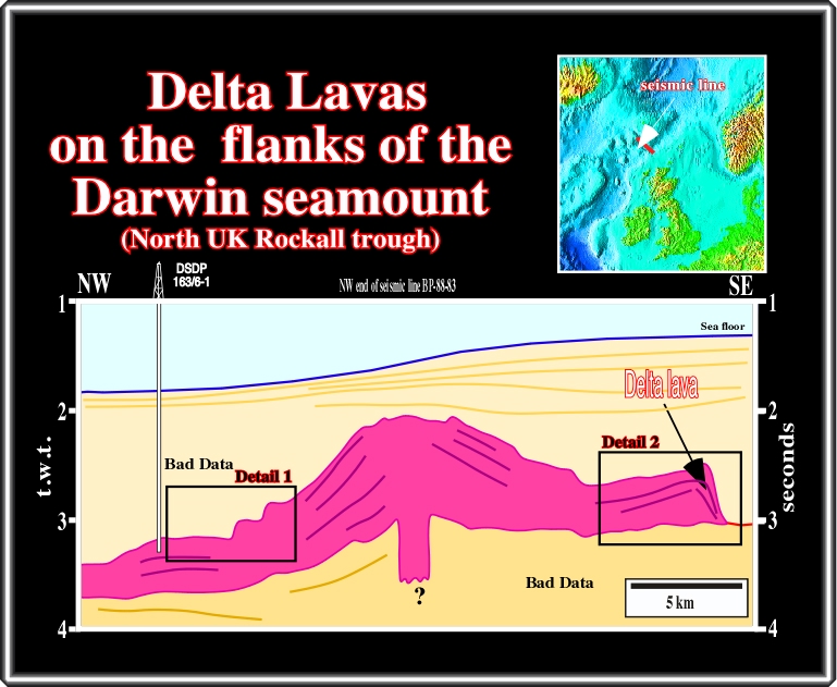
For those still doubting, the seismic line through Darwin seamount (offshore North UK), illustrated above, and the results of the DSDP 163/6-1, give them a convincing geological model explaining how SDRs and particularly delta-lavas were formed, at least in North Sea.
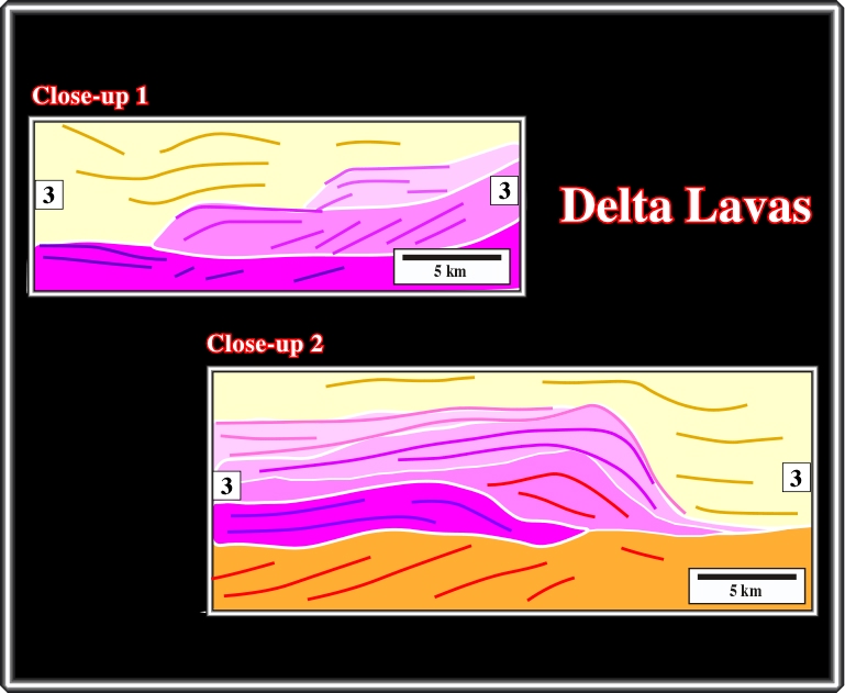
These close-ups show of the geometry created by volcanic material when it becomes frozen under water. Such a geometry is similar to that of a clastic delta, but the slope angle is much higher in a delta-lava. The geometry, and particularly the backstepping in close-up 1, suggests successive relative sea or lake level rises as subaerial spreading goes on.
In eastern Greenland, the SDRs are known since long time. In 1988, Larsen and Jakoksdottir published this seismic line, in which subaerial lava-flows are quite evident as well as the limit between their realm and the oceanic crust, that is to say the COB (continent oceanic boundary). The organic rich sedimentary intervals posterior to the SU unconformity are too thin to develop a generating petroleum sub-system, i.e., mature source rocks.
We are going to jump over the Eastern Canada (Flemish Cap, North and South Terra Nova basin) because as we will see later, this area, which matches with the offshore Iberia, seems to have a particular opening history in terms of water-depth of the spreading centres. Though, southward of this area, as well as northward, seaward dipping reflectors are recognized in all regional seismic lines, as in the one illustrate below.
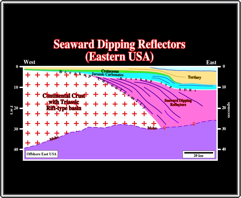
On the eastern part of this line (data from Talwani, 2000), below the Jurassic carbonate bank, lava-flows thinning landward are easily recognized just above the breakup unconformity. However, their seaward terminations are highly speculative: The geometric relationships with the Moho discontinuity are not quite clear.
Notice, that term oceanic crust is referred to two major lithological geological intervals overlying the upper mantle, which is mainly composed by peridotites (see figure below):
(i) Basaltic crust, at the top and
(ii) gabbros at the base.
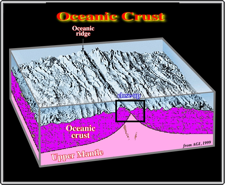
The major difference between SDRs, that is to say, the major difference between the subaerial crustal and the oceanic crust is just the absence of lava-flows in the oceanic crust. Indeed, under water, the lava-flows are replaced by pillow lava since the volcanic material cannot flow under water. Besides that, in both types of volcanic crust, the sheeted dikes are present (see plate below).
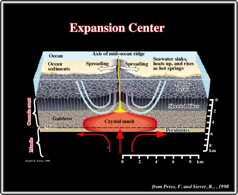
Notwithstanding the fact that this plate is highly schematic, it put forward how the ocean crust is formed at mid-ocean ridges. A hot mush of crystals and melt (red) rises from the mantle at the axis of the mid-ocean ridges. The melt is concentrated in a small shallow lens (yellow) from which dikes of magma erupt repeatedly to form sea floor pillow lava and underlying sheeted dikes. The mush cools to form the gabbro layer of the crust as the plates spread apart.
A mechanism explaining the creation of oceanic crust was proposed, in 1973, by Y. Bottinga: Fusion-Percolation-Segregation. Indeed, he suggested that when mantle material (solid state) is pushed upward, it is transformed in a kind of “sponge” soaked of basaltic liquid (magma), which amount increases with the upward movement. If this “sponge” is pressured, it ejects the liquid into surface forming the sheathed dikes and the pillow lava, while the residual solid material stays on the bottom forming the peridotites that we find below the gabbros. Geologically speaking, the rising of mantle material, their partial fusion (between 1-10%) and the expulsion of magma is continuous process. Each new portion of lithosphere migrates laterally, by the spreading, and it is immediately replaced, at the axis, by a new portion lithosphere and so on.
to continue press
next
![]()
Send E-mail to carloscramez@gmail.com or to carlos.cramez@bluewin.ch with questions or comments about this conference.
Copyright © 2006 CCramez
Last modification: August, 2014