
A3- Brazil Offshore (Pelotas offshore):
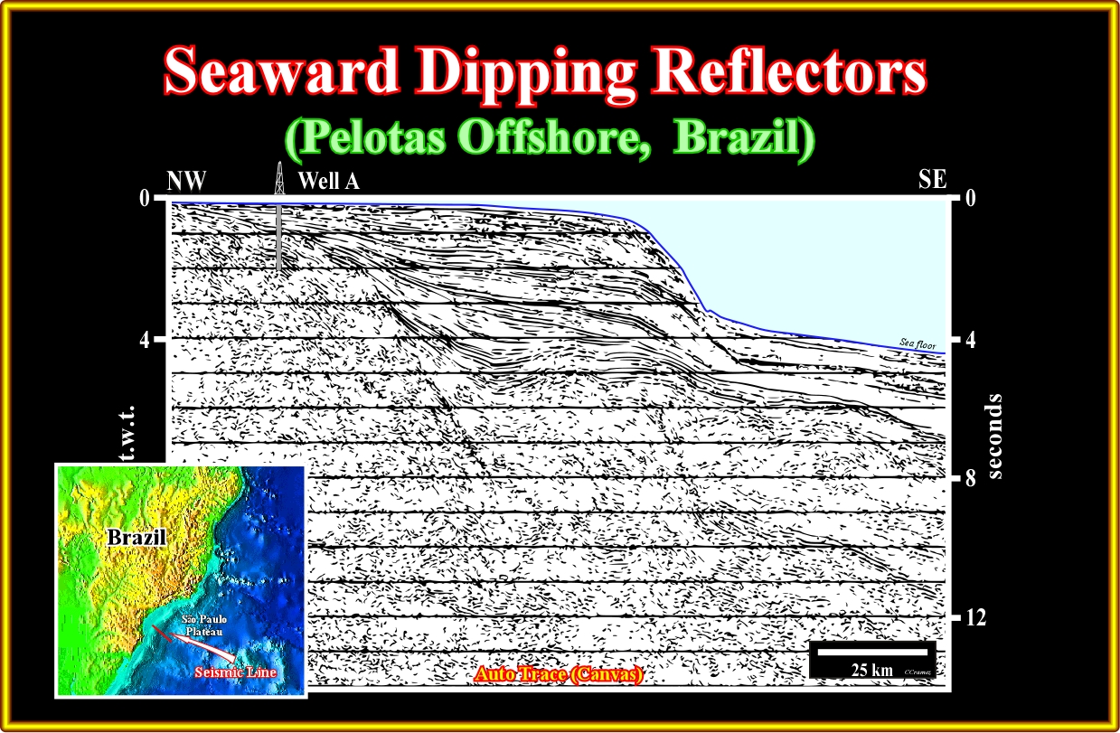
Plate A3.01- On this seismic line from Pelotas geographic basin, seaward dipping reflectors are well visible in the lower western part of the line. In the eastern lower part of the line, the dip of the reflectors is, strongly, exaggerated due to the pitfall induced by the abrupt increasing of the water depth. As illustrated, exploratory wells, drilled in the conventional offshore, corroborate the volcanic facies (lithology) of these seaward dipping reflectors, which seem correspond to sub-aerial lava-flows.
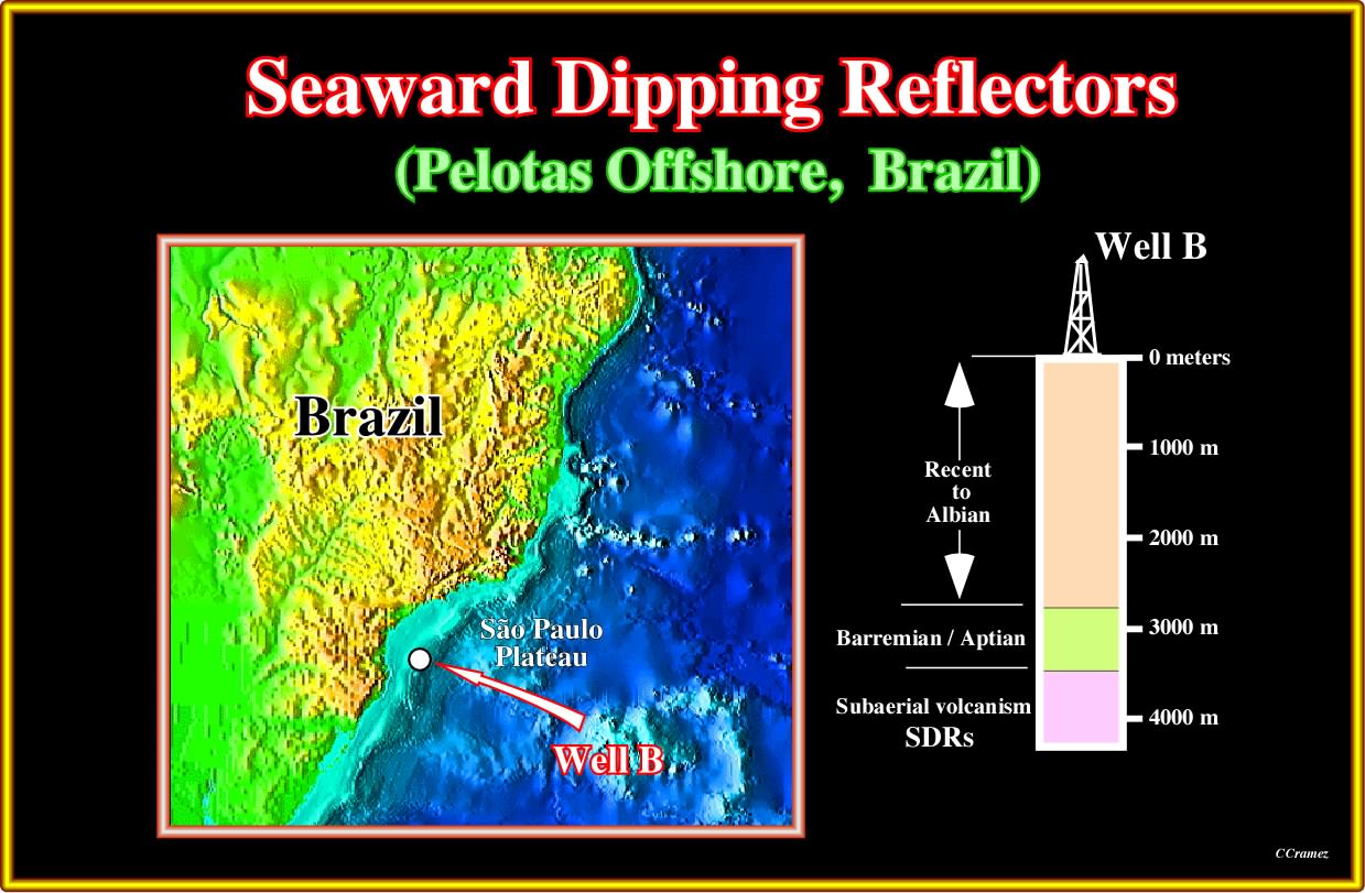
Plate A3.02- The well's results illustrated on this plate correspond, more or less, to the exploratory well projected on the previous seismic line. Below the transgressive Barremian-Aptian interval, the well penetrated more than 500 meters of sub-aerial volcanic material, which were deposited after the breakup the Gondwana lithosphere.
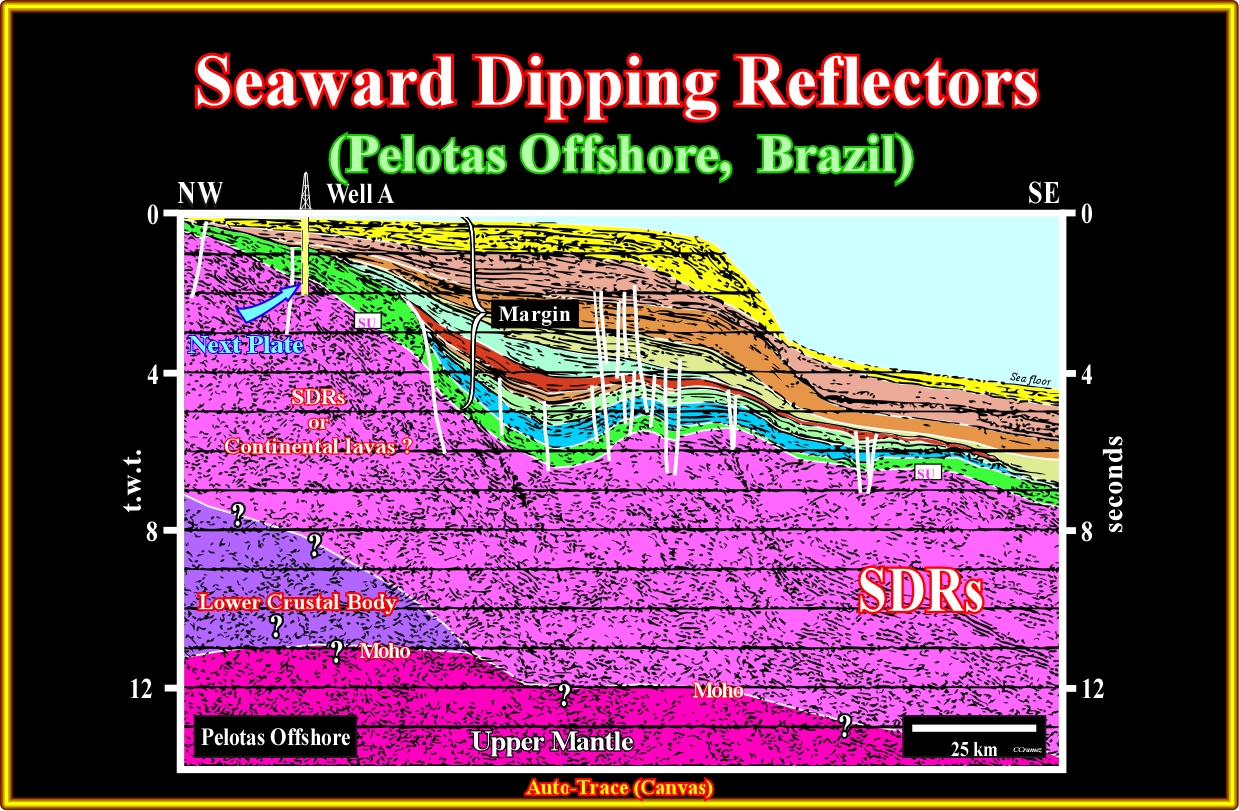
Plate A3.03- On this tentative geological interpretation interpretation of the seismic line illustrated on plate A3.01, a lower crustal body and the Moho discontinuity (limit between the upper mantle and the crust), are speculative. The margin sediments overlie the sub-aerial lava-flows (SDRs). No rift-type basins are recognized on this line. However, as illustrated on the next plates, certain geoscientists, erroneously, believed to perceive rift-type basins, even on this seismic line, what was, completely, falsified and explained, long time ago, by Celso Ponte, as we will see next.
Plate A3.04- On this close-up of the uppermost western part of the previous seismic line (or of a nearby parallel line), several wedge of seaward dipping reflectors, are individualized by post-depositional normal faults looking westward. In the 80's, before drilling, the large majority of Petrobras' geoscientists interpreted these normal faults as the faults bordering the half-grabens of the rift-type basins and considered the infilling reflectors as induced by potential source-rocks equivalent to the Cabinda Bucomazi formation, in Angola offshore (oral communication of our regretted friend Celso Ponte). After drilling, this seismic line, as well all lines shot in the area were tentatively interpreted as illustrated in the next plate.
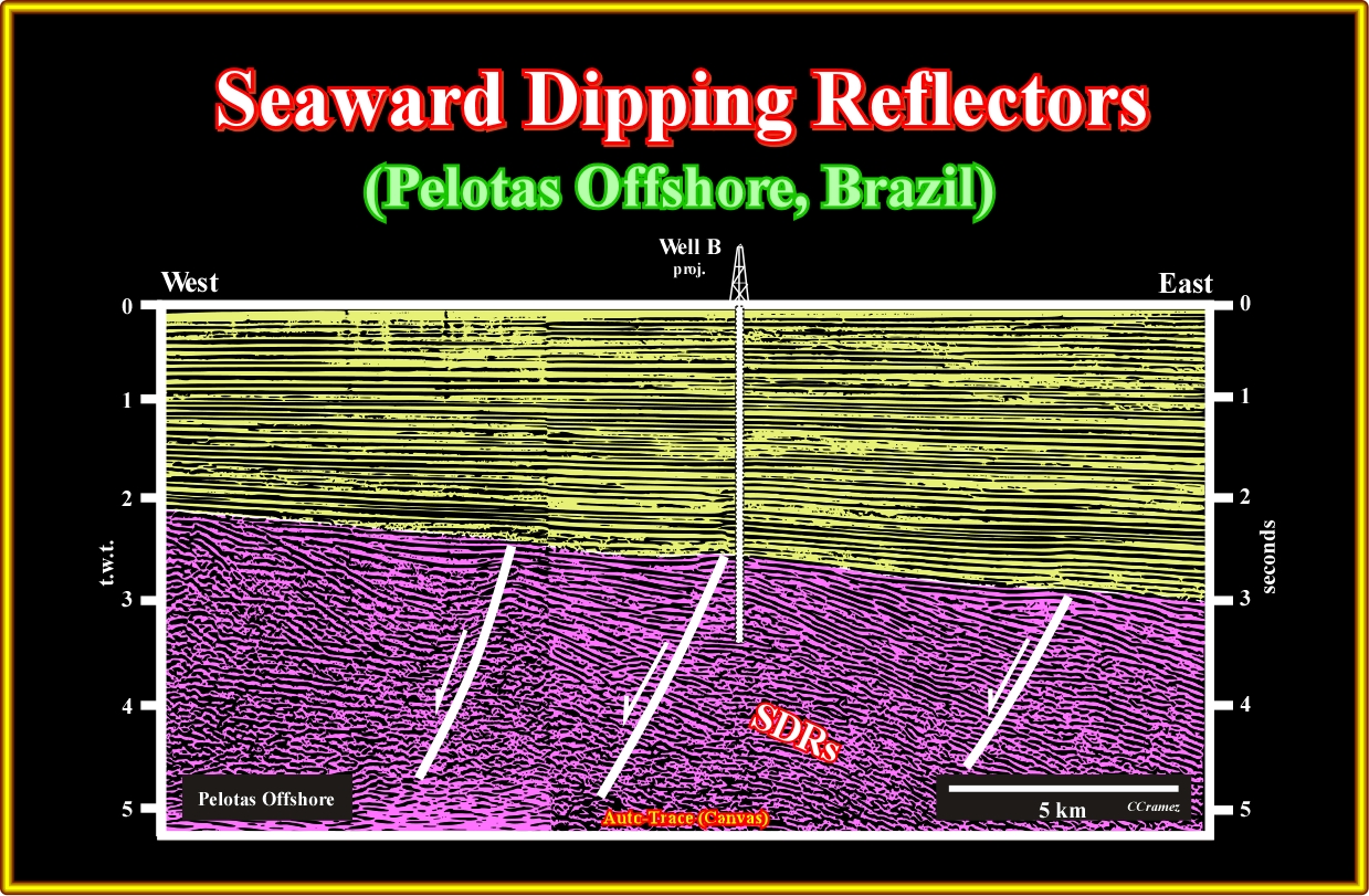
Plate A3.05- The previous close-up can be tentatively interpreted as illustrated on this plate, i.e., the seaward dipping reflectors, which initially had a sub-horizontal geometry (lava-flows) become, progressively, tilted seaward due to the loading of the younger lava flows. Such a seaward tilting (lengthening) is favored by the development of normal faults (normal faulting is the unique geological process allowing lengthening) looking toward the continent. Such a tilting, which is accompanied by normal faulting, seems to develop, in the proximal part of the basin a slightly uplift (relative sea level fault), which induces a local erosion, responsible of the present geometry of the lava-flows as depicted on the next plate.

Plate A3.06- Petrobras' geoscientists, after drilling, that is to say, since the exploratory wells indicate that the predicted source-rock interval was, in fact, a stacking of sub-aerial lava-flows, considered the half-graben geometry of the seaward dipping reflectors as the result of an amalgamation of deposition, subsidence (tilting-lengthening) and erosion. The level of erosion determines the exposure or not of the normal faulting. As illustrated on this plate, a shallow erosion's level (erosion 1) allows the appearance of normal faults and half-grabens (fake rift-type basins), while a deep erosion's level remove them, completely, from recognition. So far, such conjecture was not falsified by new data (seismic lines and well's results).
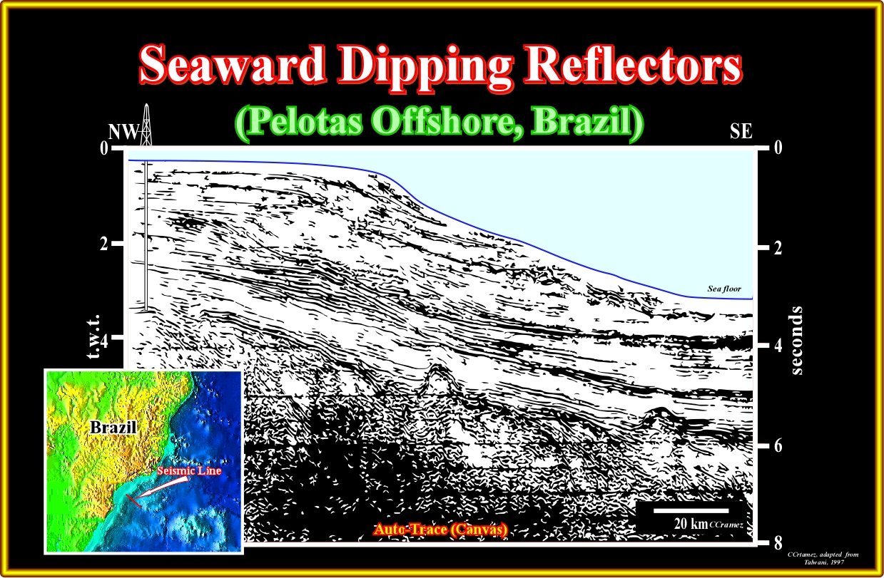
Plate A3.07- On the western part of this seismic line (eastward of the drilled exploration well), the graben (normal faults with opposite vergence ) on the top of the seaward dipping reflectors (eastward of the exploratory well ) underlies the dip change of the seaward dipping reflectors, which, locally, are cut by volcanoes. The dip of the SU unconformity (unconformity on the top the sub-aerial lava-flows) is exaggerated in the eastern part of the line due to the pitfall induced by the water depth variation.
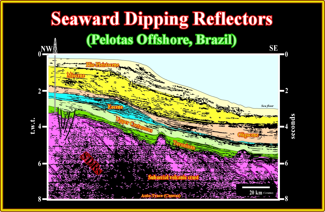
Plate A3.08- The previous seismic line can, tentatively, be interpreted, in geological terms, as illustrated. The seaward dipping reflectors and the volcanoes are obvious, as well as, the graben structure (lengthening) on the top of the SDRs. As theoretical predicted there are not rift-type basin above the SDRs, since the rift-type basins predate the breakup of the lithosphere, what is not the case of the SDRs, which postdate it. On the contrary, in the margin the Mesozoic transgressive phase, characterized by its retrogradational geometry is, easily, differentiate of the overlying regressive phase (progradational geometry).
A4- Brazil Offshore (Santos Offshore):
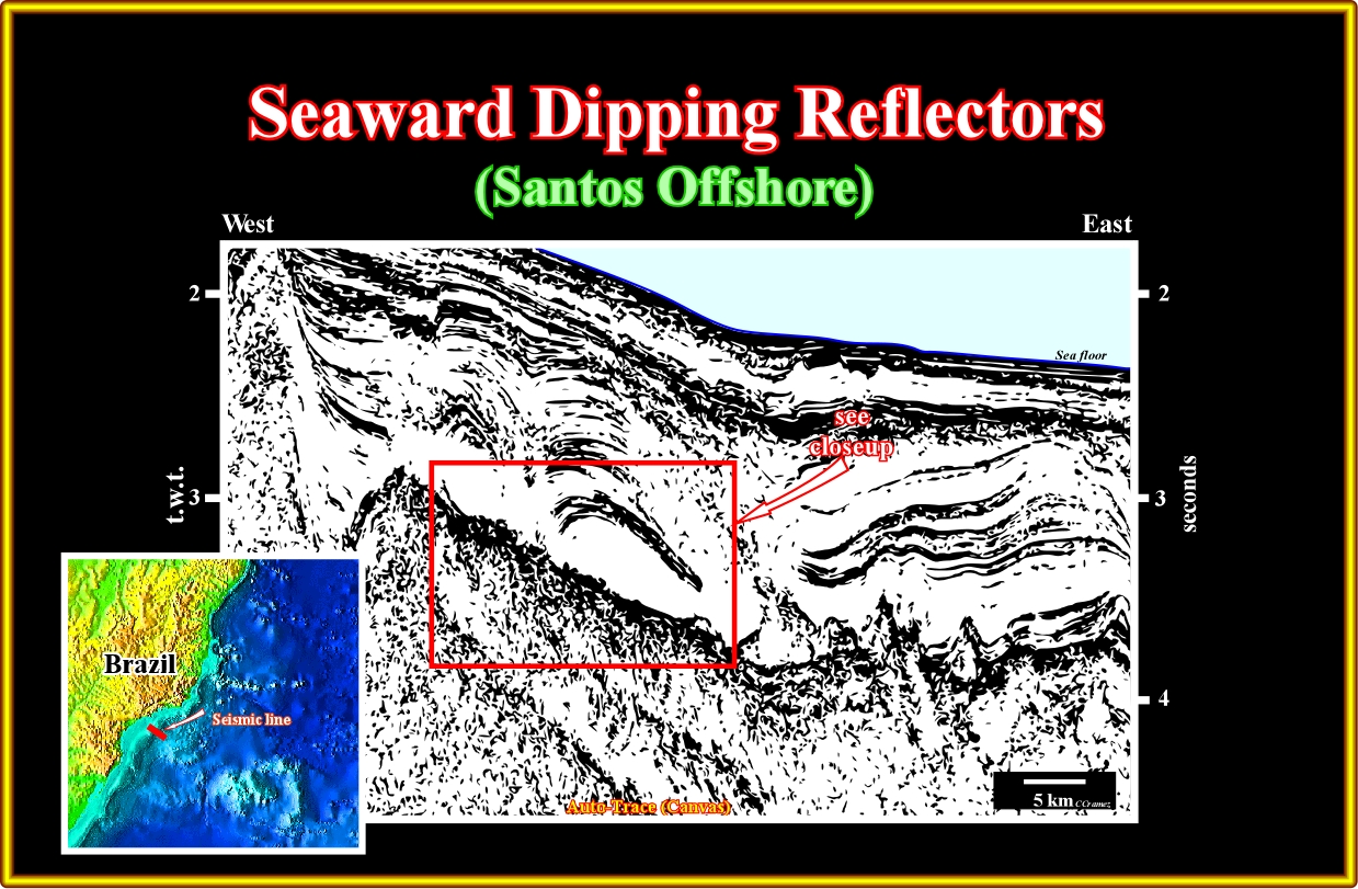
Plate A4.01- Northward of the Pelotas geographic basin, in the Santos geographic basin, where huge oil accumulation have been found in infra-salt margin sediments (sag basin of the Petrobras' geoscientists), seaward dipping reflectors are quite evident when the infra-salt margin interval is, relatively, thin (particularly under seismic resolution), as it is the case central part of this line (see close-up below), in which the supra-salt margin sediments are, clearly, recognized by the deformation induced by the salt movements. The seaward dipping of the sub-aerial lava-flows are not too evident on this line, but on the following close-up their geometry is quite evident.
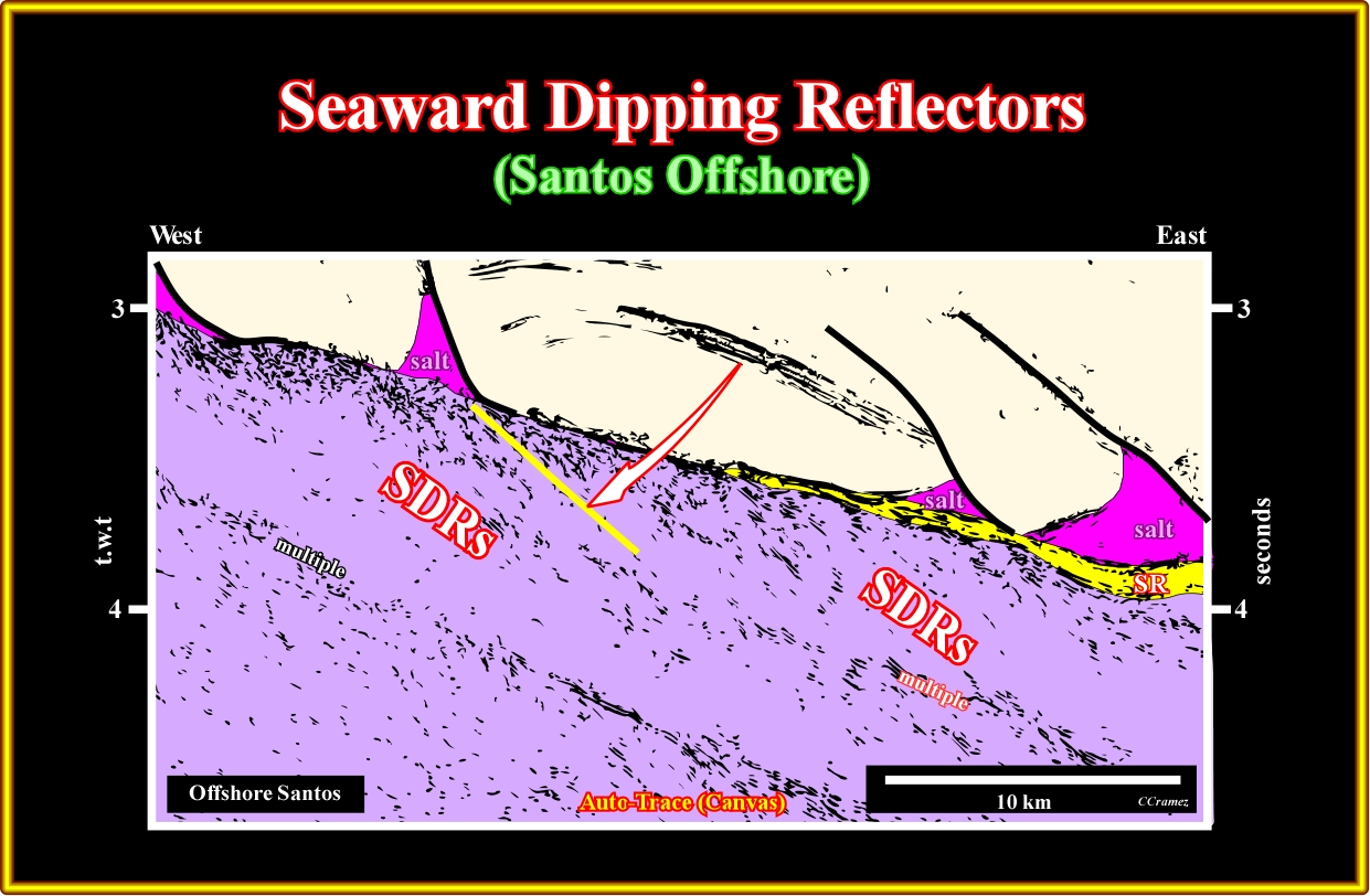
Plate A4.02- Below the infra-salt margin sediments (under seismic resolution in the western part of the seismic line), that is to say, below the SU unconformity (top of the sub-aerial lava-flows), the seaward dipping reflectors (SDRs) are quite obvious, if you take into account the multiple reflected seismic energy (event in seismic data that has incurred more than one reflection in its travel path). On this seismic line, the breakup unconformity is not visible (don't forget that theoretical and a priori, it is located at the base of the SDRs, since they postdate the breakup of the lithosphere), the seaward dipping reflectors are evident below the supra- and infra-salt margin sediments.
A5- Brazil Offshore (Cabo Frio Offshore):
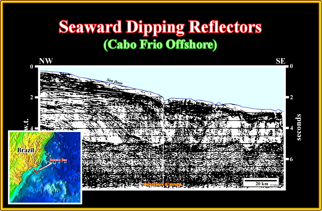
Plate A5.01- On this seismic line, below the tectonic disharmony associated with the base of the evaporitic interval, infra-salt margin sediments are recognized in the central and eastern part of the line. These sediments lie on seaward dipping reflectors (SDRs) , which top mark the SU unconformity. Pay attention to the fact that, there are not rift-type basins overlying the SDRs. This corroborate, i.e., don't falsify the conjecture that the SDRs postdate the breakup unconformity, which is located at the bottom of the sub-aerial volcanic crust.
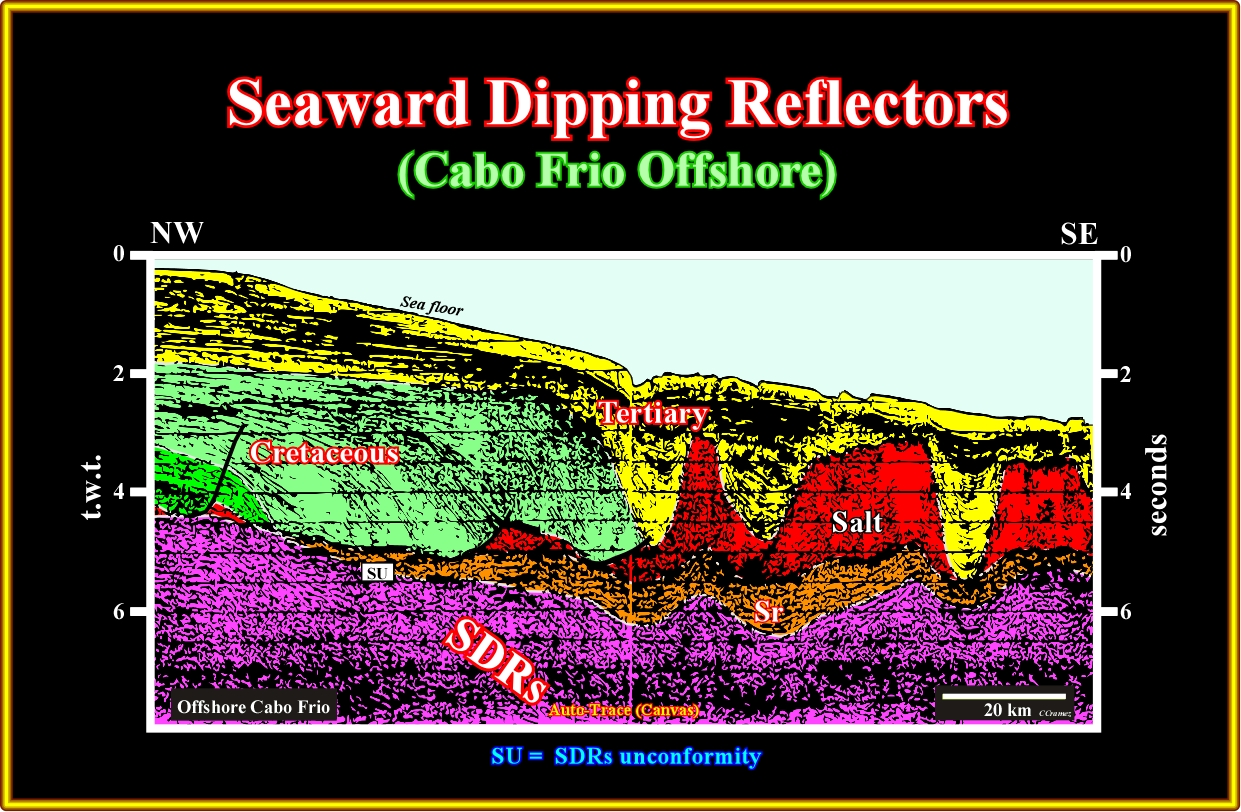
Plate A5.02- On this tentative interpretation of the previous line the tectonic disharmony is evident. It is, locally, represented by salt welds (absence of salt or a salt thickness lower that seismic resolution). The infra-salt margin sediments, which here are rich in organic matter (potential source-rock interval) are identified, readily, between the evaporitic interval (or a salt weld) and the SDRs. On the eastern part of the line, the Tertiary depocenters and salt's thickness variations, in addition of the eastward dip of the sea floor, induce in the underlying intervals an apparent wavy geometry, which mask the seaward dipping of the volcanic material.
A6- Brazil Offshore (Campos Offshore):
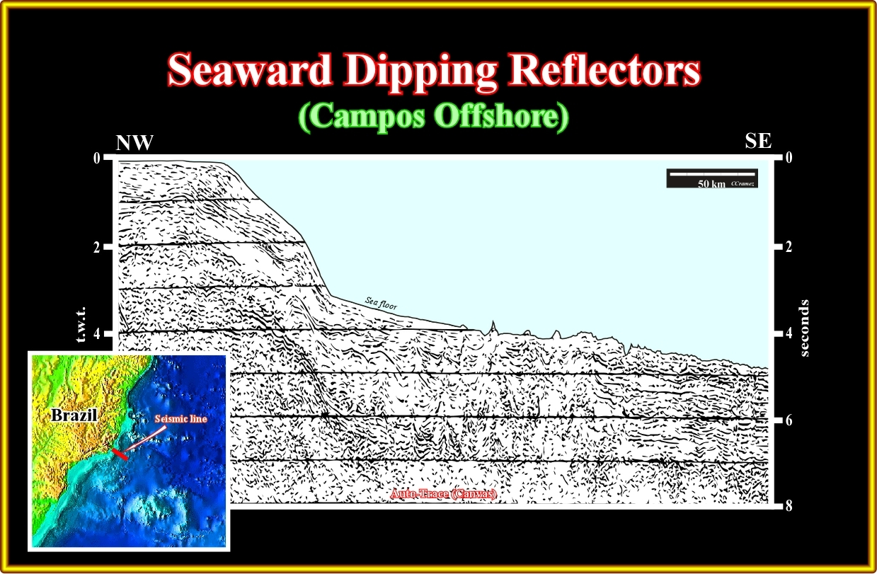
Plate A6.01- On this regional line of the Campos geographic basin, it is quite easy to see the formation of the rift-type basin is restrained to the continental crust. In reality, the continental crust was lengthened by normal faulting with formation of rift-type basins. However, since the breakup of the lithosphere took place, the continental crust was anymore lengthened, but drifted. Certain geoscientists go further. They think when the continental crust' thickness (during the lengthening) reach 10-15 kilometers, which corresponds, more or less, to β ± 4 (coefficient of extension) the continental crust cannot anymore be lengthened by normal faulting : it is highly injected by mantle material and breakup. Eastward, below the margin sedimentary prism, the trilogy Continental Crust (rift-type basins included), Seaward Dipping Reflectors and Oceanic Crust, is perceivable, as illustrated next.

Plate A6.02- On this tentative interpretation, the breakup unconformity (BU) is, easily, recognized in the western part of the line, where it separates the rift-type basins from the infra-salt margin sediments, except in the central part, where it is fossilized by the onlapping of the SDRs. The SU unconformity (top of the SDRs) and top of the oceanic crust are also, readily, recognized by the bottom of the salt and, seaward, by the hummocky morphological interface between the sediments and oceanic crust. Seismically speaking, generally, there are not SDRs overlying the rift-type basin. On other words. if there are SDRs overlying the rift-type basins, their thickness is under seismic resolution. Once again, notice the pitfalls induced by the abrupt changes in water depth.
A7- Brazil Offshore (Espirito Santo Offshore):
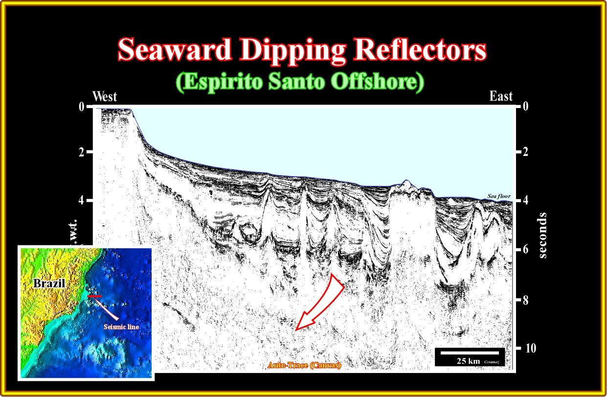
Plate A7.01- On this regional seismic line of the Espirito Santo geographic basin, the substratum of the margin sediments is composed by seaward dipping reflectors. It logically to assume that, in this part of the offshore, there are not rift-type basins, since they predate the emplacement of the sub-aerial lava-flows, which begins with the breakup of the Gondwana lithosphere.
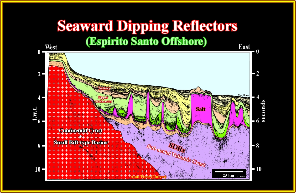
Plate A7.02- Below the evaporitic interval, particularly in the western part of the line, infra-salt margin sediments are recognized, readily. A thick post-breakup sub-aerial volcanic interval (seaward dipping reflectors) forms the infra-structure of the margin. The wavy geometry of the SU unconformity (top of the SDRs) is induced to the lateral velocity changes induced by the evaporitic interval and Tertiary depocenters. The seaward dipping of the sub-aerial lava-flows is not to evident since the reflectors below the salt interval area too masked.
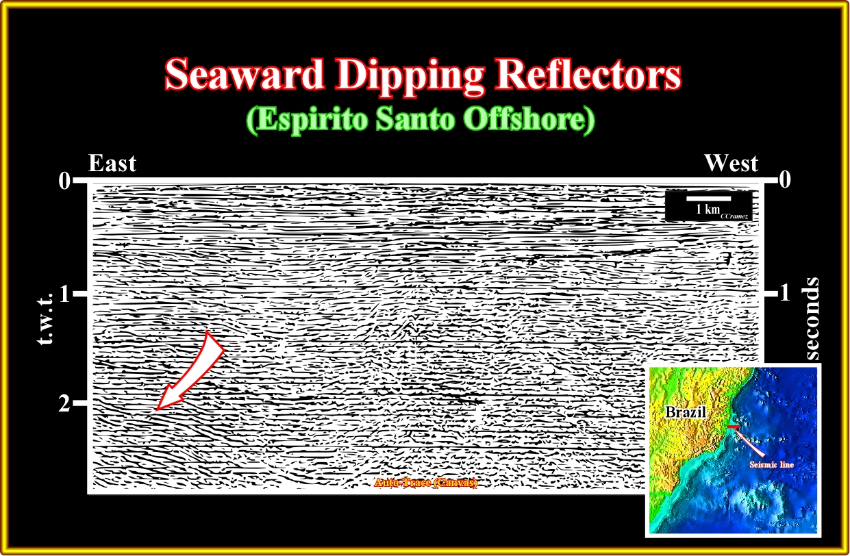
Plate A7.03- This seismic line, shot not far from the previous one (a little bit landwards) illustrates the occurrence of volcanics in the supra-salt margin interval. Seismically speaking, such sub-aerial volcanic deposits are recognized, mainly, by their progradational geometry and particularly by the downlap termination of the associated reflectors (see tentative interpretation on next plate).

Plate A7.04- On this preliminary tentative geological interpretation of the previous line, below the evaporitic interval the dipping seaward reflectors can be interpreted as sub-aerial lava-flows postdating the breakup unconformity. Such a sub-aerial volcanism (SDRs) cannot be confounded with the volcanism postdating the salt interval, since its age and morphology are completely different.
A8- Brazil Offshore (Jacuipé Offshore):
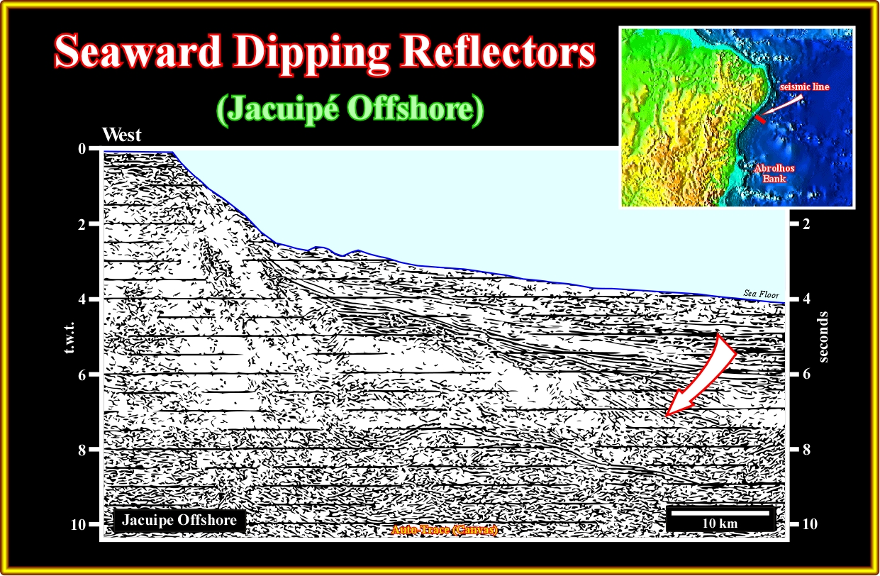
Plate A8.01- This regional seismic line from the Jacuipé offshore has been used by all Brazilian geoscientists to illustrated the geometry and emplacement of the sub-aerial lava-flows associated with the breakup of the Gondwana. As illustrated on the tentative geological interpretation (plate A8.02), the SDRs postdate the rift-type basins and their geometry (reflectors dipping seaward) contrasts with the internal configuration of the rift-type basin, which, generally, dip landward, as illustrated by a rift-type basin, in the upper western part of the tentative interpretation (see below).
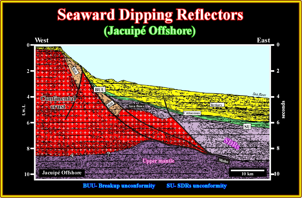
Plate A8.02- As suggested on this tentative geological interpretation, not only the SDRs overlie the distal rift-type basin, but their dip is opposite to the dip of the sediments in filling the rift-type basins, as well. Excepting few rare rift-type basins, as the westward one illustrated on this seismic line, the large majority of the rift-type basins developed during the length of the Pangea's continental crust, has a half-graben geometry with the bordering normal looking seaward, i.e., the internal reflectors have a continentward dipping. The sub-aerial lava-flows dip seaward, while the internal reflectors of the rift-type basin dip landward, as illustrated on this tentative interpretation.
A9- Brazil Offshore (Sergipe Alagoas Offshore):
Plate A9.01- In spite of the fact that any exploration well had corroborate the facies (lithology) of the seaward dipping reflectors, in this offshore (Sergipe-Alagoas), they have been interpreted, since longtime, on the seismic lines and corroborated by potential methods (magnetics and gravimetry).
Plate A9.02- On this tentative geological interpretation, SDRs (traversed by volcanic plugs) are obvious in the eastern part of the line, overlying the upper mantle and eastward of the continental crust. Rift-type basin are, easily, recognized in the continental crust (western part of tentative interpretation). Contrariwise to the dip of the SDRs, the sediments infilling the rift-type basins dip landward. All exploratory wells were located on the platform and uppermost part of continental slope, that is to say, that they could not reach the SDRs.
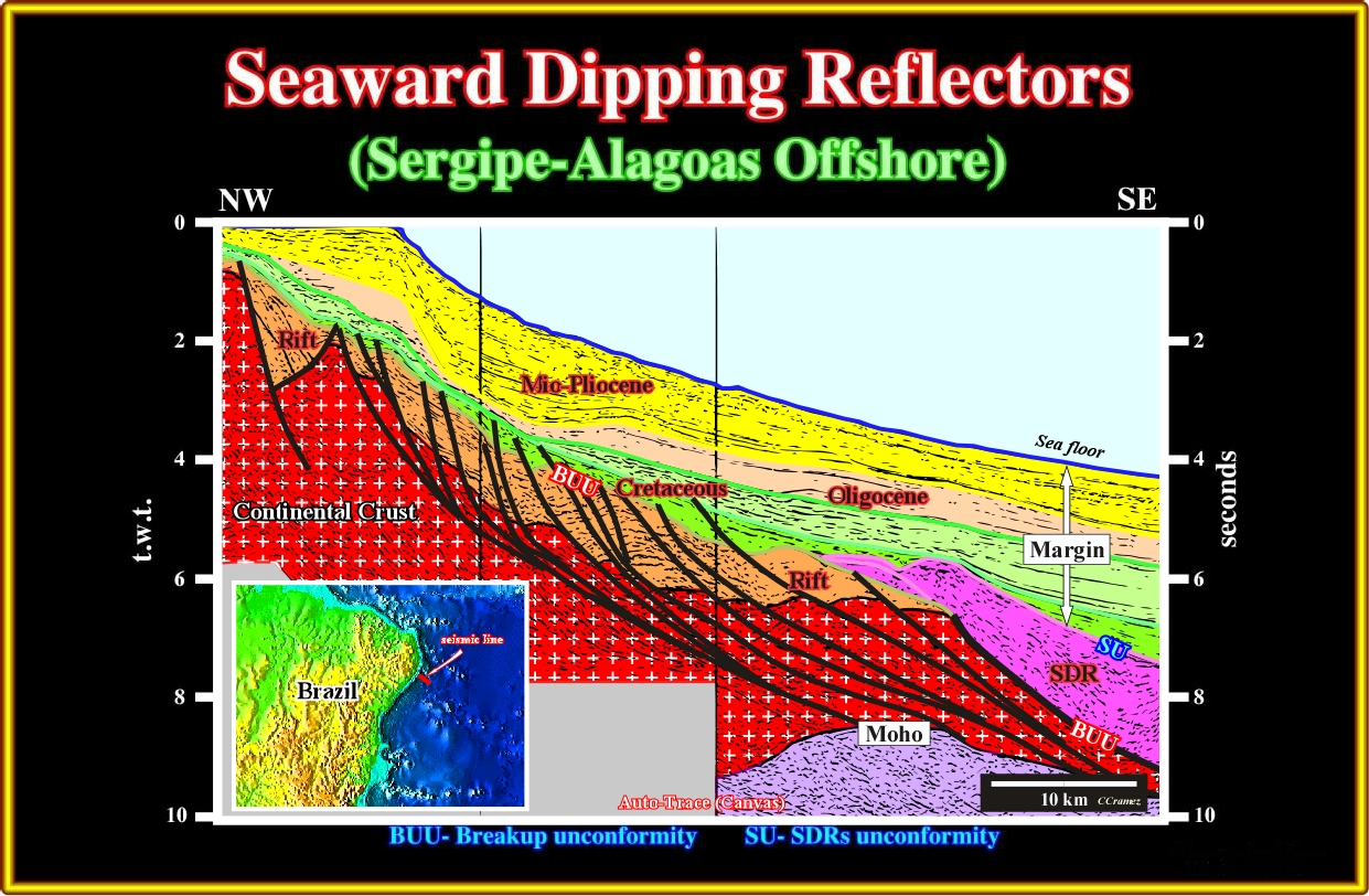
Plate A9.03- This line, parallel to the previous one, has been published several times by the Brazilian geoscientists not only to illustrate the SDRs but the lengthening of the continental crust as well. As depicted, the initial lava-flows seem to cover the more distal rift-type basins. The normal fault bordering the more westward rift-type basin having an anomalous landward vergence, the infilling sediments dip seaward as the SDRs.
A10- Brazil Offshore (Pernambuco / Paranaíba Offshore):
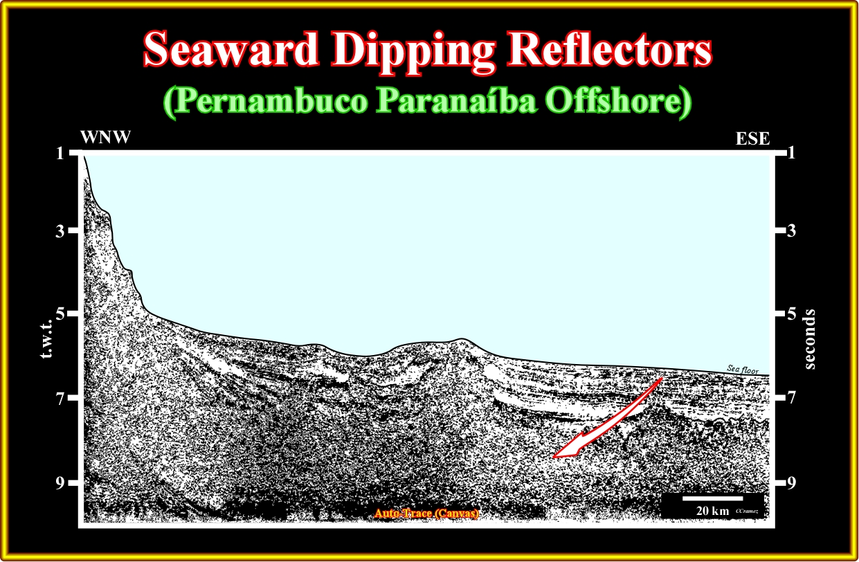
Plate A10.01- In spite of its bad quality, this seismic line of the Pernambuco-Parnaíba offshore can be used to illustrate the sub-aerial lava-flows (SDRs) and their transition to the oceanic crust, which is crossed by several volcanic plugs, as depicted in the tentative interpretation below.
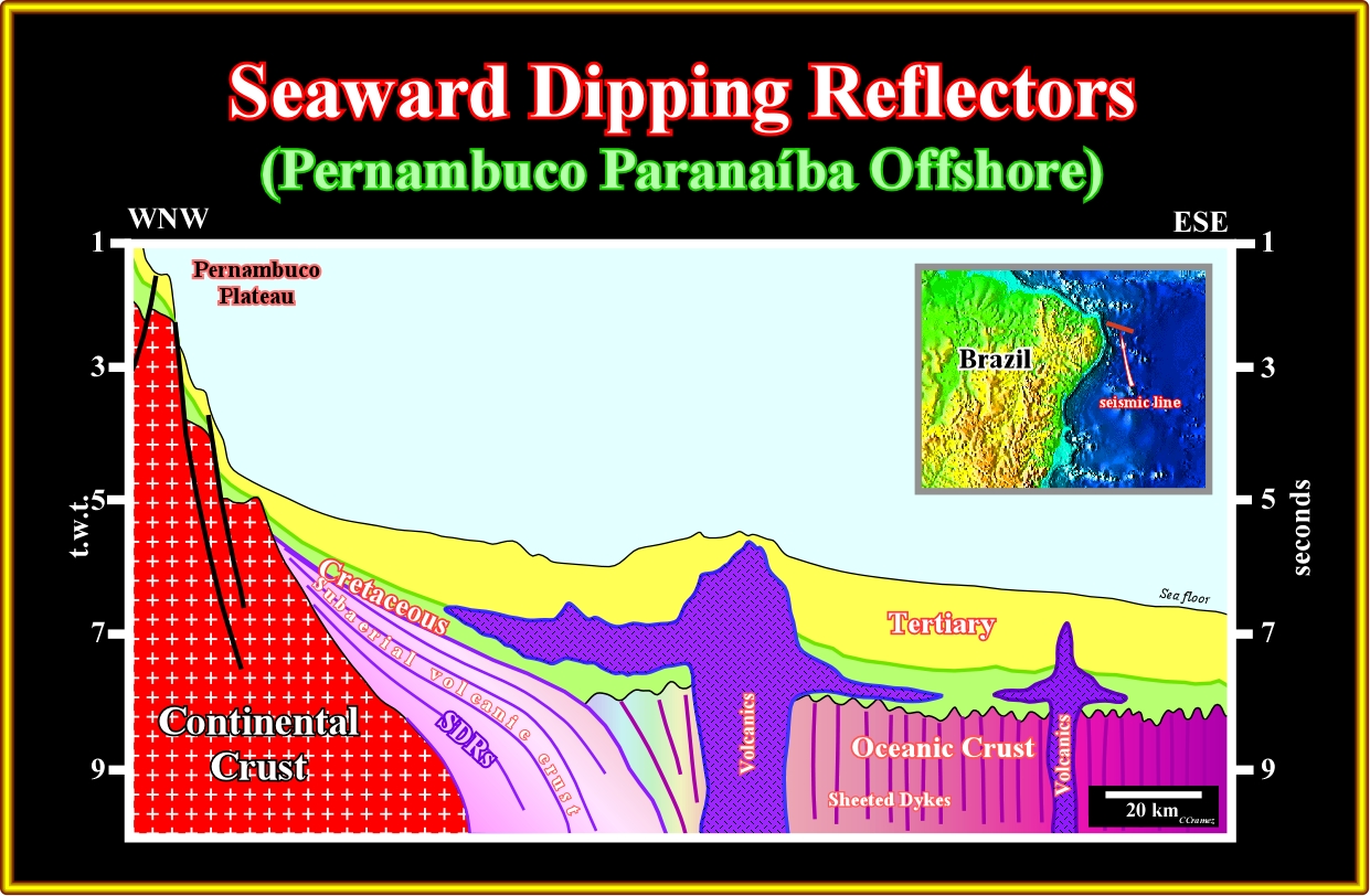
Plate A10.02- This tentative interpretation of the previous line illustrates the evidence of the SDRs and the transition to the oceanic crust. It is easily to hypothesize that the development of the SDRs is just associated to a sub-aerial emplacement of the sheet dykes, in other words, since the sheet dykes are under water as the volcanic material cannot flows, it froze forming the oceanic crust (pillow lava). Brazilian geoscientists suggested that the SDRs could be interpreted as rift-type basin sediments(?).
A11- Brazil Offshore (Potiguar Offshore):
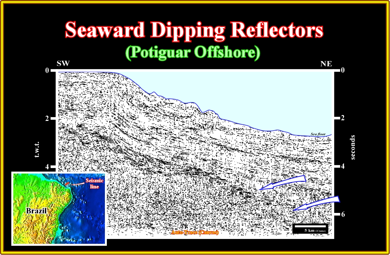
Plate A11.01- This seismic line illustrates the rift-type basin of the Potiguar offshore and oceanic crust. In spite of the fact that in this offshore the margin is more or less parallel to major fracture zones associated with the seafloor spreading (transform margin of certain geoscientists) it is possible to recognize SDRs, partially covering the rift-type basins.
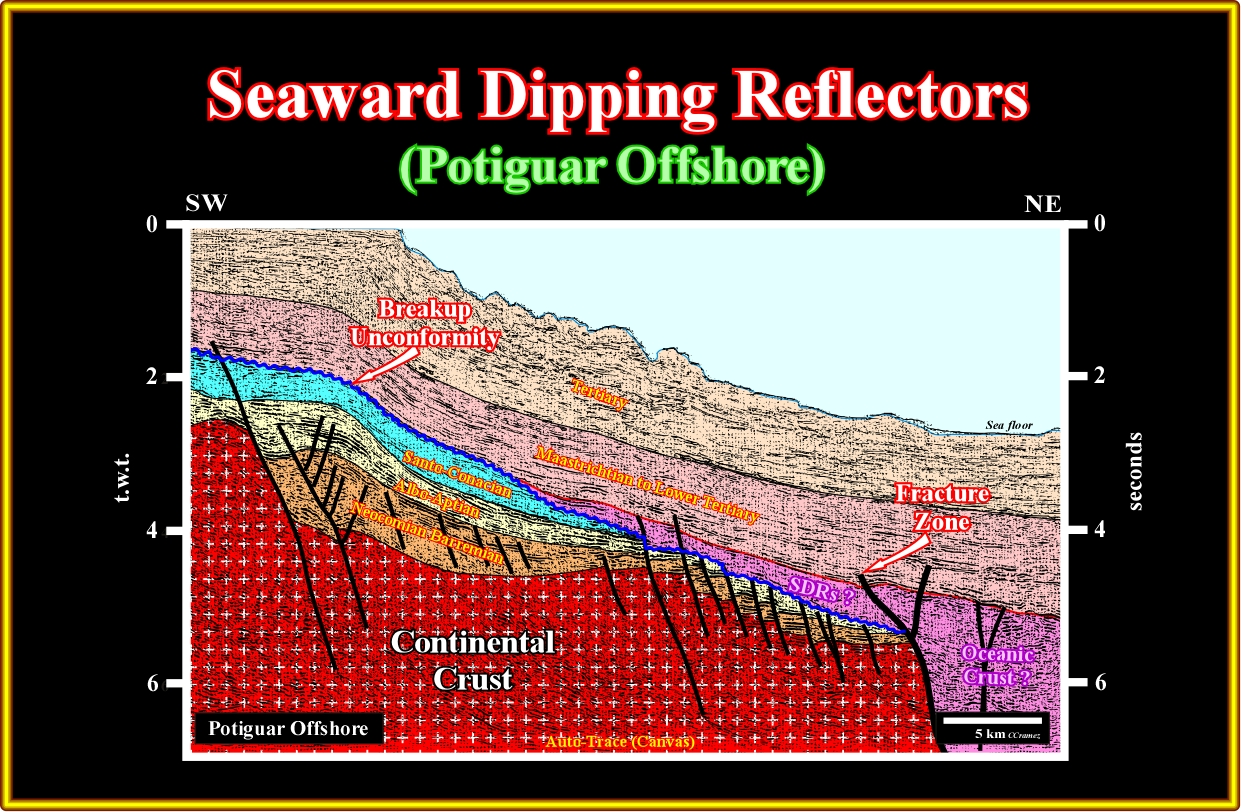
Plate A11.01- This tentative interpretation of the previous line is highly falsifiable. However, the sharp limit (major fracture zone) between the continental crust and the oceanic crust is obvious, as well as, the location of the breakup unconformity, which seems to be fossilized by SDRs, which extension is quite limited due to the fracture zone.
A12- Brazil Offshore (Mundaú Offshore):
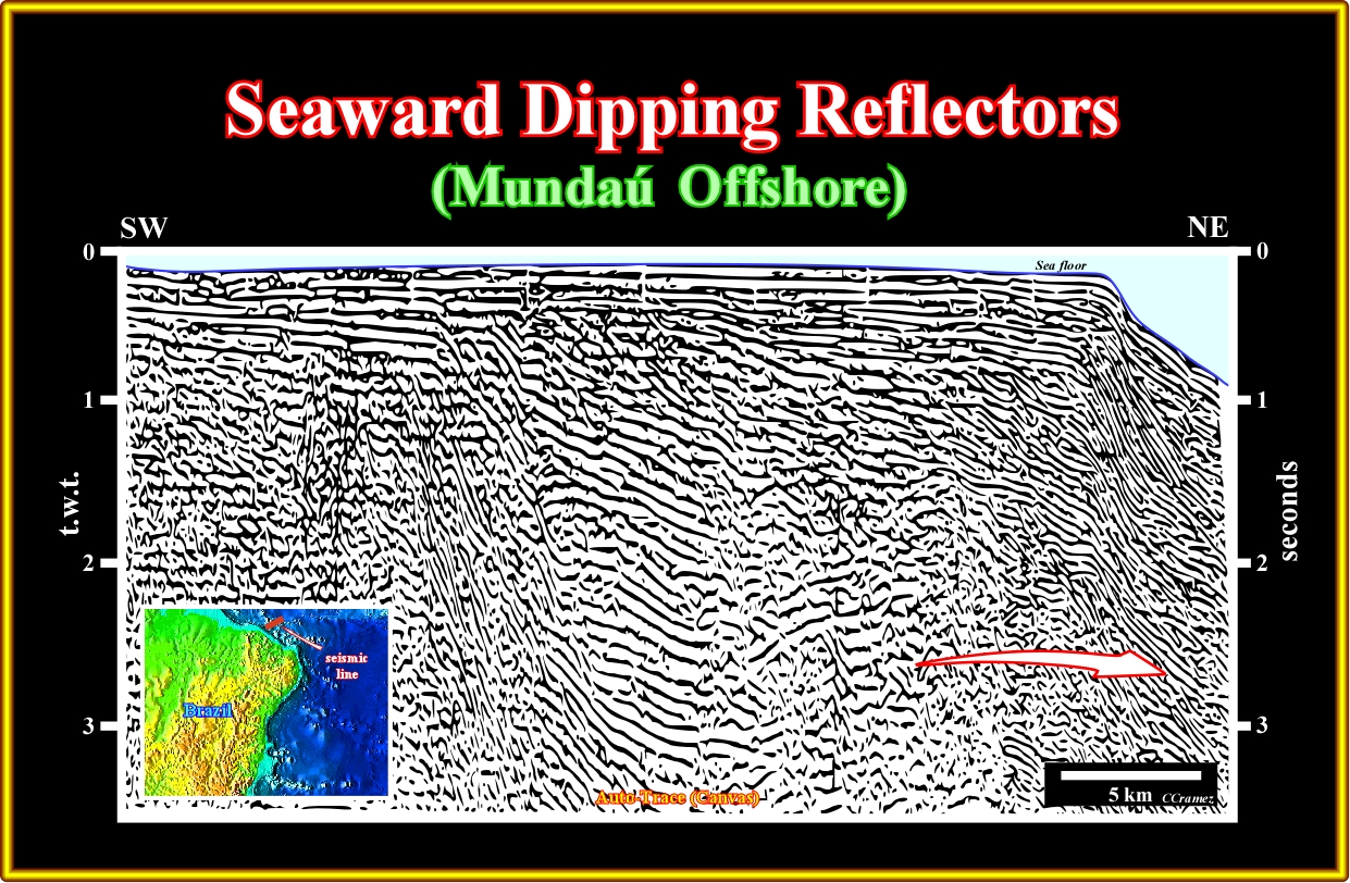
Plate A12.01- On central part of this seismic line a rift-type basin is obvious. Seaward, sub-aerial lava-flows are likely, taking into account that this continental margin is associated with transform faults. In addition to convergence and divergence margin, transform motion may occur along plate margins. Transform margins, in many ways, are less spectacular than convergent and divergent ones, and the type of plates involved is really of no significance. Along transform margins, about all t^there faults and earthquakes.

Plate A12.02- On this tentative interpretation of the previous seismic line, the more likely location for SDRs, as depicted is eastward of the continental crust above the breakup unconformity (in blue). However, the sharp change in the water depth, must be taken into account since multiple reflections are plausible.
A13- Brazil Offshore (Piauí Ceará Offshore):
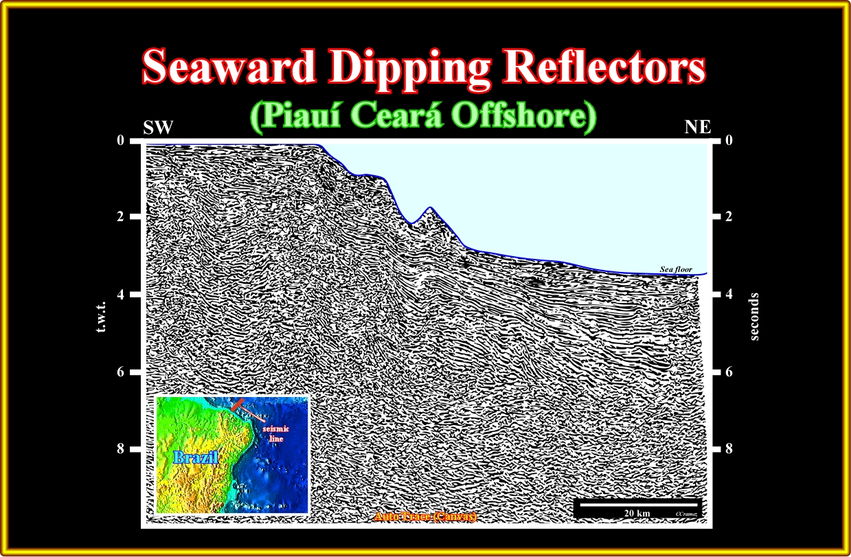
Plate A13.01- This seismic line illustrates not only the SDRs, but the shortening of the rift-type basin and margin sediments due to the motion of the fracture zone, which characterizes the Piauí-Ceará offshore.
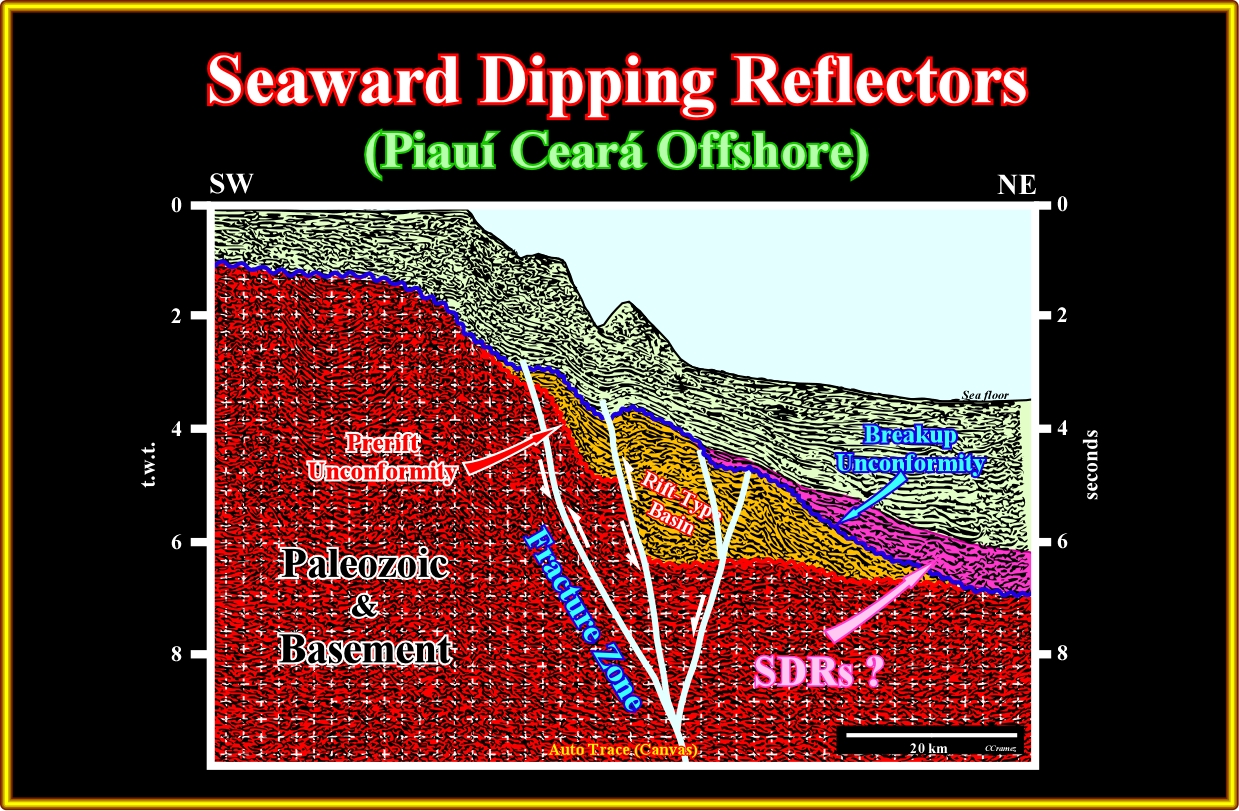
Plate A13.02 On this tentative interpretation the sub-aerial lava-flows are very likely, as well as, the pre-rift and breakup unconformity. The rift-type basin and margin sediments are shortened by the lateral movement of the fracture. If such a tentative in not falsified by other data, on can say that the SDRs cover and fossilized the distal rift-type basins. As illustrated later, on the opposite sidewalk, that is to say, in the Gulf of Guinea, the rift-type and margin sediments are, also, shortened by the motion of the fracture zones and the margins can be considered, at least partially, as transform margins.
A14- Brazil Offshore (Barreirinhas Offshore):
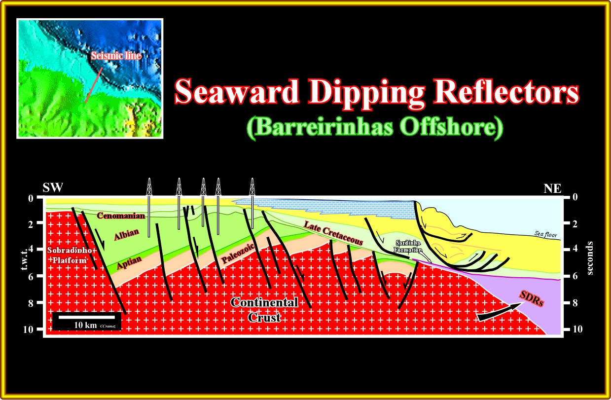
Plate A14.01- This tentative interpretation of a Petrobras seismic line assume the presence of seaward dipping reflectors below the margin sediments in the eastern part of the line. The rift-type basins, as well as, the breakup unconformity are obvious.
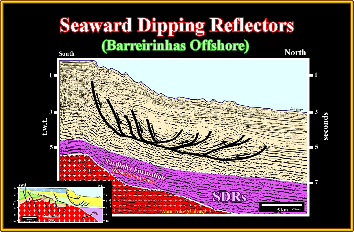
Plate A14.02- Laterally to the seismic line interpreted in the previous plate, this seismic line illustrates quite well the sub-aerial lava flows (Sardinha formation of the Brazilian geoscientists), as well as, the local extension and shortening of the margin sediments. In a listric faulting, the shortening of the sediments is a response to the up-dip extension associated to a slope failure. The term listric faulting (normal fault geometry up-dip and reverse fault geometry down-dip) comes from the Greek term listron, which means spoon (motion of a spoon) and not a curvature as it is the case in a curvilinear normal fault).
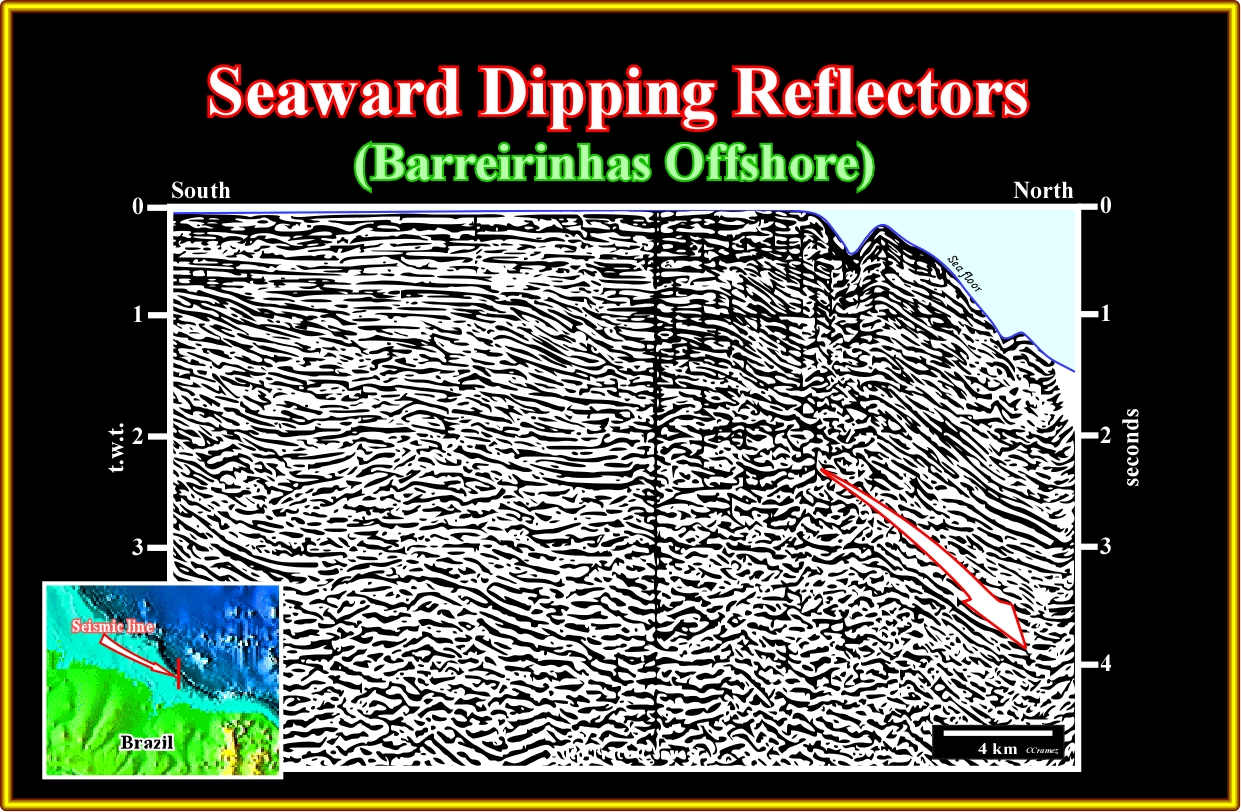
Plate A14.03- On this seismic line of Barreirinhas geographic basin, the SDRs are not to evident. However, the picking of the breakup unconformity suggest the possibility of sub-aerial lava-flows above the continental crust in the eastern part of the line.
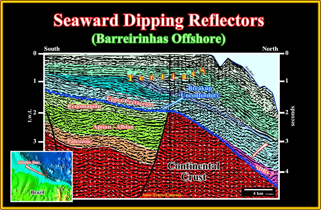
Plate A14.04- On this tentative interpretation of the previous line, the breakup unconformity is picked readily, as well as the continental crust. Overlying the breakup unconformity, the existence of seaward dipping reflectors is conceivable as depicted.
A15- Brazil Offshore (Pará Maranhão Offshore):
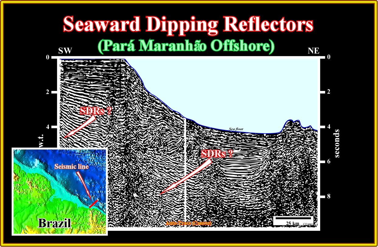
Plate A15.01- If on this seismic line of the Pará-Maranhão offshore there are seaward dipping reflectors, i.e., sub-aerial lava-flows postdating the breakup of the Gondwana lithosphere, the more likely location is the indicated.
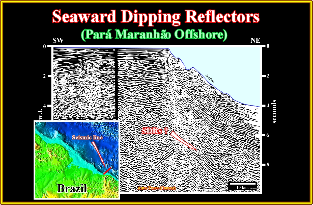
Plate A15.02- Similarly, on this line composite line of the same area of the previous line, sub-aerial lava-flows associated with the breakup of the Pangea lithosphere can be located as indicated, since. regionally. exploration wells have recognized volcanic facies (see later).
A16- Brazil Offshore (Amapá / Amazonas Offshore):
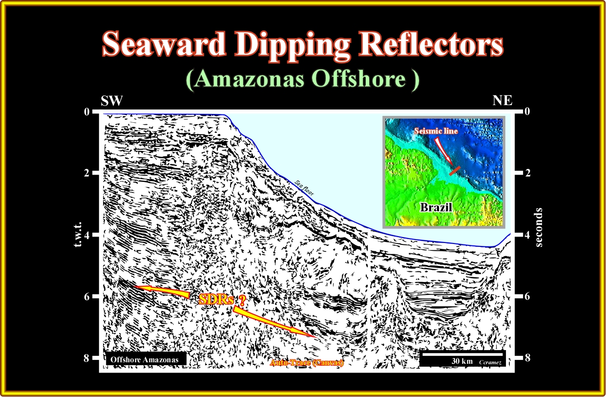
Plate A16.01- On this seismic line located westward of the previous ones, as indicated, seaward dipping reflectors are likely. In fact as illustrated next, more than 100 meters of sub-aerial lava-flows where recognized (Total-Marathon exploration well) (see next).

Plate A16.02- This exploratory well drilled, in the Amazonas offshore, drilled more than 1000 meters of sub-aerial lava-flows. The pre-drilling A post-drilling tentative geological interpretation was, completely, falsified and a new tentative was proposed taking into account the well's results. Such a new tentative is illustrated on next plate.
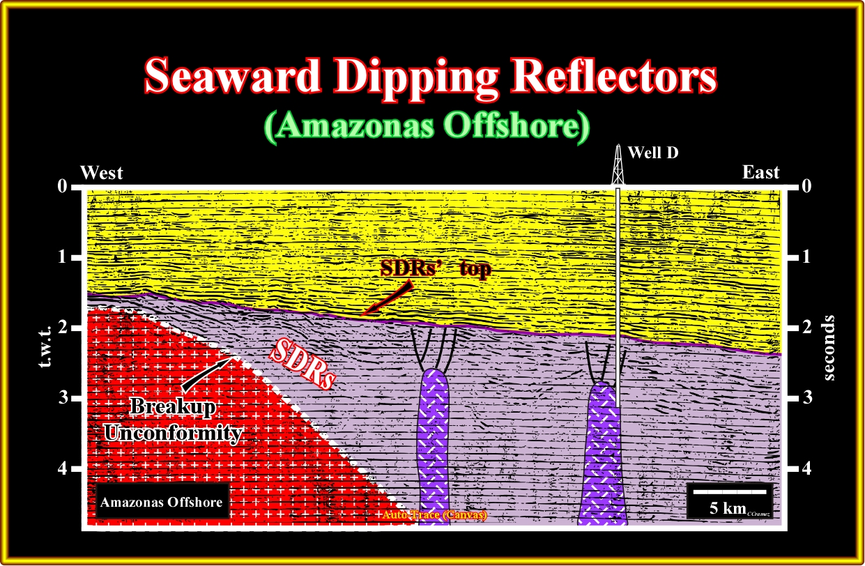
Plate A16.03- After drilling, geoscientist had not problem to considered the lower part of the well as deformed SDRs. The seaward dipping geometry was, in the central and eastern part of the line, deformed by volcanic plugs. A volcanic plug, also called a volcanic neck or lava neck, is a volcanic land-form created when magma hardens within a vent on an active volcano. It is important do not forget that when forming, a plug can cause an extreme build-up of pressure if volatile-charged magma is trapped beneath it, and this can sometimes lead to an explosive eruption.
to continue press
next

Send E-mails to carloscramez@gmail.com or to carlos.cramez@bluewin.ch with comments and suggestions to improve these geological notes.
Copyright © 2012 Ccramez, Switzerland
Last updated: July, 2014