Caveat:
These notes should not be taken as an attempt to write a textbook on the Atlantic-Type Divergent Margins. They are just an eclectic assemblage of geological models, cross-sections and tentative geological interpretations of auto-traces of more significant seismic lines used not only to test the "post-breakup salt hypothesis", proposed in 200o by Total SA's geoscientists (presently TotalEnergies) to explain the opening of South Atlantic, but to show that such hypothesis is corroborated in all Atlantic-type divergent margins associated with the breakup of the Gondwana Super-continent (southern continent of the Pangea) as well. The author is the only responsible by the proposed tentative geological interpretations, which, in reality, were done on the seismic lines and then overlain on the auto-traces. If you want contact me, please, send a E-mail to carlos.cramez@bluewin.ch or carloscramez@gmail.com.
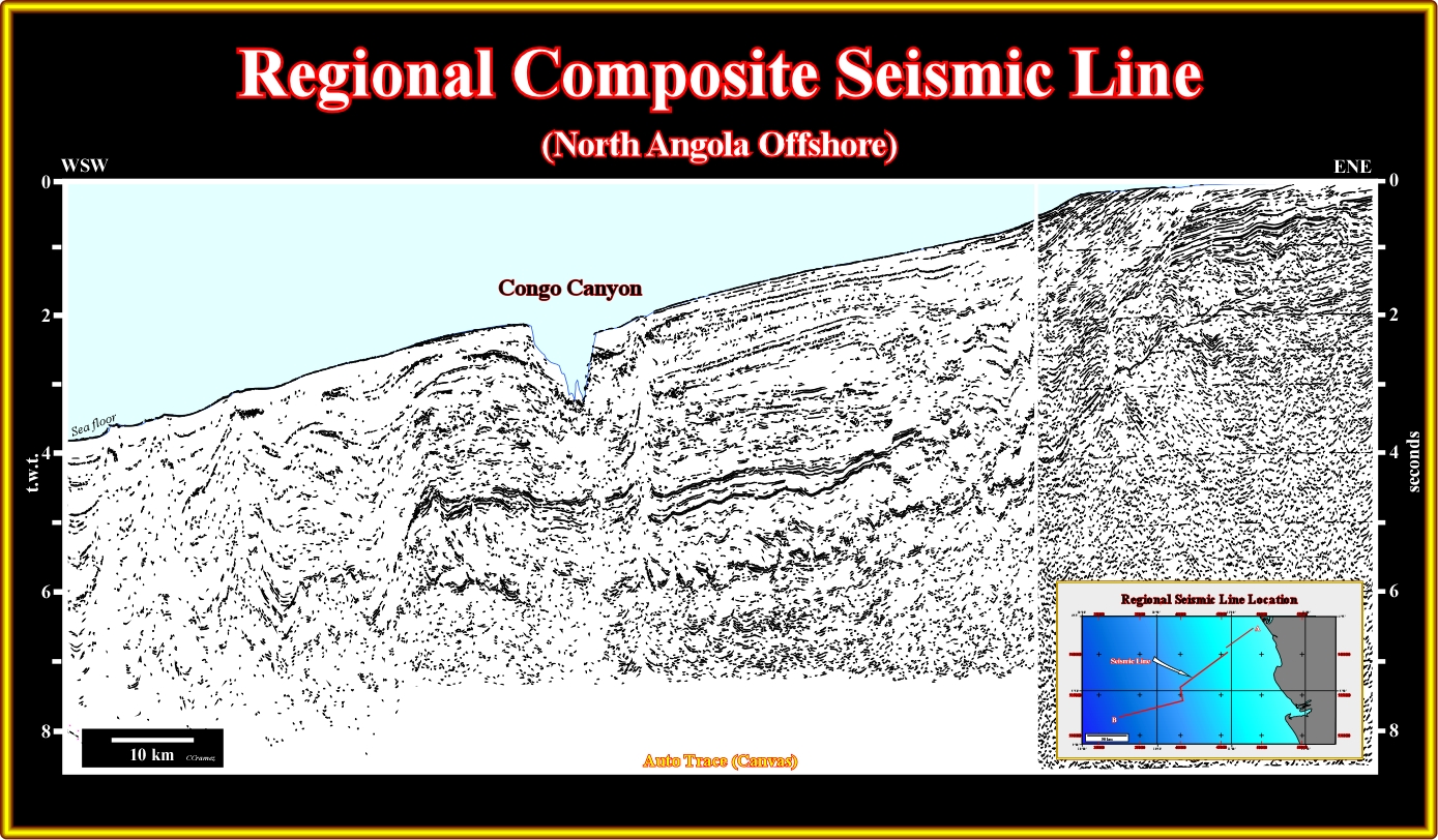
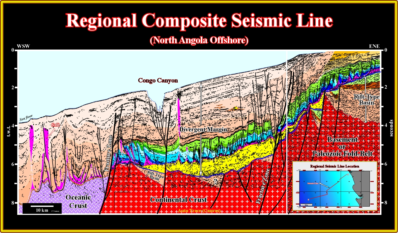
Plate 001- This plate does not illustrate a composite seismic line of Angola offshore, but a Canvas auto-trace of it. Due to confidential reasons, in these notes the original seismic lines will be not shown, but those already published in geological scientific papers. The majority of the illustrated plates are visual representation of seismic lines made by auto tracing (Canvas) or by pencil lines underlining the more significant seismic reflectors (chronostratigraphic reflectors). However, the proposed tentative geological interpretations, were done on the seismic lines and, then, overlain on the simulated lines, as shown in the next plate.
Plate 001A- This tentative geological interpretation of a composite seismic line of the offshore of the Congo geographic basin (North Angola offshore) illustrates a typical Atlantic-type divergent margin, in which, from bottom to top, different sedimentary basin types can be recognized : (i) Paleozoic fold belt or basement ; (ii) Rift-type basins pre-dating the breakup of the Pangea lithosphere and (iii) a Meso-Cenozoic Atlantic-type divergent margin. The infra-structure of the rift-type basins is always the continental crust (we don't know any rift-type basin developed within volcanic material, particularly in sub-aerial lava-flows). On the contrary, the infra-structure of the divergent margin is either the continental crust (proximal offshore) or volcanic crust (sub-aerial in the proximal areas and oceanic in the distal areas). The continental oceanic boundary (COB), i.e., the limit between the volcanic and continental crust is quite subtle due to the presence of an intermediated sub-aerial volcanic crust (SDRs), except when fracture zones put in, abruptly, juxtaposition the sialic continental crust with the volcanic (sub-aerial or oceanic), as it is the case in the western part of this tentative interpretation, which cuts two major fracture zones. The rift-type basins have a half-graben geometry and a quite sharp landward vergence with the in-filling sediments showing a, more or less, parallel internal configuration dipping continentward. A thick infra-salt margin depocenter, post-dating the breakup of the Gondwana super-continent (the post-breakup unconformity in underlined by a blue undulated line) is, easily, recognized in the central area. The petroleum exploration of this offshore has been concentrated in the Tertiary sediments (in beige color), where exploration based on seismic amplitude anomalies bas been quite successful. Below the inversion level, where amplitude anomalies do not exist anymore, there are just one or two exploration wells, in spite of the fact of the presence of quite evident petroleum systems, probably, similar to those found in conventional offshore (block 3, 2, 1, etc.). A generating petroleum sub-system seems quite evident on the margin infra-salt depocenter (in yellow on this tentative interpretation), which compensates, in this area, the absence of prospective rift-type basins (too small to allow the development of organic rich lacustrine shales, as it is the case in eastern part of this composite line). By the same token, one can say that several migration-entrapment petroleum sub-systems area, likely, on the Cretaceous carbonates and infra-salt sediments.
Contents:
I - Definition of Atlantic-type Divergent Margin
III - Conventional Models
IV - Seismic Examples (testing)
A5- Brazil (Cabo Frio Offshore)
A7- Brazil (Espirito Santo Offshore)
A9- Brazil (Sergipe Alagoas Offshore)
A10- Brazil (Pernambuco Parnaíba Offshore)
A11- Brazil (Potiguar Offshore)
A13- Brazil (Piauí Ceará Offshore)
A14- Brazil (Barreirinhas Offshore)
A15- Brazil (Pará Maranhão Offshore)
A19- USA Offshore (Gulf of Mexico)
A20- USA Offshore (Virginia Offshore)
A21- USA Offshore (Baltimore Canyon)
A22- Canada Offshore (Nova Scotia Offshore)
A23- Canada Offshore (Labrador Sea)
A24- Canada Offshore (Baffin Bay Offshore)
A25- Denmark Offshore (West Greenland Offshore)
A26- Denmark Offshore (East Greenland Offshore)
A27- Norway Offshore (Lofotens Offshore)
A28- Norway Offshore (South Lofotens Offshore)
A29- Norway Offshore (Voring Plateau)
A30- UK Offshore (West Shetlands)
A31- UK Offshore (Rockwall Trough)
A32- UK Offshore (Porcupine Basin)
A33- France Offshore (Armorican Offshore)
A34- Spain-France Offshore (Biscay Bay)
A35- Spain Offshore (Galicia Offshore)
A36- Portugal Offshore (Lusitania & Alentejo Basins)
A45- Equatorial Guinea Offshore
A48- Congo-Angola Offshore (Congo Basin)
A49- Angola Offshore (Kwanza Basin)
A57- North Australia Offshore (Kaitanimbar)
A61- Antarctic Offshore
V - Bibliography
to continue press

Send E-mails to carloscramez@gmail.com or to carlos.cramez@bluewin.ch with comments and suggestions to improve these geological notes.
Copyright © 2012 Ccramez, Switzerland
Last updated: July, 2014