Caveat
For confidentiality reasons, the majority of original seismic lines were replaced by auto-traces. They were vectorized, automatically, using the CanvasDraw 6 software or by hand. In the hand-made auto-traces, just the seismic reflectors, induced by the most important and significant geological events, were traced in continuity, what is not the case in automatic auto-traces. Canvas auto-tracing is much faster than tracing an image by hand or with the polygon or curve tool, although we need to edit the resulting vector paths. If you have any questions, please contact carlos.cramez@bluewin.ch or carloscramez@gmail.com
Preface
On tentative geological interpretations of seismic lines or their auto-traces, "Theory precedes Observation" (K. Popper, 1934). If a geoscientist in charge of the tentative geological interpretation doesn't not know what is a lava delta or a rift-type basin, he can spend hours looking at the auto-trace or at the original seismic line, but he never recognize them. A geoscientist just recognizes, in the field or on seismic lines, what he knows or what he expect to find. In stratigraphy, as well as, in sequential stratigraphy (seismostratigraphy when done on seismic lines), the word sandstone or submarine basin floor fans (acronym SBFF) is not by itself a sandstone or a submarine basin floor fans. By the same token, a sequential depositional stratigraphic model, as the one proposed by P. Vail (1977), should not be mistaken as the reality. It is just an incomplete virtual reality. In addition, as the vertical scale of the seismic lines is in time and the horizontal scale is metric, the geological reality is , even more, deformed. Seismic lines and geological models are not to be confused with real things they try to represents. “Being” and “Representing” are not the same (Wyn, C. M. & Wiggins, A.W.,1997). The idea that, in Geology, observations are the facts upon which scientific hypotheses are based was falsified since longtime. The majority of geological hypotheses are formulated "a priori" in order to explain problems raised by observations. Geological hypotheses cannot be built from a collection of detailed geological observations using an inductive approach (Popper, K., 1981). The same thing goes with the tentative geological interpretation of seismic lines. If a geoscientist knows the regional and global geological context of the Kwanza geographic basin, for instance, and the main geological models, he will interpret, easy, but tentatively, in geological terms, the Canvas auto-trace illustrated in figure 001.
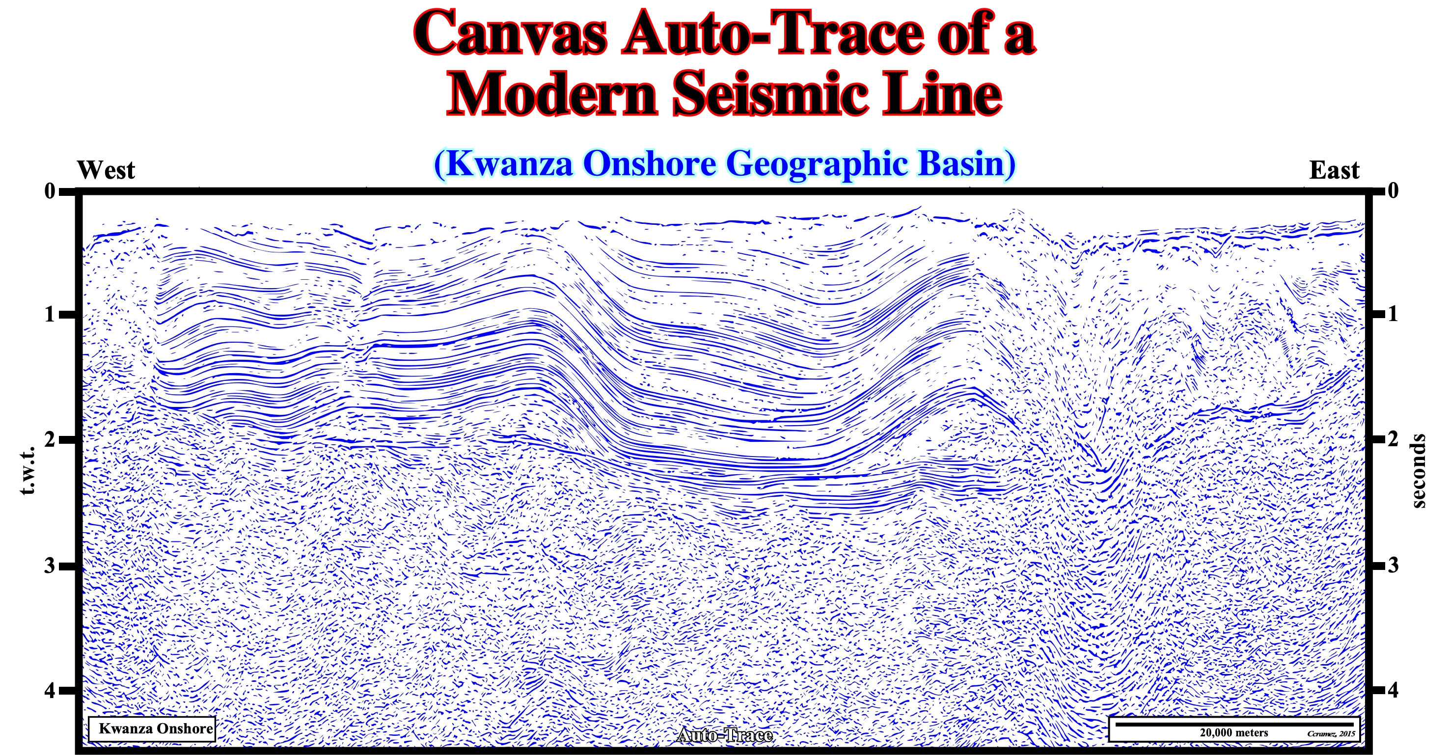
Figure 001- Contrariwise to a sedimentary basin, a geographic basin has no geological meaning. The first is a low land area of the Earth’s crust, usually, of tectonic origin. It has variable geometry, with a circular to linear form, in which sediments are deposited thickening toward the deepest and central part with an higher subsidence. The second is just an administrative division of an offshore or offshore, in which sedimentary basins were deposited over time. The onshore of Kwanza geographic basin, here illustrated by a Canvas autotrace* of a regional seismic line, is just the area in the Angola onshore, crossed by the Kwanza river, where several sedimentary basins were deposited. This Canvas auto-trace can be, easily, interpreted in terms of sedimentary basins, if the geoscientist, in charge of interpretation, knows the Bally & Snelson classification of sedimentary basins (1980). This basins' classification, based on the realms of subsidence, allows him to expect, in advance, what sedimentary basins and geological events** he must recognize. From bottom to top, he can, easily, recognized: (i) A Precambrian or Paleozoic Fold Belt ; (ii) Late Jurassic/Lower Cretaceous Rift-Type Basins and (iii) A Mesozoic-Cenozoic Divergent Continental Margin (Atlantic-Type). By the same token, in terms of geological events, he can easy individualizes: (1) The formation of rift-type basins ; (2) The break-up unconformity of the Pangea supercontinent ; (3) The deposition of lava flows, infra-salt margin sediments, allochthonous salt and the salt overburden. In addition, he can, easily, be fully aware of the halokinesis, Late-Tertiary uplift, etc, etc.
** A Canvas auto-trace (Graphic Design And Technical Illustration Software) creates vectors from an image. Canvas auto-tracing is much faster than tracing an image by hand or with the polygon or curve tool, although you might need to edit the resulting vector paths. An important difference between a manual and Canvas auto-trace is that in a manual auto-trace the geoscientist just vectorizes the seismic events with a geological meaning, which is not the case in an automatic auto-trace.
** Geology is not a set of geological things, but a set of geological events. Geological things or geological objects continue over time. Geological events are of limited duration.
The concept of geological model varies within a wide range of meanings. In Geology, a lot of words are used as synonyms of geological model that geoscientists (Earth' scientists) built, sometimes, in mathematic language, to represent the geological reality. They trying to encode geological observations to, afterward, advance predictions. Geological observations have their own scope of meanings. They range from observations made by naive geoscientists (inductivists) to observations made by rationalist or critic geoscientists. The first ones ignore the geological context. They think theories can harm observations (tabula rasa, F. Bacon, 1620, 1986). The second ones, not only know what they must look for, but they are aware of most likely geological models as well. For most geoscientists there are not pure geological observations, that is to say, there are no observations without an important theoretical component. All geological or geophysical observations are interpretations of facts in the light of one or another theory. They are theory-laden.
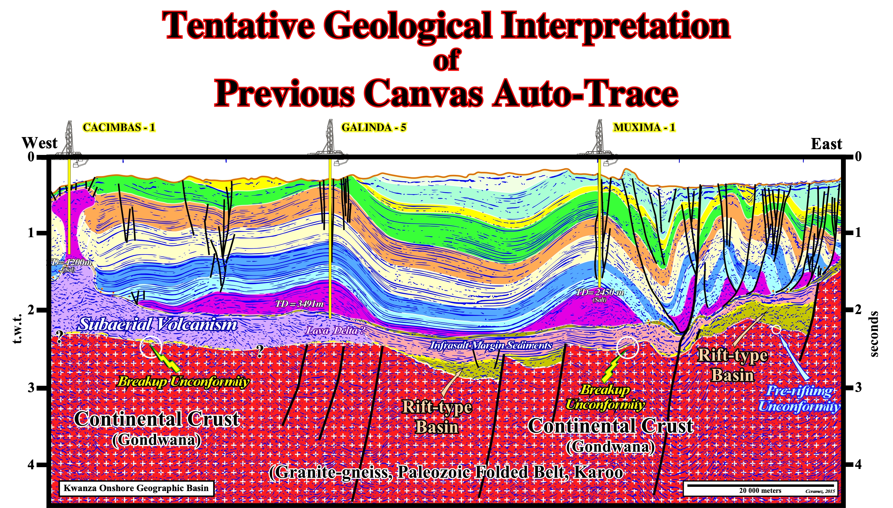
Figure 002- This tentative geological interpretation* of the previous Canvas auto-trace (figure 001) does not falsify the following geological conjectures: (i) Rift-type basins predate the break-up unconformity, which underlines the rupture of the Gondwana small supercontinent ; (ii) The size of the rift-type basins seems to be too small to develop lacustrine environments ; (iii) Near the break-up zone, there is deposition of lava flows postdating the break-up unconformity ; (iv) The lava flows can cover the more distal rift-type basins ; (v) Infra-salt margin sediments fossilize the rift-type basins and, locally, the lava flows ; (vi) Infra-salt margin sediments can form significant depocenters of organic rich lacustrine sediments (potential lacustrine source-rock intervals). The Kwanza geographic basin (onshore and offshore), obviously, is a stacking of various types of sedimentary basins (A. Bally and Snelson, 1980, see figure 003): a) A Precambrian substratum of granitic rocks or a Precambrian/Paleozoic folded belt forms the basement in which, locally, Karoo sediments (set of sedimentary units, particularly, of non-marine origin, deposited between the Late Carboniferous ant Early Jurassic) can be found; b) Late Jurassic/Early Cretaceous rift-type basins and c) An Atlantic-type divergent margin. The type-rift basins were formed during the stretching of the Gondwana lithosphere. They predated the break-up of the lithosphere. The break-up was made, primarily, by injection of mantle material that, progressively, became predominant individualizing the lithospheric plates of South America and Africa. The break-up of the lithosphere is underlined by a major unconformity, called break-up unconformity (acronym BUU), which on this tentative interpretation is colored in yellow. Since the break-up took place, the South America and Africa plates suffered a significant lateral accretion by a stacking of lava flows (SDRs = Seaward Dipping Reflectors) spreading from the expansion centers towards the cratons. The deposition of infra-salt margin sediments reached, locally, significant thickness (development of lacustrine organic rich depocenters). A thick evaporitic interval was deposited in Aptian. Above the evaporitic interval were deposited the retrogradational sediments of the transgressive phase of the post-Pangea continental encroachment cycle. Above the transgressive sediments were deposited the progradational sediments of the regressive phase of the continental encroachment cycle, which fossilized the Cretaceous maximum transgressive surface (top of transgressive phase).
* Another tentative geological interpretation of this Canvas auto-trace is proposed later, assuming the bottom of the salt (salt induced tectonic disharmony), works as a detachment surface allowing the cover (salt + overburden) to be lengthening up-dip and shortened down-dip, due to the opposition of the lava flow anomalies to the seaward movement of the cover.
In geological parlance an observation is a memory trace left in the geoscientist brain, when the outside world is imprinted on it (image or internal mental representation) through its sensory channels of sight, hearing, touch etc. Geoscientists see with the brain not with their eyes. When a geoscientist looks at a tentative geological interpretation of a seismic line, electromagnetic waves in the form of white light illuminates the tentative. Part of the white light is absorbed and part reflected. Specific wavelengths enter the eye, stimulated retinal cells, cause complex chemical and electrical changes in the geoscientist's brain and end up at the visual center at rear of his brain. So, the geoscientist sees with his brain an internal representation of the tentative interpretation and not the reality. In addition, the clean seismic line itself represents, in time, a defective copy of the reality.
In a scientific geological approach, an observation is always made in the context of a geological model and a model is created in the scope of an observation strategy. The rotation of this cycle (redundancy) increases the conformity of model and the quality of the observations, and thus the understanding of Geology. In fact, rather than simply describe all geological events by a simple process of cataloging or "stamp collection", models and simulations show the global mechanisms. "Observation of details can be interesting and fascinating, but we learn from Generalities," (P. Bak, 1996).
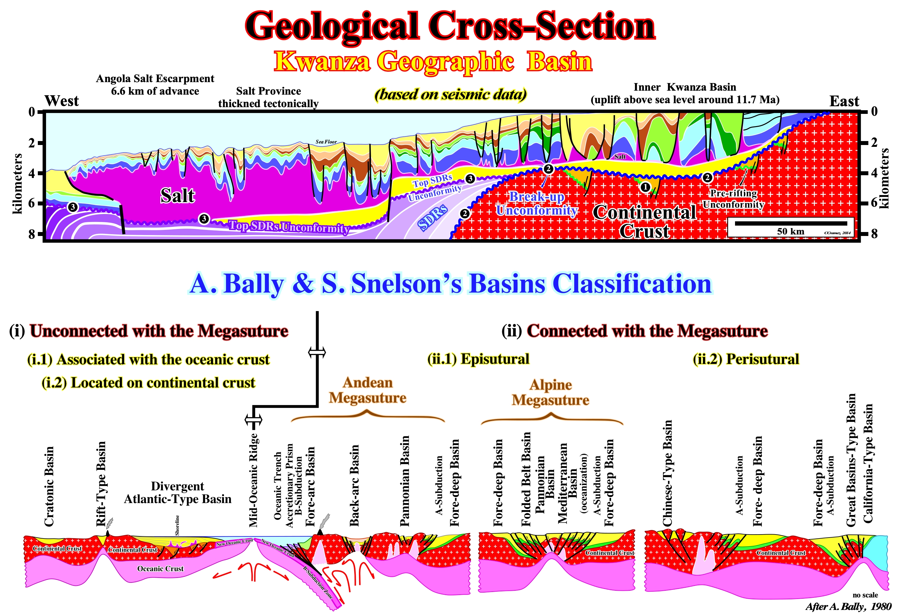
Figure 003- In the upper part of this figure is illustrated a geological cross-section of the Kwanza geographic basin (assumptions will be criticized later), which corresponds to the stacking of different sedimentary basins of the A. Bally & S. Snelson's basins classification. This classification, depicted in the lower part of the figure, recognizes two major types of sedimentary basins: (i) Basins not associated with the formation of the Mesozoic/Cenozoic megasuture and (ii) Basins associated with the formation of Mesozoic/Cenozoic megasuture. In the former ones, there are three main classes: (a) Cratonic basins, which developed on the Paleozoic continental crust, were, generally, created by a regional thermal subsidence ; (b) Rift-type basins, which are, generally, created on the Paleozoic continental crust by a differential subsidence, when the lithosphere is, locally, lengthened and (c) Divergent Atlantic-type margins, developed above the rift-type basins, in association with a thermal subsidence, postdating the break-up of the lithosphere of the Pangea supercontinent. Rift-type basins are, usually, covered either a cratonic basin or by a divergent margin. In the sedimentary basins associated with the formation of the Mesozoic/Cenozoic megasuture there are two large families: (1) Perisutural basins, which develop at the periphery of the megasuture, in association with a B-type (Benioff) or an A-type (Ampferer), as fore-deep basins (foreland basins) and fore-arc basins, and (2) Episutural basins, which develop within the megasuture (back-arc basins, Mediterranean-type basins and Pannonian-type basins). The lengthening behind the volcanic arc can be very important and create an oceanization (break-up of the lithosphere with formation of a marginal sea over a new oceanic crust, in which divergent non-Atlantic margins develop). Atlantic-type divergent margins are developed in a tectonic context, globally, compressional (sedimentary shortening) within the megasuture. Non Atlantic-type divergent margins are formed in an extensional context outside of the megasuture (sedimentary lengthening). This classification can, of course, be used for the Paleozoic basins just replacing the Pangea by the Proto-Pangea (Rodhinia) supercontinent and the Mesozoic/Cenozoic megasuture by the Paleozoic megasuture. Taking into account the geological time, a given area may correspond to the stacking of different sedimentary basins. The Angola offshore, for instance, from bottom to top, corresponds to the stacking of: (i) A more or less flattened Paleozoic mountain folded belt or a Precambrian basement ; (ii) Late Jurassic/Early Cretaceous rift-type basins and (iii) A divergent Atlantic-type margin deposited since the Early Cretaceous until today. In the divergent margin two tectono-sedimentary phases can be evidenced: a) A transgressive phase with a characteristic retrogradational geometry and b) A regressive phase, with a well-marked progradational geometry. Taking into account the geometry of these phases, a major downlap surface exist between them. This basins classification, like all other classification does not predict the volume of hydrocarbons generated and preserved in the different sedimentary basin families. However, it allows and, to a certain extent, it obliges the geoscientists in charge of petroleum exploration to make geological observations based and controlled by plate tectonics theory, which, presently, is the basis of all progress in the geology and success of oil exploration. It allows, in particular, a better evaluation of the different petroleum parameters (1) Source-rock ; 2) Reservoir-rock ; 3) Trapping ; 4) Migration and 5) Retention, which form the potential petroleum systems and quickly highlight the key parameter, which at the petroleum exploration point of view, can "kill" a basin or a petroleum prospect.