

Introduction
In the beginning of this workshop, we will focus, mainly, on the rational scientific method of Natural Sciences. We will try show how it can applied to approach the evaluation of the remnant petroleum potential of Kwanza onshore geographic basin, in which no oil exploration work (drilling) was done since 1972. Tentative geological interpretations of some new seismic lines shot, recently (2012), by Sonangol, will be used as experimental refutation tests for the geological hypotheses and conjectures proposed by different geoscientists to solve the geological and petroleum problems of the area. The old seismic lines shot by Petrangol (Petrofina) and Total CAP (Compagnie Française des Pétroles, now Total S.A.), the only oil companies that have worked in this geographic basin since the World War II, are unappropriated for a critical discussion of the invoked geological hypotheses and geoscientists' expectations. They are of poor quality, unmigrated and difficult to interpret, as illustrated in the figure 004.
In the second part of this workshop, we will review, briefly, the main conceptual hypotheses in sequential stratigraphy, depositional models, tectonics, halokinesis, fault picking, fault and salt induced seismic artifacts (pitfalls) in geological interpretation of seismic data.
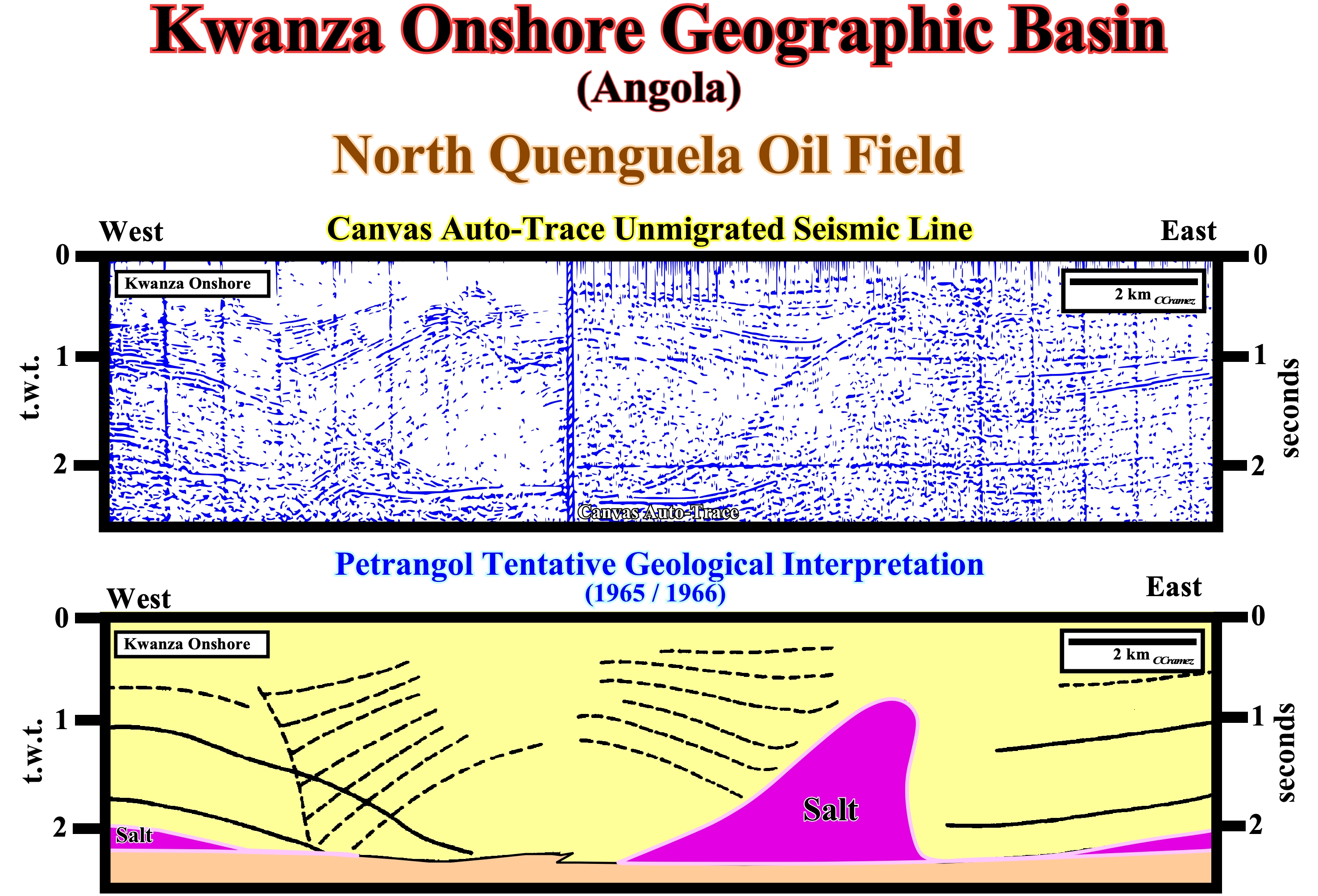
Figure 004- This tentative geological interpretation of an Angola onshore seismic line (Kwanza geographic basin) shot in the sixties (unmigrated seismic line), is, roughly, the same as the one proposed, in 1965/1966, by Petrangol geoscientists (Petrofina subsidiary), before North Quenguela oil field discovery, in 1967 (± 200 Mbbls, in situ, and ± 40 recoverable Mbbls of oil). As illustrated, the geoscientists, in charge of geological interpretation of the seismic lines, followed, just, the more or less continuous seismic reflectors to highlight bell-shaped structures (potential hydrocarbon traps). At that time, petroleum exploration was, mainly, based in the structural theory of oil occurrence* (oil trapped in anticlines). Sinclair's geoscientists, that worked in Kwanza geographic basin, between 1904 and 1922, found out significant lateral variations of the thickness of the geological formation, that they could not explain. In the 60s, Petrangol's geoscientists, having recognized, by drilling, the presence of a significant salt layer, advanced the hypothesis that the bell-shaped structures and the lateral thickness variations of certain geological formations, observed in the field and on the seismic lines, could be induced by salt flowage. The salt does not outcrop, in this geographic basin, but it was quickly found by drilling. Brognon & Verrier (1966) and later Masson (1972) explained the structure illustrated on this tentative interpretation (North Quenguela) with a minimum elongation (absence of tectonic stress, σt= 0) and maximum of salt reduction (flowage). In the 90's, Duval, Cramez and Jackson (1992), taking into account the significant shortening of the sediments, observed on seismic lines shot in the deep offshore, have proposed a different geological model, based on a maximum elongation and a minimum reduction salt. Locally, i.e, forgetting regional geologic context, it can be said: (i) The Quenguela structure is an antiform (not an anticline) ; (ii) The thickness variations of Miocene sediments and the absence of Cretaceous sediments in the core of antiform may be explained by both models. However, taking into account the regional geological context, the compressional structures observed in the deep parts of the offshore are, undoubtedly, a consequence of sedimentary lengthening (extension) observed in internal and proximal part of Angola offshore. The model proposed by Petrangol geoscientists was not corroborated, but falsified by the presence of a large folded belt in the deep offshore.
* In the 80's, such a geological conjecture was falsified. In Angola onshore and offshore, the large majority of bell-shaped structures are not anticlines (shortened structures), but antiforms (lengthened structures). Said in other words, the large majority of the petroleum traps are morphological by juxtaposition and not structural traps (four-way-dips).
It is good to call back at beginning this workshop one of the main messages of Sir K. Popper (1963) regarding the scientific method in Natural Sciences :
" The main mistake concerning the Natural Science is the belief that Science part from observation and collection of data or facts or measures and then proceeds to connect them and relate each other and so arrives - somehow - to Generalizations and Theories. "
The job of geoscientist and, particularly, those in charge of the geological interpretation of the seismic lines, does not begin with the accumulation of data. They do not start by picking seismic horizons, but by formulating significant scientific problems that they should try to solve, which is much more interesting than a simple collection or accumulation of observations. For those who still think that "Observation precedes Theory", K. Popper, in one of his lectures made a very meaningful experiment. Arriving to the conference room and after said : -Good morning everybody- he sit down. Then, looking to the participants he said: "I will ask you to observe, here and now. I hope everyone is cooperating and watching". After, few minutes of a glacial silence, one of the participants said: - Sorry, Sir, what should we observe? The answer was immediate:
" You are, absolutely, right. To observe you must know, before, what you have to observe ".
The same happens when a geoscientist tries to make a tentative geological interpretation of a seismic line. He must to known, in advance, what is the problem he must, tentatively, solve. He must know what he should look for on the seismic lines. For that, the Bally & Snelson basins classification can help him a lot. Let's see an example.
Suppose an exploration's boss ask a junior geoscientist to interpret, in geological and petroleum exploration terms, a seismic grid shot in a given area of the Neunquen geographic basin (Argentina onshore), where he has never work. He will be very happy and without any fear of going to work in a new geographic basin, because his mind is not a "tabula rasa", but full of geological knowledge. He followed in the High School and University a lot of courses and, particularly, geological courses. Among other things, he learned that in the scientific method of Natural Sciences "Theory precedes Observation" and, probably, he also learned that sedimentary basins can be classified according the realm of subsidence. Knowing, the location of the Neunquen geographic basin and the Bally & Snelson sedimentary basins classification, which is based in the Plate Tectonics Theory (megasutures and realm of subsidence), the geoscientist, before starting the tentative geological interpretation of the seismic lines, can advance the following geological conjectures belonging to the "World 3" (K. Popper, in 1967, made the assumption of the three worlds: World 1, that of the objects and physique forces ; World 2, that of the mental states and the World 3, that of the theories and theoretical problems, which also includes the language, works of art and social political institutions).
(i) the Neunquen geographic basin is a stacking of Mesozoic perisutural and episutural basins, over a Paleozoic folded belt:
a) Lower Mesozoic back-arc basin and
b) Middle-Late Mesozoic fore-deep basin.(ii) In a back-arc basin, a rifting and a sag phase (cratonic) are, often, recognized ;
(iii) Potential lacustrine source-rocks exist in the half-grabens of the rifting phase and potential marine-deltaic source-rocks exist in the sag phase ;
(iv) The presence of fore-deep sediments favors the maturation of the organic matter of the potential source-rocks of the back-arc basin ;
(v) The occurrence of structural traps (four-way-dips) is, likely, in association with the formation of the Mesozoic/Cenozoic megasuture ;
(vi) The normal faults developed during the rifting phase will be reactivated, sooner or later, as reverse faults creating tectonic inversions, i.e., structural traps ;
(vii) If the organic matter of the potential source-rocks reached maturation, the age of the hydrocarbon migration must postdate the tectonic inversions (higher change to develop hydrocarbon accumulations) ;
(viii) If the hydrocarbon migration predates the tectonic inversion, you must look for non-structural traps (stratigraphic, morphological or morphological by juxtaposition).
Knowing all this a priori conjectures, the geoscientist can to start the tentative geological interpretation the seismic lines, in order to try to falsify the assumed conjectures. If he is not able to falsify them, i.e., to refute them, he has a certain changes to find an exploration prospect to propose to his boss.
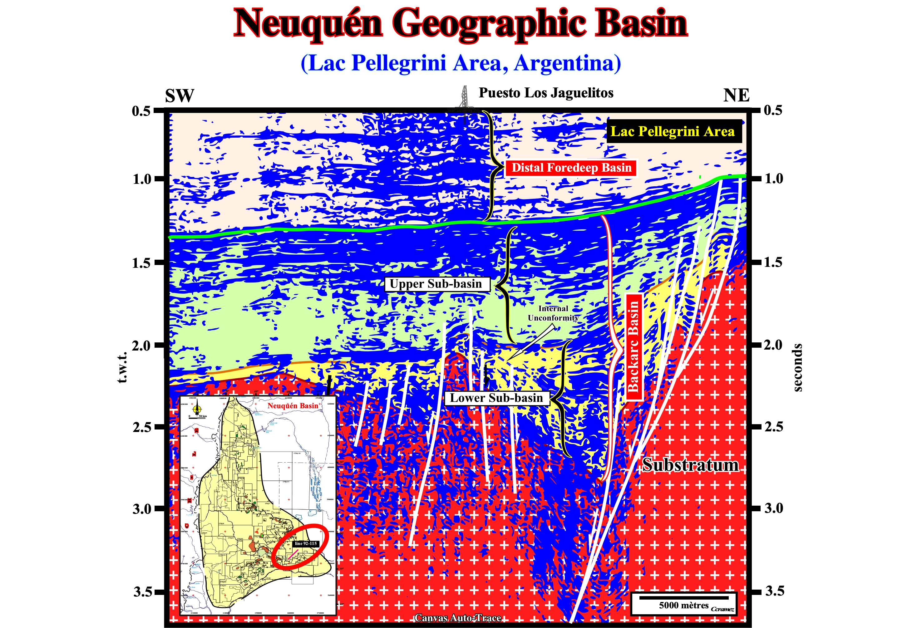
Figure 005- On this tentative geological interpretation of a seismic line of the Neuquen geographic basin (location map on the lower left corner of the figure), from the bottom to the top, a geoscientist knowing the geology of the area and the Bally’s basins classification, can easily recognized : (i) The Paleozoic lithosphere (southward of a line from Cordoba to Buenos Aires, the infrastructure of the Mesozoic/Cenozoic sediments is the Paleozoic megasuture and not the Precambrian Megasuture, as it the case northward) ; (ii) The lower sub-basin (rifting phase) of the back-arc basin, in which an important unconformity is suggested by an onlapping seismic surface defined by reflection terminations ; (iii) The upper sub-basin of the back-arc basin (sag or cratonic phase) and (iv) The distal part of the foredeep basin (eastern section). The geometry and internal configuration of the lower sub-basin of the back-arc basin, strongly, suggests a differential subsidence and volcano-clastic infilling below of the onlap seismic surface (unconformity) and lacustrine sediments above (potential lacustrine source-rocks). The internal configuration of the upper sub-basin of the back-arc suggests a thermal subsidence and sediments deposited in a shallow marine environment (platform sediments) some of which exhibit a clear progradational geometry suggesting the possibility of presence, side by side, of potential reservoir and source-rocks favoring the development of non-structural traps. The presence of fore-deep sediments in this area contributes, mainly, to the organic matter maturation of the potential source-rocks of the back-arc basin.
In the scientific method of K. Popper, seismic lines are not shot for geoscientists discover what is the scientific problem that they must solve, but to test or criticize the conjectures and assumptions they have advanced to solve the problem. This view of the scientific method can be summarized by four words (K. Popper (1963, 1964):
P1 →TT→EE→P2
(i) Problem (P1) - selection of a scientific problem ; (ii) Hypothesis (TT)- tentative solution to solve the problem, that is to say, the testing theory ; (iii) Critic or Test (EE)- critical discussion of the hypotheses advanced, i.e., elimination of error with evaluation ; (iv) New problem (P2) - a critical discussion of even the best hypotheses reveals, always, new problems.
The most common scientific problem for geoscientists working in petroleum exploration and, particularly, for those who are in charge of tentative geological interpretation of seismic lines is of course :
What is or what are the most likely petroleum systems in this geographic basin ?
Theoretically, the best way to solve the problem of the presence or absence of a petroleum system in a given sedimentary basin is, undoubtedly, the scientific PHT approach (Problem - Hypothesis - Test), which, takes into account the geological knowledge of the geoscientist. Such a problem can be solved in several stages. Each stage corresponding, always, to the resolution of a geological problem, by proposing, tentatively, a hypothesis or conjecture, which then is submitted to bold refutation tests. To find a solution to the above problem several subordinated geological problems must be solved:
1) How many sedimentary basins (Bally and Snelson's classification) exist in this geographic basin ?
This problem can be put in another way: The geographic basin corresponds to single sedimentary basin or to a stacking of different sedimentary basins? The answer to this question is of great significant. In stacking hypothesis, the generating and trapping petroleum sub-systems can be located different sedimentary basins, which pose additional problems. Assuming the answer is a stacking of different types of sedimentary basins, it raises a new problem (2).
2) What are the age of the different sedimentary basins ?
Are they Paleozoic, Mesozoic or Cenozoic ? The answer to this problem is important. The generating petroleum sub-system, i.e., the potential source-rocks and, particularly, the marine source-rocks are quite different, despite the fact, that their recognition, on the seismic lines, is the same (identification of the major downlap surface of the respective continental encroachment stratigraphic cycle). In the first case, the generating petroleum sub-system must be found in the post-Rodhinia (Precambrian supercontinent) continental encroachment cycle. In the second, it is must be found in the post-Pangea continental encroachment cycle. Assuming that the most likely hypothesis (the more difficult to refute) is Mesozoic/Cenozoic age, it puts a new problem (3).
3) What kind of subsidence induced each sedimentary basin ?
This question may be posed for each sedimentary basin, otherwise: Is the basin associated with the formation of a megasuture or with the formation of oceanic crust ?
- If basin is associated with the formation of a megasuture (back-arc, fore-arc, fold-belt, Pannonian or Mediterranean basins), the most likely traps are structural (four-way-dips closure).
- If the basin is associated with formation of new oceanic crust (rift-type, cratonic and divergent margin basins), the most likely traps are created by sedimentary lengthening (no-structural, stratigraphic, morphological or morphological by juxtaposition).
Let's suppose, for instance, that the hypothesis most difficult to falsify is that the concerned geographic basin corresponds to the stacking of two sedimentary basins associated with the formation of oceanic crust :
- Late Jurassic / Early Cretaceous rift-type basins created by a differential subsidence and
- Mesozoic-Cenozoic divergent margin Atlantic-type.This hypothesis creates two new problems (4) and (5).
4) What is the petroleum potential of the rift-type basin ?
The petroleum potential of a sedimentary basin is determined by the presence and quality of petroleum parameters, i.e., mainly, source-rock and maturation, reservoir-rock, trapping, migration and retention. The source-rock is a killer parameter. If a basin have no source-rock, the study of the other parameters is irrelevant. The probability of existence of a petroleum system is the product of the probability of existence of the different petroleum parameters. If the probability of existence of a parameter is zero (0), the existence probability of the petroleum system is zero (0). Today, the geological knowledge suggests :
- A rift-type basin corresponds to lengthening (extension) of the lithosphere of a supercontinent, which in our case is the Pangea, since the age of the rift-type basin is Late Jurassic/Early Cretaceous.
- A rift-type basin is bounded by two unconformities. At the base, the pre-rifting unconformity (predates the lengthening induced by a differential subsidence). At the top, the break-up unconformity (rupture of the supercontinent lithosphere), which marks the end of the lengthening and the beginning of the sinking (sag) induced by a thermal subsidence (divergent margin).
- A rift-type basin geometry is, generally, an half-graben with a divergent or parallel the internal configuration.
- The sediments thicken against the bordering normal fault, which, generally, dips in the direction of the lithosphere thickening.
- The infilling is, usually, syntectonic and non-marine. In certain cases, volcanic material is dominant. In others, the upper sediments are marine.
- In most rift-type basins, from bottom to top, a typical facies trilogy (lithology)is recognized :
(i) Sands and fluvial sandstones ;
(ii) Lacustrine shales, often, rich in organic matter ;- If the internal configuration of this interval interval is divergent toward bordering fault, probably, the shales are rich in clastic material and can not be considered as potential source-rocks. This hypothesis is plausible when the extension rate is compensated by the terrigeneous influx, i.e., when there is no development of a water depth or formation of a lake.
- If the internal configuration is parallel, the shales are, probability, rich in organic matter and they can be considered as potential source-rocks. This scenario is, likely, when the rate of extension is not compensated by the terrigeneous influx, i.e. a lake is created with a sufficient water depth for development of life and preservation of the dead organic matter when it reaches the bottom of the lake.
(iii) Alluvial fan sandstones.
- Reservoir-rocks are possible either in the alluvial fan sandstones or in fluvial sands. If the internal configuration is divergent toward the bordering normal fault, the thickness and the petrophysical qualities of the reservoir-rocks may be appropriate where the subsidence is more important (close to the fault). The reservoir-rocks pinchout and disappear updip, which can form potential stratigraphic traps (function of the hydrodynamism).
- If there is not a late compressive tectonic regime to reactivate the normal faults into reverse faults (which is rare in an Atlantic-type divergent margins, but quite common in non Atlantic-type divergent margins), the probability of structural traps in a rift-type basin is, almost, non-existent. Just non-structural traps, i.e., stratigraphic and morphological, particularly, morphological by juxtaposition (erroneously called, by many geoscientists, traps against fault) are likely. A fault never closes a reservoir-rock. What close is a sealing-rock in the other side of the fault in juxtaposition to the reservoir-rock or a clay gouge when present between the two faulted blocks.
5) What is the petroleum potential of the Atlantic-type divergent margin ?
Just as in 4), the geological knowledge (a priori hypotheses) suggests :
- When the thinned lithosphere of the supercontinent broke, due to the injection of mantelic material, two lithospheric plates individualized on each side of the break-up zone.
- The lithosphere cannot, anymore, length by normal faults. The formation and development of rift-type basins ended. An erosional surface (break-up unconformity) separates the rift-type basins from the overlying divergent margin.
- The lithosphere cannot, anymore, length by normal faults. The formation and development of rift-type basins ended. An erosional surface (break-up unconformity) separates the rift-type basins from the overlying divergent margin basin.
- On each side of the break-up zone due to the deposit of lava flows ejected from the sub-aerial expansion centers located along the fracture zone, he lithosphere begins to grow by accretion. Lava flows (sub-aerial by definition, since lava can not flow under water) are known, mainly, by drilling in all North and South Atlantic margin, except, probably, in Galicia and Portugal margins.
- As the lava flows were deposited between the sub-aerial spreading centers and the continental crust, small epicontinental seas or large lakes were formed, with potential reservoir-rocks (sandstone, lacustrine or shallow water limestones), as well as, potential source-rocks (lacustrine shales). These sediments, which, locally, may reach considerable thickness (depocenters) are, often, covered with a thick layer of salt rich in potassium which, strongly, suggests that the brines were hydrothermally enriched by a reaction between the water and the underlying volcanic material.
- Since the loading of successive lava flows submerged the expansion of centers, the sea level rose and encroached the divergent margins on each side of the break-up zone. The formation of oceanic crust starts since the volcanic material spewed by expansion centers (dike complex) is frozen in lava pillow, which form the top layer of the oceanic crust. Each injection of a dike (in the old dikes) along the break-up zone, acts as a feeder of the overlapping sequence of extrusive rocks and represents an increment of the seafloor expansion. This spreading and the formation of oceanic mountains (ocean ridges) decreases the volume of ocean basins, which, for an amount of water, in all its forms, constant since the formation of Earth (geological conjecture that has never been or have not yet been refuted ) causes an absolute sea level rise.
- This absolute (eustatic) sea level rise reached its acme in the Cenomanian - Turonian (MFS. 91.5 Ma). Afterward, the absolute sea level fall till today. The rising and falling of the absolute sea level formed the second Phanerozoic 1st order eustatic cycle. During this cycle was deposited the post-Pangea (Mesozoic-Cenozoic) continental encroachment cycle, which is represented, in our geographic basin, by the Atlantic-type divergent margin.
- Theoretically in a divergent margin one can recognized, at the base, a transgressive phase with retrogradational geometry, during which the sediments become more and marine and carbonated, which, progressively, form a continental shelf. The platform reaches its maximum extension at Cenomanian-Turonian, when the continental break is the farthermost from the coastal deposition break (more or less, equivalent to the shoreline).
- Since the Cenomanian - Turonian, the absolute sea level begins to fall (the volume of ocean basins increases due to the subduction of oceanic crust along the Benioff subduction zones), allowing the deposition of regressive phase of the continental encroachment cycle. The geometry of this phase is progradational. The depositional water-depth decreased, progressively, as the size of the continental shelf. At the same time, the depositional coastal break approached, progressively, the continental break until the margin became without shelf (no shelf basin).
- Significant global geological events occurred during this phase, in particular, the Antarctica ice cap formation, which caused a major absolute (eustatic) sea level fall, which is responsible for unconformity SB. 30 Ma, marking, roughly, the beginning of the Oligocene.
- Potential marine source-rocks are associated with the downlap surface, MFS. 91.5 Ma, separating the transgressive and regressive phases. Secondary marine source-rocks are possible but their petroleum potential is insignificant (except for the Kimmeridgian clays in the North Sea).
- Reservoir-rocks exist in the transgressive and regressive phases. In transgressive phase, carbonate reservoir-rocks are largely predominant. In the regressive phase the reservoir-rocks are, mainly, associated with turbidite systems.
- Morphological traps by juxtaposition are prevalent in transgressive phase, while in the regressive phase, stratigraphic traps (turbidites) and morphological by juxtaposition are the most frequent. Practically, there are no structural traps with economic value.
- In the margins, where a thick salt layer was deposited, halokinesis produces a lot of traps, but the majority is non-structural. The suprasalt sediments (overburden) are lengthened by halokinesis. Exceptions are rare.
Taking into account of all these conjectures, a new problem should be solved (6).
6) What are the potential petroleum systems in our geographic basin ?
Summing up: taking into account the known geological knowledge, the most likely petroleum systems are:
a) Lacustrine shales of the rift-type basins (source-rock)/sandstones of the rift-type basins (reservoir-rock) ;
b) Lacustrine shales of the rift-type basins (source-rock)/Carbonates of the transgressive da phase (reservoir-rock) ;
c) Lacustrine shales of the rift-type basins (source-rock)/Infrasalt margin sandstones (reservoir-rock) ;
d) Infra-salt margin lacustrine shales (source-rock)/Infra-salt margin sandstones/limestones (reservoir-rock) ;
e) Infra-salt margin lacustrine shales (source-rock)/Limestones of the transgressive phase (reservoir-rock) ;
f) MFS. 91.5 Ma marine shales (source-rock)/Limestones of the transgressive phase of the margin (reservoir-rock) ;
g) MFS. 91.5 Ma marine shales (source-rock)/Turbidites of the regressive phase of the margin (reservoir-rocks) ;Finally, all these assumptions and guesses must to be tested, i.e., they must be criticized by observations and experiment tests in order to try to falsifying them and not to corroborate them, which creates a new problem (7).
7) How to test the above hypotheses and conjectures ?
If our geographic basin is not covered by dense vegetation or thick alluvium, the best way to test the advanced hypotheses and conjectures is to make or interpret the geological map of the basin and sample the main sedimentary intervals in order to try to refute or corroborate the characteristics of the source and reservoir-rocks. A correct reading of the geological map will, certainly, highlight the principal traps. If this is the case, a final refutation test is to drill an exploration well. If the well find a hydrocarbon accumulation everyone will be happy, starting with the company's boss. However, at the scientific point of view, the geoscientists who worked on the project did progress, too much, since there was no refutation. Geological knowledge progresses when there is refutation, not when there is corroboration.
If our basin is largely covered by recent deposits that hide any type of outcrop, a seismic campaign is necessary to test the conjectures advanced above. This means, contrariwise to a widespread idea, among certain geoscientists, the geological interpretation of seismic lines is used to test, i.e., to try to refute the hypotheses proposed to solve the geological and not to put in evidence the potential petroleum systems.
Geoscientists needs to know what to observe. Similarly, to test something, they needs to know what they must test. If a geoscientist pretend to interpret, in geological terms, the seismic data, he must to know, a priori, what he must identify on the seismic data to test the proposed tentative solutions (hypotheses and conjectures).