Part One
(Scientic Model & Geological Problems)
Geological Setting of the Kwanza Geographic Basin
a) Congo, Kwanza & Benguela Geographic Basins
The Angola onshore and offshore is the result of the lengthening of the Gondwana small supercontinent and the subsequent opening of the South Atlantic. The median sector of the Angola coastal onshore and offshore corresponds to the Kwanza geographic basin, which is, geologically speaking, the stacking of several types of sedimentary basins of the A. Bally & S. Snelson basins classification (figure 003 & 006):
(i) Precambrian granitic rocks or a Paleozoic folded Belt ;
(ii) Late Jurassic/Early Cretaceous rift-type basins ;
(iii) A Mesozoic-Cenozoic Atlantic-type divergent margin basin.
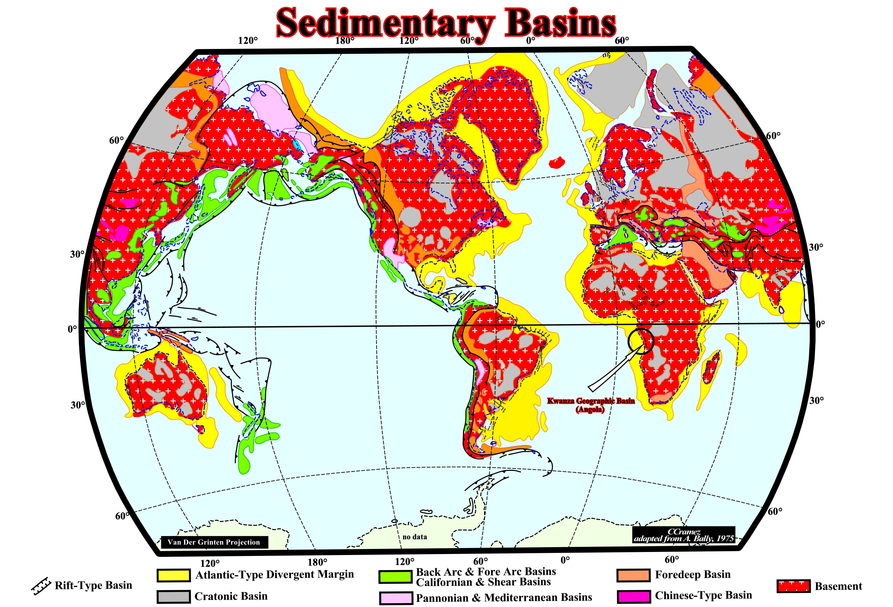
Figure 006- The mapped sedimentary basins correspond to those considered in the classification of sedimentary basins proposed by A. Bally and S. Snelson (1980), which is very useful for a critical discussion of petroleum problems. This classification is based on Plate Tectonics theory, particularly, on the mapping of the megasutures (Precambrian, Paleozoic and Meso-Cenozoic). If the considered megasuture is the Paleozoic megasuture, the basins will be Paleozoic, i.e., they postdate the Rodhinia's formation and predate the Pangea's formation. If the considered megasuture is the Mesozoic/Cenozoic megasuture, the basins postdate the Pangea's formation. There are two major classes of sedimentary basins : Class A, which includes the sedimentary basins not connected with the megasuture formation (figure 003) and Class B, which includes the basins connected with the megasuture formation. Class A includes the sedimentary basins located on rigid lithosphere and, relatively, undeformed not associated with the formation of a megasuture. Within class A, two sub-classes can be considered: A.1, associated with the formation of oceanic crust, as rift-type basins and Atlantic-type divergent margins basins and A.2, which embraces the basins located on the pre-Mesozoic continental lithosphere, as the cratonic basins. In Class B, i.e., in the basins associated with the formation of a megasuture, three sub-classes can be considered: (i) B.1 (perisutural basins) formed on the rigid lithosphere, which can be sub-divided into : (i.a) B.1.1 - Oceanic trenches associated with B-type subduction zones ; (i.b) B.1.2- Foredeep basins associated with A-type subduction zones ; (i.c) B.1.3 - Chinese-type basins (in violet, (ii) B.2 (episutural basins) associated with a B-type subduction zone, which are sub-divided in : (ii.a) B.2.1.1 (back-arc basins) and (ii.b) B.2.1.2 (fore-arc basins). Episutural basins (B.2), which are associated with A-type subduction zones, are sub-divided into : B.2.2.1 (pannonian-type basins) and B.2.2.2 (mediterranean-type basins). The basins associated with shearing (B.2.3), can be : B.2.3.1 (Great basin-type), B.2.3.2 (Californian-type) and (B.3) Folded belts, which can be : Associated with A-subduction zones (B.3.1) and associated with B-subduction zones (B.3.2).
Geographically, three main administrative or geographic basins are considered in the offshore and coastal onshore (figure 007). They are:
a) Congo Geographic Basin ;
b) Kwanza Geographic Basin and
c) Benguela Geographic Basin
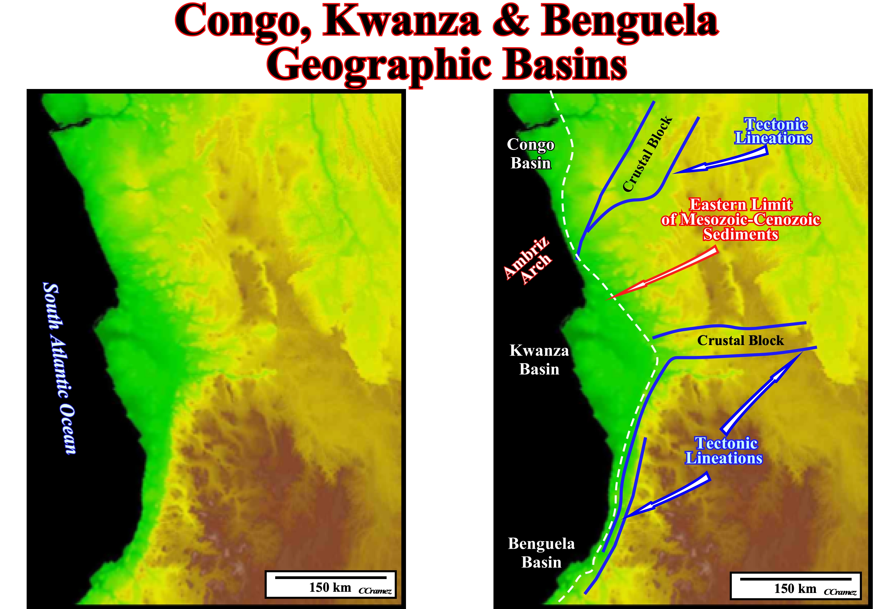
Figure 007- Taking into account the Eastern limit of Mesozoic-Cenozoic sediments, two important indentations are, easily, visible in the onshore Angola. The northern is crossed by the Congo River and it corresponds to what geoscientists call Congo geographic basin onshore. The southern indentation, which is more important, is crossed by the Kwanza river. It corresponds to the Kwanza geographic basin onshore. Between the two indentations, the basement, which, here, is formed by granite-gneiss often with with garnets, outcrops near the coastline. The Ambriz Arch (see later) is considered by many geoscientists as the limit between the Congo and Kwanza geographic basins. The Congo geographic basin can be divided in two sectors in relation to the Congo River: North and South Congo geographic basins. The Kwanza geographic basin, as we shall see later, can be divided into two sub-basins: (i) Inner Kwanza geographic basin and (ii) Outer Kwanza geographic basin. They are separated by a coastal arch. Roughly, the inner Kwanza geographic basin corresponds to the onshore (plus conventional offshore) and the outer Kwanza geographic basin to the deep offshore. The Benguela geographic basin, southward of the Kwanza geographic basin, is developed, mainly, in the offshore. The continentward limit of the Benguela basin seems to be tectonically controlled. Eastward of the coastal deposits, the topography of the basement and the tectonic lineations (fault traces, axis of folds, etc.) suggest not only the limit of the Benguela geographic basin, but the Kwanza geographic basin as well, were, partly, controlled and affected by the reactivation of the basement structural alignments. Some lineations in the basement (granite, metamorphic or sedimentary rocks) define, sometimes, characteristic geological bodies.
The substratum of the Kwanza geographic basin is formed by rocks of the Pangea supercontinent lithosphere. The rift-type basins, which are filled by clastics, were formed during the lengthening of Pangea supercontinent, before the break-up of the lithosphere. The divergent margin basin was formed after the break-up of the Pangea lithosphere in association with oceanic expansion and lateral migration of the individualized lithospheric plates.
b) Substratum of the Kwanza Geographic Basin
The substratum of the Kwanza geographic basin is the Gondwana lithosphere. It corresponds to a quite complex craton, composed by granitic, metamorphic and sedimentary rocks, which have been affected by compressional and extension tectonic regimes. Some of the fracture zones of this pre-fractured craton were reactivated, during the Mesozoic extension, controlling, partially, not only the formation of rift-type basins, but the break-up of the lithosphere and the evolution of the Mesozoic/Cenozoic divergent margin basin, as well.
Three pre-Pangea sedimentary basins (figure 010) formed in the Gondwana lithosphere, predate the Kwanza geographic basin. They area:
.a) Congo Geographic Basin ;
b) Kwanza Geographic Basin and
c) Benguela Geographic Basin
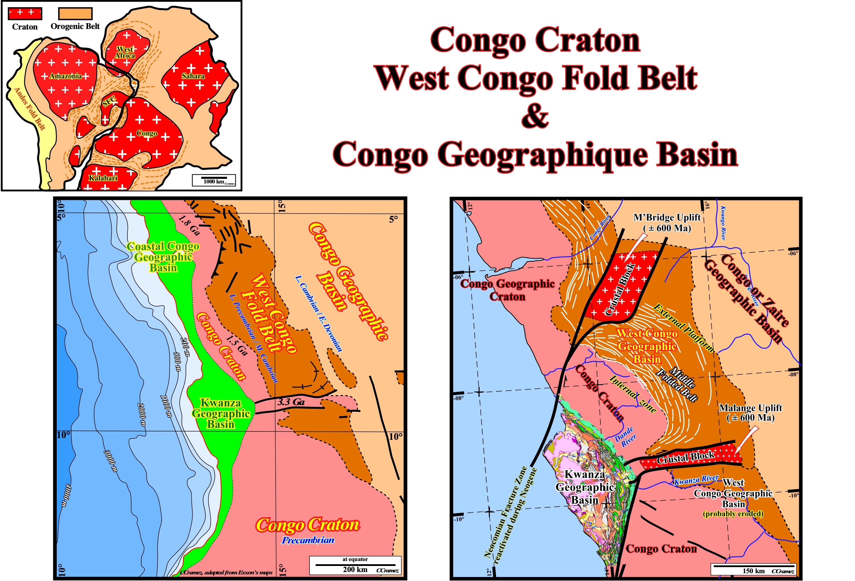
Figure 008- The Congo craton, which has nothing to see with the coastal Congo geographic basin, is a Precambrian craton which, with four others cratons (Kaapvaal, Zimbabwe, Tanzania and West African), forms the current African continent. The Congo craton outcrops in several areas. It is the adjacent and underlying basement of the Kwanza geographic basin. The West Congo Geographic Basin is a Late Precambrian/Middle Cambrian folded belt. It is named just West Congo Fold-Belt for several geoscientists. This fold belt was formed inside and above the Precambrian Congo craton. The West Congo Folded Belt resulted from a rifting, between 1,000 Ma and 912 Ma, along the western margin of the Congo craton. The rifting was followed by subsidence with deposition of carbonates deposition, between 900 and 570 Ma, including two glacial horizons very similar to those found in Katanga sequence of the Arch Lufilian arch (southern boundary of the Congo Craton). Later a compressional tectonic regime created the formation of a foredeep basin. The Congo geographic basin or Zaire geographic basin is a stacking of Late Cambrian/Early Devonian cratonic basins.
The Congo craton is an ancient Precambrian craton. It was formed between ± 3.5 and ± 2.0 Ga and stable since ± 2.0 Ga. The Congo craton is covered by Paleozoic to recent sediments of the Congo river geographic basin. As the other Africa Precambrian cratons ( Kaapval, Zimbabwe, Tanzania and West African) the Congo craton, is bounded by younger fold belts formed between 2.0 Ga and 300 Ma. Before the opening of the South Atlantic, the Congo craton was connected with the São Francisco craton (Brazil) by a bridge that certain geoscientist call Bahia–Gabon Bridge.
The West Congo Geographic Basin corresponds to a fold belt developed, in the eastern part of Congo craton, between 1,0 Ga and 541 Ma, following the deposition of around 4,000 meters of a passive margin sediments.
Congo (Zaire) Geographic Basin is a stacking of different sedimentary basins (mainly cratonic basins) deposited above the Congo craton, since the Late Cambrian till today.
A crustal block (2,800 Ma), striking West-East, outcrops in the southern part the West Congo folded belt (Figure 009). It was named Malange crustal block (Figure 008). In the northern area, another sub-surface (not outcropping) crustal block, probably, of the same age, seems to occur the middle of West Congo folded belt. This northern crustal block corresponds to the M'Bridge uplift, which took place about 600 Ma. The southern crustal block corresponds to Malange uplift, which occurred, more or less, at same time that the M'Bridge uplift. These blocks are limited by fracture zones. These fracture zones were reactivated several times, even during the deposit of the Kwanza geographic basin. Certain lineations (linear structural features within rocks either intersection lineations, crenulation lineations, mineral lineations or stretching lineations) and fracture zones discernible in the Kwanza geographic basin are just the result of the reactivation of Precambrian fracture lines, as illustrated in figure 008 and 009.
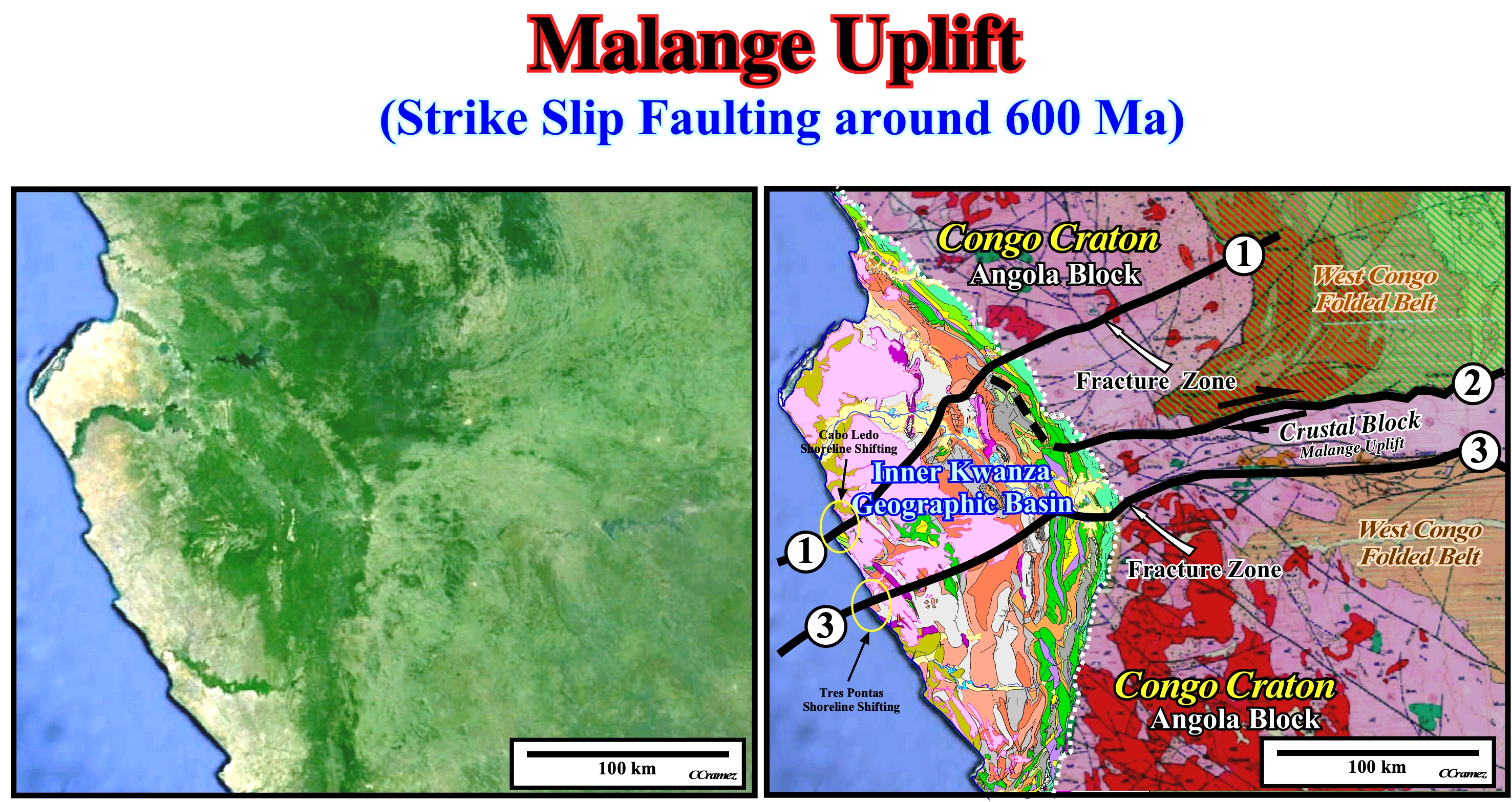
Figure 009- In the left (Google Map), the eastern limit of the Kwanza geographic basin is, easy, to follow. Similarly, the fracture zones bordering the Malange crustal block (Malange uplift) are recognized without great difficulty, as well as, the lineations induced by structures of West Congo folded belt. Other lineations are discernible, particularly, (1), (2) and (3) fractured zones mapped on the composite geological map showed on the right. These fracture zones were induced by a regional extensional tectonic regime characterized by an effective stresses ellipsoid characterized by a σ1 vertical and a σ2 horizontal striking NE-SW. These fractures zones, as many others, of the Congo Craton were reactivated during the deposition of the Kwanza geographic basin. Different geological provinces, limited by these reactivated fracture zones, can be put in evidence. All provinces have suffered different spatial and temporal uplifts. Currently, they have different tectonic dips and different characteristic petroleum system (see later). The conjecture that dextral deviations of the shoreline mark, in surface, the trace of the reactivated fracture zones the Precambrian basement, is not refuted by these maps. The Cabo Ledo shoreline shifting corresponds to a reactivation, whether in compression or extension of the fracture zone (1) and the Tres Pontas shoreline shifting is associated with fracture line (3). Similarly, the eastern limit of the Kwanza geographic and the displacement of the antiform and depocenter structures (see later) suggest a reactivation of the basement structural lineations, which seems to have a significant influence on the evolution and geometry of the Kwanza geographic basin.
At the end of Proterozoic, more or less, 540 Ma, several mountain ranges were found in the Gondwana small supercontinent. Most of them are interpreted as fold belts, around the old cratons (West Africa, Sahara, Arabia, Amazonas, San Francisco, River Plate, Kalahari, Congo, Antarctica, Australia and West India). They were formed as a result of the closure of Proterozoic oceans. One of these fold belts, that is to say, the West Congo fold belt (West of Congo craton), is, for us, particularly interesting. It is, if not eroded, a portion of the substratum of the inner Kwanza basin.
The structures of the West Congo fold belt are compressive with a well marked eastward vergence (dip westward), thrusting in the Congo craton (covered by the Congo or Zaire geographic basin). The sediments suffered a moderate to low-grade metamorphism and they are associated with dextral and sinistral strike-slip shear. Eastward, an allochthonous stacking of faulted-folds of Paleo-Mesoproterozoic basement rocks rides the foredeep of the West Congo. The Congo folded belt forms the eastern part of an orogenic system. The western part, including ophiolites (800 Ma), outcrops in the Araçuai belt, in Brazil. The basement, i.e., the Congo Craton has a Precambrian age. It was formed between 3.6 and 2.0 Ga (giga = 109) as a consequence of the agglutination of various geological blocks.
Since its formation, the Congo craton is, more or less, stable. Among its geological blocks, the Angola block (figure 009) interests us particularly. At the Mesozoic, it formed, in large part, the infrastructure of the Kwanza basin. Currently it outcrops in the eastern part, as shown in the figure 009. The Angola block comprises a magmatic complex of orthogneiss and meta-sedimentary complex of quartzite and shale. At about 2.8-2.7 Ga, it was affected by a granulite facies metamorphism (great depth, high pressure and temperature and absence of water).
In the southern part of the complex (northward of Namibia), the rocks are protholiths with age ranging from Neoarchean (2.8 - 2.6 Ga) to Early Proterozoic (Siderian, 2.6-2.4 Ga). The were affected by migmatization*, between 2.29 and 1.85 Ga, with granitoid intrusions dated, in southern Angola (2,038 ± 28 and 1,959 ± 6 Ma) and Namibia (1,985-1960 Ma). After these events, a sedimentation phase took place with the deposit of Chela Group (nothing to do with Chela of Cabinda or Meso-Cenozoic south Congo geographic basin), in which an ignimbrite (debris acid lava from a pyroclastic flow, welded before cooling and and blended to a glass matrix) with zircon dated 1790 ± 17 Ma.
* Migmatization (ultrametamorphism) is a kind of geological process and diagenesis between the metamorphism and magmatism with the greatest characteristic of partial remelting and diverse fluid ( Unconventional Petroleum Geology, 2013).
c) Opening of South Atlantic
Before making a thorough examination of the South Atlantic opening model, proposed in the late 90s, by Total's geoscientists in collaboration with M. Jackson of Bureau of Economic Geology (Austin University, Texas), it is important to summarize and depict, here below, the main sedimentary and tectonic events characterizing the associated diverging margins.
c.1) Sedimentary & Tectonic Events
The main sedimentary and tectonic events associated with the opening of South Atlantic Ocean are:
- Agglutination of the Pangea Supercontinent (basement & Paleozoic sediments) ;
- Pre-Rifting Unconformity (PRU unconformity) with beginning of the Pangea lengthening;
- Thinning of the continental crust with emplacement of mantle dyke intrusions ;
- Pangea lengthening with formation of rift-type basins;
- Break-up of the Pangea lithosphere with formation of the BUU unconformity (break-up Unconformity) ;
- Emplacement of sub-aerial volcanism with formation of SU unconformity (top SDRs unconformity) ;
- Deposition of infra-salt margin sediments ;
- Deposition of potash evaporites, hydrothermally enriched (salt) ;
- Transgressive phase of the post-Pangea continental encroachment cycle ;
- Regressive phase of the post-Pangea continental encroachment cycle.
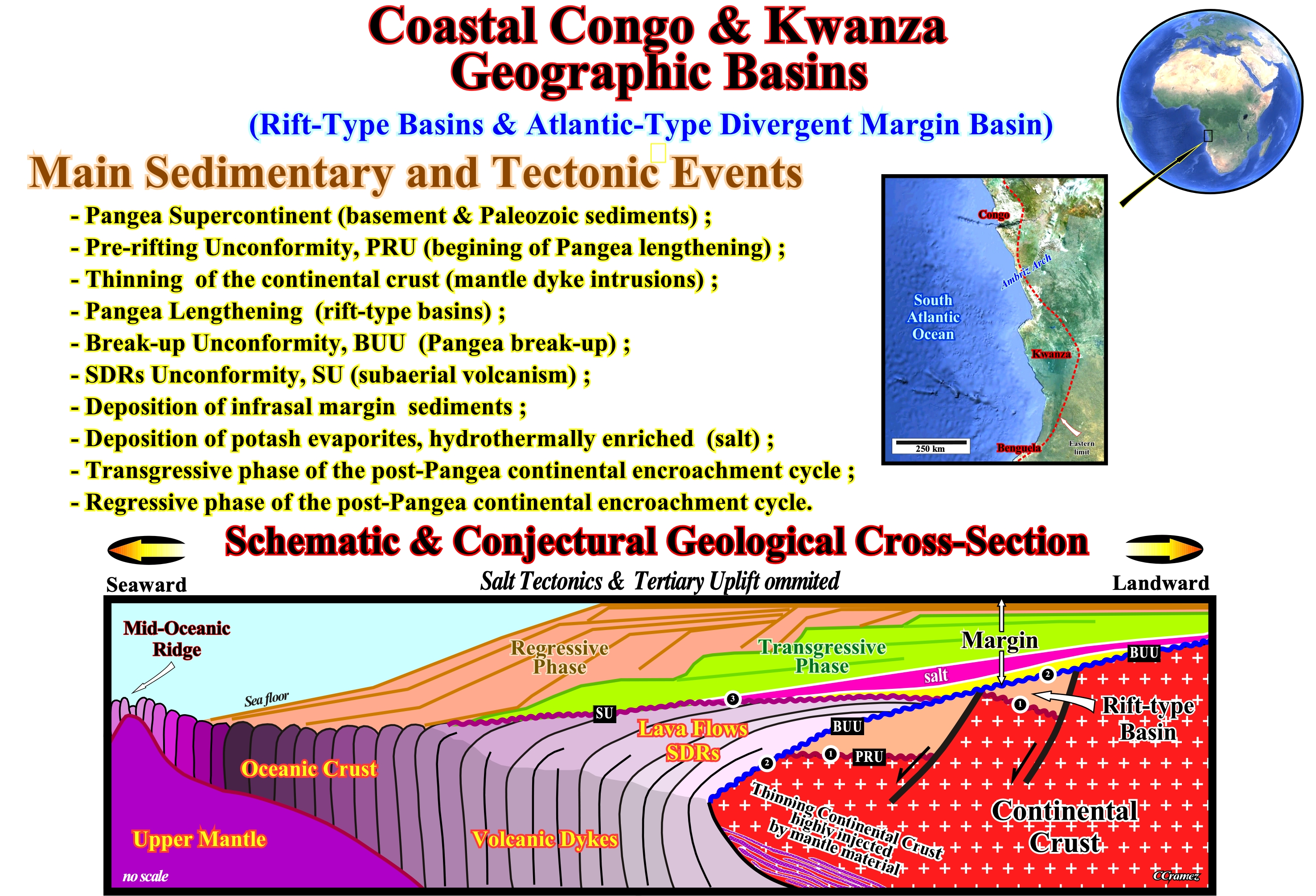
Figure 010- As illustrated, Congo and Kwanza geographic basins are located in the western margin of Africa, between Namibia (southward) and Gabon (northward). Both geographic basins have an onshore and offshore sector. Taking into account the classification of sedimentary basins proposed by A. Bally and S. Snelson (1980), these basins correspond to a temporal and spatial stacking of different types of sedimentary basins. They were formed before and after the break-up of southern Pangea supercontinent (Gondwana) formed by agglutination of the continents derived by the break-up of the Precambrian supercontinent (Rodhinia or Proto-Pangea). In the schematic and conjectural geological cross-section, illustrated above, it is easy to recognize the main tectonic and sedimentary events associated with the break-up of the Gondwana lithosphere : (i) Before the break-up, the Gondwana lithosphere underwent an important lengthening (rifting) during which rift-type basins developed (half-grabens filled by non-marine sediments, sometimes rich in organic matter ; the parallel internal configuration of the type-rift basins - extension rate higher deposition rate - suggests the deposition of organic-rich sediments, i.e., potential source-rocks) ; (ii) The break-up of the lithosphere was the result important injections of mantelic material in a thinning continental crust ; (iii) Immediately after the break-up, the eastern and western margins of South America and Africa lithospheric plates were accreted by sub-aerial lave flows ejected from the expansion centers (volcanoes) that pinchout continentward (craton) ; (iv) With time, the loading of the successive lava flows put under water the sub-aerial the centers of expansion, ending the flowage of the volcanic material (it froze under water) initiating the creation of pillow lava, i.e., the creation of the oceanic crust ; (v) At the same time, the absolute (eustatic) in sea level rise concomitant with formation of oceanic crust (oceanization and dispersion of lithospheric plates) created space available for sediments (accommodation) over the margins, whose stratigraphy will be discussed later.
c.2) Opening Geological Model
As illustrated in the figure 011, during the rifting phase (between roughly 135 and 115 Ma), the break-up of the Pangea lithosphere took place, probably, in association with underlying mantle plumes. Each plume of the asthenosphere corresponds, roughly, to a thermal anomaly that rising lengthened the overlying lithosphere creating a large dome. Such lengthening of the continental crust created asymmetric rift-type basins located, more or less, along rupture zone (future ocean). As the lithosphere thinned due to lengthening and heating (cause or effect), the igneous activity became, increasingly, intense, especially near the future break-up line of the lithosphere. A large number of geoscientists think since the continental crust reaches a stretching ratio of β = ± 2, mantelic injections became quite abundant either as dikes or laccoliths in the extended continental crust. Probably, before reaching the theoretical limit (β = 4.5), the continental crust (stretched and highly injected by volcanic material) broke-up, at 135-130 Ma. The break-up of the lithosphere was made, mainly, due to the predominance of injected volcanic material (not as a result of the thinning of the continental crust) allowing the spreading of the individual lithospheric plates due to a major volcanic lateral accretion (flows of basaltic lava during the Neocomian).
The stretching of the Pangea lithosphere ended with the break-up of the continental crust. The age of the break-up varies from south to north. All rift-type basins*, that allowed the lengthening, are bounded by the pre-rifting (PRU) and the break-up (BUU) unconformities.
* In South Angola and Namibia offshores, the lower seismic intervals dipping and thickening seaward were, conventionally, considered as rift-type basin sediments with hydrocarbon potential (source-rocks). Such hypothesis was falsified by an exhaustive geological interpretation of the regional lines made by Total's geoscientists and by drilling results. The dipping and thickening seaward intervals postdate the break-up unconformity. They belong the continental margin and not to rift-type basins. The conjecture that such intervals simulate lava flows (as in Vøring plateau, North Sea), i.e., without any hydrocarbon potential was not yet falsified.
The lava flows (volcanic material freezes under water) postdate the break-up unconformity. They flowed continentward from sub-aerial expansion centers. Lava flows can cover the most distal rift-type basins (± 10-15 km from the break-up zone). They thin, also, continentward and piled-on each other. The stacking geometry when, more or less, sub-horizontal mask the magnetic reversal induced by the different flows (underlying volcanic dikes are linked more to west). For this reason, the sub-aerial volcanic crust (SDRs) is considered to be magnetically neutral. The continentward flow of the volcanic material is discontinuous (in time and space). Discontinuities (not unconformities) between different episodes of lava flows are possible, as well as, fine sedimentary intercalation (without petroleum potential).
With time, due to the loading of the lava flows, the sub-aerial expansion centers became submarines with formation of pillow lava (volcanic material froze, quickly, under water). Following the immersion of the centers expansion, they migrated, laterally, due to the injection of new volcanic dykes (oceanic expansion), creating the characteristic vertical geometry of the oceanic crust. This geometry is much more favorable than the sub-horizontal geometry of sub-aerial volcanic crust (SDRs) to recognize the magnetic anomalies associated with the sea floor spreading.
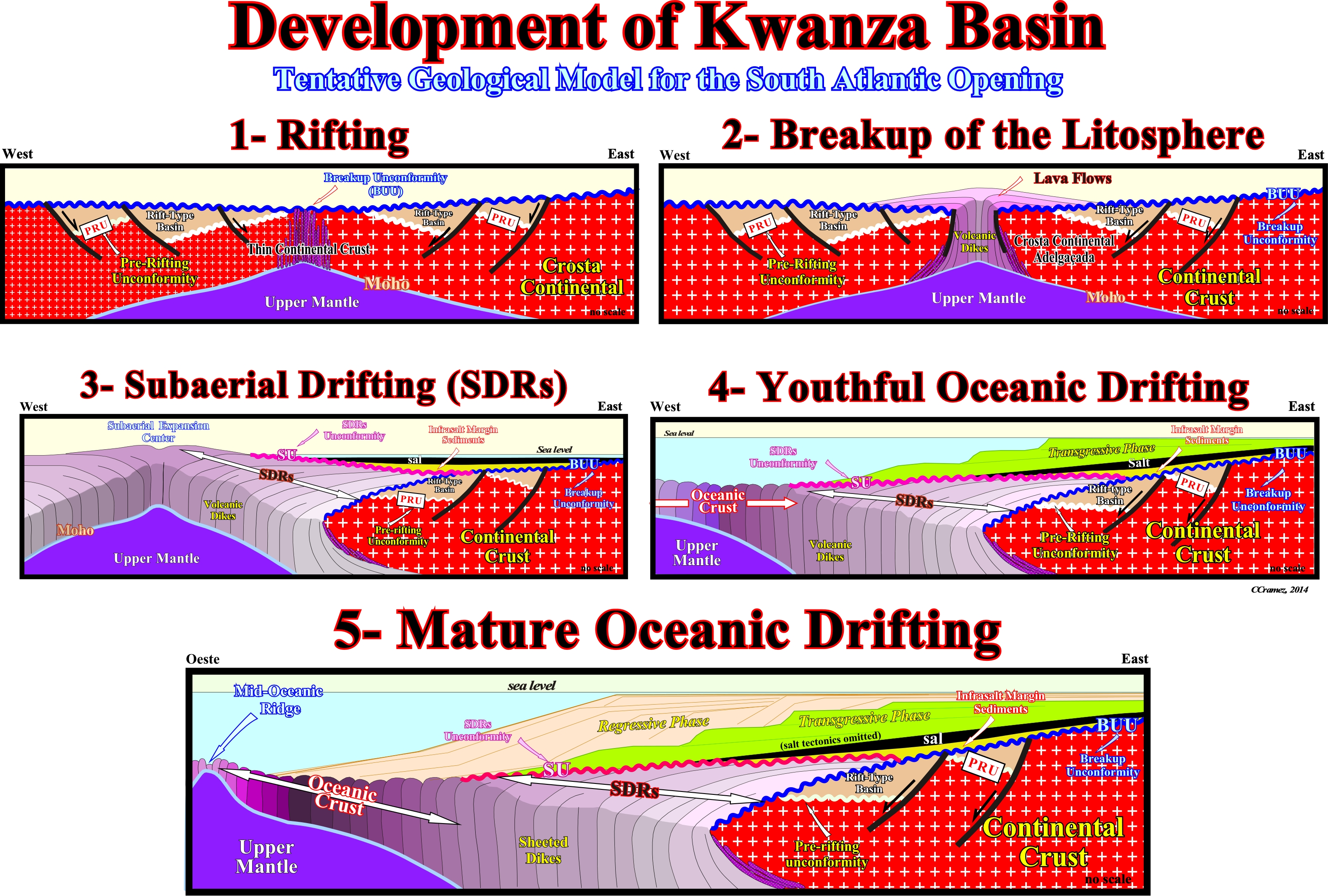
Figure 011- The main tectonic-stratigraphic phases of the South Atlantic opening and formation of Kwanza geographic basin are: (1) Rifting: a) Lengthening and thinning of the Gondwana continental crust by normal faulting ; b) Injection of mantle material (dikes) ; c) Development of rift-type basins above the pre-rifting unconformity (PRU). (2) Break-up of the Lithosphere (predominance of injected volcanic material over the continental crust): a) Break-up unconformity (BUU) ; b) Lava flows ; c) Onset of subaerial volcanic expansion. (3) Sub-aerial Drifting (SDRs): a) Sub-aerial expansion centers ; b) Sub-aerial volcanism ; c) Seaward thickening and dipping of the reflectors (lava flows) ; d) SDRs unconformity (SU) ; e) Proto-ocean (epicontinental seas or lakes) ; f) Deposition of basal sediments of the divergent margin (sandstones, shales, limestones and and evaporites). (4) Youthful Oceanic Drifting: a) Submersion of the sub-aerial expansion centers ; b) Oceanic crust ; c) Deposition of the transgressive phase of the Post-Pangea continental encroachment cycle ; d) Progressive sinking of transgressive sediments (retrogradational geometry) and formation of continental shelves. (5) Mature Oceanic Drifting: a) Continuation of the oceanization (oceanic crust) ; b) Seaward shoreline displacements and deposition of the regressive phase (progradational geometry) of post-Pangea continental encroachment cycle above the transgressive phase ; c) Progressive disappearance (long-term) of most continental shelves.
The oceanic expansion (sea floor spreading) give rise to the drifting of the lithospheric plates (± 115-85 Ma), which induced the transgressive phase of the post-Pangea continental encroachment cycle. The deposition of Aptian evaporites and/or sandstone marked the onset of Cretaceous sedimentary transgression, which continued until the end of the Cenomanian-Turonian. The Cretaceous sedimentary transgression was induced by the absolute (eustatic) sea level rise created by an increasing volume of ocean ridges and rate of oceanic expansion. The amount of water, in all its forms, is supposed to be constant since the Earth's birth (± 4.5 Ga). Following the composite marine ingression (increasingly important marine ingressions), a sedimentary wedge was, progressively, built by carbonate and siliciclastic units, globally, thickening continentward, i.e., with a retrogradational geometry. Such a geometry, is the result of increasing smaller sedimentary regressions, deposited during the periods of stability of the relative sea level (absolute sea level + tectonics).
Since the volume of ocean basins started to increase, due to the collapse of ocean rides and subduction of oceanic crust along the Benioff subduction zones, for the same amount of water (in all forms), the absolute sea level started to fall initiating the regressive phase of the post-Pangea continental encroachment cycle. During this phase (± 60-0 Ma), the falling of the absolute sea level, during the Tertiary, was reinforced by epeirogenic uplifts of continental crust. Both South Atlantic margin increased due to progradation of a regressive wedge (sedimentary prism). On seismic lines, the regressive phase is separated from the underlying transgressive phase by a major downlap surface. Continental facies (lithologies) shift seaward. The successive depositional coastal breaks (± coastline) were, progressively, displaced seaward until total fossilization of the shelf (no shelf). The sediments of the regressive phase thickened seaward and then tapering in deep water. Epeirogenic uplifts of several kilometers occurred to the stresses created within the continents by the underlying igneous activity.
Locally, epeirogenic uplifts reinforced the continental margins and major unconformities during the Middle Tertiary. The uplifts are, easily, recognized on seismic lines, particularly, in onshore, where they are more significant (2-3 kilometers). The uplifts explain why the organic matter of the potential source-rocks reached maturation, since, in many areas, presently, they are very little buried. We must be aware of the difference between absolute sea level and relative sea level (absolute plus subsidence or uplift of the sea floor). The absolute sea level fall occurring during the Tertiary, induced the regressive phase of the post-Pangea continental encroachment stratigraphic cycle. At the hierarchical level of stratigraphic sequence-cycle, a relative sea level fall induces an unconformity, i.e., an erosional surface. Similarly, a composite relative sea level rise in acceleration (increasingly important marine ingressions) induces a sedimentary transgression and a composite relative sea level rise in deceleration (increasingly smaller marine ingressions) induces a sedimentary regression.
In the hypothesis proposed by Total's geoscientists for the opening of the South Atlantic, the sub-aerial lava flows (SDRs, i.e., the reflectors dipping and thickening seaward) and evaporites postdate the breakup of the Pangea lithosphere. The rift-type basins created during the lengthening of the lithosphere, before the breakup, are bounded by the breakup unconformity and fossilized (covered) either by : (i) Infra-salt margin sediments (evaporites or basal sandstones) ; (ii) Supra-salt margin sediments or (ii) SDRs (in the more distal rift-type, i.e., in the basins near break-up zone).
Summing up:
(I) The South Atlantic opening model proposed by Total's geoscientists, in which the salt interval is deposited after the break-up of the Gondwana lithosphere during the drifting of the African and South America plates follow Guiraud and Maurin (1992) and Karner et al., (1999) who postulated that rifting ended before salt deposition.
(II) The conjugate twin salt basins (Gabon-Angola and Brazil) have always been separated and independent.
(III) The Aptian salt interval was deposited after the break-up unconformity (3D plate tectonic reconstructions are highly significant).
(IV) At the distal edge of the salt basins (in the direction of break-up zone), the salt onlap against the oceanic crust or against the sub-aerial volcanic crust (proto-ocean). When the salt is not deformed, on the seismic lines, the allochthonous salt, onlap on the oceanic crust in the Lower Congo Basin (Lehner and De Ruiter, 1977), South Gabon Basin (Meyers et al., 1996a) and North Gabon and Douala Basin (Meyers et al., 1996b).
(V) In other parts of the African margin (Lower Congo Basin, Kwanza and Benguela), the allochthonous salt is, tectonically, thickened (reverse faults and thrust faults). The salt is allochthonous, along the main distal border, and forms the Angolan Escarpment, which masks the original salt geometry and the evidence of SDRs, which were identified on both margins (African and South America) under the base of the salt intervals or its stratigraphic equivalents.
(VI) The conjecture advanced by Total's geoscientists is corroborated by geochemistry and mineralogy of evaporites, which suggest an association of Aptian evaporites with the basaltic lava lava flows (Hardi, 1983, 1990, 1996) :
a) The evaporites rich in potassium are diagnostics of salt water.
b) They form two groups :
1) A rare group, rich in MgSO4, formed by evaporation of seawater from rivers (mineral sulfate, polyhalite, kainite and kieserite, are diagnostic) ;
2- The second group, the most common, is rich in KCl and CaCl2 is poor in MgSO4 (this group can not be formed just by evaporation of sea water from rivers (the minerals chloride, sylvite, carnallite, and tachyhydrite and bischofite are diagnostic).c) The brines of CaCl2 that focus to form minerals KCl have been derived from brines enriched by the interaction CaCl2 hydrothermal water-rock. The most suitable rock pair such hydrothermal interaction is basalt altered by spilitization. The albitization releases Ca in the brine, and the chloritic Mg absorbs the brine. As the brine precipitates hydrothermally, abundant Ca combines with any SO4 this to precipitate gypsum on the surface. The brine lakes remains enriched Ca.
c) The brines of CaCl2 that concentrated to form minerals KCl are been derived from brines enriched in CaCl2 by hydrothermal water-rock the interaction. The most suitable rock for such hydrothermal interaction is basalt altered by spilitisation. The albitization releases Ca in the brine, and the chloritization absorbs the Mg of the brine. As the brine precipitates hydrothermally, abundant Ca combines with any SO4 present to precipitate gypsum on the surface. The brine in lakes remains enriched in Ca.
d) Other rocks (host) beyond the basalt are possible. The brine can interact with the plagioclase of the arkoses or with Ca smectites of red sand. Limestones can also be a prolific source of Ca, but they are rare these under the Aptian salt in South Atlantic.
e) The presence of tachyhydrite and similar chlorides does not prove that the substrate of evaporites is basalt. However, the thickness, high temperatures and the abundance of plagioclase in basaltic lava flows means that these rocks are most appropriate for providing Ca to CaCl2. All potash Aptian evaporites known in the South Atlantic, were formed from CaCl2 brines, enriched by hydrothermal alteration.