

Geological Map of Kwanza Geographic Basin
The geological map of the Kwanza geographic basin illustrated in figure 012 corresponds to the mapping of the onshore of the Kwanza Geographic Basin. It was made by the geoscientists of Total CAP (Compagnie Africaine des Pétroles, a subsidiary of Total SA working in Angola) between 1968 and 1972, using aerial photographs and field observations. At that time, the local topographic maps were, practically, non-existent or inappropriate to support a geological cartography. Obviously, in relation to modern topographical maps of the area, it is more than possible than some contacts between the geological formations as well as the location of certain faults are in a wrong position. This applies, also, too the location of exploration wells, especially, the old ones (drilled between 1906 and 1970), which location was made in reference to monuments or house farms (e.g., the well A is located 150 meters SW of the Muxima Church). In other words, despite the old falsification tests to which this map was submitted, taking into account the new topographic data and the enormous progress of geological knowledge, volens nolens, this geological map must be, largely, redone. A critical discussion, even of the best geological maps, reveals, always, errors.
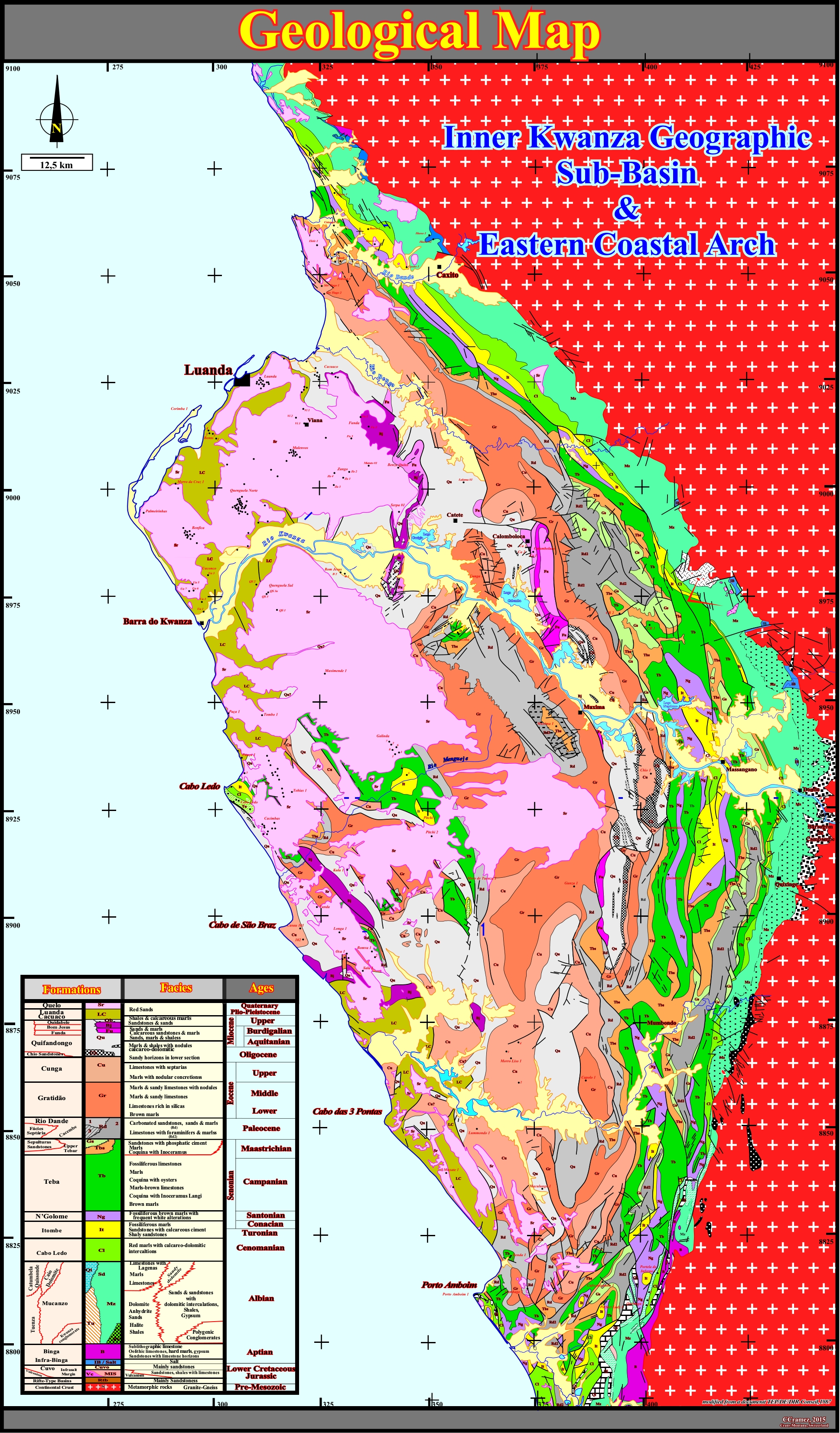
Figure 012- The stratigraphic column used for the preparation of this geological map was build-up from publications and the results of Petrangol exploration wells. It was tested by two significant geological cross-sections : (i) The geologic cross-section between St. Tiago Beach* and Barra do Dande, through the cliffs the coastline and (ii) The geological cross-section between Quifangondo and the Tentativa Farm, along the railway track that should be built between Luanda and the Democratic Republic of Congo via Uige. The new outcrops trenches created by the recent roads and seismic paths (e.g., SKB seismic grid shot, recently by Sonangol), have to be taken into account, which will bring, of course, a certain number of corrections. A glance at this geological map suggests a lot of bell-shaped structures. By the same token, the shoreline geometry suggests the tectonic of substratum played an important control in the evolution of this onshore, as we will see later. The tectonic structures are most noticeable in simplified geological maps (figure 013). They will be described and analyzed next.
* I assume that the participants at this workshop know the regional geography of the Kwanza geographic basin, particularly, the localities, spaces and territories that lead to a definition of regional groups in terms of structures, systems and scales.
On the control map supporting the geological map, the shoreline shows a lot of dextral shifts. They are, particularly, visible in the areas of Porto Amboim, Cabo das Três Pontas, Cabo de São, Carimba Bay, Barra do Dande, etc. Similarly, the strike of the Mussulo and Luanda sandbars, as well as the Luanda and Carimba bays, plays in the same sense. These shifts and the SW-NE direction of the shoreline seem to highlight the reactivation of old Precambrian or Paleozoic fracture zones of the Gondwana small supercontinent (southern Pangea continent), which and affect the entire Kwanza geographic basin.
a) Simplified Geological Map & Structural Sketch
The simplified geological map, illustrated below (figure 013), is a chronostratigraphic map, in which just the more significant faults were taken into account. Eleven (11) time intervals were considered. From the bottom to top they are:
(i) Pre-Mesozoic (white crosses on a red background) corresponds to the substratum ;
(ii) Jurassic/L. Cretaceous (light yellow) comprises rift-type basins (do not outcrop) and the infra-salt margin sediments ;
(iii) Aptian (light blue), includes the Binga and Infra-Binga formations and evaporites (do not outcrop) ;
(iv) Albian (dark blue), includes the Mucanzo formation and lateral equivalents (Tuenza, Catumbela/Quissonde, etc) ;
(v) Cenomanian/Santonian (pink) comprises the Cabo Ledo, Itombe and Bolometer formations ;
(vi) Campanian/Maastrichian (green) corresponds to the Teba Formation and lateral equivalent (Sepulturas sands) ;
(vii) Paleocene (beige) corresponds to the Rio Dande formation ;
(viii) Eocene (brown) corresponds to the Gratidão and Cunga formations ;
(ix) Oligocene/Miocene (yellow) corresponds to the Quifangiondo formation and associated lateral facies ;
(x) Plio-Pleistocene (ocher) includes the Cacuaco and Luanda formations and
(xi) Quaternary (white) corresponds to the Quelo formation.When the map was made, the large majoriy of the discernible structure were considered anticlines and synclines, in spite of the fact than certain Total's geoscientists found very strange the absence of reverse faults in association with such structures (exception for Cabo Ledo structure). In fact, at that time, the theory of the anticline was predominant in petroleum exploration and our geological approach was too much inductive. The geoscientists who put together a geological map without any pre-idea (I was one of them), spent too much time on the field without having any idea of the problem to solve. They made dozens of stratigraphic section, taking hundreds of rocks samples (without knowing what they should look for) as a collector accumulate stamps or butterflies. Later, I learned geological observations are, entirely, dominated by the theories adopted by the geoscientist and scientific field geology, as any geological work, does not starts with data, but with the choice of a significant geological problem, that is to say, with a question reflecting the problematic situation and.
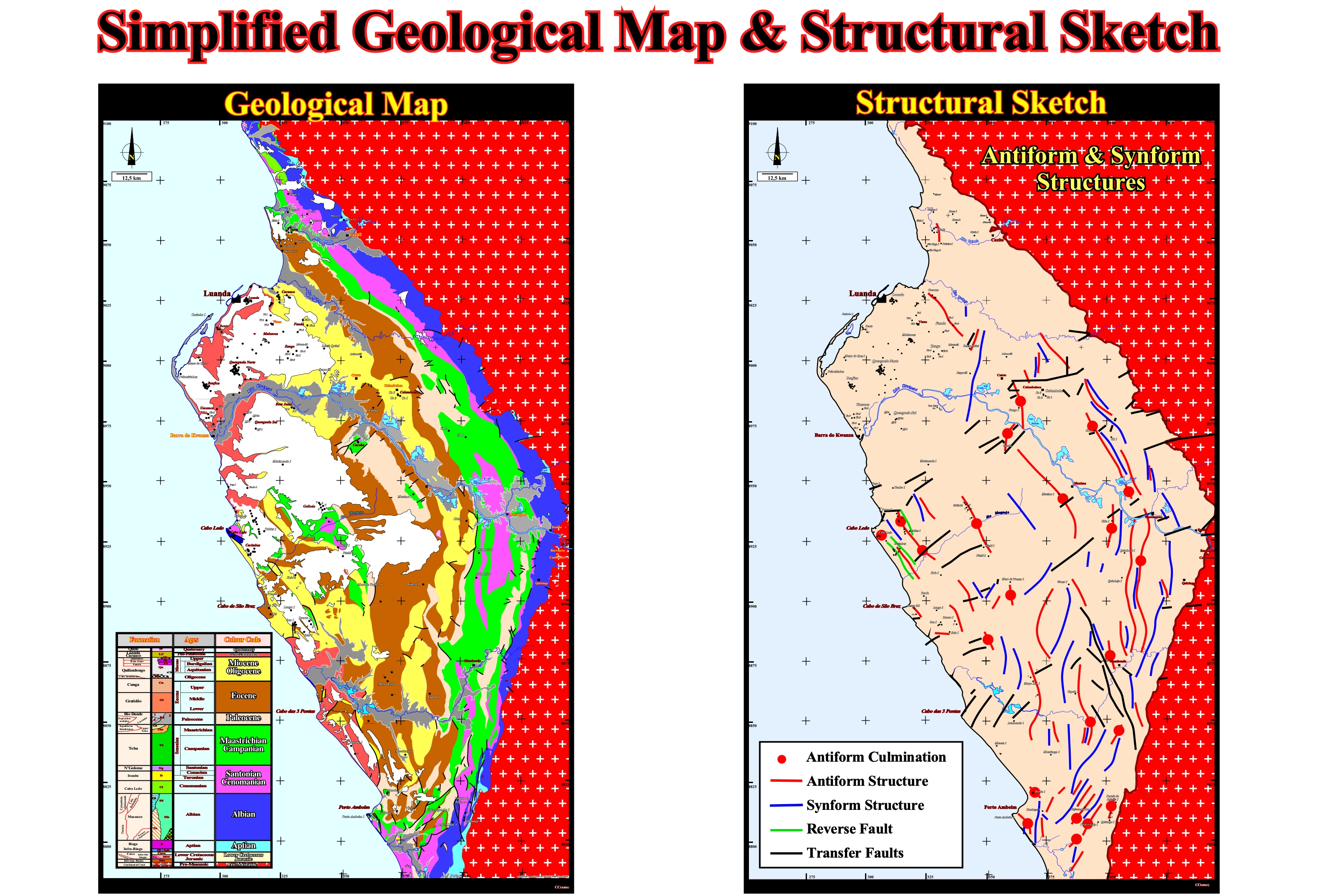
Figure 013- On the simplified geological map, the mapped intervals are chronostratigraphic packages and not the geological or the lithostratigraphic formations. The Quaternary sediments are colored in white. The Albian sediments are colored in dark blue. In distal and central part of the basin, the chronostratigraphic packets are aligned, more or less, parallel to the Eastern limit of the basin. This suggests the sediments are, globally, lengthened. In SW sector of the geographic basin, the direction of the sedimentary package is, more or less, NW-SE, i.e., roughly parallel to the shoreline. In the northern part (particularly in the area of Luanda and Barra do Dande, where the coastline is oriented NE-SW), the strike of the beds and chronostratigraphic intervals is, clearly, oblique to the shoreline. Northward of Dande River, the direction of the beds and contacts, between the different packages, is roughly parallel to the shoreline, which is, more or less, parallel to the eastern limit of the basin. The Aptian sediments (evaporitic Loeme formation) do not outcrop. In Pitchi and Tobias areas, the salt interval is represented by diapiric structures that almost reach the surface. The infra-salt sediments outcrop just in a small quarry in the southern part of the basin, near the Boca do Inferno wells. The coastal arch is not too evident, except in Cabo Ledo area, where Cretaceous sediments (Santonian / Cenomanian and Albian) outcrop in association with reverse faults, suggesting a local compressional tectonic regime. However, in the 70s, all bell-shaped structures were considered with anticlines and the associated traps as structural. Practically, all bell-shaped structures were screened by exploration wells located in the apex of structures. Many of these structures end against transfer faults, striking SW-NE, which express, in surface, the reactivation of Precambrian fracture zones. Today, we know that anticlines and synclines are shortening structures. They are associated with compressive tectonic regimes (σ1 horizontal) characterized by triaxial and oblong (flattered) ellipsoid of effective stresses (sum of geostatic pressure, pore pressure and tectonic vector). There are no normal faults coeval with a sedimentary shortening (in the same place and at the same time, there is shortening or lengthening, but not both). Antiforms and synforms are extensional structure, i.e the sediments are lengthened. They are induced by an extensive tectonic regimes (σ1 vertical), characterized by a triaxial ellipsoid stretched vertically. These structures are always associated with normal faults, but the throw of the faults (throw is vertical component of the separation and heave is the horizontal component) may be lower than the resolution of seismic lines (less than 20-40 meters). do not forget there is just one way to lengthen the sediments, i.e., by normal faulting.
Since the Petrangol's exploration wells recognized a significant salt layer on the stratigraphic column, the lateral thickness changes of certain geological formations and the large Cenozoic depocenter discernible on the geological maps were, tentatively, explained by salt movements with or without extension (diapirism, salt flowage, raft tectonics). The structural sketch illustrate above (Figure 013), takes already into account certain tectonic concepts that were, totally, unknown in the 60's, but fundamental for the petroleum exploration, like:
(i) An anticline is a shortened structure induce by a local or regional compressional tectonic regime (σ1 horizontal), while an antiform is a lengthened structure induced by induced by a extensional tectonic regime (σ1 vertical).
(ii) Faults (parallel to σ2) associated with an anticline are reverse faults, while faults (parallel to σ2) associated with an antiform are normal faults.
(iii) Taking into account the limits of inter-granular and inter-atomic plasticity, cemented sediments can be shortened by folding or by folding plus faulting (when the shortening by folding is not big enough to accommodate the sediments). However, they can just be lengthened by normal faulting (there is not another way to lengthen them). Said in another way, shortened sedimentary structures can exist without reverse faults, while lengthened sedimentary structures must have normal faults.
(iv) An anticline is a potential structural trap, while a antiform not. In an antiform there is morphological traps by juxtaposition, due to the lengthening of the reservoir-rock by normal faulting.
(v) In a structural trap, all sedimentary intervals (reservoir and sealing-rocks) have the same bell-shaped geometry and the beds dip away, in all directions, from the apex of the structure. An exploration well located at the top of the anticline will pass through all beds in ideal condition for trapping hydrocarbon (a reservoir-rock covered by a sealing-rock is required).
(vi) In a morphological trap by juxtaposition, the relative movement of the normal faulted-blocks can put a footwall reservoir-rock in juxtaposition with a hangingwall sealing-rock. However, such a juxtaposition (lateral seal) is not sufficient to trap the hydrocarbons, a vertical seal is also required. Furthermore, the geometries of the reservoir-rock and lateral sealing-rock are quite different.
(vii) To test the potential of a structural trap (all other petroleum parameters being equal), geoscientist need just a structural map of reservoir-rock to locate an exploration well in the apex of the structure. On the contrary, to test a morphological trap by juxtaposition (reservoir-rock dipping in opposite direction of the fault plane), geoscientists to locate an exploration well, need several maps :
a) Structural map of the footwall reservoir-rock (reservoir-rock is conform to vertical sealing-rock) ;
b) Structural map of the hangingwall lateral sealing-rock ;
c) Structural map of the fault allowing the juxtaposition ;
d) Determination of real throw of the fault, i.e., the vectorial sum of the horizontal and vertical throw ;(v) Playing with these maps, geoscientists can see if there is juxtaposition or not, between the reservoir-rock and the lateral sealing-rock. In the case of juxtaposition, taking into account the structural component of the reservoir-rock, it is, easy, to locate the exploration well more chances of find a profitable hydrocarbon accumulation.
Summarizing: In the Kwanza geographic basin, the petroleum exploration was made: A) Keeping in mind, the anticline theory (between 1968 and 1972, all mapped structures, in the field or the seismic lines, were, erroneously, taken as anticlines, i.e., with a four way dip closure ; B) With mistake interpretations of the potential trapping mechanism and with mis-correction of the non-migrated seismic data (the majority of the well drilled do not tested any closed potential reservoir-rock) ; C) Targeting supra-salt potential prospects (with exception deep Calamboloca well) ; D) With seismic data unappropriated to map correctly any infra-salt horizons (which is not the case with the Sonangol new seismic data).
b) Present-Day Geological Knowlege of the Area
More than fifty years ago, when the maps geological map was done, the geological and petroleum knowledge of the area it was not the same than today. It has increased a lot. The same is true for the for the epistemology in Natural Science, particularly, in geology and petroleum exploration. The Baconian inductive philosophy, very fashionable in the past, is, progressively, being replaced (in certain oil companies) by a rational philosophy, in which the growing of geological knowledge is the result of critical discussions and try and errors. On this subjects, following K. Popper (1996), we can say:
1) There is no pure geological observation, i.e., a geological observation has, always, a theoretical component ;
2) Geological observations and, particularly, experimental geological observations (e.g., geological interpretation of the seismic lines, for instance) are interpretation of events in the light of one geological theory or another ;
3) A geological theory precedes, always, a geological observation ;
4) Geological knowledge is hypothetical and conjectural ;
5) The increasing in geological knowledge consists of learning from our mistakes, i.e., the scientific geological method consists of systematic learning through our mistakes ;
6) In a critical geological discussion, among the most used arguments are the drilling well results and tentative geological interpretation of the seismic lines (experimental tests) ;
7) Drilling locations, for instance, are, constantly, created by a theory, by theoretical guesses that geoscientists are, often, not aware of, by hypotheses regarding possible sources of drilling errors and by hopes or conjectures about what will be a successful drilling ;
8) The fundamental role played in petroleum exploration by theories, hypotheses or conjectures makes it important to distinguish between geological theories that can be tested or falsified and not tested or not falsifiable ;
9) No geological theory can tell us anything about the empirical world unless in principle it is capable of clashing with the empirical world, i.e., unless it is refutable ;
10) In Geology and particularly in Petroleum Geology, authoritarianism is linked to the idea of establishing, i.e., of proving or verifying geological theories or conjectures.
On the other hand, an young geoscientists has much more geological knowledge than in the past. The Plate Tectonics Theory, which so far has resisted to all critical tests, them a fairly satisfactory global geological context. The Sequential Stratigraphy, the Seismostratigraphy (due to the huge progresses in seismic acquisition and processing), the computer modelling, etc., are the background of all geological observations (direct or experimental). There are no more "tabula rasa" geoscientists, they have their minds full of geological knowledge. When they have determine what is the real geological or petroleum problem, they try to solve it, proposing hypotheses and testing them by a critical discussion, which, generally, creates a new problem, and so on. Karl Popper summarized this rational scientific process by three words: Problem, Hypothesis, Test.
Actually, the large majority of the geoscientists, working in South Atlantic offshores, to solve their geological and petroleum problems know, already, a priori, following geological conjectures:
(i) South Atlantic margins, for the most of them, are volcanic ;
(ii) Rift-type basins predate the break-up of the Gondwana lithosphere, i.e., they are contemporaneous of the lengthening of the lithosphere ;
(iii) Potential lacustrine source-rocks can be deposited in, relative, large rift-type basins, when the rate of extension is not compensated by the rate of terrigeneous influx (creation of a water-depth);
(iv) The break-up of the lithosphere is accompanied by the emplacement of lava flows (moving outpouring of lava created during a non-explosive effusive eruption) ;
(v) Lava flows are paramount in border and proximal area (continentward) of the break-up zone ;
(vi) Lava flows thin away from the sub-aerial spreading centers, i.e., they thin continentward ;
(vii) Lava deltas with continentward slopes are, likely, wherever lava enter a standing water body (lake or epicontinental sea), since lava cannot flow under water.
(viii) As spreading centers subside due to the loading of successive lava flows, they dip, more and more, seaward ;
(ix) Since the spreading centers become submerged, the volcanic material arriving to the bottom of the sea solidify forming oceanic crust (pillow-lava) ;
(x) Divergent margins, which postdate the break-up of the lithosphere, are induced by the post-Pangea 1st order eustatic cycle responsible for the deposition of the stratigraphic continental encroachment cycle, in which two stratigraphic phases are deposited (transgressive and regressive phases) ;
(xi) In the stratigraphic transgressive phase, landward of the lava flows, above the rift-type basins or the Gondwana lithosphere, lacustrine depocenter with potential source-rocks, are deposited, before being covered by relatively thin fluvial to shallow-water marine sandstones ;
(xii) A thick salt layer is deposited from an enriched potash brine (interaction between the lava flows and the sea water) above the fluvial to shallow-water marine sandstones ;
(xiii) The stratigraphic transgressive phase ends with the deposition of a salt overburden with a retrogradational geometry ;
(xiv) Above the stratigraphic transgressive phase, a regressive phase is deposited with a progradational geometry ;
(xv) Potential marine source-rocks are deposited, mainly, in association with the major downlap surface, which separated the two stratigraphic phases.