
Seismic Survey & Geological Maps
On this page we will see, mainly, the location map of the old seismic lines (prior 1972), shot by Petrangol and Total CAP, as well as, the old lines re-processed by Sonangol with seismic examples. Likewise, we will show the new seismic grid SKB (2012) shot by Sonangol on the morphological map (GoogleEarth), as well as, on the geological map, fracture zones map and geological provinces. The maps allow geoscientists in charge of the tentative geological interpretation, to guess what they must look for on seismic line and then test their tentative interpretation, i.e., eliminate their errors, which generate new geological and petroleum problems.
a) Old Seismic Lines (pre-1972)
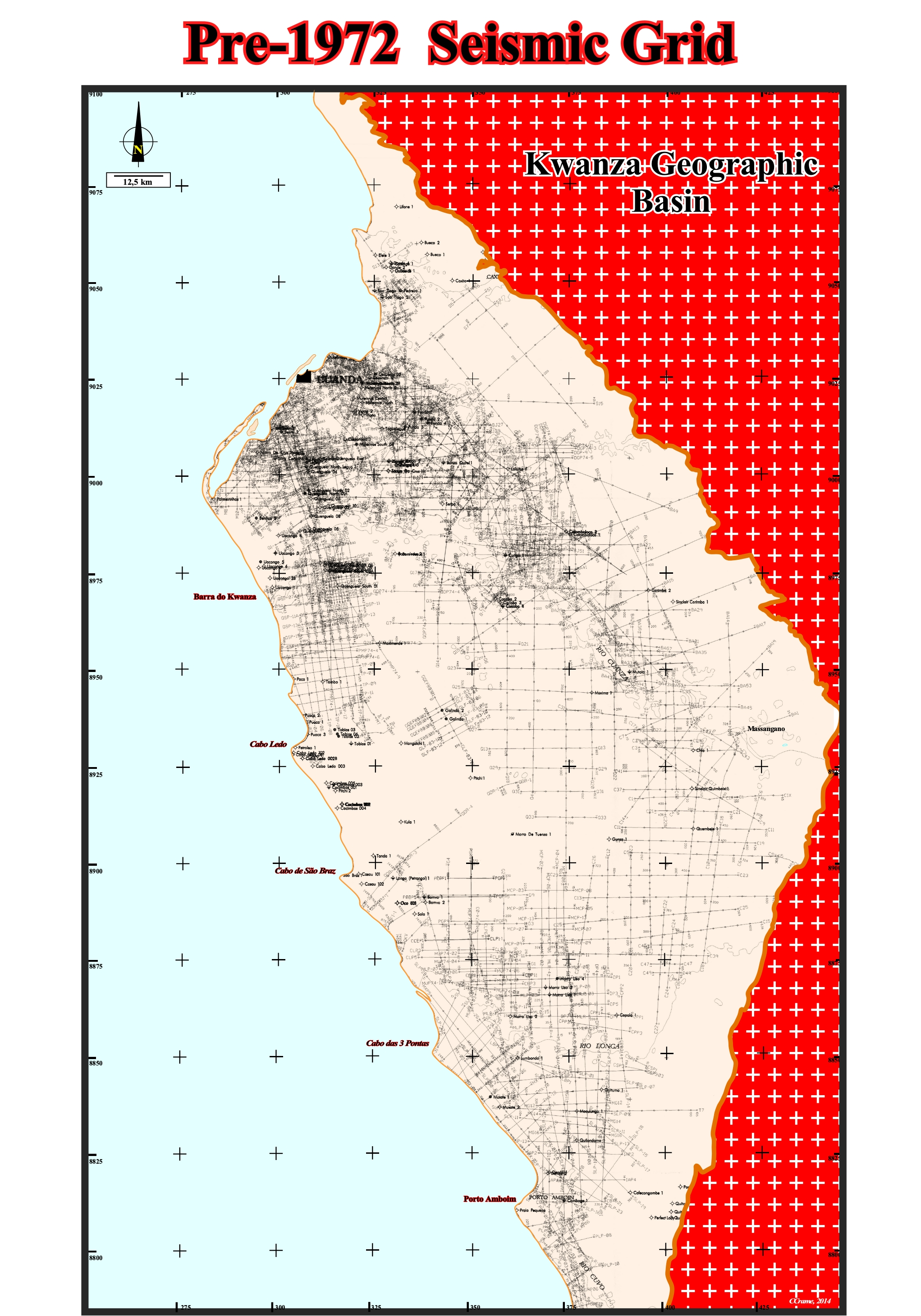
Figure 045- In this map are located all seismic lines (around 10, 300 kilometers) shot by Petrangol and Total CAP. Petrangol began the onshore Kwanza exploration after the second world war. Petrangol shot about 6,000 km of seismic lines on the basis of which, approximately, 150 wells (exploration and development) were drilled. Total CAP starts to explore this onshore in 1968 shooting about 4,300 km of seismic lines that allowed the drilling of 15 exploration wells until 1975. All of these seismic lines, which we call old lines are 2D classic lines, prior to advent of migration. In other words, longitudinal seismic coherence (along the profiles) is good, but the lateral coherence (perpendicular to the lines) is not so good, sometimes in a ratio of 1 to 100. In addition, the profile shot in two directions, more or less perpendicular, do not take into account that one inclination component (dip) of the reflectors, in general, different from a direction to another. This seismic is just exploitable, correctly, in the case of low inclinations or uniformly cylindrical structures aligned along the profiles. The migration (process that is based on the wave equation that (i) correct the distortions of the reflection records, (ii) place in the real spatial positions of the reflections, before or after stacking and (iii) a reduce diffraction figures collapsing the energy of diffractions to their point spread or diffusion) was not available. In other words, the old seismic lines are of poor quality and difficult to interpret in geological terms as illustrated in the figure below.
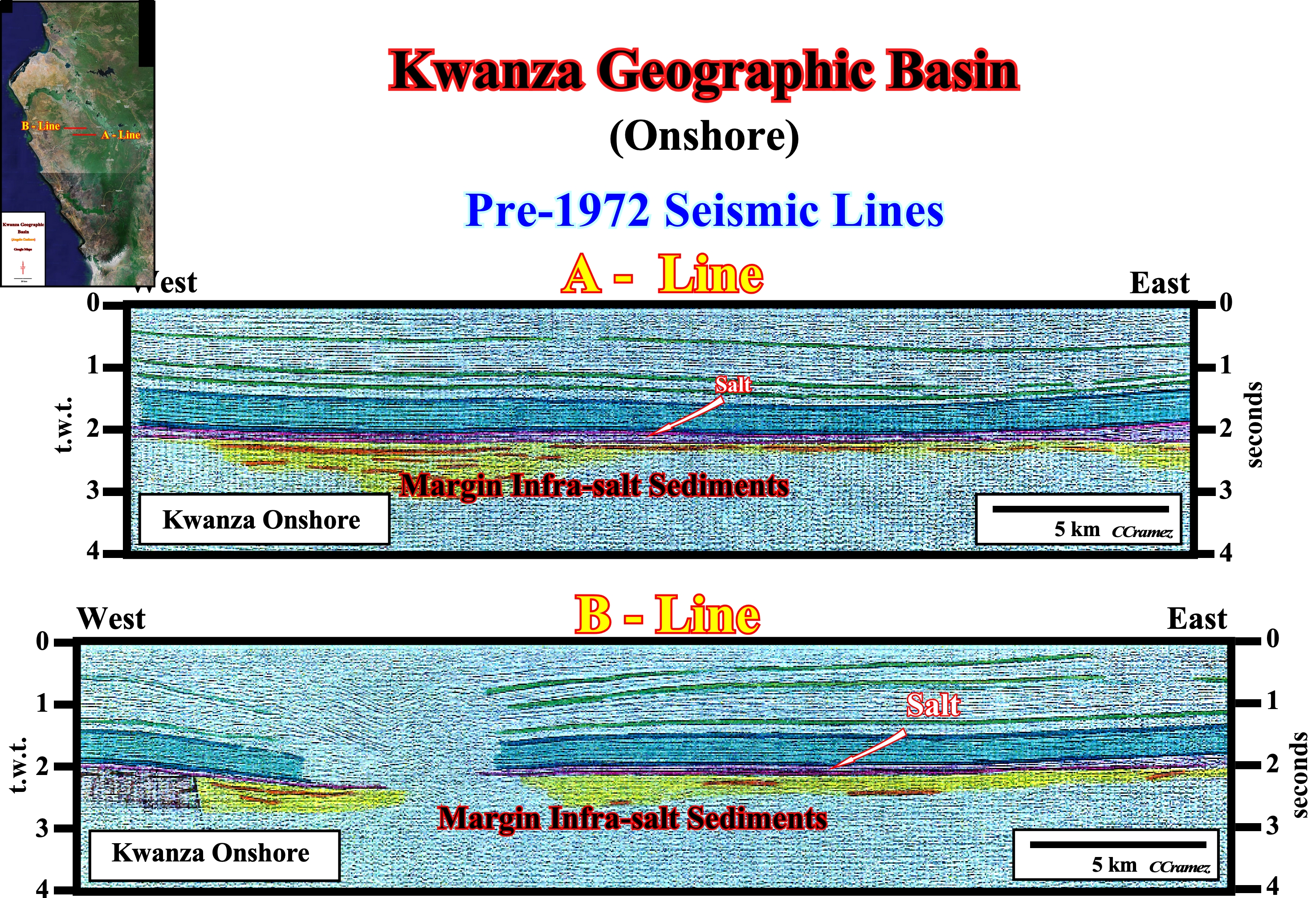
Figure 046- This figure illustrates two tentative geological interpretations of two parallel old seismic lines of Kwanza onshore, made in early 70's. Despite the slight dip of the reflectors (favorable condition for a classic 2D seismic be, correctly, explore), the quality of the lines is not very good. The thin evaporitic interval (colored in purple) may, more or less, followed in continuity. It points out, roughly, the tectonic disharmony induced by the salt movements. The supra-salt reflectors are deformed (lengthened), while the infra-salt are not. Although the acquisition parameters are not appropriated to detect infra-salt reflectors, the presence of, more or less, parallel discontinuous seismic reflectors, under salt suggests the presence of infra-salt sediments. However, taking into account geometry of such a reflectors, it is unlikely that they correspond to rift-type basin sediments. Probably, they correspond to margin infra-salt sediments (postdating the break-up of the lithosphere), but its mapping is, practically impossible bearing in mind the quality of the data.
b) Reprocessed Seismic Lines
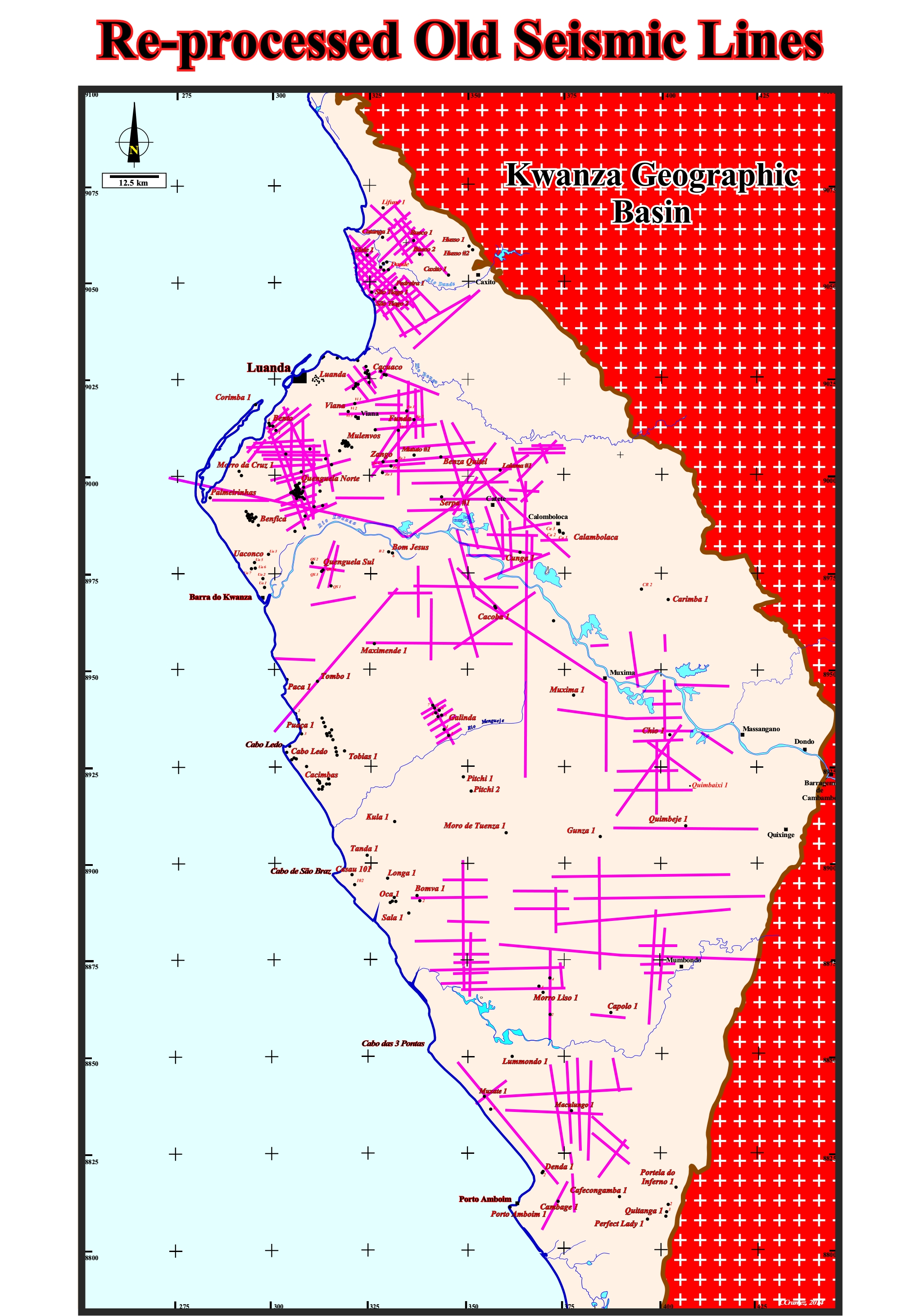
Figure 047- In 2007, Sonangol took the decision of reprocess and migrate the readable data of the old seismic lines shot by Petrangol and Total CAP. However, as can be seen by comparing this map with the previous one (penultimate figure), the majority of magnetic tapes are unreadable. Moreover, as illustrated in next figure, as expected, the reprocessing has not improved, significantly, the infra-salt, since the acquisition parameters of the old lines are not adapted for this purpose. At that time, geoscientists were, particularly, interested in testing the petroleum potential of supra-salt sediments.
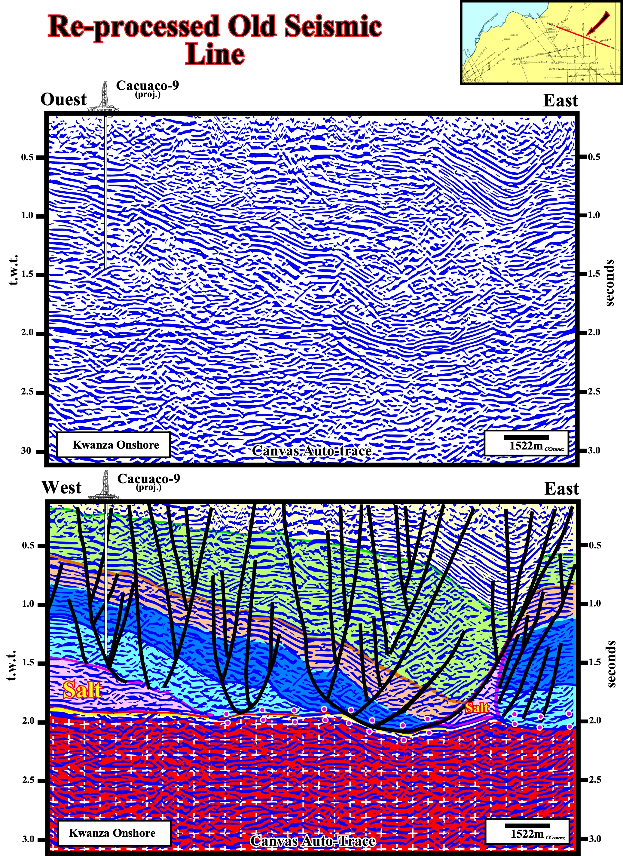
Figure 048- The seismic line shown above, located in Cacuaco area (see location map at the bottom left of this figure), is a reprocessed version of an old seismic line near which was located the well Cacuaco-9. In this line there is a clear improvement in definition and geometry of supra-salt reflectors, which allows a very good picking, particularly of fault planes. In contrast, under the salt, practically there is any improvement. As this is also the case in all other reprocessed lines, it can be said that all infra-salt exploration requires the purchase of seismic lines SKB (2012). The tentative geological interpretation, is temporary. It strongly suggests that the Cacuaco structure (this line shows only the eastern flank of the structure) does not correspond to a structural trap without faults, but to a lateral association of morphological traps by juxtaposition. In fact, today, one can say that the Cacuaco wells did not test a major structural trap, but several discernible (at that time) morphological traps by juxtaposition, which fully explains the results of wells. The petroleum potential of the Cacuaco structure, as well as of the block KON-2, requires, first of all, the geological interpretation of reprocessed seismic data. Moreover, geoscientists must not forget that the vertical scale of the seismic line is in time and not in depth, that is to say, any lateral change in the velocity interval (for example, variation in salt thickness) induces a seismic artifact. Thus, for example, on this seismic line, the margin infra-salt sediments (Cuvo formation in yellow), which appear horizontal is, in reality, dipping westward. Likewise, the synform visible the eastern part of the line is an seismic artefact induced by the presence of an Oligocene-Miocene depocenter.
c) SKB Seismic Grid (2012)
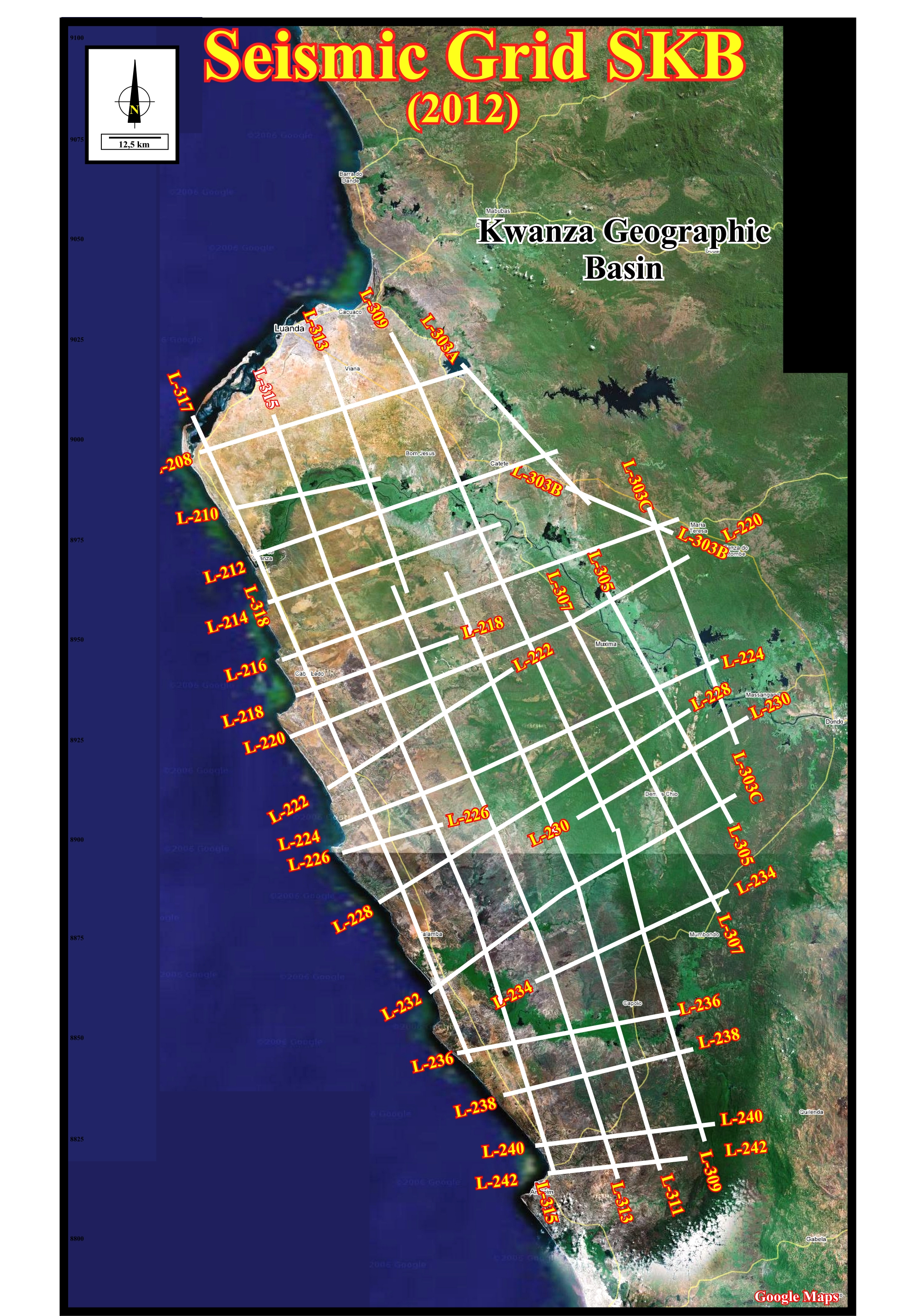
Figure 049- The seismic grid SKB, shot in 2012 is, here, here draw on the onshore Google map of the Kwanza onshore. On average, the distance between the seismic lines is, more or less, 10-15 km, which means that a petroleum prospect with a closed area less than 100 km^2, may not be recognized, which is, particularly true for the infrasalt sediments. In other words, it is illusory to define a drillable prospect just with such a seismic grid. The old lines must be taken into account (for suprasalt prospects) and or a detail campaign must be shot to better define it.
d) SKB Seismic Grid (2012) on Geological Map
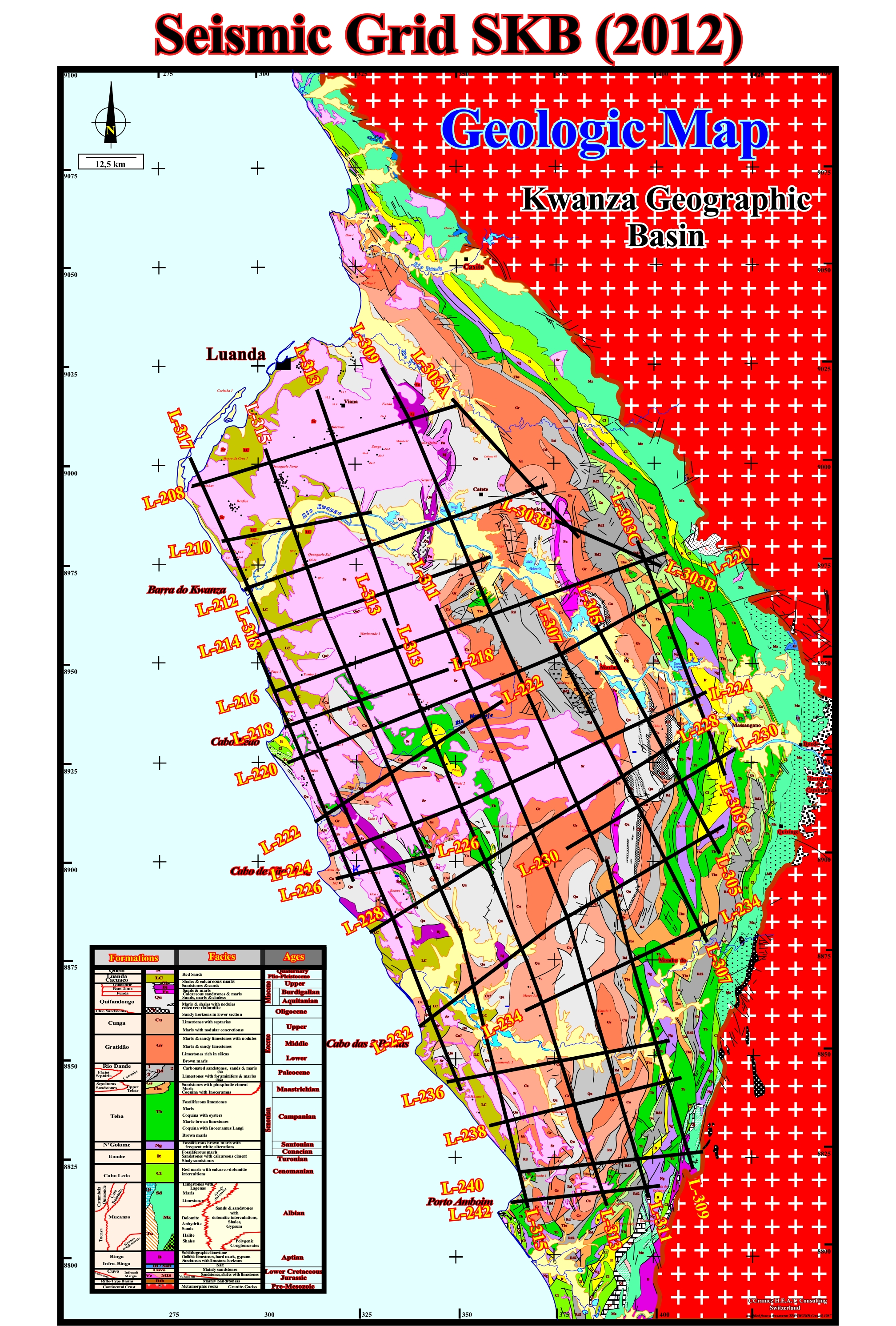
Figure 050- This map will allow geoscientists in charge of tentative geological interpretation of SKB campaign seismic lines (2102) to calibrate (in geological formations) the upper horizons and, particularly, the surface of the data. This is quite important, since the acquisition parameters used, targeting, especially, the infrasalt intervals, the upper levels have a lot of noise.
e) SKB Seismic Grid (2012) on Fracture Zones & Depocenters Map
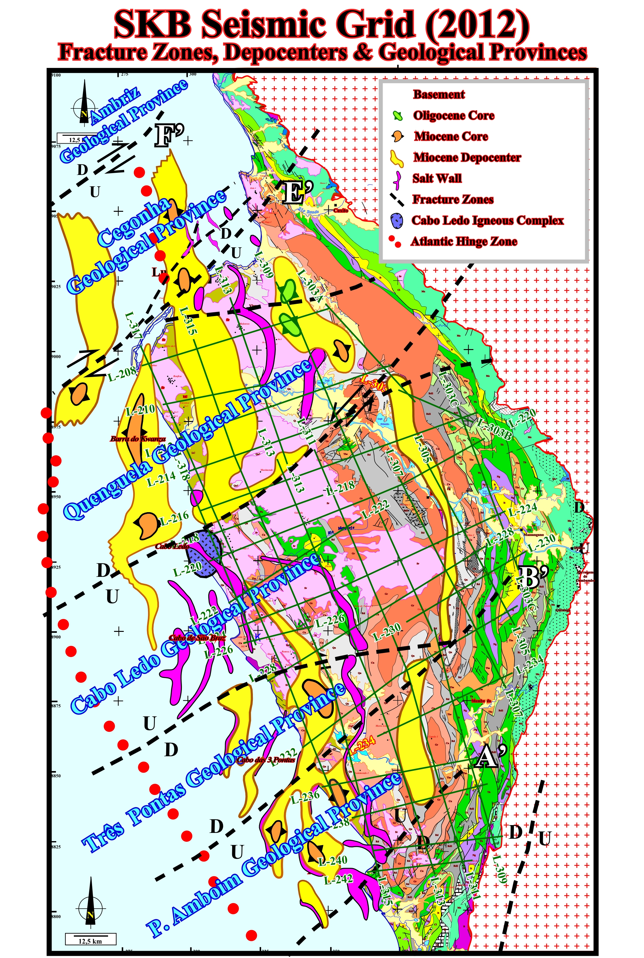
Figure 051- The overlap of the seismic grid and the map of the fracture zones allow geoscientist, in charge of the tentative geological interpretation of seismic lines of the SKB campaign (2012) to be aware the intersection areas (zones of fracture/seismic lines), since in 1-2 kilometers everything can change. This is, particularly, conspicuous in the seismic lines striking NNW-SSE. Furthermore, it indicates the lines where, apparently, there are no sudden changes, at the base of the salt, in substratum or in the salt cover (lines within the same geological province).