
Salt Tectonics has been defined as any tectonic deformation of a sedimentary package involving salt, or other evaporites as a mobile substratum or mobile layer. In this sense, salt tectonics is not a synonym of Halokinesis, which labels a sedimentary deformation powered entirely by gravity, that is to say, by buoyancy, in absence of significant tectonic stress (σt = 0).
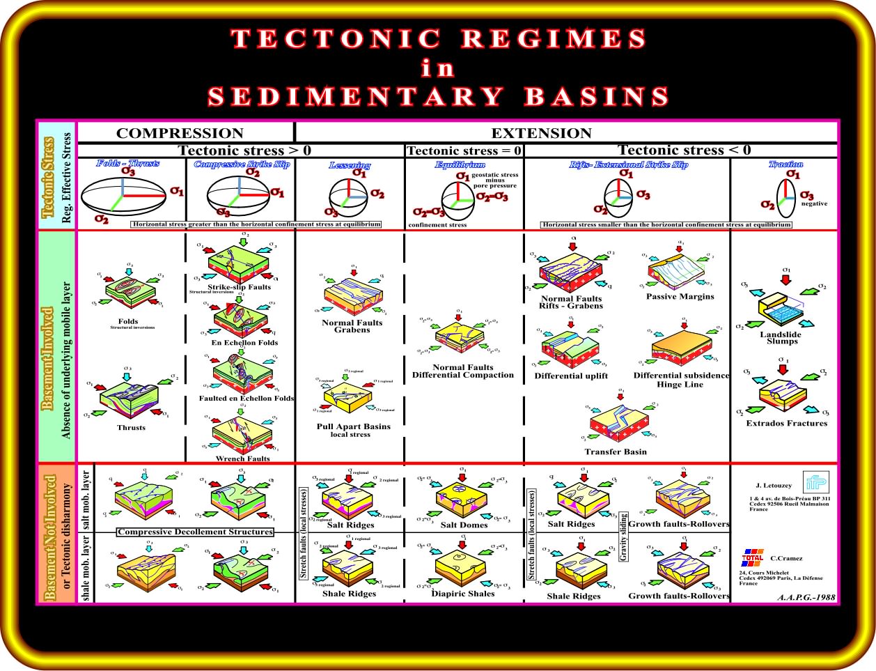
On this tentative of classification of tectonic regimes in sedimentary basins, compression means that sediments were shortened and extension that sediments were lengthened. Indeed, as depicted, it is easy to see that with a tectonic stress positive (σt > 0), the sediments can be lengthened (lessening) and not shortened, when the geostatic pressure is big enough. Consequently,, in order to avoid misunderstandings, it is better to use shortening and lengthening, which are better perceived on the seismic lines. The sediments can be shortened by faulting (reverse faults and strike slip faults) and folding (cylindrical and conical folds) and lengthened by normal faults. A stratigraphic column, in which a salt layer (or an evaporitic layer) is inter-bedded with other rocks, can be deformed in different ways. The deformation depends whether the basement is involved in the deformation and upon the effective stresses ellipsoid, i.e., the tectonic regime, which can change spatially and temporally. A salt layer can be lengthened, shortened, or both, as detailed below. It depends on the geological history of the area.
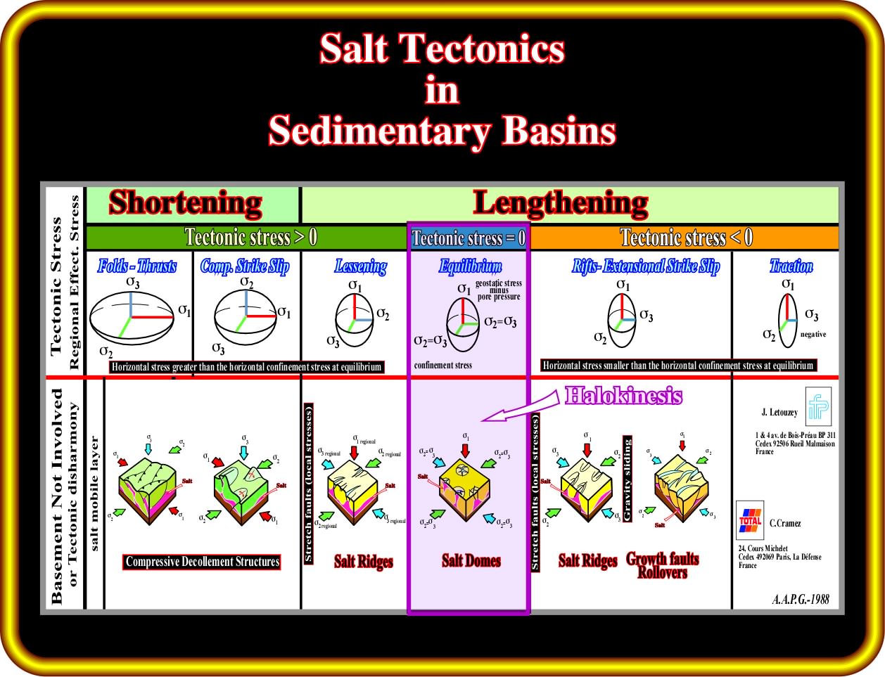
As said previously and as illustrated in this plate, a salt layer (purple on the block diagrams) can be lengthened, shortened, or both. It depends on the geological history of the area. In basins associated with the formation of megasutures (episutural and perisutural basins), generally, the salt layers are shortened with the surrounding sediments. In basins associated with the formation of new oceanic crust (rift-type, cratonic basins and divergent margins Atlantic-type), in which the predominant tectonic regimes are extensional, the salt layers are mainly lengthened, particularly when the basement is involved in the deformation. When the basement is involved, the salt is deformed along with the other rocks, which are lengthened, when σ1 is vertical and shortened when σ1 is horizontal (see previous plate). In addition, when the basement is not involved and in absence of an important tectonic stress (σt = 0), the salt layer can flow (lengthening) by itself deforming the overlying sediments (the overburden, i.e., strata younger than the salt substratum or source layer). The deformation of the salt (overburden included) in absence of a significant tectonic stress is called halokinesis. Let's see few seismic examples.

In Potwar (or Punjab) basin (Pakistan), which, in Bally's classification of sedimentary basin, is considered as a folded belt associated with an A-subduction zone (Ampferer), that is to say, a basin located within the Ceno-Mesozoic megasuture, the predominant tectonic regimes are compressional. All sediments, and partially the basement, were strongly shortened with formation of large anticline structures with reverse and thrust faults. A décollement surface, above the basement, was favoured by the presence of salt layers (Precambrian-Cambrian age) immediately above the basement. The Salt Range Formation (in purple in the cross-section, which has, here, its typical locality, consists, essentially, of an un-metamorphosed sequence of salt, marl, gypsum and dolomite with dominant red gypsiferous claystone without any apparent bedding. The Salt Range formation contains the great mines of Mayo, Khewra, Warcha and Kalabagh, which yield vast supplies of salt. Bituminous shales, dolomite, and oil shale layers are common. As depicted above, the salt layers were shortened in the same way as all other sedimentary packages. In other words, in this area there is no evidence of halokinesis, that is to say, deformation of the salt layers in absence of a significant tectonic stress (σt = 0).
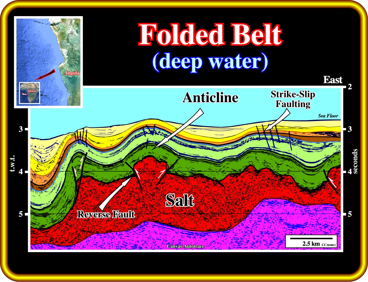
This geological tentative interpretation of a seismic line shot on the deep water Angola offshore, illustrates that a salt layer, independent of its thickness and stratigraphic position (autochthonous or allochthonous), can be lengthened or shortened as any other sedimentary interval following the basic principles of tectonics. In this particular example, taking into account that ta seismic profile is in time and not in depth, it is highly probable that the infra-salt rocks (very likely volcanic crust) was involved in deformation. In the South Atlantic Margins, and particularly in African margins, an Upper Miocene - Pliocene compressional tectonic regime, induced by ridge-push stresses, or by reactivation of the lithospheric plates, shortened the sedimentary pile, as well as, the volcanic crust (SDRs and, or oceanic crust, which postdate the breakup of the lithosphere). Notice, that the small faults, located on the apexes of the anticline structures (they do not exist on the synclines), are not normal faults. They are contemporaneous of the shortening, and so, they are associated with the same tectonic regime that created the anticline and syncline structures. They are small strike slip faults that elongate the anticline structures along their axe (σ2). This tentative interpretation is not refuted, i.e., it is corroborated by time contour maps of the Upper Cretaceous horizon (light green) and by time and depth slice interpretations.
In absence of significant tectonic stress (σt = 0), that is to say, in a tectonic regime characterized by σ1 vertical and σ2 = σ3, salt can flow lateral and vertically creating a compensatory subsidence, which gives accommodation (space available for the sediments) for the overburden. Such a local and differential accommodation induces significant lateral thickness variations in the synkinematic layers of the overburden, which are one of the main characteristics of the halokinesis, as illustrated below.

On this geological tentative interpretation of a seismic line of the conventional Angola offshore, the salt and overburden deformation (turtle back structure) can be explained just by halokinesis, that is to say, by an extensional (lengthening) tectonic regime with a tectonic stress null (σt = 0), characterized by a biaxial stress ellipsoid (σ1 vertical and σ2 = σ3), that several geoscientists call equilibrium tectonic regime. It is interesting to notice that, seismically, the salt layer (in purple in the tentative interpretation) is not laterally continuous ; a salt weld (surface or zone joining strata originally separated by autochthonous or allochthonous salt). A salt weld is a negative salt structure resulting from a complete or nearly complete removal of the salt. The weld can consist of brecciated, insoluble residue containing halite pseudomorphs or salt too thin to be recognized by reflection-seismic data.
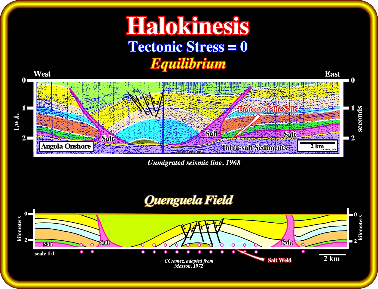
In last century (1968), Petrofina geoscientists, working in Angola onshore (Petrangol), proposed halokinesis (salt flowage with a tectonic stress null) to explain the huge antiform structures (lengthening) recognized, already, in Kwanza onshore by Sinclair's geoscientists by field work (1904-1922). The Quenguela field, the biggest oil field discovered, so far, in onshore Kwanza, was recognized on unmigrated seismic lines as an huge depocenter bounded, laterally, by elongated salt welts (salt antiforms), which are often, erroneously, taken as synonym of salt anticline (genetic term to describe a compressional structure). An antiform is a non-genetic term to describe a bell-shaped geometry. All anticlines are antiforms, but not all antiforms are anticlines. Later, on the 70's, Masson proposed a geological depth cross-section of the Quenguela field, which can be explained by two different geological processus: (i) Minimum stretch with a maximum salt reduction (Masson, 1972) and (ii) Maximum stretch with a minimum salt reduction (Jackson and Cramez, 1989).

Using the old onshore Kwanza seismic lines (shot during the 50's and 60's), geological cross-sections and the results of the onshore exploration wells, Petrangol's geoscientists explained the antiform Quenguela structure as the result of halokinesis with a minimum stretch (S = 1.0) and a maximum salt reduction (SR = 77%). Later, taking into account the geological tentative interpretations of the deepwater seismic lines, Total's geoscientists explained the same structure, also, by halokinesis, but with a maximum stretch (S = 3.1) and a minimum salt reduction (SR = 24%). As we will see all along of this workshop, the more likely interpretations of salt induced structures must take into account the regional geological context, since in the Kwanza basin there are, as illustrated next, at least three different salt regional settings : (I) The Inner Kwanza basin ; (ii) The Coast Arch and (iii) The Outer Kwanza basin.
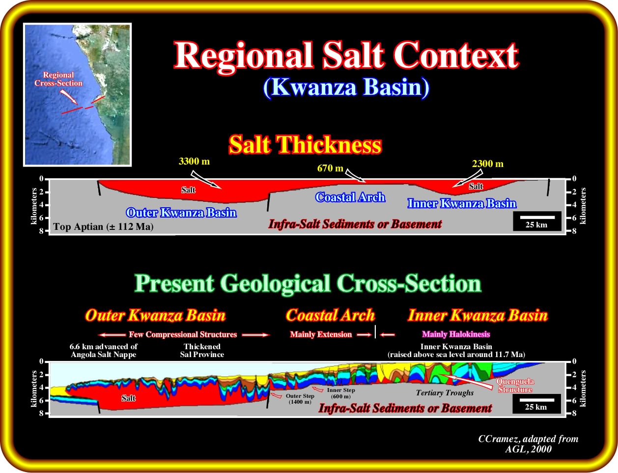
All geological restorations strongly suggest three salt sub-basin with quite different thicknesses : (i) The Outer Kwanza Basin, with a maximum salt thickness reaching around 3300-3500 meters ; (ii) The Coast Arch, which width changes quite a lot (see later), is characterized by a salt thickness less than 100 meters and (iii) The Inner Kwanza basin (raised above sea level during Middle-Upper Miocene), in which the salt layer reached a maximum of 2300-2500 meters. Halokinesis is predominant in the inner Kwanza basin with development of huge Tertiary troughs. Salt tectonics with extension is predominant in the Coastal Arch, in which two principal reactivated salt steps (the outer step with, more or less, 1400 meters and the inner step with around 600 meters) can be recognised. The outer Kwanza basin (westward of the outer salt step) is mainly a compressional realm. In fact, originally, it is thick salt province, which became thicker by tectonic thrusting, which induced an advancement of around 6.6 kilometres (Angola salt Nappe) of the westward limit of the salt basin. Consequently, geoscientists in charge of Kwanza basin petroleum exploration (onshore and offshore) must always place their prospects in the right geological setting since the basic principles of exploration are not the same, i.e., the exploration problems in the inner and outer Kwanza basin are not the same. In the inner Kwanza basin the supra-salt exploration is mature, but the infra-salt exploration is immature or inexistent.
Exercise :

Using this detail of a seismic line of the Angola conventional offshore, propose a tentative geological interpretation, trying to answer the following questions:
(1) Why the sedimentary column is not deformed in the same way ?
(2) The interface between undeformed (or slightly deformed) and deformed sediments corresponds to what ?
(3) Are the deformed sediments shortened or lengthened ?
(4) What is the more likely tectonic regime responsible for the deformation of the sediments ?
(5) How do you explain the antiform structure ?
(6) Do you see downlap reflection terminations on this line ? If your answer is yes, where and why ?
(7) On this seismic line do you recognize potential structural traps (four way dips) ?
(8) Belongs this line to the inner Kwanza basin, Coastal arch or Outer Kwanza basin ?
to continue press
next
![]()
Send E-mail to carloscramez@gmail.com or to carlos.cramez@bluewin.ch with questions or comments about this workshop (Salt Tectonics Workshop for Kwanza and South Congo basin).
Copyright © 2013 CCramez
Last modification: June-July, 2013