
2)Which are the Characteristics of the Salt?
2)Which are the Characteristics of the Salt?
2.1 - Salt, rock salt or halite are general terms for naturally occurring sodium chlorure (ClNa).
The salt or halite is a component of many evaporitic rocks formed by evaporation of salty lakes or seas. It can occur in large layered sedimentary deposits and efflorescences in arid regions. Salt bodies are normally dry and impervious. Halite is associated with various chlorides, carbonates and sulphates (gypsum, sylvite, polyhalite, carnallite, etc.). Geoscientists have a tendency to call salt all evaporitic rocks. Evaporites precipitate from evaporation of saline solutions. The sedimentary rocks composed of minerals precipitated as a result of their concentration increasing in a brine (due to mineral terrigeneous influx or evaporation of the water, in which they are formed). Evaporites are represented mainly by sulfates (anyhdrite, gypsum) and chlorides (halite).

Theoretically speaking a rock salt is a chemical sedimentary rock that forms from evaporation of ocean or saline lake waters. Salt is also known by the mineral name halite. Salt is rarely found at Earth's surface (because it can be dissolved), except in areas of very arid climate. Its chemical formula is NaCl. It can have impurities of gypsum (CaSO4) and sylvite (KCl) but it is very rare to find potassium sulfate as a mineral, although occasionally polyhalite (K2Ca2Mg(SO4)4.2H2O) is found associated with rock salt deposits. Natural salt pans are flat expanses of ground covered with salt and other minerals, usually shining white under the sun. They are found in deserts, and should not be confused with salt evaporation ponds.
2.2 - Crystal system orthorhombic.
2.3 - Cleavage perfect, all sides - cubic.
2.4 - Fracture conchoidal.
2.5 - Colour clear to white.
2.6 - Index of refraction 1.5442.
2.7 - Angle of repose (dry, ASTM D 632 gradation) 32°.
2.8 - Melting point 800.8° C.
2.9 - Boiling point 1 465° C.
2.10 - Hardness 2.5 (Moh’s Scale).
2.11 - Critical humidity at 20 °C.
2.12 - Bulk density is roughly 1.154 (the mass of many particles divided by the total volume they occupy).
2.13 - Density or specific gravity 2.165 (without impurities).
The salt density ranges between 2.15 and 2.17 depending of its composition. The density of the salt formed from evaporation of hydrothermal enriched brines is slightly greater than salt evaporating from meteoric brines.
2.14 - Salt density is constant in depth.
The salt's average density is 2.16 and remains constant with depth. Conversely, the overburden sediments get compacted and density increases from under 2.0, for freshly deposited shale, to 2.6 for shale buried under thousand meters.
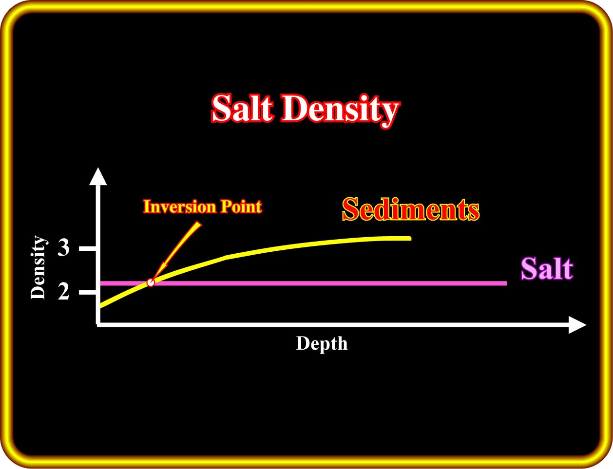
In the shallow part of sedimentary basins, between the surface and, more or less, 1500 meters of depth, the density of the salt, which remains, roughly, constant, is higher than the density of the sediments. However, below the inversion point, the density of the sediments is higher than the density of the salt. In basins with a salt layer two different domains can be considered : (i) An upper domain, in which the salt density is higher that of the density of the sediments, and (ii) A lower domain, in which the density of the sediments is higher than the density of the salt. In a vertical salt-sediments interface (salt dome), within the upper domain, the pressure produced by the salt against the sediments is not balanced by the pressure produced by the sediments against the salt. Consequently, the salt has the propensity to flow laterally. Within the lower domain, the salt has a propensity to flow upward, because, at the same level, the confining pressure in the sediments is always higher than the confining pressure within in the salt. This explains why a salt dome with vertical walls is a physical impossibility. They exist only on inaccurate geological tentative interpretations of seismic data, as illustrated next.

On this tentative interpretation, it is quite easy to imagine three more or less vertical salt diapirs, which due to inversion points, evolve, in the upper part of the seismic line (where the the pressure produced by the salt against the sediments is not balanced by the pressure produced by the sediments against the salt, gives to the salt the propensity to flow laterally) into salt canopy, i.e., in a composite diapiric structure formed by partial or complete coalescence of diapir bulbs or salt sheet. As illustrated above, the coalescent salt bodies may or may not be connected to the salt source layer.
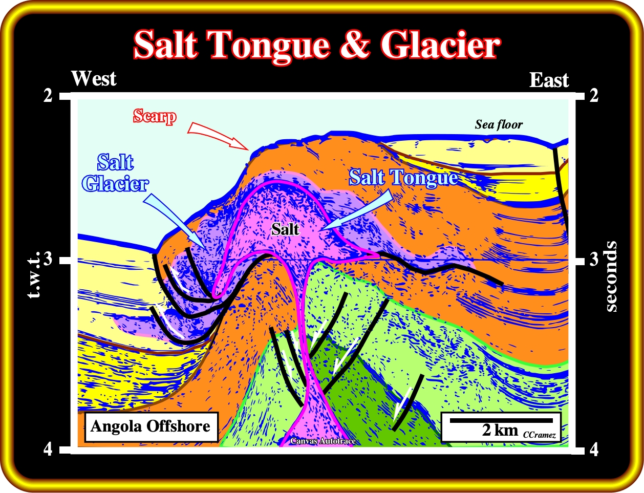
Certain salt tongues and salt glaciers, as those proposed in this geological tentative interpretation, can be, partially, explained by the fact that above the inversion point, that is to say, in the upper part of the sedimentary column, the salt has the propensity to flow laterally. As said previously, contrariwise to the sediments, which become, more and more, compacted with burial, the density of the salt stay roughly constant (difficult to compact), In addition, as it is the case in this example, a local compressional tectonic regime, strongly favour the formation of salt glaciers (synonym of namakier) from an exposed diapir and spreading beneath air or water.
2.16 - Salt velocity varies from 4500 to 5500 m/s.
The seismic waves (P wave velocity) travel in the salt at a velocity ranging between 4500 and 550 m/s, which, generally, is obviously higher than that of surrounding rock. Sub-salt reflections are pulled up intensely due to the great velocity difference between salt and surrounding rock and the thickness variation of salt layer. Taking a salt dome as an example, one can say, the thicker the salt is, the greater sub-salt reflection is pulled up, which makes the sub-salt events appear as pseudo-structural configuration. Consequently, isochronous maps are not able to reflect its true shape. Therefore, the key to sub-salt structure interpretation is determine by the thickness and boundary of the salt dome.
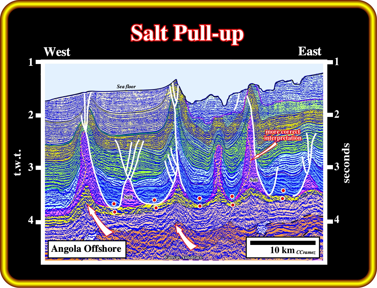
As the density of the salt does not change with the depth, one can say that, the velocity of the seismic waves through the salt is, more or less, constant, i.e., between 4500 and 5500 m/s, which is much higher than that of the surrounding sediments. When a salt dome or an abrupt change in the thickness of the salt layer is present a phenomenon of relative seismic velocities of strata whereby a shallow layer or feature with a high seismic velocity surrounded by rock with a lower seismic velocity causes what appears to be a structural high beneath it. In this particular example, the bottom of the salt layer as well as the infra-salt sediments are pulled-up below the zones of thicker salt. In other words, the undulations of the infra-salt sediments have no geological meaning. In fact, in a depth converted seismic version, the infra-salt horizons have a more or less constant westward dip. Notice that this tentative interpretation do not respect the influence of the salt-sediments density inversion (a vertical salt-sediment interface is unlikely). An alternative picking of interface salt-sediments is, locally, proposed (yellow dashed line),
2.15 - Salt plasticity (under 50-150 bars) is function of the thickness of the salt and overburden.
As the salt thickness and/or the thickness of the overburden increases, the salt turns from elastic (deformation reversibly under stress) to plastic (permanent deformation under loading) in an unstable status, tending to flow lateral or vertically. Salt undergoes no permanent deformation if the applied stress is smaller than a characteristic yield stress. It flows readily when the applied stress is at, or slightly above, the yield stress. Mathematically, one can idealize plastic behaviour assuming that there is no deformation at all (rigid material) below the yield stress and that during deformation, the stress cannot rise above the yield stress except during acceleration of the deformation. Salt deformation starts beyond a certain pressure threshold, ranging, roughly, between 50 and 150 bars, depending on the nature and composition of the salt.
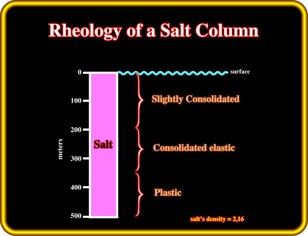
Theoretically, in a salt column of 500 meters, assuming a salt’s density of 2,15 the σ vertical of the geostatic pressure (σg) at 230 meters depth (at a given point, the geostatic or lithostatic pressure, which corresponds to the height of the rock column, can be represented by a vertically oblong biaxial ellipsoid), is 50 bars, while at the bottom, it is around 107 bars. Plastic salt deformation can occur within a salt layer even in the absence of overburden. In rheologic terms, a column of 500 meters of salt, can be considered as a vertical superposition of three salt intervals: a) Plastic ; b) Consolidated elastic and c) Slightly consolidated. In other words, in absence of a tectonic stress and a significant overburden thickness, salt deformation is possible due to the geostatic pressure of the upper salt intervals. In fact, it is difficult to mention buoyancy to explain movements within the salt, since density of the salt is constant in depth.
2.16 - Solubility of the Salt varies with the temperature of water
Whether the salt (sodium chloride) dissolves is determined by which attractive force is stronger. If the internal ionic forces in the crystals are the strongest, the salt does not dissolve. This is the situation in reactions where precipitates form. If the attractions for the ions by the polar water molecules are the strongest, the salt will dissolve. The solubility of the salt, in grams per 100 grams of water (g/100g), under 1 atmosphere pressure, varies with the temperature of water (35.65 at 0°C to 38.99 at 100°C).
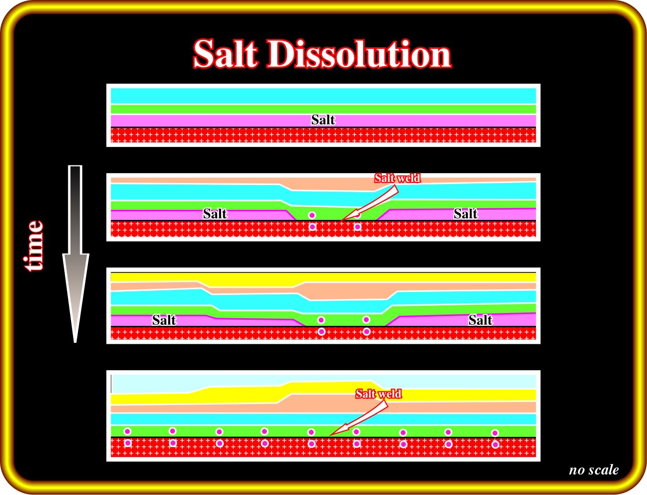
This sketch, taken from Arbenz (1968), suggests one of the more likely hypotheses explaining particular antiform structures, in North Sea. In Arbenz’s hypothesis, successive salt dissolutions transform a continuous and isopachous salt layer into a wide salt weld with development of the antiform extensional structures in the overburden. Alternative hypotheses have been proposed. However, Arbenz’s hypothesis is, by far, the more difficult to refute. Salt dissolution or volume loss is one the processus of salt reduction. Lateral flow is also a processus of salt reduction (see later).
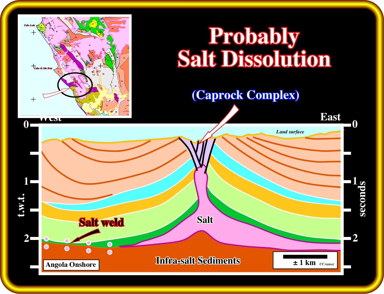
The geological map of Kwanza basin (onshore) strongly suggests that the more likely area where salt dissolution took place is eastward and southward of Cabo St. Braz. This conjecture seems to be corroborated by the results of Longa, Bomva and Oca wells. This geological tentative interpretation of an old seismic line suggests that a collapsed zone, by dissolution, in the top of diapiric salt walls (elongated up-welling of diapiric salt) of a complex caprock. Such a complex caprock corresponds to an impervious body of anhydrite and gypsum, with minor calcite and sometimes with sulphur, that overlies a salt body or plug. It probably results from accumulation of the less soluble minerals of the salt body during leaching in the course of its ascent and exposure. A caprock can produce a sharp positive anomaly superimposed on a broader negative (caprock effect), indicative of a salt dome. Quite often the cap rock material is denser than de salt, which is the case in this example (take into account the uplifted of the overburden). However, as very shallow salt is denser than the surrounding sediments, the caprock effect is not significative.
When a salt dome is not outcropping but covered by a relatively thin and permeable sedimentary interval, its roof can be washed. Geoscientists call this subrosion. The role of the fractures above a salt dome is quite important. It controls the shape, development and verticality of the walls of subterranean dissolution basins. A depocenter is gradually created over the permeable cover, whereas leaching creates a more or less horizontal salt-cover interface.
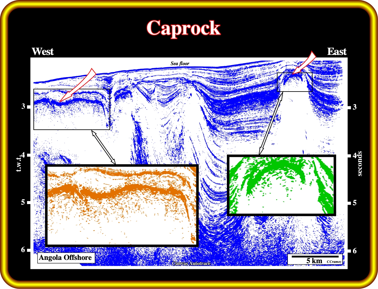
On this seismic line of the Angola deep offshore, the presence of a caprock on the top of the salt structure is obvious. A caprock or cap rock is a harder or more resistant rock type overlying a weaker or less resistant rock type. Common types of caprock are sandstone and ultramafic rock types. In processes such as scarp retreat, the caprock controls the rate of erosion of the scarp. As the softer rock is cut away, periodically, the caprock shears off. Caprock is also found on the top of mesa formations. In Kwanza basin, caprocks are associated mainly with the tops of salt domes. They are dissolve in a characteristic manner, and can range between 0–300 meters. In fact, the halite (salt) is removed first, leaving behind gypsum and anhydrite. The anhydrite and gypsum react with organic material to form calcite.
2.17 - Flowage of the Salt.
Whenever a salt interval is too thick or overlain by overburden whose average density exceeds that of the salt, there is a mechanically unstable situation. Different geological situations can be considered:
Isopachous and Homogeneous Overburden
In absence of overburden, whenever the difference in pressure (P) between two given points, not very distant, within a salt layer (with plastic properties), is zero, there is no salt movement. The same is true when the overburden is isopachous and homogeneous.
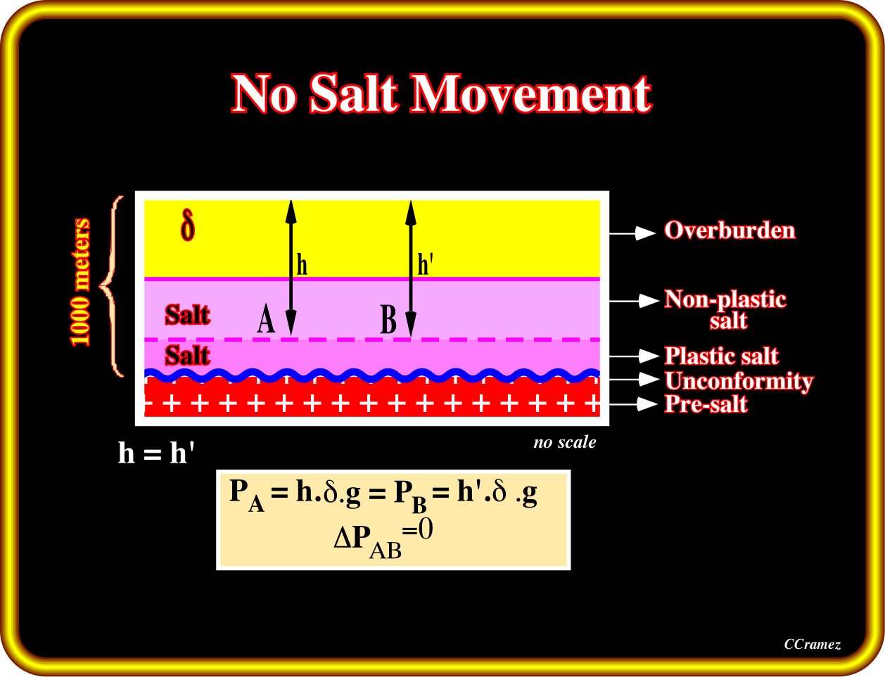
The lithostatic pressure in A and B is the same. There is no pressure difference at the top (or bottom) of the plastic salt layer. Therefore, in absence of significant tectonic stress, under such conditions, no salt movement is possible. As illustrated, even if the thickness of the salt interval is relatively small, the loading of the overburden can be enough to create, within the salt layer, two intervals with different rheologies : (i) An upper interval with a non-plastic behaviour and (ii) A lower interval with plastic behaviour. In the lower salt interval, the salt can flow laterally, if, at same depth, there is a different pressure between two points A and B. However, when the salt and overburden are isopachous and homogeneous, the lithostatic pressure (σg = P = h.d.g, where h = depth of the given points, d = average density of the sedimentary column above the given points and g = the gravitational constant), at the given points, is the same. Consequently, there is no salt movement or salt flowage.
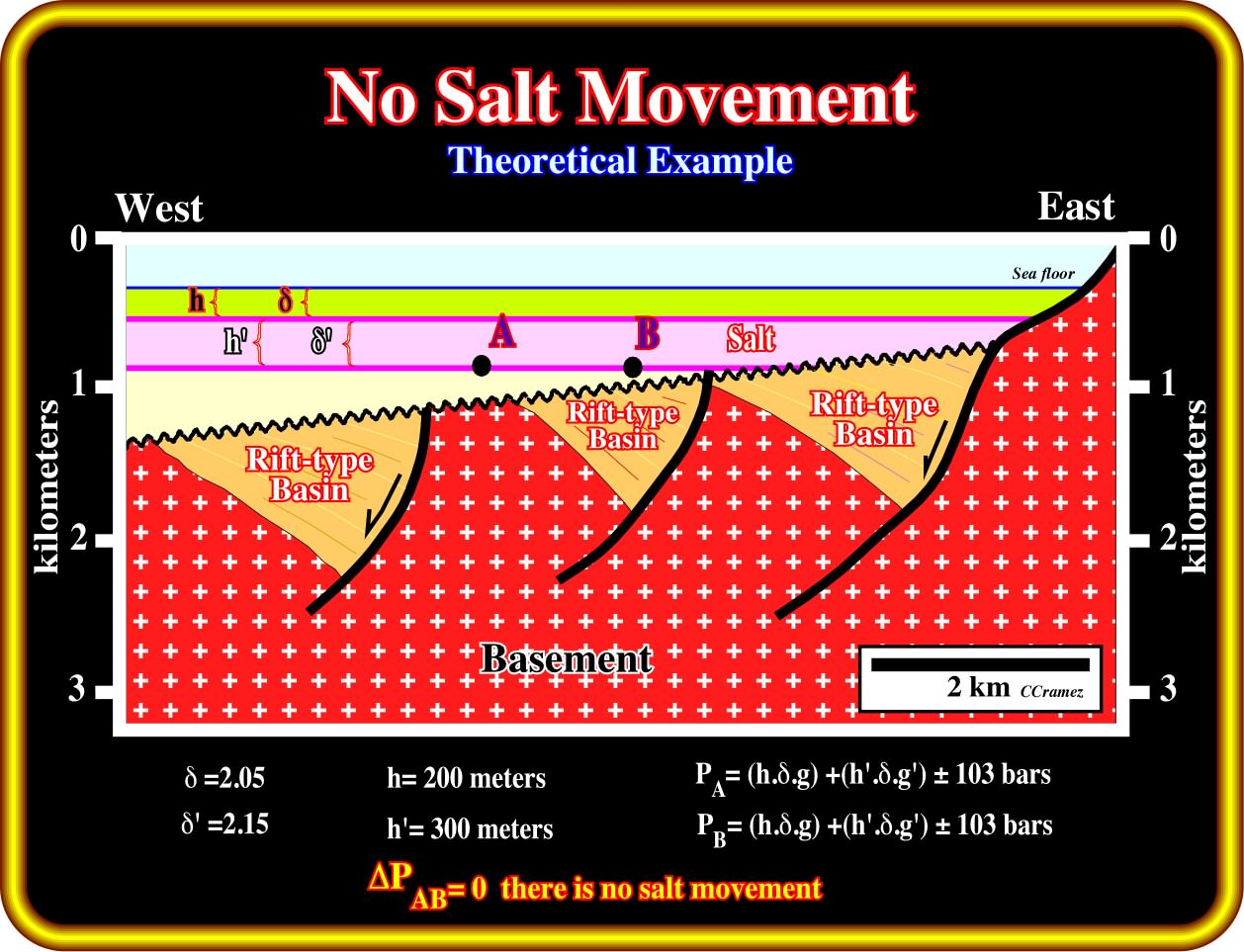
Theoretically, the geostatic pressure at points A and B, located at the base of the salt interval, is the same. Therefore, in absence of a significant tectonic stress, there is no salt movement. There is no difference in pressure in isobaths within the salt layer. Such a geological situation is difficult to find in divergent continental margin, as in Kwanza offshore, due to the general westward tilting of the basin. However, in the Kwanza onshore and particularly in the coastal arch, between the outer and inner Kwanza basin, in which the westward tilting is quite small, it is possible to find, locally, zones of almost no salt movement, is spite of the fact that halokinesis is there quite active. On this subject the new onshore seismic data can be very instructive.
If a difference in pressure (ΔP) exists between two not very distant points, and in same isobath, within a salt interval with plastic properties, salt movements can take place. In subsurface, salt movements occur when the force (f) created by difference in pressure (?P), between two points, is greater than zero. However, ΔP must overcome :
(i) The friction, at the base of the salt, and
(ii) The resistance of the overburden.
When the thickness of the overburden or the water depth, changes laterally, within a plastic salt interval, salt can flow from high-pressure to the lower pressure areas. Such geological conditions are quite frequent in sedimentary basins, particularly in divergent margins whether Atlantic or non Atlantic-type. The sedimentary prism become condensed seaward (geological conditions of starved basins) and the water depth increases, strongly, basinward of the shelf break. Contrariwise to Atlantic-type continental margins (as in Angola), the divergent margins non Atlantic-type are those developed in basins associated with the formation of the megasutures (compressional setting), particularly when extension is big enough to break-up the lithosphere and initiate sea floor spreading.

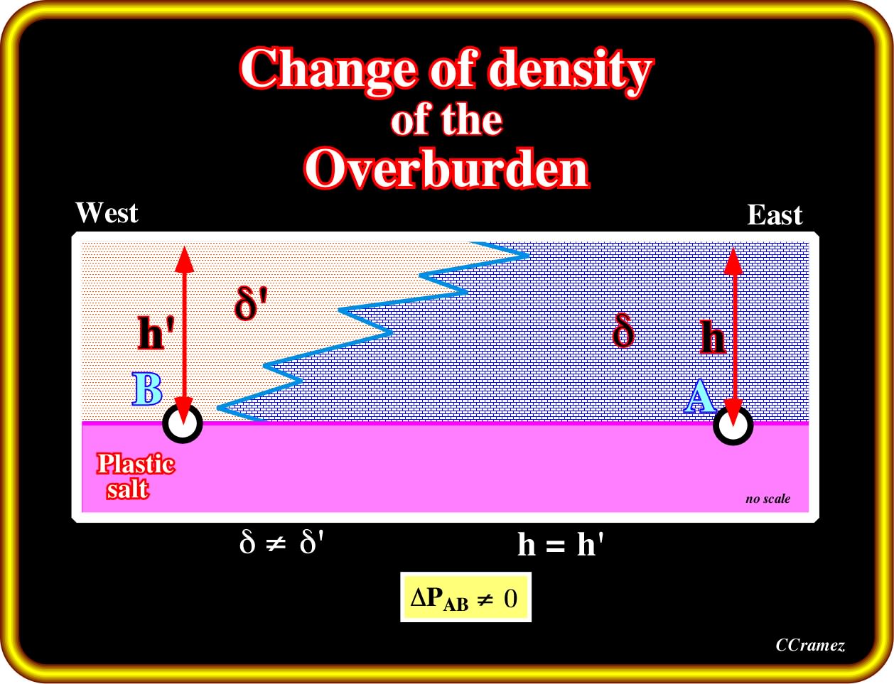
Assuming a more or less constant density of the overburden, which is quite rare, a progressive increasing of the water depth, and a plastic salt layer, it is always possible find two point (A and B), not too distant, on the top of the salt or within the salt, with a different of pressure (ΔP) big enough to induce salt flowage from A (high pressure) to B (lower pressure). Similar salt displacement can be induced just by density variation (change of facies) of the overburden.
This geological tentative interpretation strongly suggest that salt flowage starts immediately after the deposition of the dark blue interval (carbonates), which, progressively, thicks continentward. Such a landward thickening (retrogradational geometry), probably associated with a transgressive episode, implies a westward increasing of water depth. So, probably, the variable thickness of the overburden (dark blue interval) and the westward increasing of the water depth forced the salt to flow seaward creating a compensatory subsidence responsible of the thickening, against the normal faults, of the light blue interval.
A lateral density or facies change of the overburden can also induce salt flowage. In the South Atlantic margins, during the initial stage of the sea floor spreading, shelf-carbonates and slope shales composed, mainly, the overburden. Therefore, and independently of the water depth, the change in facies between the shelf and slope environments is a major factor to create a down-dip salt flowage. In spite of the fact that the overburden is often composed by compacted strata (carbonate or sandstone), it must be noticed that such rocks are, readily, fractured by traction. Compressive and tensile strength of the overburden must be taken into account to better understand the associated salt structures.
In the offshore Angola, the seaward changes in environment and facies had an important influence on the salt tectonics. As illustrated on this geological tentative interpretation, during the transgressive phase of the Post-Pangea continental encroachment cycle, the backstepping geometry forced the majority of the salt layer to flow down-dip, since the thickness of the overburden increased landward as facies changes from shales (slope environment) to carbonates (platform environment). At the present time, only a few salt rollers can be recognized in the footwall of the growth faults induced by the salt flowage. At deposition time, the thickness of the salt, in time, was at least of 200-300 milliseconds.
In all Atlantic-type continental divergent margins, physically speaking, a tectonic tilting (salt layer included), is equivalent to a thickness variation of the pre-tilting overburden.
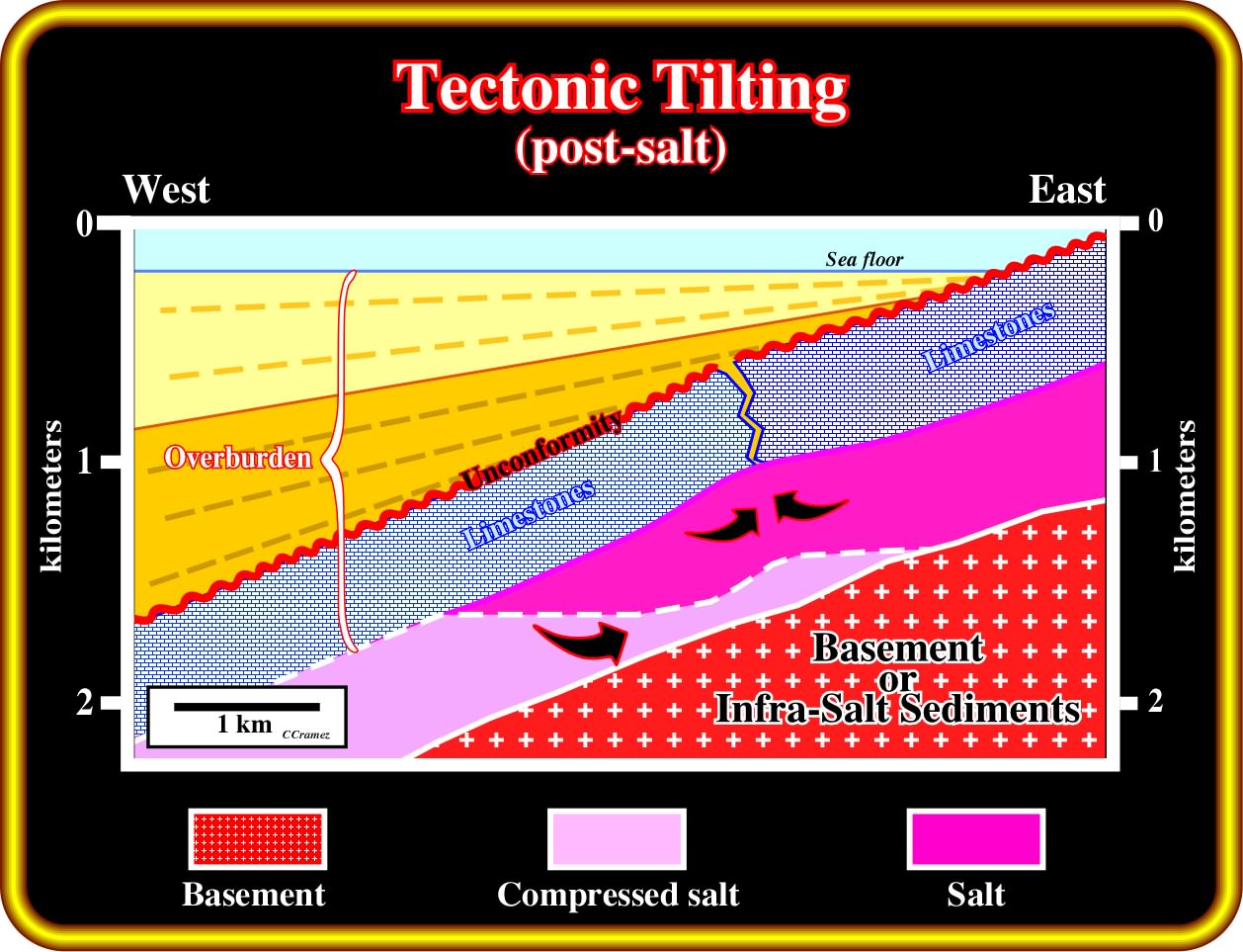
Salt movements can start with a seaward tectonic tilting. Due to such tectonic tilting, within the salt, a ΔP between two points, not too distant and small positive anomalies can be created at the top of the salt. Such salt anomalies can break (lengthening) the pre-tilting overburden by traction, particularly when the facies is calcareous, since the compressive strength in a limestone is 200 / 300 kgf/cm2 and the tensile strength is around 15 / 29 kgf/cm2), i.e., much smaller than in a sandstone facies. Notice that in this sketch the tectonic tilting (unconformity) is fossilized by the onlaping of the post-carbonate sediments.
However, when the top of the salt layer has a tectonic dip, the salt moves in a direction, which depends on the average density of the overburden :
(i) Overburden less dense than the salt
When the average density of the overburden is lesser than that of the salt, the salt moves down-dip, as illustrated below.
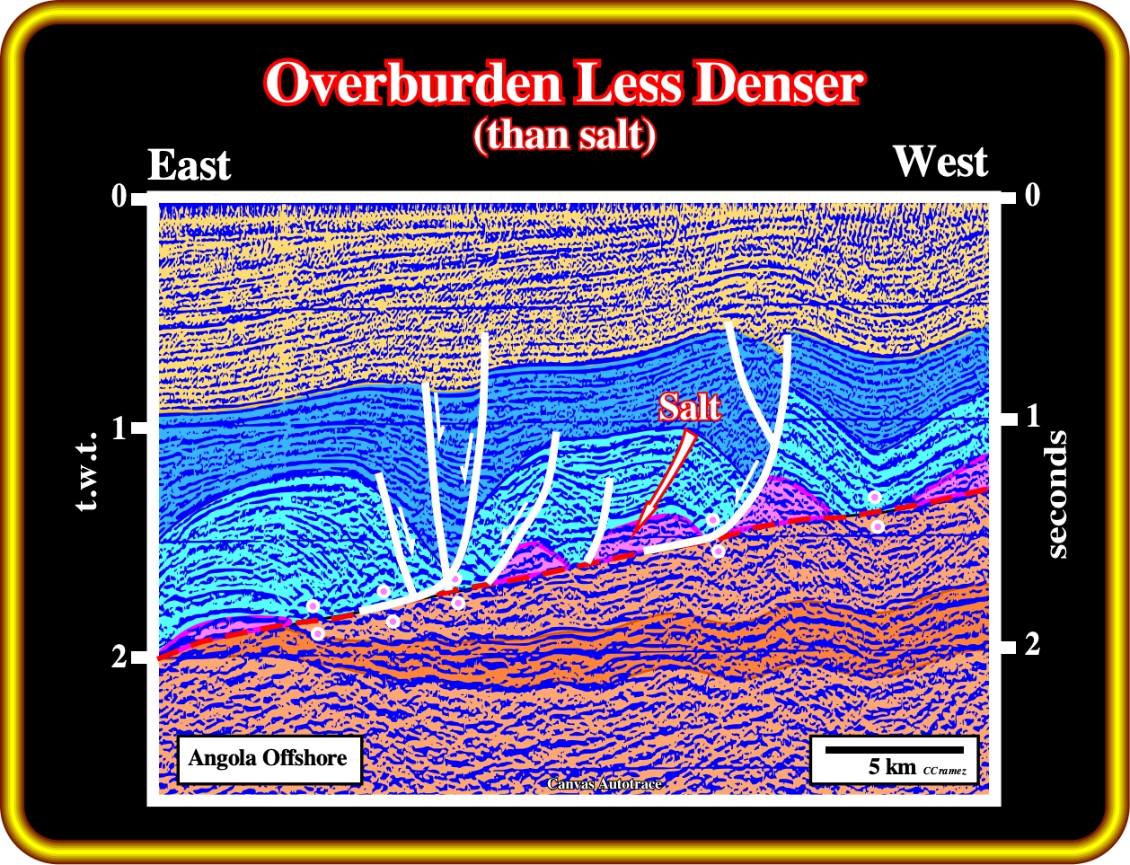
The down-dip salt flowage, recognized on this geological tentative interpretation, is mainly due to the seaward tilting of the margin and to the fact that the overburden is, in average, less dense than the salt. In addition, as shown previously, the changing in environment and facies have, also, contributed to the salt movement, which locally, created an important compensatory subsidence (see thickness variation in blue interval).
(ii) Overburden denser than the salt
When the average density of the overburden is greater than the density of the salt, the salt moves up-dip. For an overburden thicker than 1500 / 2000 meters, that is to say, below the inversion point, the average density of the overburden is higher than 2.15, thereby the salt tends to flow up-dip. Nevertheless, if salt movements are initiated under much less thick overburden, the salts, can eventually, flow down-dip.
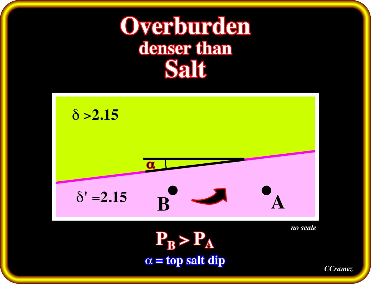
When the overburden is denser than the salt, the salt moves up-dip. The geostatic pressure in point B is higher than in the point A. At the same isobath, sediments with high density replace a certain height of the salt. Up-dip and down-dip movements are predominant in the onset of the halokinesis. Later, they lose relevance; the tectonic stress becomes significant and the effective stresses ellipsoid become.
So far, in Kwanza basin, as well as in South Congo basin, we have not seen a clearly continentward flowage of the salt induced by a denser overburden.
2.18 - The Thermal Conductivity of the Salt is around 5-6 W / m /K.
Thermal conductivity of the salt (halite) is around 5-6 W 1/m 1/K, i.e., higher than in shales (1-3) and sandstones (2-5), which is quite important for the maturation of the organic matter. In fact, the understanding of the time and place of maturation of source-rocks for petroleum generation requires an understanding of past geothermal gradient, which we have to estimate, since we can't go back in time to measure those geothermal gradients. Attempts to estimate past geothermal gradients commonly involve modelling of the flow of heat through layers of sedimentary rock.
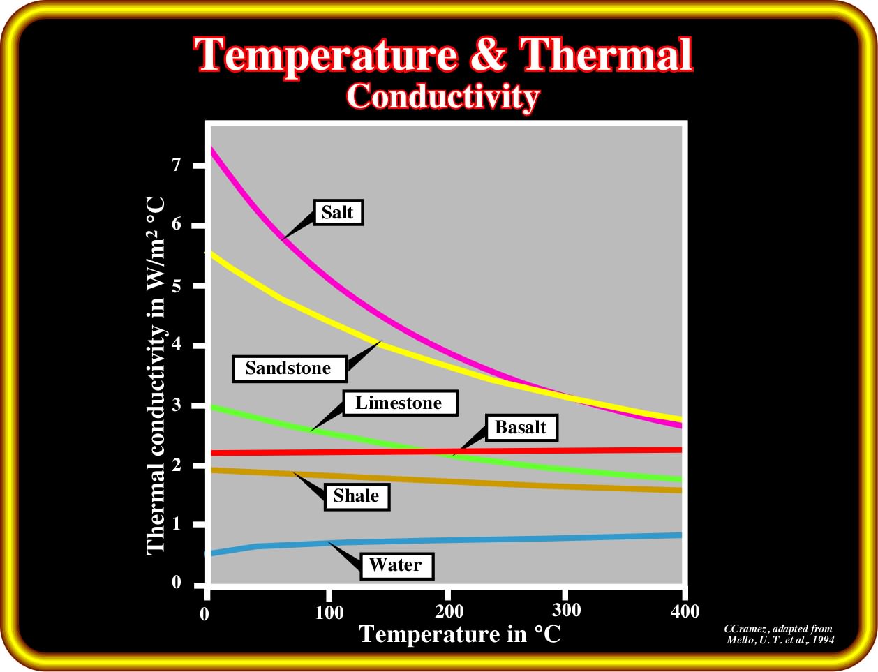
If one can make a reasonable assumption about the past heat flow in a sedimentary basin, one can use the thermal conductivity of the strata in the basin to calculate the geothermal gradient at any given time and thus estimate the past distribution of temperatures. Thermal conductivity data show that shales have small values, whereas more quartzose siliciclastics and purer carbonates have greater values. Values are greatest for halite.
If, for you, the relationship between thermal conductivity and geothermal gradient is not intuitively obvious, remember that when you take a hot item from the oven, you want a steep thermal gradient between that item and your hand (you want that item hot and your hand cool). To do that, you put a hotpad (an insulator and thus an object with a small thermal conductivity) between the hot item and your hand to enforce the desired large thermal gradient (Railsback's Petroleum Geoscience and Subsurface Geology). The same happen in the ground, during maturation of the organic matter of the potential source-rocks, where salt layers play an important role, as illustrated below.
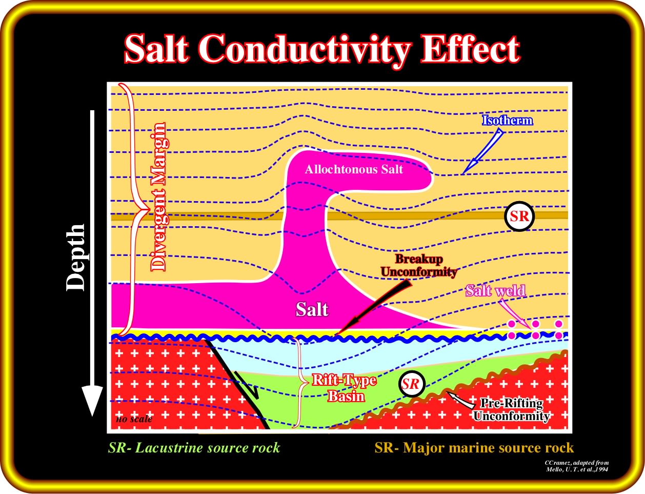
As illustrated in this sketch, due to the high thermal conductivity of the salt, the isotherms rise above and drop below a thicker salt. In other words, the maturation of the organic matter of rift-type basin sediments, covered by a thick salt layer, is slow down since the salt layer absorb a lot of heat (the isotherms go down), Conversely, the maturation of the organic matter of potential source-rocks located above a a thicker salt is accelerated, since the salt transfer upward a lot of heart, i.e., the isotherms go upward as illustrated above the salt dome.
Exercise 1 :
Criticise the proposed geological tentative interpretation. Remember that in Geology, and particularly in the geological interpretation of the seismic lines - Theory precedes Observation - that is to say, the theory is assisted by observations and the observations controlled by the theory. Then answer the following questions :
(i) Are the sediments shortened or lengthened ?
(ii) What is the more likely tectonic regime, responsible for the deformation of the sediments ?
(iii) Taking into account that there are three geological salt settings in Kwanza basin (Inner Kwanza Basin, Coastal Arch and Outer Kwanza basin), in what setting do you place this seismic line ?
(iv) Why the green interval (limestones), overlying the salt and a salt weld, is more or less isopach ?
iv) Why the bottom of the salt (top of the violet interval) is higher in the middle part of the line ?
(v) Do you think that the green interval is present in the depocenter ? Why?
Exercise 2 :
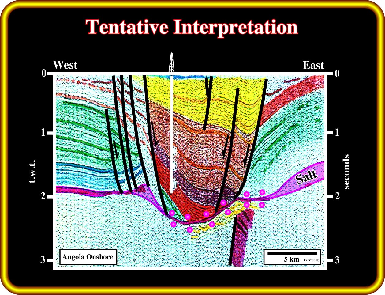
You are not supposed to agree with this geological tentative interpretation of a seismic line from Angola onshore. Please criticize it. Do not forget that there is not veracious geological interpretations. There are not real facts free from theory and conversely, there is no pure theory evolving independent of empiricism. Then, answer the following questions :
(i) Why the bottom of the salt is not rectiligneous ?
(ii) Why the majority of the seismic intervals do not exist in the area bounded by normal faults with opposite vergence ?
(iii) What is the more likely tectonic regime responsible for the sedimentary deformation ?
(iv) Do you thing that the exploration well (Banza Quitel ≠ 1) is well located ? Why ?
(v) Knowing that the facies (lithology) of depocentre, located above the salt weld, is an alternation of sands and shales, where do you locate the more likely sandprone reservoirs-rocks ?
(vi) Make a geological sketch depicting the formation of the salt weld and Tertiary depocentre.
Exercise 3 :
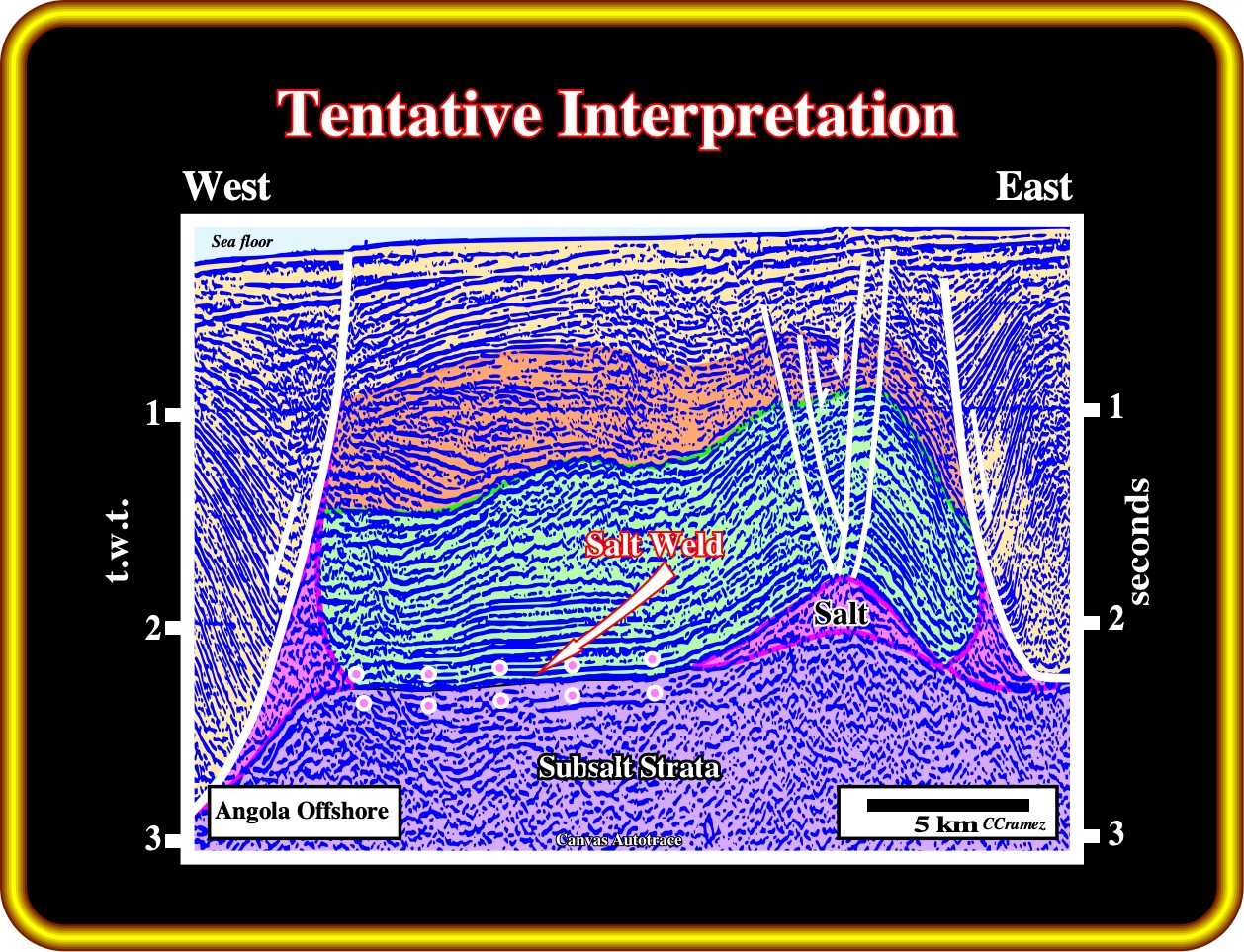
Propose a tentative geological interpretation of this seismic line of the Angola conventional offshore, taking into account the following questions :
(i) Are the sediments shortened or lengthened ?
(ii) Why the sediments below the seismic marker associated with the bottom of the salt are almost undeformed and those above the salt are strongly deformed ?
(iii) Why the tectonic disharmony associated with the bottom of the salt is in the right at around 1.2 seconds depth and at around 2.5 seconds in the left end ?
(iv) Are the reflection terminations at the sea floor onlaps or toplaps by truncation ?
(v) If there is an uplift of this part of the margin, what is, more or less, its amplitude and age ?
(vi) Can you explain the salt induced structures just by halokinesis ?
(vii) Using the different post-salt sedimentary packages as relative age reference, at what age the salt started to flow?
(viii) Finally, can you please, indicate the chronostratigraphic lines along which different sedimentary environment can be recognized.
to continue press
next
![]()
Send E-mail to carloscramez@gmail.com or to carlos.cramez@bluewin.ch with questions or comments about this workshop (Salt Tectonics Workshop for Kwanza and South Congo basin).
Copyright © 2013 CCramez
Last modification: June-July, 2013