
3) What is the Origin of the Salt?
Circumstantial evidence for the association of Aptian evaporites with basaltic volcanics is supplied by evaporite geochemistry and mineralogy, based on the work of Hardie (1983, 1990, 1996). Halite deposits can form by evaporation of either seawater (an abundant source but critically dependent on sea level) or hydrothermal water (possibly less abundant but largely independent of sea level). The geochemistry of rock salt is rarely diagnostic to distinguish between these two brine sources.
However, potash evaporites are much more diagnostic of their brine source. They form two groups:
a ) A rarer group rich in MgSO4 forms by evaporation of seawater originating from rivers. The sulphate minerals, polyhalite, kainite, and kieserite, are diagnostic. This group formed in the Vendian, Late Mississippian to Permian, and Miocene to Quaternary.
b ) The second, more common group is rich in KCl and CaCl2 and poor in MgSO4. This group cannot form by evaporation of seawater from rivers alone. The chloride minerals, sylvite, carnallite, tachyhydrite, and bischofite are diagnostic. This group formed in the Cambrian through Early Mississippian and Jurassic through Paleogene. CaCl2 brines that concentrate to form KCl minerals originate from brines enriched in CaCl2 by hydrothermal water-rock interaction.
The most suitable host, to form brines rich in KCl and CaCl2 and poor in MgS04, is basalt altered to spilitic greenstone. Albitization releases Ca into the brine, and chloritization absorbs Mg from the brine. As the brine wells up hydrothermally, the abundant Ca combines with any SO4 present to precipitate gypsum at the surface. The brine in lakes remains enriched in Ca.
Other host rocks are also possible. Brine can interact with plagioclase-bearing arkoses or with Ca-smectites in redbeds. Limestones would also be a prolific source of Ca, but these are rare below the Aptian salts of the South Atlantic, which is not the case for sub-aerial volcanic rocks, as illustrated below.
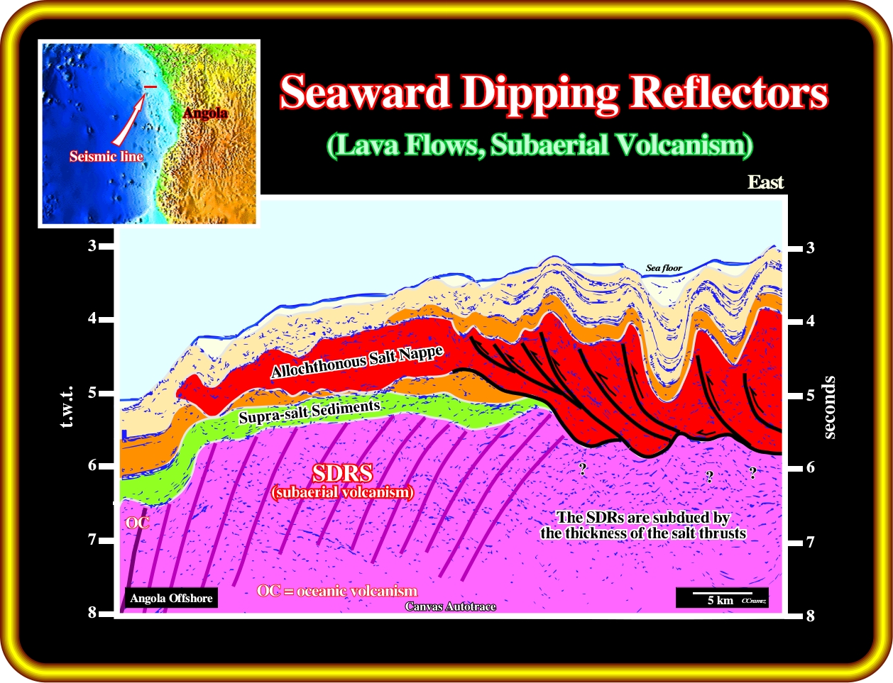
On this geological tentative interpretation of a seismic line of the Angola deep offshore, it is quite evident that, at least, in western border of the salt basin, the substratum of the salt corresponds to subaerial volcanism, i.e., to seaward dipping reflectors as geoscientists call such lava flows emplaced immediately after the breakup of the lithosphere (end of the lengthening of the lithosphere, during which the basins type-rift are developed). Consequently, an hydrothermal water-basalt interaction can explain the potash evaporites rich in KCl and CaCl2 and poor in MgS04. Take into account that this seismic line being in time, the bottom of the salt, in the eastern part of the basin, is must deeper that the top of the SDRs in central and western part of the basin.
The presence of tachyhydrite and similar chlorides does not prove the bedrock near the evaporites was basalt. The vast thickness, high temperatures, and abundant plagioclase in flood basalts mean that these will be the most prolific sources of Ca for the CaCl2. All of the known Aptian potash evaporites in the South Atlantic formed from CaCl2 brines enriched by hydrothermal alteration. The Sergipe-Alagoas Basin contains carnallite and tachyhydrite tens of meters thick. Aptian evaporites in Gabon contain carnallite-bischofite (Teisserenc and Villemin, 1989).
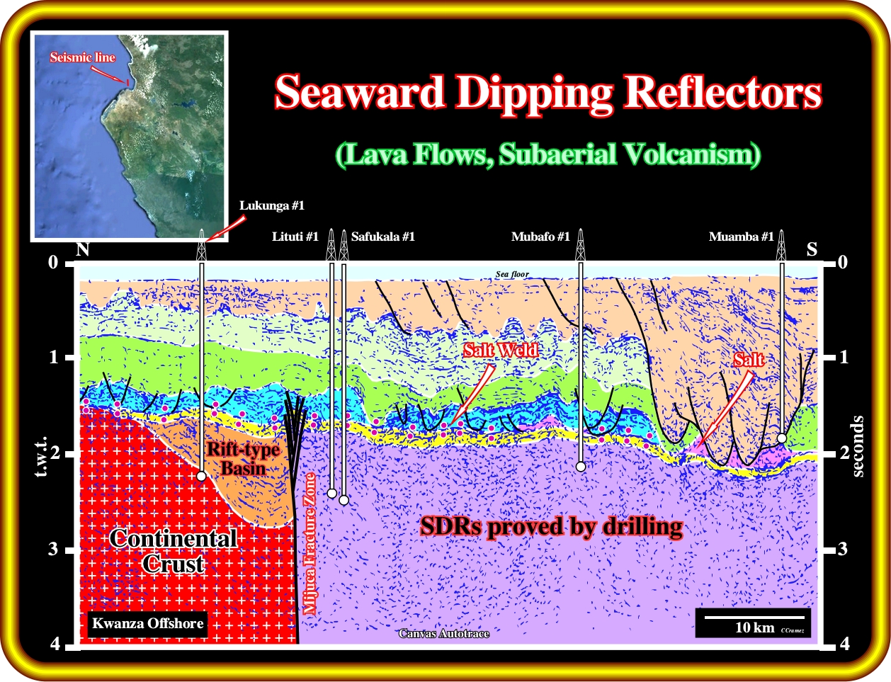
On this tentative interpretation of a seismic line of the Angola conventional offshore (water depth less than 200 meters), westward of a fracture zone striking NE-SW, the presence of a volcanic subaerial crust is, seismically, difficult to recognize, since this lines is perpendicular to the SDRs. However, not only the lines perpendicular to this one show evidence de SDRs, but the results Lituti ≠1, Safukala ≠1 and Mubafo ≠1 wells are conclusive. So, here again, the brines could be enriched by hydrothermal alteration of the volcanic substratum. In this area, between the salt layer and the subaerial volcanic crust there is a relative thick post-breakup sand-shale interval. In others areas, such a sand-shale interval can be under seismic resolution (particularly along the Coastal Arch), and in others quite thick with a potential generating and entrapment petroleum sub-systems (Inner Kwanza Basin and Outer Kwanza basin).
The Lower Congo Basin contains carnallite-sylvite with bischofite-tachyhydrite 150 m thick. Moreover, Pb-Zn-Cu mineralization was widespread during the Early to mid Cretaceous along the South Atlantic margins. CaCl2-rich brine is typically enriched in base metals because it contains roughly eight times (8x) more chloride than seawater.
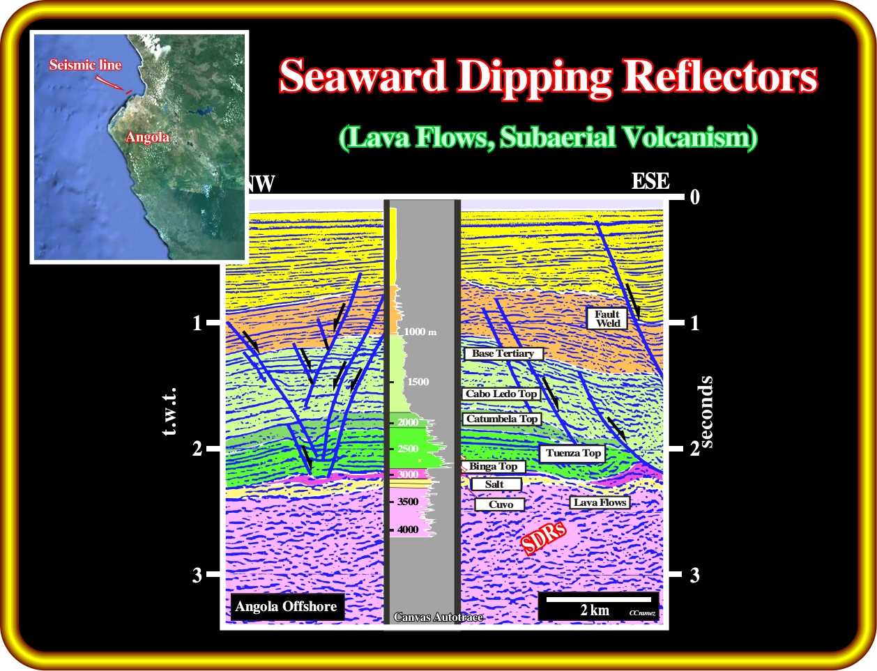
The Flamingo well, located in the Angola conventional offshore, not far from Luanda city, drilled more the 500 meters of lava flows,. The seaward dipping reflectors are well visible on this seismic line, as well as in the HDT (dipmeter electric log). In other words, the results of Flamingo well do not refute the hypothesis that, in Kwanza basin, the salt brines were enriched by a hydrothermal water - subaerial volcanic crust interaction. In Kwanza onshore several wells, as Puaça≠1, recognized lava flows which, locally, may be considered as reservoirs-rocks (producing gas in Puaça).
Clearly, the Aptian potash evaporites record hydrothermal interaction with a host rock that is probably basaltic. Such basalts could be the voluminous, rapidly emplaced SDRs, but these are not the only source. Spilitized basalts also form steadily at mid-ocean ridges. Alternation of KCl and MgSO4 types of potash evaporites has been linked to secular variation in seawater because of variations in sea-floor spreading rates (Hardie, 1996).
The Aptian had twice the modern spreading rate. Times of rapid spreading are marked by rise of sea level and sea-water temperature, changes in marine carbonate chemistry, and other greenhouse effects. Brines generated at mid-ocean ridges dominate those derived from river water, which ensures that hydrothermally derived KCl evaporites dominate. Thus, we cannot distinguish the setting (SDRs or mid-oceanic ridges) of the spilitized basalts that gave rise to KCl evaporites. However, the geochemistry is certainly compatible with Aptian evaporites accumulating over newly submerged flood basalts.
As the subaerial basalts subside, restricted circulation of inundating seawater can lead to the formation of evaporites directly on proto-oceanic basalts.
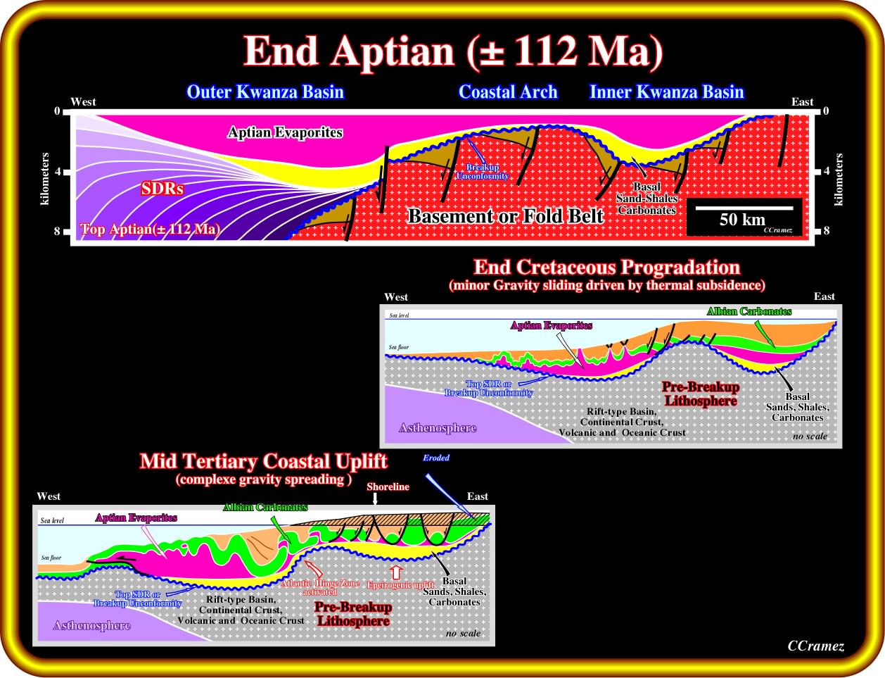
As illustrated in the upper geological cross-section (end Aptian), the Outer and Inner Kwanza basins, separated by the Coastal Arch, represent two salt depocenters with respective basal sand shale intervals (locally, i.e., in the high points, limestones (reefs) are possible). The depocenters (salt and basal sediments) were deposits immediately above of the breakup unconformity (in blue), which marks the end of the lengthening of the lithosphere (formation of the rift-type basins) and the beginning of the volcanic subaerial expansion with emplacement of the lava flows. As the subaerial basalts subside, restricted circulation of inundating seawater can lead to the deposition of the infra-salt basal sediments and the rich potash evaporites. In fact, the brines seem to be enriched by hydrothermal water - volcanic material interaction. At end Cretaceous (middle geological cross-section), seaward of the Atlantic Hinge Zone (western limit of the Coastal Arch) gravity sliding driven by thermal subsidence created extension structures, in the upper part, and compressional salt structures in western part. The lower geological cross section (Mid Tertiary time), illustrates the reactivation of the Atlantic hinge zone and the coastal uplift, as well as, the seaward advance (± 7 kilometres) of the Angola Salt Nappe with formation of the Angola escarpment.
It is important to notice that the COB, i.e., the Continental-Oceanic Boundary (the term oceanic should be replaced by volcanic, which includes the subaerial crust (SDRs) and t oceanic crust (sheeted dykes), is strongly affected by the fractures zones (see next plate), which partially control the oceanic expansion. In other words, the spatial distribution of the SDRs is much more complicated than that depicted in previous plate (End Aptian ± 112 Ma).
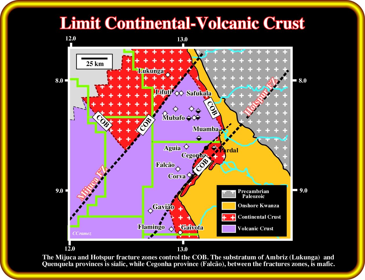
This plate depicts a tentative mapping of the limit between the continental and the volcanic crust (here, the subaerial lava flow, SDRs) in the Angola conventional offshore westward of Luanda city (exploration blocks 6,5,19, etc). This map strongly suggest that the old Precambrian fracture zones (here the Mijuca and Hotspur) control the subaerial (SDRs) and oceanic expansion (sheeted dykes and pillow-lavas), which started immediately after the breakup of the Gondwana supercontinent. On the other hand, it is quite obvious that the spatial distribution of the SDRs is affect by the movement of the fracture zones (similar to the movement of piano keys). Northward of the Hotspur fracture zone, the COB shows an apparent eastward displacement of more or less 50 km. Consequently, a seismic line crossing fracture zone can show an abnormal and abrupt change from continental to volcanic crust. Just the dip seismic lines shot within the same geological province (area bounded by two consecutive fracture zones) show the really characteristics of the SDRs.
Perhaps the most vivid modern example of this is the Afar region of Djibouti in the Horn of Africa. Here, where the Ethiopian plume, the Red Sea rift, and the Aden spreading ridge all meet subaerially, evaporites are accumulating directly on proto-oceanic basalt crust. A prime example is the evaporites around Lake Assal, in the Afar region of Djibouti in the Horn of Africa (Manighetti et al., 1997). With these kinds of topographic dams, seawater periodically spills in and evaporates subaerially to form salt below sea level. These evaporites are coeval with proto-oceanic spreading. They form part of the post-rift package, whose accommodation space is provided by crustal thinning, cooling, magma withdrawal, and SDR wedges loading continental margins (Benson, 1999).
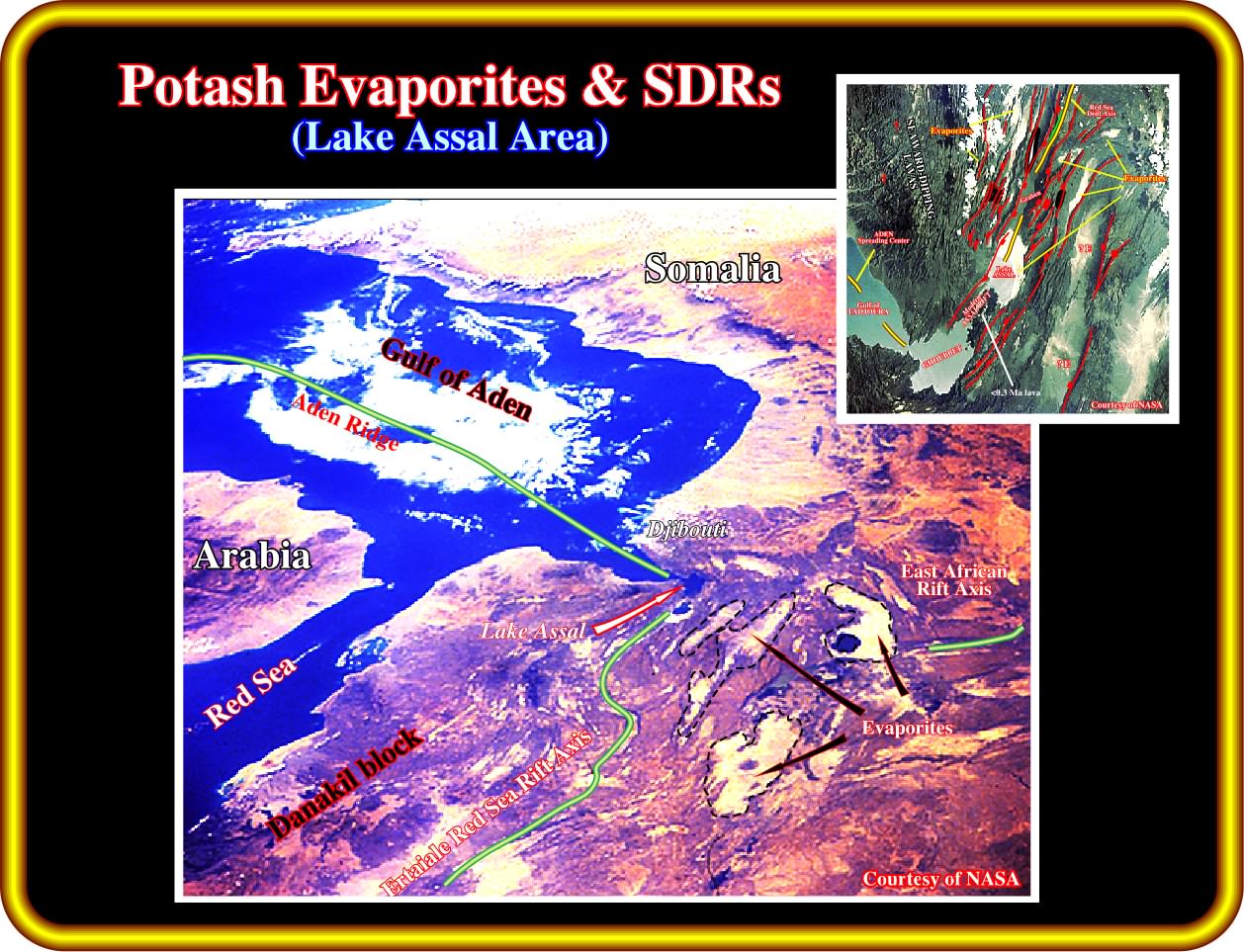
On of the best example of potash evaporite deposited from enriched brines, due to an hydrothermal water-volcanique material interaction, is the Afar region of Djibouti in the Horn of Africa. As said previously, due to the volcanic (SDRs) topographic dams, seawater periodically spills in. The brines are enriched in potash by hydrothermal seawater-SDRs interaction and then evaporated subaerially to form salt below sea level. These evaporites are coeval with proto-oceanic spreading.
Are there modern analogues for subaerial mid-oceanic ridges ? Almost all present-day mid-oceanic ridges are submerged, but this is a feature of old, wide oceans. A fitter analogy would be the subaerial parts of mid-oceanic ridges currently thermally elevated by an underlying mantle plume, such as the Djibouti Afar on the Aden Ridge or Iceland on the Reykjanes Ridge. The Afar hot spot bulge allowed synrift Messinian evaporites to form throughout the Red Sea while open-marine conditions existed farther south in the Gulf of Aden (Crossley et al., 1992).
As in Afar, the Aptian salt basins were confined to the south by the subaerial swell of the proto Walvis Ridge and Rio Grande Rise. These ridges separated open-marine conditions in the south from restricted marine conditions in the north. In the northern parts of both the Walvis Basin and the conjugate Pelotas Basin, where volcanism was most abundant, the initial oceanic crust kept close to sea level or at a shallow depth until almost the Turonian (91 Ma, some 20 my after breakup ; Abreu, 1998 ; Dingle, 1999). So it is likely that the mostly subaerial volcanic ridges acted as a dam. Gaps in the ridges would have allowed restricted access of seawater to the northern proto South Atlantic (Henry and Abreu, 1998). That would favour evaporitic conditions even after the oceanic crust had thermally subsided below sea level, as in the Messinian Mediterranean.
However, simple evaporative drawdown would not suffice : assuming an average salt concentration of 3.5%, complete evaporation of the world’s oceans would yield a salt layer only 60 m thick (Borchert and Muir, 1964). The equivalent salt thickness for a single evaporative drawdown in the proto South Atlantic would probably be less than 20 m, given the average water depth of the present South Atlantic (± 4500 m) compared with the youthful depth typified by the modern Red Sea (± 1000 m). Because the Aptian salt thickness averages at least 1000 m, at least 50 cycles of complete filling and evaporation would be required in the 10 My available. Open-marine conditions were only established in the middle-upper Albian (Dingle, 1999).
Exercise 1 :
Suppose that in a particular Atlantic offshore an exploratory well found two salt autochthonous layers, that is to say, two salt layers resting in the original strata or surface on which it accumulated by evaporation. The upper salt layer clearly postdate the breakup unconformity (breakup of the Gondwana lithosphere). Concerning the lower salt layers, there is a schism. For certain geoscientists, the lower salt layer postdates the breakup unconformity, that is to say, it was deposited at the bottom of the margin, but for other it predates the unconformity, that is to say, they place it within a rift-type basin. What is for you the best way to test both conjectures ? Justify you answer.
to continue press
next
![]()
Send E-mail to carloscramez@gmail.com or to carlos.cramez@bluewin.ch with questions or comments about this workshop (Salt Tectonics Workshop for Kwanza and South Congo basin).
Copyright © 2013 CCramez
Last modification: June-July, 2013