
4- Is the Bottom of the Salt a Major Stratigraphic Horizon?
The real major stratigraphic subdivision is :
(a) Basement, which can be granite-gneiss or a Paleozoic fold belt (Karoo included), that is to say the Gondwana lithosphere ;
(b) Rift-type basins sediments and
(c) Atlantic type Divergent Margin sediments, as illustrated below.
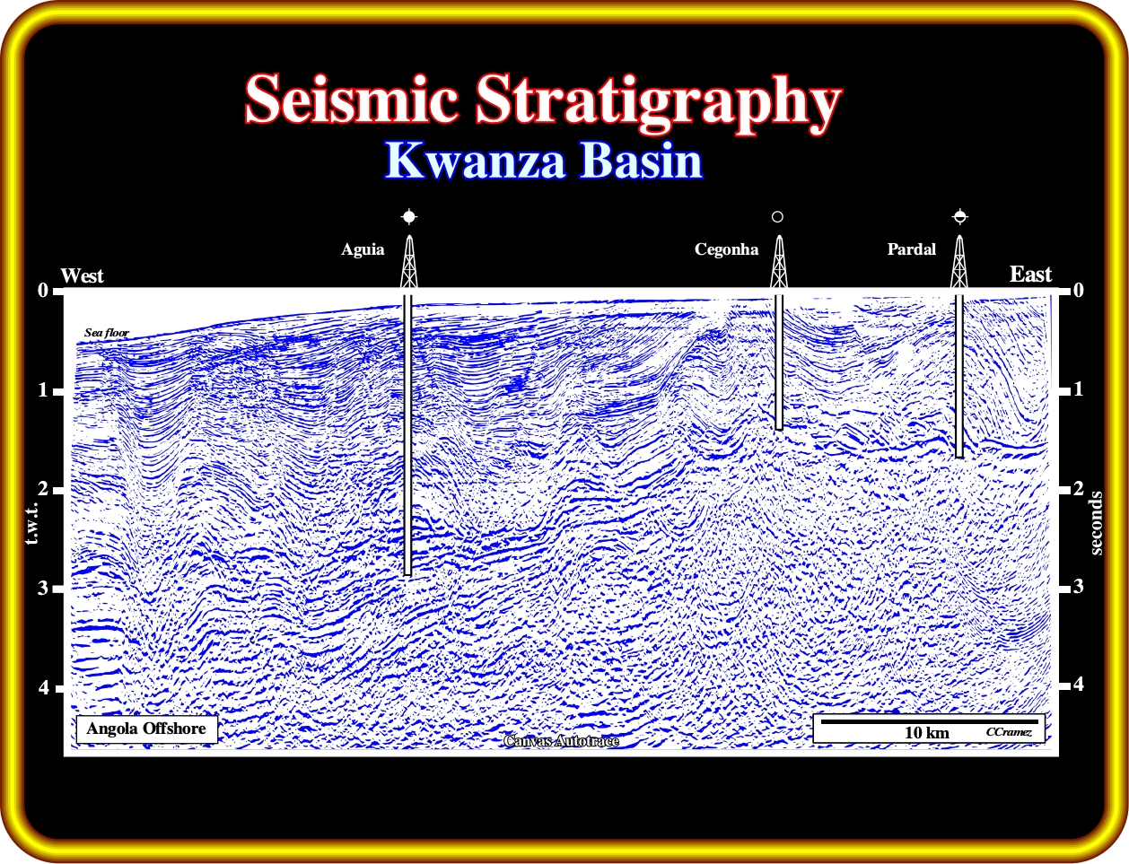
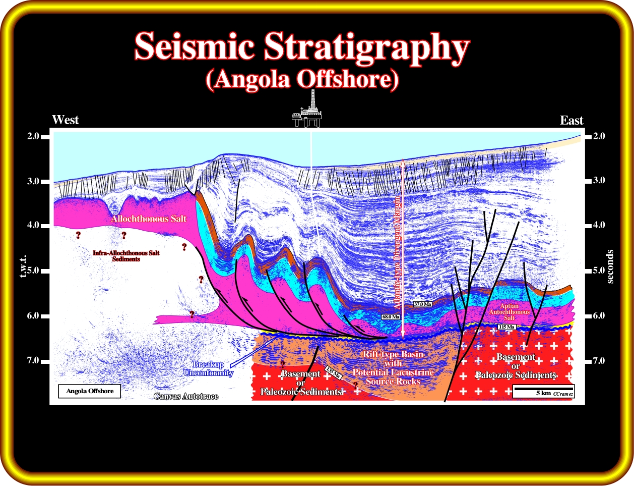
On this seismic line from the Kwanza basin, it is relatively easy to differentiate the major seismic packages, which represent the principal geological events of the evolution of this offshore. Admittedly, there is an obvious seismic surface all along of this line, which underlies a tectonic disharmony (if you take into account the seismic artefacts induced by lateral velocity variations, the overlying sediments are deformed, generally, lengthened, while the underlying sediments are undeformed) that interpreters recognize immediately. Such a seismic surface corresponds to the bottom of the salt layer or associated salt welds. The more significant seismic surfaces are those underlying (i) the beginning of the lengthening of the Gondwana lithosphere (pre-rifting unconformity), (ii) the breakup of the Gondwana lithosphere, which ends the lengthening of the lithosphere (formation of rift-type basins) and (iii) the beginning of volcanic (subaerial and oceanic) expansion, which marks the continental drift. All these seismic surfaces are depicted in next plate.
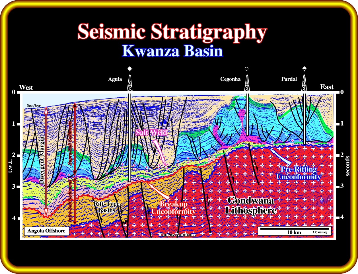
As you can recognize on this geological tentative interpretation of the previous seismic line, the bottom of the salt layer (or associated salt welds) corresponds just to a tectonic disharmony induced, mainly by halokinesis, i.e., it does not correspond to a significant geological event. In this tentative, from bottom to top you recognize : (i) The Gondwana lithosphere (basement or Paleozoic fold belt) ; (ii) The rift-type basins, which are developed during the lengthening of the Gondwana lithosphere and before its breakup ; and (iii) The divergent Atlantic-type continental margin, which was deposited after the breakup of the lithosphere and the deposition of the subaerial lava flows (not visible on this seismic line), and in which an Aptian salt layer was deposited, mainly, in two depocenters (Inner and Outer Kwanza Basins). When a geoscientist speaks in infra-salt sediments he must knows that he is speaking in two completely different kind of sediments : (a) Rift-type basin sediments, deposited in association with a differential subsidence, before the breakup of the lithosphere, which is the mainly geological event of the area, and which, generally, are non-marine and (b) Post breakup sediments, deposited in association with a thermal subsidence, which are mainly marine sediments.
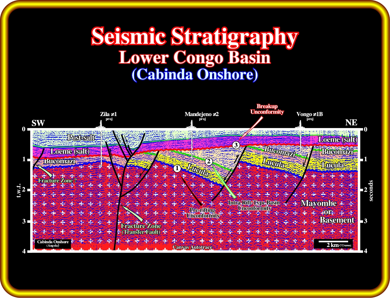
In Cabinda onshore, as illustrated in this geological tentative interpretation, the pre-rifting unconformity (1) is quite easy to recognize by the toplap geometrical relationships (below) and a more or less concordance with the overlying sediments. The breakup unconformity (3), which corresponds, more or less, to the bottom of the salt layer, since the thickness of the margin infra-salt sediments is under seismic resolution. Within the rift-type basins, below the breakup unconformity, two major sedimentary intervals can be individualized by an angular (tectonically enhanced) unconformity (2). As we will see later, the bottom of the salt corresponds to an unconformity within the divergent Atlantic-type margin, which, locally, it is easy to recognize. In other words, in Cabinda onshore the major stratigraphic intervals are (i) Pre-rifting ; (ii) Rift -type Basins and (iii) Atlantic-type divergent margin, characterized respectively, by the Gondwana lithosphere, the lengthening of the Gondwana lithosphere (differential subsidence) and the breakup of the Gondwana lithosphere with deposition of the margin sediments (thermal subsidence).

Exercise 1 :
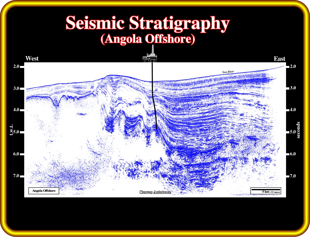
Using this seismic line of the Angola deep offshore, we must propose a geological tentative interpretation, trying to pick the unconformities underlying :
(1) The beginning of the lengthening of the Gondwana lithosphere, that is to say, the pre-rifting unconformity.
(2) The breakup of the Gondwana lithosphere.
(3) The more likely limits of the salt layer.
(4) The different fault systems.
(5) The infra-salt margin sediments, i.e., the clastic interval between the breakup unconformity and the bottom of the salt.
Exercise 2 :
Criticize the proposed tentative geological interpretation. Explain the different fault systems and the potential petroleum traps.
to continue press
next
![]()