III- Opening Hypothesis with SDRs
In Atlantic-type Divergent Margins (Bally and Snelson, 1980), Total's geologists, after stopping several exploration wells in subaerial volcanism, tried to understand what such a thick subaerial volcanic bodies were doing in what as considered as non-volcanic divergent margin. Indeed, since the French geologists (Montadert et al., 1974) published the seismic lines from west Iberia margin, the majority of the academic geologists took this quite particular margin (Newfoundland / Iberia) as the typical model for North and South Atlantic margins and considered them as non-volcanic margins. The results of Total's researches, as described next, completely change such an erroneously approach. The Total's model (Fonck et al., 1998) can be depicted by the geological cross-section of the northern offshore Angola (Cramez, 2000) illustrated below .
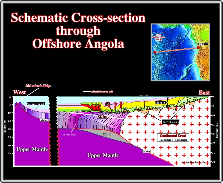
This depth interpretation of a long composite regional seismic line from the Northern Offshore Angola depicts how the majority Total's geologists see the opening of Atlantic Ocean. In this interpretation one can recognized: (i) the continental crust with their rift-type basins, (ii) the breakup unconformity (BUU), (iii) the lava flows (SDRs), with the associated sheeted dikes and the oceanic crust are, overlying the breakup (BUU) and SDRs (SU) unconformities and (iv) the margin sediments, affected by a strong salt tectonics, in which the transgressive and regressive phases of the post-Pangea continental encroachment cycle are easily distinguished. Thoroughly, the Total's model can be described as follows:
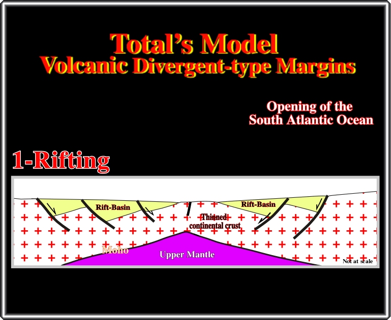
Rifting: the continental crust of a supercontinent, the Rodhinia or Proto-Pangea (Dalziel, I.W.D., 1995), for instance, was lengthened by normal faults, generally with an opposite vergence, and so, the lithosphere became relatively thin. The lengthening created rift-type basins, which were filled mainly by non-marine sediments. Three main sedimentary intervals are often recognized within rift-type basins. From bottom to top, on the ground or on seismic lines, one can see : (i) alluvial fans, (ii) lacustrine shales (often rich in organic matter, i.e., potential source rocks) and (iii) fluvial or deltaic sediments. As the continental crust lengthened, it thinned and was strongly injected by metallic basaltic material. On this subject (lengthening) is difficult to know what is the cause and the effect: Is the lengthening the cause of the thinning, or the thinning the cause of the extension?
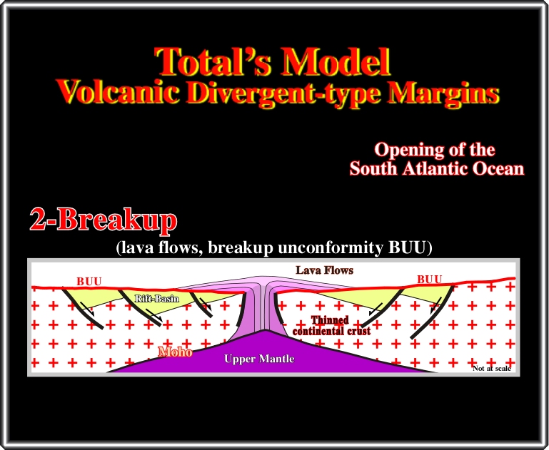
Breakup of the lithosphere: When the lengthening of the continental crust reached a factor ß near 3.5-4.5, its thickness was around 10-15 km and became highly intruded by mantle material (Dewey, J. F., 1982). Therefore, mechanically speaking, it could not anymore be lengthened by normal faults and so it split into two lithospheric plates (it was the breakup of the lithosphere). The emplacement of sheeted dikes and associated basaltic lava flows (subaerial environment) fossilized the rift-type basins, and the break-up unconformity BUU, creating structural raised volcanic areas, as illustrated above, or filling low or fractured areas. Symmetrically, the lava flows thin away of the linked sheeted dikes (sub-aerial spreading centres), that is to say, toward the continent. At this stage, it is quite important to differentiate the lava-flows from the rift-type basin sediments. However, one should not forget that, in a subaerial environment, few and thin terrigeneous sedimentary layers, can be found between the lava flows (SDRs).
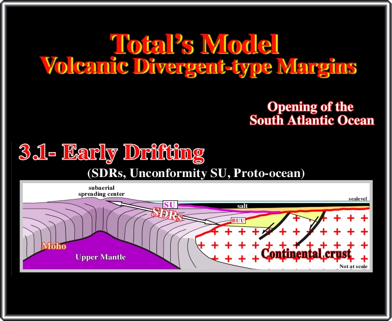
Early Drifting: The stacking of successive lava-flows obliged the older to tilt seaward creating, gradually, seaward dipping time lines. Two twin symmetric shallow basins were formed, between the subaerial spreading centres and the continents (Jackson, P. A. et al., 2000). Progressively, the sea invaded the new lithospheric plates and fluvial shallow marine sandstones and evaporite were deposited in the twined shallow water salt basins. These evaporites, particularly in the South Atlantic margins, are quite particular. They are rich in potash and poor in MgSO4 (carnalite, tachyhydrite, bischofite, sylvite). Their brines were enriched by spilitisation. The basalt of the lava was hydrothermally altered to spilite greenstones. At this stage (early subaerial drifting), the lava-flows, and the rift-type sediments, dip in opposite directions and two distinct major unconformities are recognized: (i) the breakup unconformity (BUU) and (ii) that associated with the top of the SDRs (SU).
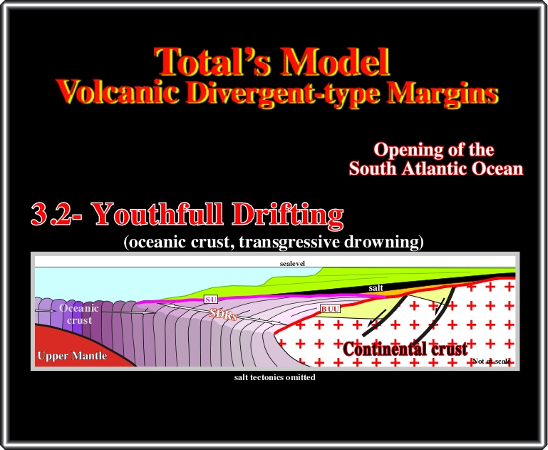
Youthfull Drifting: when the weight of the lava-flows, in conjunction with the eustatic rise, submerged the spreading centres, the mantle material, arriving at sea floor, was frozen into pillow lava It was the beginning of oceanic crust (volcanic material cannot flow under water) and a unique oceanic basin was born. The seaward subsidence of the margin enhanced the eustatic rise and a transgressive sedimentary interval was deposited in the margins of the basin above the evaporites. The sediments were strongly deformed by salt tectonics (Duval, B. et al., 1992), but the backstepping geometry of the transgressive sediments is easily recognized (Duval, B. et al., 1998). This transgressive episode prevails till the Cenomanian-Turonian eustatic high when the encroachment of transgressive sediments was maximal (maximum flooding surface 91.5 Ma).
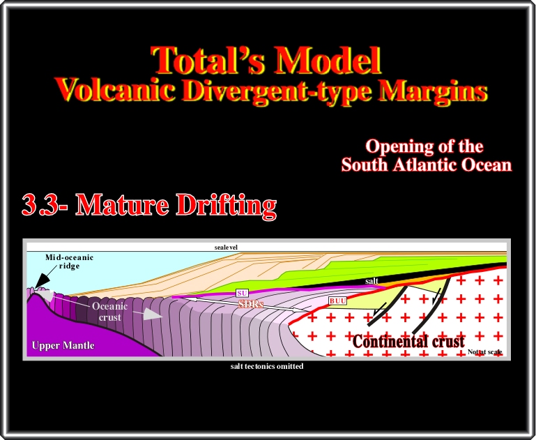
Mature Drifting: At the maximum flooding surface (MFS 91.5 Ma), that is to say, at the limit between the green (backstepping) and brown interval (forestepping), the shoreline was far away up-dip of the shelf break (basin with platform). Then, the eustatic fall initiated a regression characterized by progradational internal geometry. Progressively, the maximum flooding surface was fossilized, by forestepping, creating a major downlap surface. As the depositional coastal breaks (roughly the shorelines) moved seaward, the size of the platform decreased. Subsequently, after a given time, the basin had no more platform (depositional coastal break and shelf break become coincident) and so, the toe of the continental slope started to cover the pillow lava, and seamounts of the oceanic crust. At this stage, it is quite important to say: SDRs dip toward the sea, while rift-type basin sediments dip, generally, toward the continent.
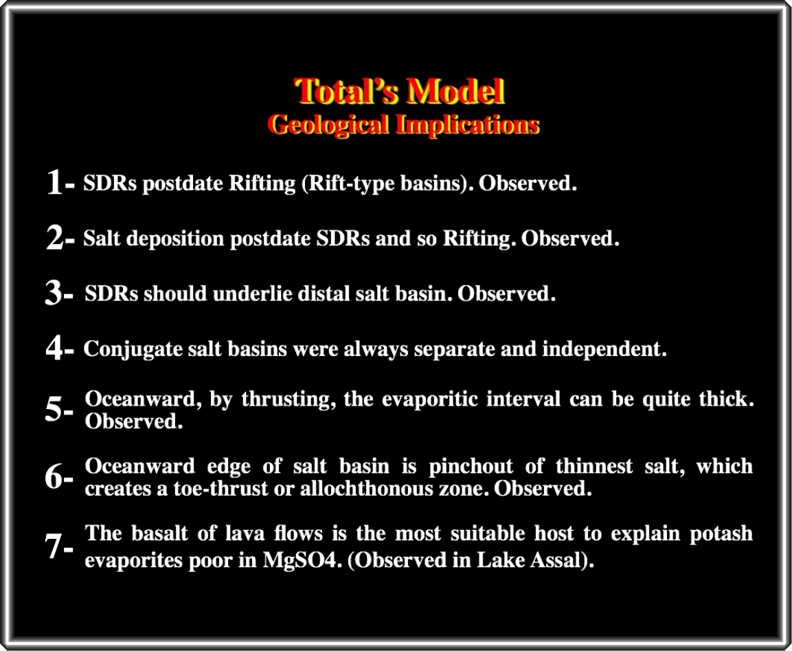
From the geological implications of the Total's hypothesis, summarized in the plate below, at the petroleum exploration standpoint is quite important to underline that SDRs, postdating the rift-type sediments, are posterior to one of the major generating petroleum subsystem, explicitly, the lacustrine potential source rocks. On the other hand, a misleading between the breakup unconformity (below the SDRs) and the unconformity at the top of the lava flows can have heavy consequences in the calculation of the maturation of the organic matter of the potential source rock intervals.
From the above geological implications, the chemical and mineralogical compositions of the evaporites in the South Atlantic Margins (and probably those in Gulf of Mexico and North Atlantic) are quite interesting since they are akin to those located in the Afar triple junction.
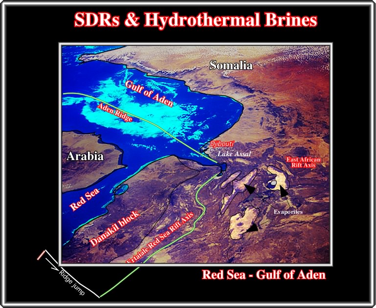
Indeed, in Dibouti, Horn of Africa, at the convergence of the East African-Rift axis, the Aden Ridge and the Ertaiale Red Sea Rift axis, there are particular evaporitic deposits, as indicated above. In addition, they are the best present examples where MgSO4 poor potash evaporites are formed by spilitisation of the basalt of the lava-flows deposited around the Lake Assal. These lava-flows are quite well recognized on space shuttle photograph STS 41G-35-104 (see below) shot in 1984 (courtesy of NASA).
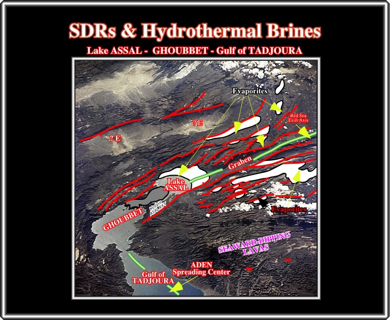
The evaporites, appearing in the photograph as white patches, were deposited subaerially below sea level (roughly 250 meters below present sea level) in association with half grabens. Their composition and mineralogy is similar to those evaporites of the South Atlantic margins and probably also to the evaporites of North Atlantic margins and Gulf of Mexico (Lohan salt). Admittedly, their brines have been hydrothermally enriched.
to continue press
next
![]()
Send E-mail to carloscramez@gmail.com or to carlos.cramez@bluewin.ch with questions or comments about this conference.
Copyright © 2006 CCramez
Last modification: August,2014