
IV- Refutation of Total's Hypothesis
As any other geological hypothesis, sooner or later the Total's hypothesis will be partially or completely falsify. However, so far, and particularly for the Atlantic-type divergent margins (Bally, A. and Snelson, S., 1980), as we will see below, it has resisted to the majority of the tests. Actually, scientifically speaking, hypotheses cannot be verified but just refuted (Popper, K., 1981 and 1984). On this subject, it is important to point out that, in English, "verification", "validation" and "corroboration" are not synonyms (Naomi, O., 1994).
Regional seismic lines and well results from different areas of the South Atlantic Margins (Namibia, Argentina, Brazil, Guyana and Angola) strongly corroborate, i.e., do not falsify the hypothesis advanced by Total’s geologists to explained the creation and evolution of the Atlantic-type divergent margins of South Atlantic.
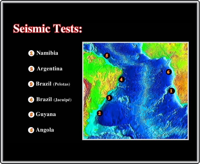
We will start from the seismic lines from the offshore Namibia, where the SDRs are quite evident. Then, we will show the lines from western margin, before returning to Angola offshore where the SDRs are more subtle.
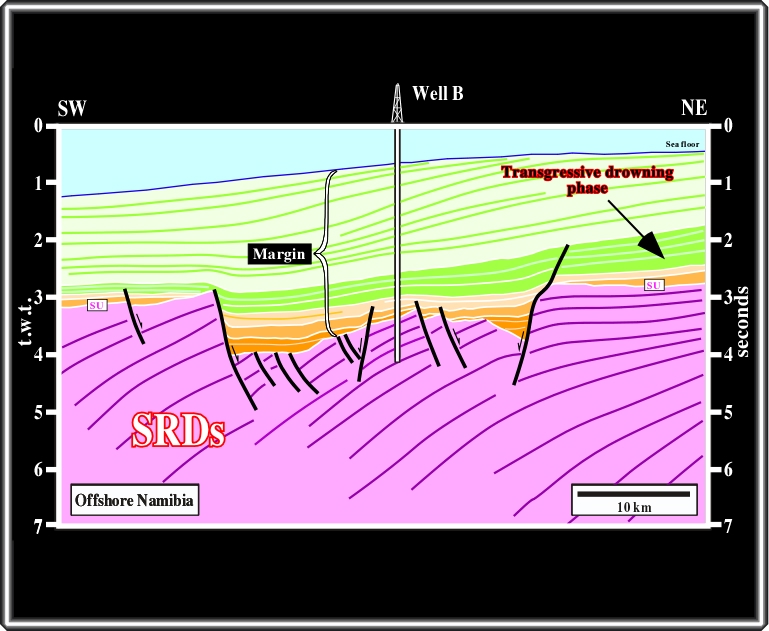
In the 90’s, in this area, several major oil companies drilled wildcats looking for hydrocarbons generated by potential lacustrine source rocks deposited in rift-type basins developed in the continental crust. In other others, the reflectors in the lower part of the line, which are tilted and looking seaward, were interpreted as induced by sedimentary interfaces within Lower Cretaceous rift-type basins. However, all wells were ascertain subaerial lava flows and not the so desired lacustrine shales equivalent of the Bucomazi shales of Cabinda offshore (Angola).
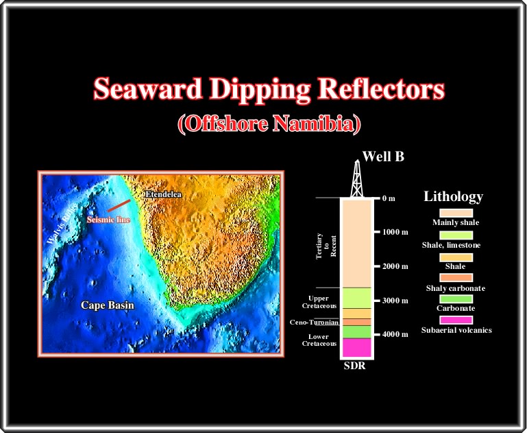
The well’s results, as illustrated in this sketch, strongly emphasized the lack of knowledge of oil companies in relation to academia, at least on this subject. The seismic reflectors interpreted as potential hydrocarbon source rocks were just post breakup lava-flows with any generating hydrocarbon potential, i.e. SDRs. Astonishingly, even after the results of the first well, several oil companies continue drilling expecting to find, in Namibia, the Cabinda Eldorado, i.e. the Bucomazi formation of the rift-type basins of the northern offshore Angola. Hitherto, they just found lava-flows.
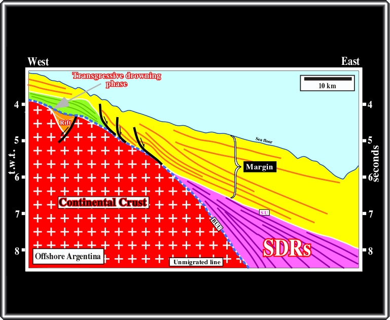
This seismic line from the offshore Argentina, clearly illustrates the difference between rift-type basins (pre-dating the breakup) and SDRs (post-dating the breakup). Cleverly, in terms of hydrocarbon potential Argentine's explorationists, following K. Hinz’s works, considered this offshore as very poor. Indeed, as recognized on this line, the thickness of the margin sediments is to small to develop a generating petroleum sub-system.
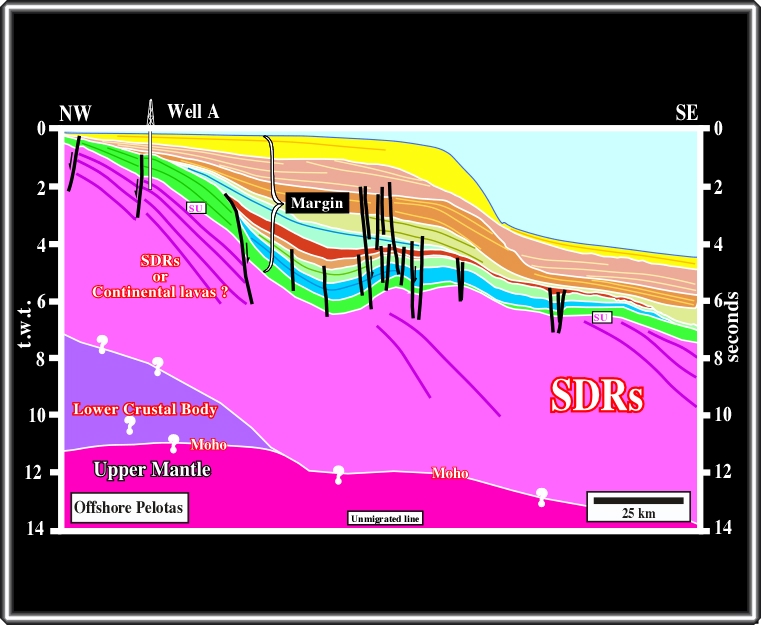
This seismic line from the offshore Brazil (data from Fontana, 1996 and Caineli and Mohriak, 1998), undoubtedly illustrated Petrobras's explorationists drilled a lot of wildcat assuming that rift-type basins with potential source rocks were always present in this offshore. Unfortunately, the results of the wells drilled southward Santos basin, and particularly in Pelotas basins, seem to be noteworthy: absence of source rocks.
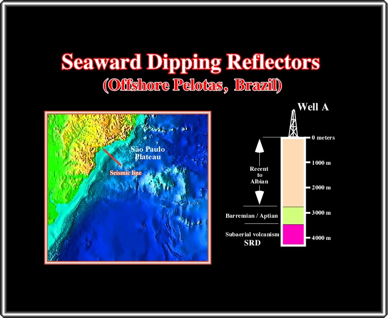
As said previously, the well’s results of Pelotas basin, indicated that the substratum of the basin was composed by volcanic material, which seismically speaking can be interpreted as build-up by SDRs, i.e. lava flows. In terms of petroleum exploration, these wells strongly suggest the absence of a rift-type basin generating petroleum subsystem.
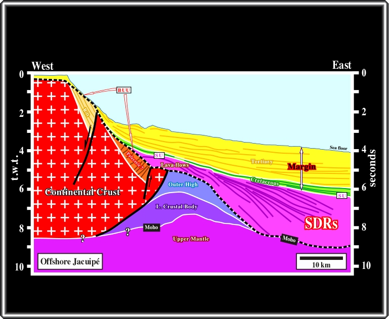
In Brazil, the turnover took place in 1997. Indeed, during the São Paulo convention, a Brazilian geologist (W. Mohriak) showing the regional line of Jacuipé basin (roughly interpreted as illustrated above) said: “Before J.C., the light pink interval was interpreted as a rift-type basin with huge hydrocarbon potential. After, J.C. (may be himself), this same interval, was interpreted as lava-flows post-dating the breakup (BUU), that is to say, an interval with a nil hydrocarbon potential”. See this line in Mohriak (1998).
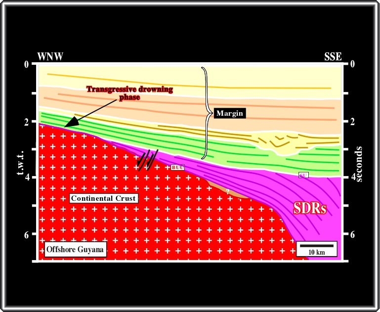
Going northward, to Guyana, a major oil company, after understanding the poor hydrocarbon potential of certain of their exploration blocks (taken to look for hydrocarbons generated by rift-type basin source rocks) try to farmout them. This line illustrates a typical example. Indeed, several years ago, several geologists came to my office to sell me the best, and thicker, potential source of the area (the pink interval). Unfortunately, they forgot two thinks. Firstly, I was closely tie with the academia. Secondly, I knew the results of a nearby wildcat that stopped in lava-flows.
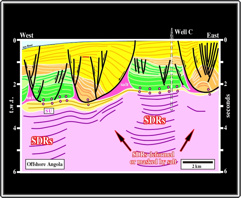
Returning to the eastern Atlantic margin, I remembered that in the 80’s, in offshore Angola, Total stopped a well in subaerial volcanics, after drilled almost 1000 meters of lava flows and nobody understood what the lava-flows were doing there. Today, even knowing the meaning and importance of the SDRs in the opening of South Atlantic, they are difficult to recognize, particularly on dip lines, due to the lateral changes in velocity induced by the salt layers, as illustrated above. However, as depicted below, the volcanic interval was cored, and the core as well the longitudinal seismic line, show a ± 15 º seaward (westward) dip.
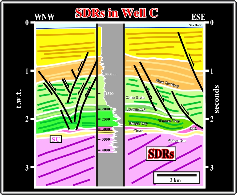
The well was located on this line. It is perpendicular to the previous one. The studies of core indicated a volcanic facies (lithology) for lower light pink interval. The ±15º seaward dip recognized on the core is corroborated by dip of the linked seismic reflectors on WNW-ESE seismic lines. At present, for the majority of explorationists working in the area, it is evident that such infra-salt volcanic interval correspond to post breakup lava flows. However, such a stratigraphic position was not evident at the drilling time.
to continue press
next
![]()
Send E-mail to carloscramez@gmail.com or to carlos.cramez@bluewin.ch with questions or comments about this conference.
Copyright © 2006 CCramez
Last modification: August, 2014