for
Kwanza and South Congo Basins
Caveat:
This workshop and particularly these notes should not be taken as an attempt to write a textbook on Salt Tectonics, but just an eclectic assemblage of geological models, cross-sections and tentative interpretation of seismic lines illustrating the main geological principles and hydrocarbon problems discussed during meetings on hydrocarbon potential of the onshore and offshore Angola (Total SA, Sonangol, Marathon Oil Company, Petrobrás and Pluspetrol), in which I participated. The text is reduced to a minimum. On the figures, as well as, on the tentative geological interpretations of the seismic lines, for confidential reasons, very often, the locations and orientations are not indicated. The large majority of plates and tentative interpretations are personal, but the original data belongs mainly to Sonangol and Total. So, none of them can be used or reproduced, publicly, in any manner whatsoever without written permission (carloscramez@gmail.com ; shengyu_wu@ccreservoirs.com) ; severino.cardoso@sonangol.co.ao).
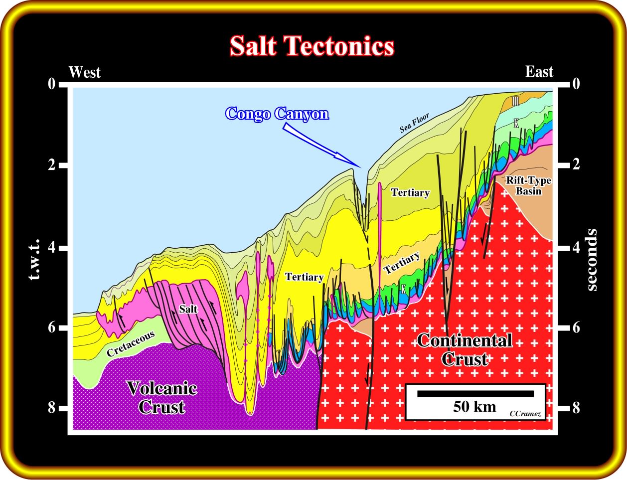
This geological tentative interpretation of composite seismic line of the Northern Angola Offshore (South Congo Basin) illustrates what we intend to convey by salt tectonics. The Rift-type basins and the Atlantic-type margin sediments, in which an evaporitic layer (Loeme Salt) was deposited, undergone different tectonic regimes. The regional tectonic regime was extensional and characterized by a maximum effective stress (σ1) vertical, a medium effective stress (σ2) horizontal, striking roughly NNE-SSW, and a minimum effective stress (σ3) horizontal (orthogonal to σ2 ). In other words, the sediments were mainly lengthened, in spite of the fact that, locally, they were shortened (salt layer included), particularly, in deep water offshore. Some of local compressional tectonic regimes were induced by reactivation of fracture zones, other associated with ridge pushing forces, or by readjustment of the lithospheric plate,. and others related with halokinesis (particular salt tectonics when the tectonic stress is null and σ2 and σ3 are equal and horizontal). It is easy to recognize that the sediments overlying the salt layer (in purple on this tentative interpretations) were much more deformed than the infra-salt sediments due mainly to halokinesis (form of salt tectonics in which salt flow is powered by buoyancy, that is to say, by release of gravity potential energy alone, in absence of significant lateral tectonic stress (σt = 0), as we will see later.
Workshop Overview:
This salt tectonics workshop was prepared for Sonangol petroleum geologists working in Kwanza and South Congo basins (onshore and offshore). Its purpose is to acquaint the participants not only with the basic concepts of salt tectonics, but with the main questions than geoscientists must solve during the petroleum exploration of these basins as well. Consequently, this workshop is presented on the form of questions, the more likely answers and exercises. Example, "Is the bottom of the salt layer an unconformity ?"
Contents:
1 - What is Salt Tectonics and Halokinesis ?
2 - Which are the Salt Characteristics ?
3 - What is the Origin of the Salt ?
4 - Is the Bottom of the Salt a Major Stratigraphic Horizon ?
5 - Is there an Unconformity of the Bottom of the Salt ?
6 - Is the Bottom of the Salt affected by a Basement Tectonics ?
7 - How many Salt Layers there are in Kwanza Basin ?
9 - How to Distinguish Extension from Welding ?
12 - How Petroleum Systems work in Raft Tectonics ?
14 - What are the stages of Diapirism ?
15 - What are the Interdomal Structures ?
16 - What means Rising and Reduction of a Diapir ?
18 - Which are Translation Onlap Surfaces ?
to continue press
next